18th Century and Earlier Prints
148
5,079
to
1,235
4,768
298
5,079
5,079
5,079
64
48
42
20
15
8
2
1
1
1
1
5,079
8,082
5,336
888
1,132
1,588
1,690
152
75
159
203
187
235
437
697
341
223
Height
to
Width
to
5,034
87
40
19
19
678
202
165
110
89
95
49
46
43
43
Period: 18th Century and Earlier
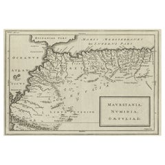
Rare Map of North Africa Depicting Numidia, Libia and Morocco, Published C.1740
Located in Langweer, NL
Antique map Africa titled 'Mauretania, Numidia, Gaetulia & c.'.
Rare map of North Africa depicting Numidia, Libia and Morocco.
Artists and E...
Category
Antique 18th Century and Earlier Prints
Materials
Paper
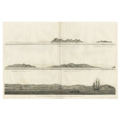
Antique Print of the City of Ten-Tchoo-Foo, China, 1796
Located in Langweer, NL
Antique print titled 'View of the City of Ten-Tchoo-Foo from the Anchorage of the Hindostan in the Strait of Mi-a-Tau Bearing South-West'. Together on a sheet with 'Cape Maccartney and Cape Gower'.
The top two views depict coastal profile views of local islands named after important people in the Embassy, including Macartney, Staunton, and Gower. Below, a view of the city of Ten-Tchoo-Foo taken from aboard the Hindostan, one of the ships on the mission. These land approach views appeared in the account of George Macartney's travels to China, published by George Nicol. Macartney was Britain's first envoy to China, and was tasked with convincing Emperor Qianlong to ease restrictions on trade between Great Britain and China by allowing the British to have a permanent embassy in the country. Sir George Staunton prepared the official report, 'An Authentic Account of an Embassy from the King of Great Britain to the Emperor of China', which included charts and views based on manuscript sketches and drawings by Sir John Barrow...
Category
Antique 18th Century and Earlier Prints
Materials
Paper
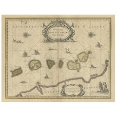
Old Map of the Moluccas, Known as the Famous Spice Islands, Indonesia, ca.1730
Located in Langweer, NL
Antique map titled 'Insularum Moluccarum Nova Descriptio.'
Old map of the Moluccas. The famous Spice Islands, the cornerstone of the Dutch trading empire in the East Indies throughout the 17th Century, is the focus of this exquisite map. Similar to Blaeu's map, except that it extends further south...
Category
Antique 18th Century and Earlier Prints
Materials
Paper
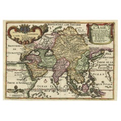
Rare Unusual Antique Map of Asia with a Landbridge from Korea to America, 1717
Located in Langweer, NL
Antique map titled 'L'Asie Suivant les Nouvelles Decouvertes (..).' Interesting and very unusual map of the Asian continent. The map is based primarily on Dutch sources, particularly the outlines of Siberia and the East Indies. However, the most striking feature, which is original to De Fer, is a continuous landbridge extending from northern Korea and eastern Siberia across to America. A note acknowledges Portuguese sources for this new portrayal of the region. Hokkaido (Ieso) appears as a small circular island north of Japan. The northern coastline of Asia is based on Witsen's explorations including Cap Tabin and Cap Glace. The interior is filled with details, including what appears to be a road from Moscow to Peking, and the Great Wall of China. The Caspian Sea is presented in an unusual shape. The coastline of a portion of New Guinea is incorrectly named as Nouvelle Zeelande. Graced with three beautifully designed cartouches.
This scarse map originates from: 'Introduction a la geographie - avec unde description historique sur toutes...
Category
Antique 18th Century and Earlier Prints
Materials
Paper
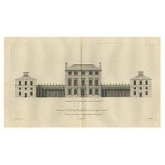
Old Engraving of Chesterfield House, Westminster in London, Uk, ca.1770
Located in Langweer, NL
Title: Antique print titled 'Elevation of the R. Hoble Earl of Chesterfields House (..)'.
Old engraving of Chesterfield House, Westminster. It was a ...
Category
Antique 18th Century and Earlier Prints
Materials
Paper
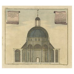
Old Antque Pirint of the New Dutch Church of Batavia 'Jakarta, Indonesia', 1744
Located in Langweer, NL
Antique print titled 'Ein Aufzug und Durchschnitt der Neuerbauten Holländischen Kirche in Batavia nach den Maastaab aufegzogen'.
Old print with a cross-section of the new Dutch church of Batavia (Jakarta). This print originates from from 'Allerneuester Geographische- und Topographischer Schau-platz, von Africa und Ost-Indien'.
Artists and engravers: Johann Wolfgang Heydt, a German artist who worked for the Dutch East India...
Category
Antique 18th Century and Earlier Prints
Materials
Paper
Old Antique Print of Fort Noordwijk, Batavia 'Jakarta, Indonesia', 1739
Located in Langweer, NL
Antique print titled 'Ein Prospect des Forts Nortweijck, wie sich dasselbe wan man von Jacatra komt, mit seiner Gegend präsentiret'.
Old print of Fort Noordwijk, Batavia (Jakarta)....
Category
Antique 18th Century and Earlier Prints
Materials
Paper
North & South America: A 17th Century Hand-colored Map by Jansson & Goos
Located in Alamo, CA
A 17th century hand-colored map of North & South America entitled "Americae Descriptio" by the cartographer Johannes Jansson, published in Jansson's Atlas Minor in Amsterdam in 1628....
Category
Dutch Antique 18th Century and Earlier Prints
Materials
Paper
Original Hand-Colored Antique Regional Map of Switzerland, 1753
Located in Langweer, NL
Antique map Switzerland titled 'Territorium Reipublicae liberae Helveticae Scaphusiensis (..)'. Regional map of Switzerland.
Artists and En...
Category
Antique 18th Century and Earlier Prints
Materials
Paper
Antique Map of Italy, Showing Corsica, Sardinia, Croatia, Malta and More, C.1740
Located in Langweer, NL
Antique map titled 'Nieuwe Kaart van Italie na de Nieuwste waarnemingen van de l'Isle en andere.'
Attractive detailed map showing Italy as well as Corsica, Sardinia, Minorca, Croat...
Category
Antique 18th Century and Earlier Prints
Materials
Paper
Detailed Regional Antique Map of Northwestern France and Catholic Belgium, 1648
Located in Langweer, NL
Antique map titled 'Picardie et les Pays Bas Catholiques (..)'.
Detailed regional map of Northwestern France and Catholic Belgium, from an early edition of Sanson's Atlas.
Art...
Category
Antique 18th Century and Earlier Prints
Materials
Paper
Old Handcolored Antique Map of Pays De Caux in Normandy, France, ca.1640
Located in Langweer, NL
Antique map titled 'Le Pais de Caux'.
Old map of Pays de Caux, France. Pays de Caux is an area in Normandy occupying the greater part of the French département of Seine Maritime ...
Category
Antique 18th Century and Earlier Prints
Materials
Paper
Interesting Old Map of the Nw Coast of America and the Ne Coast of Asia, ca.1772
Located in Langweer, NL
Antique map titled 'Carte Generale des Decouvertes de l'Amiral de Fonte (..)'.
Original antique map of the discoveries of Admiral de Fonte, showing the possibility of a north-west passage. Interesting map of the NW Coast...
Category
Antique 18th Century and Earlier Prints
Materials
Paper
Old Print of a Partridge in Front of The Walled City of Azemmour, Morocco, c1630
Located in Langweer, NL
Antique print, titled: 'Azaamurum.' - Caption in the top reads: 'Foenerari iniustum est'.
A partridge in the foreground, with the walled city (Azemmour...
Category
Antique 18th Century and Earlier Prints
Materials
Paper
Antique Map of Northern Europe and European Russia, ca.1780
Located in Langweer, NL
Antique map titled 'Le Nord de L'Europe, Contenant Le Danemark, La Norwege; La Suede et La Laponie avec la Majeure Partie de al Russie Europeenne.'
Map of Northern Europe and Eur...
Category
Antique 18th Century and Earlier Prints
Materials
Paper
Original Antique Miniature Map of Persia, Published, ca.1601
Located in Langweer, NL
Antique miniature map titled 'Persia'. Small map of Persia published in the Epitome, or pocket-edition of the "Theatrum Orbis Terrarum".
Artists and e...
Category
Antique 18th Century and Earlier Prints
Materials
Paper
Framed View of the Brouwersgracht in Amsterdam, the Netherlands, 1708
Located in Langweer, NL
Antique print titled 'Societatis Indiae Occident (..) - West Indisch Huys op Raapenburg (..)'.
Despite the title suggesting this print is a view of the West-Indisch House in Amst...
Category
Antique 18th Century and Earlier Prints
Materials
Paper
Antique Map of Japan with Scale and Compass Rose, c.1730
Located in Langweer, NL
Antique map titled 'Naauwkeurige Kaart van 'T Keizerryk Japan (..).'
Attractive detailed map of Japan. With scale and compass rose. This map originates from 'Hedendaegsche historie...
Category
Antique 18th Century and Earlier Prints
Materials
Paper
Print of the Fortress Julaof Tokay, Hungary, Surrounded by Turkish Troops, c1580
Located in Langweer, NL
Antique print Hungary titled 'Contrafehtung der Festung Tokay'.
Birds eye view of the fortress Julaof Tokay, Hungary, surrounded with Turkish troops. Originates from a German edi...
Category
Antique 18th Century and Earlier Prints
Materials
Paper
Dutch Antique Map of the West Coast of Africa, to the Cape of Good Hope, 1747
Located in Langweer, NL
Antique map of the Coast of Africa titled 'Kaart van de West Kust van Afrika (..)'.
Map of the west coast of Africa, from 11 degrees south latitude to the Cape of Good Hope. This...
Category
Antique 18th Century and Earlier Prints
Materials
Paper
Beautiful Rare Antique Map of the Holy Land, 1648
Located in Langweer, NL
Antique map Holy Land titled 'Perigrinatie ofte Veertich-Iarige Reyse, der kinderen Israels uyt Egipten, door de Roode-Zee; mitsgaders de Woestyne tot int Beloofde Landt Canaan, : met groote vlyt uyt verscheryden auctoren by een gestelt, uyt de H. Schrift gecorigeert, ende int licht gegeven'.
Beautiful and rare antique map of the Holy Land...
Category
Antique 18th Century and Earlier Prints
Materials
Paper
Old Botany Print of the Orange Lily & Digitalis Ferruginea Angustifolia, 1794
Located in Langweer, NL
Untitled antique botany print of Lilium orengiaco (the orange lily) and Digitalis ferruginea angustifolia.
This print originates from 'Nederlandsch Bloemwerk' by J.B. Elwe. This ...
Category
Antique 18th Century and Earlier Prints
Materials
Paper
Extremele Rare, Original Miniature Map of Prussia, ca.1640
Located in Langweer, NL
Antique map titled 'Prussia'. Extremele rare, original miniature map of Prussia, a historically prominent German state that originated in 1525 with a du...
Category
Antique 18th Century and Earlier Prints
Materials
Paper
Decorative Original Antique Map of the North of Flanders, Belgium, 1697
Located in Langweer, NL
Antique map titled 'Fiandra Parte Occidentale (..)'.
Depicts northern part of Flanders, from North Sea, extends through the northern region of France to the cities of Douai and V...
Category
Antique 18th Century and Earlier Prints
Materials
Paper
Original Antique Print Showing the Prophet Killed by a Lion 'I Kings XII', 1728
Located in Langweer, NL
Antique print, titled: 'The Man of God slain by a Lion for his disobedience (…)' - Original antique print showing the prophet killed by a lion...
Category
Antique 18th Century and Earlier Prints
Materials
Paper
Map of Friesland with Terschelling, Vlieland, Ameland En Schiermonnikoog, C.1670
Located in Langweer, NL
Antique print, titled: 'Tabula Comitatus Frisiae …'
Map of Friesland with the island Terschelling, Vlieland, Ameland en Schiermonnikoog. With a cartouche and a compass rose. Publ...
Category
Antique 18th Century and Earlier Prints
Materials
Paper
Antique Map of Edom, an Ancient Kingdom in Transjordan, 1773
Located in Langweer, NL
Antique print titled 'Idumea, of thet Land der Philistynen'. Old map of Edom, an ancient kingdom in Transjordan located between Moab to the northeast, the Arabah to the west and the ...
Category
Antique 18th Century and Earlier Prints
Materials
Paper
Original Antique Map of the Rhine, South and North of Strasbourg, Germany, 1608
Located in Langweer, NL
Antique map titled 'Argentoratensis agri descriptio'.
Original antique map of the Rhine, both south and north of Strasbourg, based on Daniel Specklin's three-sheet map of the Elz...
Category
Antique 18th Century and Earlier Prints
Materials
Paper
Scarce Middle East and Arabia Map Showing The Exodus of the Israelites, 1725
Located in Langweer, NL
Antique map titled 'Kaarte van de reize en togten der Israeliten in de woestyne, sedert der zelver uytgang uyt Egypten, tot den overtogt over de Jordaane.'
Scarce map of the Middle East and Arbabia. It shows the exodus...
Category
Antique 18th Century and Earlier Prints
Materials
Paper
Old Print Titled from War Comes Peace, City Amara in Africa in Background, C1630
Located in Langweer, NL
Antique print, titled: 'Amara in Africa.'
Caption above the image reads: 'Ex bello Pax' (From War comes Peace). A lance is used as a roost for chickens. In the background the cit...
Category
Antique 18th Century and Earlier Prints
Materials
Paper
Old Print with a View on the City & Castle of Batavia 'Jakarta', Indonesia, 1668
Located in Langweer, NL
Antique print Indonesia titled ‘La ville de Batavie. De Stadt Batavia. Chateau de Batavia. ‘t Casteel van Batavia’.
Antique print with a view on the city of Djakarta, Indonesia. ...
Category
Antique 18th Century and Earlier Prints
Materials
Paper
Large Scale Map of Greece, Extending to Cythera with Inset of Macedonia, ca.1786
Located in Langweer, NL
Antique map titled 'Graeciae Antiquae'.
Large scale map of Greece, extends south to the island of Cythera. Inset map shows details of Macedonia. Pu...
Category
Antique 18th Century and Earlier Prints
Materials
Paper
The Iron Duke of Alva of Spain Planning the Atrocities Against the Dutch, c.1680
Located in Langweer, NL
Antique print titled ‘Afbeeldinge van de Spaansche Bloedraad in den Jaare 1567 door den Hartog van Alva aangestelt’.
The Duke of Alva and his entourage seated at a table planning...
Category
Antique 18th Century and Earlier Prints
Materials
Paper
Print of Leopold I, Holy Roman Emperor, King of Hungary, Croatia & Bohemia, 1695
Located in Langweer, NL
Antique print, titled: 'Leopoldus Romanorum Imperator Semper Augustus.'
This original antique plate shows a portrait of Leopold I (9 June 1640 – 5 May 1705), he was Holy Roman Emperor...
Category
Antique 18th Century and Earlier Prints
Materials
Paper
Old Hand-Colored Copper Engraving of a Pepper Branch, 1739
Located in Langweer, NL
Antique print titled 'Peper-Takje'.
Copper engraving of a pepper branch. This print originates from: 'Hedendaagsche Historie, of tegenwoordige staat van alle volkeren II deel ', ...
Category
Antique 18th Century and Earlier Prints
Materials
Paper
Striking Large Format Antique Map of Southeastern France, 1799
Located in Langweer, NL
Antique map titled 'The South Eastern Part of France which includes Roussillon-Languedoc, with a Great Portion of Rouergue and Auvergne-Provence-Dauphine, and the Whole Frontier of Italy'.
Striking large format map...
Category
Antique 18th Century and Earlier Prints
Materials
Paper
Old Map of the Province of Groningen, the Netherlands & inset of Islands, C.1680
Located in Langweer, NL
Antique map titled 'Tabulae dominii Groeningae quae et complecitur maximam partem Drentiae Emendata'.
Old map of the province of Groningen, the Netherlands. With an inset map of ...
Category
Antique 18th Century and Earlier Prints
Materials
Paper
Antique Bird Print of the Eurasian Skylark by Albin, c.1738
Located in Langweer, NL
Antique print titled 'Alauda Vulgaris - Alouette'. Old bird print of the Eurasian skylark. The Eurasian skylark (Alauda arvensis) is a passerine bird in the lark family Alaudidae. It...
Category
Antique 18th Century and Earlier Prints
Materials
Paper
Antique Map of the Gulf of Bothnia, the Northernmost Arm of the Baltic, 1759
Located in Langweer, NL
Antique map titled 'Suite du Golphe de Bothnie'.
Original antique map of the Gulf of Bothnia, the northernmost arm of the Baltic Sea. It is situated between Finland's west coast ...
Category
Antique 18th Century and Earlier Prints
Materials
Paper
Antique Engraving of Two Japanese Wrestlers Fighting, 1669
Located in Langweer, NL
Antique print, titled: 'Japansche worstelaars.' - ('Japanese wrestlers').
Two wrestlers cautiously approach each other in the middle of a ring. ...
Category
Antique 18th Century and Earlier Prints
Materials
Paper
Engraving of Dutch Attacking the Portuguese Fleet off Bantam, Indonesia, 1644
Located in Langweer, NL
Antique print titled 'Bantam'.
Copper engraving of the Dutch attack on the Portuguese fleet off Bantam in 1601 depicted as the victory of Admiral Wolfert Harmensz and his 5 ships over 30 Portuguese ships. The ships in the battle include the Sultan of Bantam’s war galleys (ghali); ocean-going craft with sails, oars and a prow battering ram built according to Mediterranean standards learnt from Portuguese renegades and Turkish shipwrights. They were built to allow them to shoot the large cannon...
Category
Antique 18th Century and Earlier Prints
Materials
Paper
Old Map of Region Champagne-Ardenne with Reims, Troyes & Épernay in France, 1759
Located in Langweer, NL
Antique map titled 'Tabula Geographica Campaniae (..).'
Detailed map of the Champagne region in France by J. B. Homann, covering the region Champagne-Ardenne with Reims, Troyes a...
Category
Antique 18th Century and Earlier Prints
Materials
Paper
Old Map of the Gulf of Bothnia, the Northernmost Arm of the Baltic Sea, 1759
Located in Langweer, NL
Antique map titled 'Carte du Golphe de Bothnie'.
Original antique map of the Gulf of Bothnia, the northernmost arm of the Baltic Sea. It is situated between Finland's west coast ...
Category
Antique 18th Century and Earlier Prints
Materials
Paper
Original Antique Map of the Empire of Japan, Centered on the Bay of Osaka, c1752
Located in Langweer, NL
Antique map titled 'Carte de L'Empire de Japon (..).'
Map of the Empire of Japan. Centered on the Bay of Osaka, this map covers from Hirado (here identified as I. Firando) and Na...
Category
Antique 18th Century and Earlier Prints
Materials
Paper
Antique Print with a View of the Temple of Daibuth, Japan, 1683
Located in Langweer, NL
Antique print titled 'Temple de Daibuth'.
View of the temple of Daibuth, Japan. Originates from 'Description de l'Univers'.
Artists and Engravers: Alain Manesson Mallet, a Fr...
Category
Antique 18th Century and Earlier Prints
Materials
Paper
Framed View of St. Martin's Cathedral or Domkerk, Utrecht, The Netherlands, 1770
Located in Langweer, NL
Antique print titled 'L'Eglise Metropolitaine de Saint Martin a' Utrecht'.
View of St. Martin's Cathedral in Utrecht, also known as 'Domkerk'.
Artists and Engravers: Publishe...
Category
Antique 18th Century and Earlier Prints
Materials
Paper
Beautiful Hand-Coloured Miniature Map of the Island of Java, Indonesia, ca.1702
Located in Langweer, NL
Antique map of Java titled‚ Iava Maior‘.
Beautiful hand-coloured miniature map of the island of Java. This map originates from ‘Recueil des Voyages qui ont servi a l'etablissemen...
Category
Antique 18th Century and Earlier Prints
Materials
Paper
Old Map of the Kingdom of Tonga, Also Known as the Friendly Islands, ca.1780
Located in Langweer, NL
Antique print, titled: 'Carte des Isles des Amis.'
Map of the Kingdom of Tonga, also known as the Friendly Islands, and one of the last hereditary monarchies. Cook named this gro...
Category
Antique 18th Century and Earlier Prints
Materials
Paper
Very Decorative Rare Antique Map of the Northern Part of Africa, 1702
Located in Langweer, NL
Antique map titled 'Africae Pars Borealis.'
Very decorative antique map of the northern part of Africa by Heinrich Scherer. The map is full of the spurious geography of the perio...
Category
Antique 18th Century and Earlier Prints
Materials
Paper
Rare Engraving of Mount Sinai with St. Catherine's Monastery and Bedouins, 1680
Located in Langweer, NL
Rare antique print titled ‘Bergh Sinai of Sint Catryn’.
This engraving shows Mount Sinai (also known as Mount Horeb) with St. Catherine's Monastery at the foot of the mountains a...
Category
Antique 18th Century and Earlier Prints
Materials
Paper
Attractive Original Hand-Colored Map of the Swabia Region of Germany, 1799
Located in Langweer, NL
Antique map titled 'A New Map of the Circle of Swabia, from the Latest Authorities'.
Attractive example of John Cary's 1799 map of the Swabia region of Germany. Covers from the U...
Category
Antique 18th Century and Earlier Prints
Materials
Paper
Antique Map of the Region of Boulogne and Peronne, France 'C.1590'
Located in Langweer, NL
Antique map titled 'Caletensium et Bononiensium (..)'.
Two detailed regional maps on one sheet. The first map shows Belgian and French Coastal region, from Estaples to Gruerlinge...
Category
Antique 18th Century and Earlier Prints
Materials
Paper
Detailed Original Antique Map of Thuringia, Germany by J. Janssonius, ca.1650
Located in Langweer, NL
Antique map titled 'Thuringiae Nova Descriptio.' Detailed map of Thuringia, Germany by J. Janssonius. With one cartouche, coat-of-arms and a mileage scale. With Erfurt in the centre....
Category
Antique 18th Century and Earlier Prints
Materials
Paper
Old Detailed Map of the Historical Regions of the Duchy of Saxony, Germany, 1680
Located in Langweer, NL
Antique map titled 'Circuli Saxoniae Superior Pars Meridionalis in qua sunt Ducatus Saxoniae, Comitatus Mansfeldiae, et Voitlandiae, Landgraviat Thuringiae, Marchionatus Misniae Prin...
Category
Antique 18th Century and Earlier Prints
Materials
Paper
Antique Uncommon Map of Bohemia, Moravia and Silesia, 1699
Located in Langweer, NL
Antique map titled 'B. V. Boleslaviensis in Bohemia, Moravia et Silesia (..).' Detailed uncommon map of the Bohemia, Moravia and Silesia. Source unknown, to be determined.
Artists...
Category
Antique 18th Century and Earlier Prints
Materials
Paper
Antique Map Made After a Roman Papyrus Travel Map, Known as Peutinger Map, 1773
Located in Langweer, NL
Old Dutch engraving with title: 'Romeinsche Reis Kaart van K. Peutinger'.
Rare antique map based on the original 'Peutinger' map, the map has the shape of papyrus scrolls. Originat...
Category
Antique 18th Century and Earlier Prints
Materials
Paper
Antique Print of the Imperial Palace in Peking, China, 1668
Located in Langweer, NL
Antique print China titled ‘Interior aulae Imperatoriae facies'.
Antique print of the Imperial Palace in Peking, China. This print originates from ...
Category
Antique 18th Century and Earlier Prints
Materials
Paper
Antique Map of Greece and Crete, Rhodus and A Part of Asia Minor , ca. 1730
Located in Langweer, NL
Antique engraved map of Greece.
Title: "GRÆCIÆ ANTIQUÆ Tabula Nova".
Year: c. 1730.
Coloured engraved map by G. Delisle of Greece and Part of the Aegean.
Condition is good. Sm...
Category
Antique 18th Century and Earlier Prints
Materials
Paper
Recently Viewed
View AllMore Ways To Browse
Bedside Cabinets Louis
Stilnovo Pendant Glass Brass Black
Rococo Commode 18th Century
Serving Tables With Casters
Used 6 Panel Doors
Pair Of Lacquered Consoles
Jansen Style Console
Jansen Black Dining Table
Dental Cabinets
Marble Dining Table For 10
Vintage Wood Dresser With Mirror
Antique Georgian Bookcase
Empire Dining Table With Columns
Moroccan Furniture Brass Table
Pair Of Eglomise
Art Deco Console Marble
Low Dresser Drawers
Marble Art Deco Console
