Objekte ähnlich wie 17th Century Map of Southern Portugal by Sanson – Hand-Colored, 1679


Möchten Sie mehr Bilder oder Videos?
Zusätzliche Bilder oder Videos von dem*der Anbieter*in anfordern
1 von 10
17th Century Map of Southern Portugal by Sanson – Hand-Colored, 1679
Angaben zum Objekt
17th Century Map of Southern Portugal by Sanson – Hand-Colored, 1679
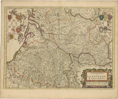
This stunning 1679 map of Portugal offers a captivating glimpse into the past, showcasing the country's geography as it was understood over three centuries ago. Spanning the entire western coast of the Iberian Peninsula, the map meticulously details regions such as Entre Douro e Minho, Beira, Estremadura, Alentejo, and the Algarve, each delineated with vibrant yellow and green borders. The Atlantic Ocean, labeled as "Oceano de Portugal" and "Tugal," frames the western edge, while the Gulf of Cadiz graces the southern boundary, adding a nautical allure to the composition. Intricate place names like Lisbon, Setubal, and Evora are scattered across the landscape, accompanied by a network of rivers, mountains, and towns, all rendered in delicate hand-colored lines and shading.
What makes this print particularly intriguing is its historical context and artistic execution. Created in an era when cartography was both a science and an art form, the map reflects the knowledge and exploration of the time, with some regions depicted with a charmingly approximate accuracy. The ornate cartouche in the upper right corner, adorned with a decorative drape and title "Parte Meridional do Reyno de Portugal," serves as a focal point, hinting at the map's royal patronage and its purpose as both a functional tool and a decorative piece. Red dots marking key locations add a touch of visual interest, drawing the eye across the terrain.
The map depicts the southern portion of Portugal, including:
Lisbon (Lisbonne) and the surrounding regions like Setúbal, Alentejo (ALEN), and the Ribatejo.
The Algarve region at the bottom, labeled "Reino do Algarve".
Border regions of Spain such as Andalusia and Extremadura.
Major rivers like the Tejo (Tagus) and Guadiana are prominently shown.
Cities such as Évora, Beja, Faro, Tavira, and Portalegre are labeled.
Coastal features like Cabo de São Vicente and Golfo de Cádiz are identified.
For a potential buyer, this map is a treasure trove of historical insight and aesthetic appeal. It offers a window into 18th-century Portugal, a period of maritime prowess and cultural richness, making it an ideal addition to a collection of antique maps or a study of European history. The aged parchment texture, combined with the hand-colored details, lends an authentic antique charm that modern reproductions struggle to replicate. Whether displayed in a study, library, or gallery, this map promises to spark conversations and admiration, blending educational value with timeless elegance.
Condition Summary
The print is in fair condition for its age, with some expected wear. There are no significant visible tears or losses, but a weaker area has been supported with archival tape on the reverse. The hand-colored elements remain vivid, and the text is legible, preserving the map's historical integrity.
Framing Tips
To preserve and showcase this print effectively, use acid-free matting and backing to protect the paper from further deterioration. A simple, elegant wooden frame in a neutral tone like walnut or oak will complement the map's antique style without overpowering it. Ensure the frame size allows for a generous border around the map to highlight its detailed edges and cartouche. Hang the print in a location away from direct sunlight and humidity to maintain its condition over time.
- Maße:Höhe: 42,5 cm (16,74 in)Breite: 57 cm (22,45 in)Tiefe: 0,2 mm (0,01 in)
- Materialien und Methoden:Papier,Graviert
- Herkunftsort:
- Zeitalter:Spätes 17. Jahrhundert
- Herstellungsjahr:1679
- Zustand:The print is in fair condition for its age, with some expected wear. There are no significant visible tears or losses, but a weaker area has been supported with archival tape on the reverse. The hand-colored elements remain vivid.
- Anbieterstandort:Langweer, NL
- Referenznummer:Anbieter*in: BG-14068-21stDibs: LU3054345401102
Anbieterinformationen
5,0
Anerkannte Anbieter*innen
Diese renommierten Anbieter*innen sind führend in der Branche und repräsentieren die höchste Klasse in Sachen Qualität und Design.
Gold-Anbieter*in
Premium-Anbieter*innen mit einer Bewertung über 4,3 und 24 Stunden Reaktionszeit
Gründungsjahr 2009
1stDibs-Anbieter*in seit 2017
2.467 Verkäufe auf 1stDibs
Typische Antwortzeit: 1 Stunde
- VersandAngebot wird abgerufen …Versand von: Langweer, Niederlande
- Rückgabebedingungen
Einige Inhalte dieser Seite wurden automatisch übersetzt. Daher kann 1stDibs nicht die Richtigkeit der Übersetzungen garantieren. Englisch ist die Standardsprache dieser Website.
Authentizitätsgarantie
Im unwahrscheinlichen Fall eines Problems mit der Echtheit eines Objekts kontaktieren Sie uns bitte innerhalb von 1 Jahr für eine volle Rückerstattung. DetailsGeld-Zurück-Garantie
Wenn Ihr Objekt nicht der Beschreibung entspricht, beim Transport beschädigt wurde oder nicht ankommt, kontaktieren Sie uns bitte innerhalb von 7 Tagen für eine vollständige Rückerstattung. DetailsStornierung innerhalb von 24 Stunden
Sie können Ihren Kauf jederzeit innerhalb von 24 Stunden stornieren, ohne jegliche Gründe dafür angeben zu müssen.Geprüfte Anbieter*innen
Unsere Anbieter*innen unterliegen strengen Dienstleistungs- und Qualitätsstandards, wodurch wir die Seriosität unserer Angebote gewährleisten können.Preisgarantie
Wenn Sie feststellen, dass ein*e Anbieter*in dasselbe Objekt anderswo zu einem niedrigeren Preis anbietet, werden wir den Preis entsprechend anpassen.Zuverlässige weltweite Lieferung
Unsere erstklassigen Versandunternehmen bieten spezielle Versandoptionen weltweit, einschließlich individueller Lieferung.Mehr von diesem*dieser Anbieter*in
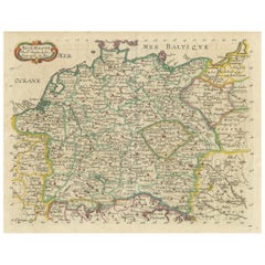
Alle anzeigenDekorative handkolorierte Karte von Deutschland von Nicolas Sanson, 1648
Titel: Handkolorierte Karte von Deutschland von Nicolas Sanson, 1648
Diese handkolorierte Karte mit dem Titel "Allemagne" wurde von Nicolas Sanson, einem bedeutenden französischen K...
Kategorie
Antik, 1640er, Landkarten
Materialien
Papier
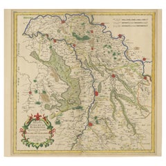
Antique Map of Roermond & Duchy of Guelders by Sanson – Hand-Colored, c.1667
Antique map of Roermond and the Duchy of Guelders with rich detail, c.1667
This beautifully hand-colored 17th-century map presents the region of Roermond and the broader Duchy of Gu...
Kategorie
Antik, Spätes 17. Jahrhundert, Französisch, Landkarten
Materialien
Papier
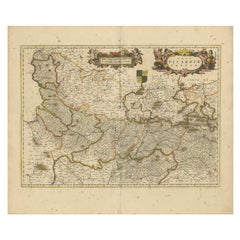
Picardy-Karte – handkolorierte Gravur des 17. Jahrhunderts von Frederik De Wit aus dem Jahr 1688
Titel: Picardie-Karte - Handkolorierter Kupferstich von Frederik De Wit aus dem 17. Jahrhundert um 1688
Beschreibung: Diese wunderschön detaillierte Karte, "Nova Picardiae Tabula", ...
Kategorie
Antik, 1680er, Landkarten
Materialien
Papier
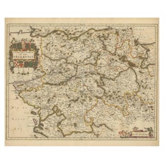
Handkolorierte Karte von Orléanais in Frankreich aus dem 17. Jahrhundert von Frederik De Wit, um 1688
Titel: Handkolorierte Karte von Orléanais aus dem 17. Jahrhundert von Frederik De Wit um 1688
Beschreibung: Diese schön gestaltete Karte "Gouvernement General du Pays Orléanois" zei...
Kategorie
Antik, 1680er, Landkarten
Materialien
Papier
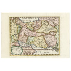
Karte des Persischen Reiches von Nicolas Sanson, handkoloriert, um 1683
Karte des Persischen Reiches von Nicolas Sanson, handkoloriert, um 1683
Diese fein detaillierte und zart handkolorierte Karte mit dem Titel *L'Empire du Sophy des Perses* zeigt eine...
Kategorie
Antik, 1680er, Landkarten
Materialien
Papier
Gascogne- und Guyenne-Karte – handkoloriertes Kupferstich aus dem 17. Jahrhundert von De Wit, um 1688
Titel: Karte der Gascogne und Guyenne - Handkolorierter Kupferstich von Frederik De Wit aus dem 17. Jahrhundert, um 1688
Beschreibung: Diese bemerkenswerte Karte, "Gouvernement de l...
Kategorie
Antik, 1680er, Landkarten
Materialien
Papier
Das könnte Ihnen auch gefallen
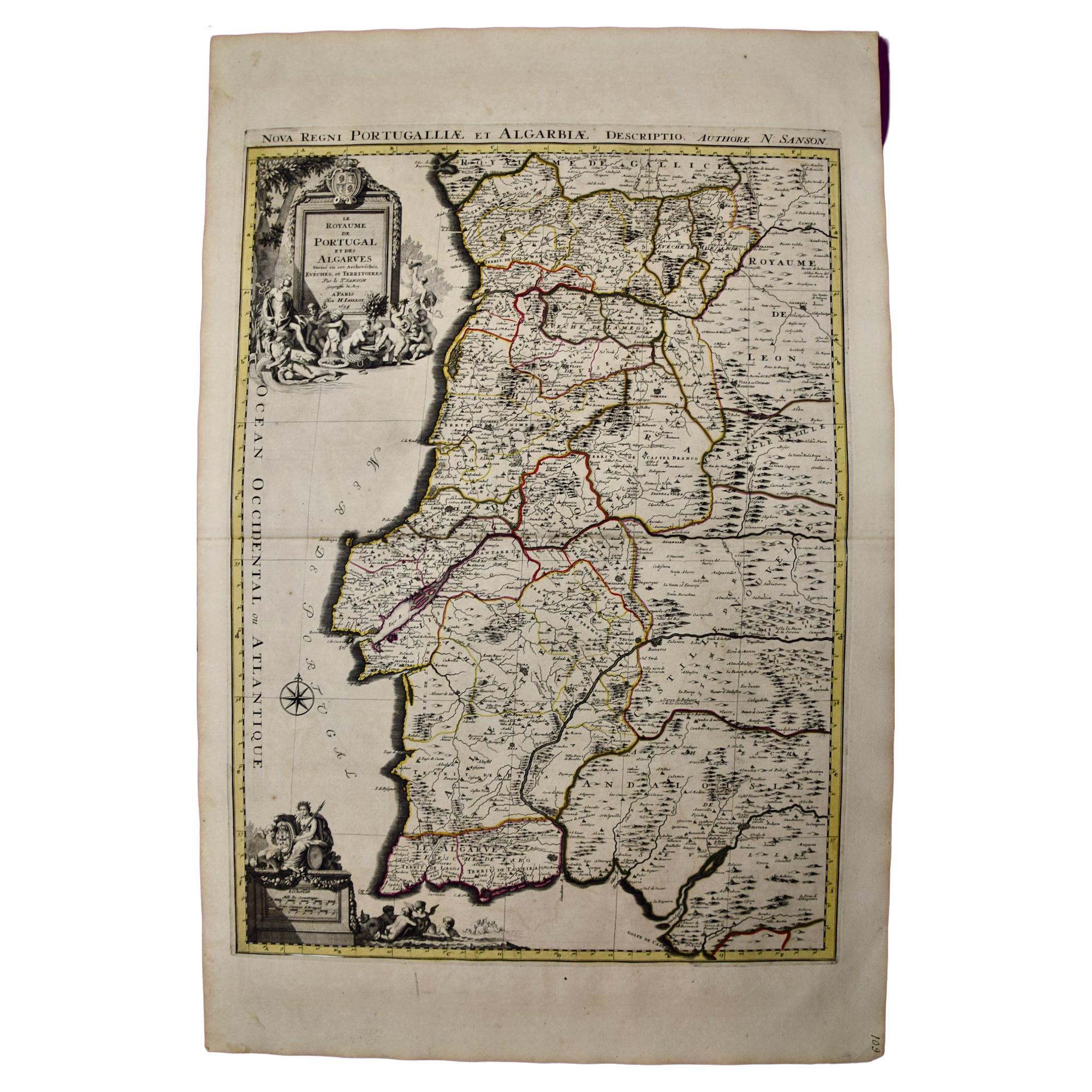
Portugal: Eine große handkolorierte Karte aus dem 17. Jahrhundert von Sanson und Jaillot
Von Nicolas Sanson
Diese große handkolorierte Karte mit dem Titel "Le Royaume de Portugal et des Algarves Divisee en see Archeveches, Eveches et Territoires Par le Sr Sanson" wurde ursprünglich von Nic...
Kategorie
Antik, 1690er, Französisch, Landkarten
Materialien
Papier

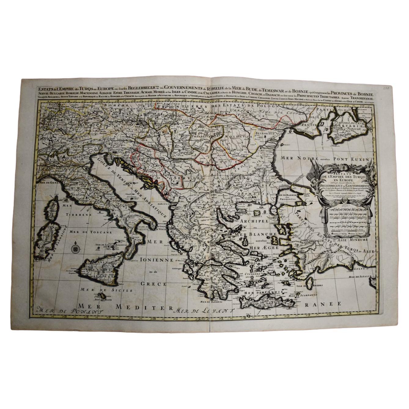
Süd- und Osteuropa: Eine große handkolorierte Karte aus dem 17. Jahrhundert von Sanson & Jaillot
Von Nicolas Sanson
Diese große handkolorierte Karte mit dem Titel "Estats de L'Empire des Turqs en Europe, ou sont les Beglerbeglicz our Gouvernements" wurde ursprünglich von Nicholas Sanson d'Abbevill...
Kategorie
Antik, 1690er, Französisch, Landkarten
Materialien
Papier

Southern Greece: Eine große handkolorierte Karte aus dem 17. Jahrhundert von Sanson und Jaillot
Von Nicolas Sanson
Diese große original handkolorierte Kupferstichkarte von Südgriechenland und der Halbinsel Peloponnes mit dem Titel "La Moree Et Les Isles De Zante, Cefalonie, Ste. Marie, Cerigo & C...
Kategorie
Antik, 1690er, Französisch, Landkarten
Materialien
Papier

""Africa Vetus"": eine handkolorierte Karte von Sanson aus dem 17. Jahrhundert
Von Nicolas Sanson
Diese originale handkolorierte Kupferstichkarte von Afrika mit dem Titel "Africa Vetus, Nicolai Sanson Christianiss Galliar Regis Geographi" wurde ursprünglich von Nicholas Sanson d'...
Kategorie
Antik, Spätes 17. Jahrhundert, Französisch, Landkarten
Materialien
Papier

Griechenland, „Graeciae Antiquae“ „“, handkolorierte Karte von Sanson aus dem 17. Jahrhundert
Von Nicolas Sanson
Dies ist eine original handkolorierte Kupferstichkarte von Griechenland aus dem 17. Jahrhundert mit dem Titel "Graeciae Antiquae Tabula Hanc Geographicam" von Nicolas d'Abbeville San...
Kategorie
Antik, Mitte 17. Jahrhundert, Französisch, Landkarten
Materialien
Papier

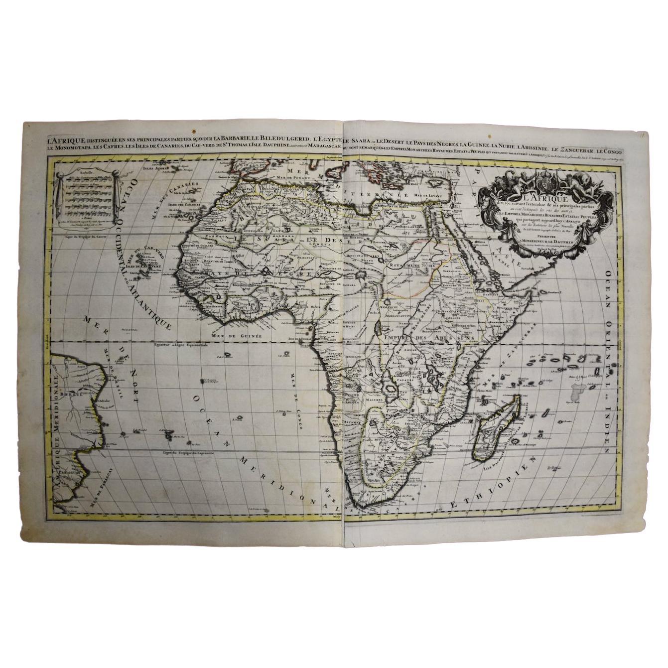
Afrika: Eine große handkolorierte Karte aus dem 17. Jahrhundert von Sanson und Jaillot
Von Nicolas Sanson
Diese große original handkolorierte Kupferstichkarte von Afrika mit dem Titel "L'Afrique divisee suivant l'estendue de ses principales parties ou sont distingues les uns des autres, ...
Kategorie
Antik, 1690er, Französisch, Landkarten
Materialien
Papier
