Objekte ähnlich wie Antique Map of Africa, Highlighting Colonial Divisions, Geographic Features 1903


Möchten Sie mehr Bilder oder Videos?
Zusätzliche Bilder oder Videos von dem*der Anbieter*in anfordern
1 von 10
Antique Map of Africa, Highlighting Colonial Divisions, Geographic Features 1903
Angaben zum Objekt
Title: Antique Map of Africa, 1903, Highlighting Colonial Divisions and Geographic Features
Description: This antique map, titled "Africa," was engraved and published in 1903 by W. & A.K. Johnston in Edinburgh and London. It provides a fascinating and detailed look at the African continent at the height of the colonial era, reflecting the complex interplay of geography, culture, and imperial ambitions.
Hand-colored in soft pastel shades, the map delineates the colonial territories that defined Africa during this period, including the spheres of influence of the British, French, German, Portuguese, Italian, Belgian, and Spanish empires. Major rivers, mountain ranges, and lakes are all clearly depicted, offering a rich geographical context for the colonial boundaries imposed by European powers.
The map’s elegant typography and refined linework capture the grandeur of Africa’s natural features and underscore the political realities of the time. From the Sahara Desert to the fertile Nile basin, from the Cape of Good Hope to the islands of the Indian Ocean, this map illustrates the diverse environments and cultures that make Africa such a dynamic and significant part of the world.
For collectors, historians, and those with an interest in African history, this map is more than a decorative piece—it is a testament to a pivotal period in the continent’s story, reflecting both the beauty of its landscapes and the dramatic changes brought by colonization.
Condition report:
This map is in very good antique condition, with only minor foxing and gentle edge toning typical for its age. The colors remain vibrant and the paper is stable and well-preserved.
Framing tips:
A classic wooden frame in walnut or cherry will enhance the soft pastel colors and historical detail of this map. Use a cream or off-white matting to highlight the refined linework and create a sophisticated, timeless focal point for any home, library, or study.
- Maße:Höhe: 36,8 cm (14,49 in)Breite: 47 cm (18,51 in)Tiefe: 0,2 mm (0,01 in)
- Materialien und Methoden:
- Zeitalter:
- Herstellungsjahr:1903
- Zustand:This map is in very good antique condition, with only minor foxing and gentle edge toning typical for its age. The colors remain vibrant and the paper is stable and well-preserved.
- Anbieterstandort:Langweer, NL
- Referenznummer:Anbieter*in: BG-13577-351stDibs: LU3054345271972
Anbieterinformationen
5,0
Anerkannte Anbieter*innen
Diese renommierten Anbieter*innen sind führend in der Branche und repräsentieren die höchste Klasse in Sachen Qualität und Design.
Gold-Anbieter*in
Premium-Anbieter*innen mit einer Bewertung über 4,3 und 24 Stunden Reaktionszeit
Gründungsjahr 2009
1stDibs-Anbieter*in seit 2017
2.463 Verkäufe auf 1stDibs
Typische Antwortzeit: <1 Stunde
- VersandAngebot wird abgerufen …Versand von: Langweer, Niederlande
- Rückgabebedingungen
Einige Inhalte dieser Seite wurden automatisch übersetzt. Daher kann 1stDibs nicht die Richtigkeit der Übersetzungen garantieren. Englisch ist die Standardsprache dieser Website.
Authentizitätsgarantie
Im unwahrscheinlichen Fall eines Problems mit der Echtheit eines Objekts kontaktieren Sie uns bitte innerhalb von 1 Jahr für eine volle Rückerstattung. DetailsGeld-Zurück-Garantie
Wenn Ihr Objekt nicht der Beschreibung entspricht, beim Transport beschädigt wurde oder nicht ankommt, kontaktieren Sie uns bitte innerhalb von 7 Tagen für eine vollständige Rückerstattung. DetailsStornierung innerhalb von 24 Stunden
Sie können Ihren Kauf jederzeit innerhalb von 24 Stunden stornieren, ohne jegliche Gründe dafür angeben zu müssen.Geprüfte Anbieter*innen
Unsere Anbieter*innen unterliegen strengen Dienstleistungs- und Qualitätsstandards, wodurch wir die Seriosität unserer Angebote gewährleisten können.Preisgarantie
Wenn Sie feststellen, dass ein*e Anbieter*in dasselbe Objekt anderswo zu einem niedrigeren Preis anbietet, werden wir den Preis entsprechend anpassen.Zuverlässige weltweite Lieferung
Unsere erstklassigen Versandunternehmen bieten spezielle Versandoptionen weltweit, einschließlich individueller Lieferung.Mehr von diesem*dieser Anbieter*in
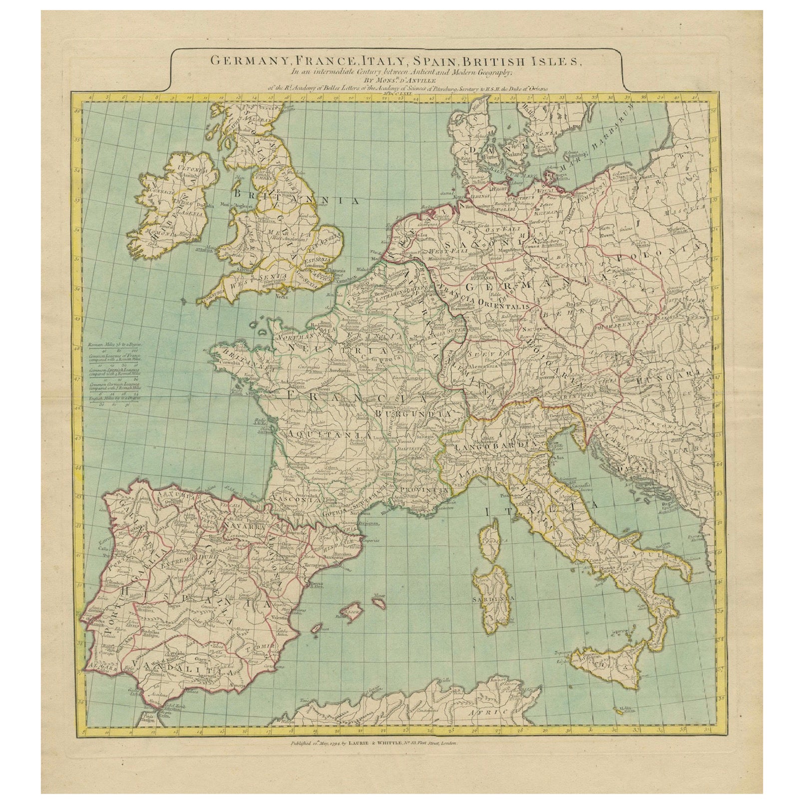
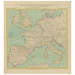
Alle anzeigenKarte von Europa mit Highlight der alten und modernen geografischen Einteilungen (1794)
Karte von Europa mit Hervorhebung der alten und modernen geografischen Unterteilungen (1794). Deutschland, Frankreich, Italien, Spanien und die britischen Inseln - Karte von D'Anvill...
Kategorie
Antik, 1790er, Landkarten
Materialien
Papier
1.572 $ Angebotspreis
20 % Rabatt
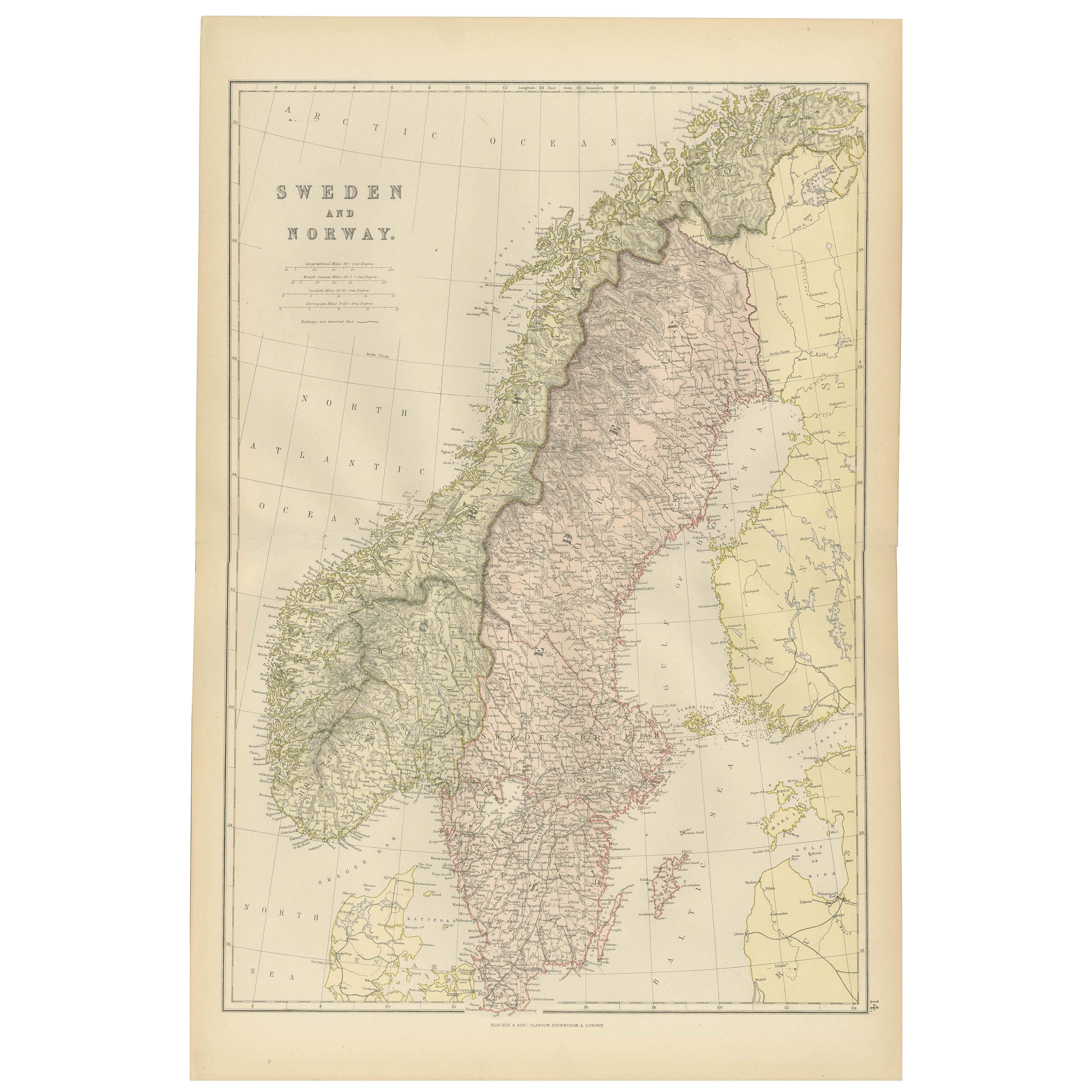
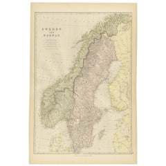
1882 Karte von Schweden und Norwegen mit geografischen und politischen Merkmalen
Diese Karte von Schweden und Norwegen aus dem Jahr 1882, die von Blackie and Son als Teil des "Comprehensive Atlas and Geography of the World" veröffentlicht wurde, bietet eine detai...
Kategorie
Antik, 1880er, Landkarten
Materialien
Papier
290 $
Kostenloser Versand
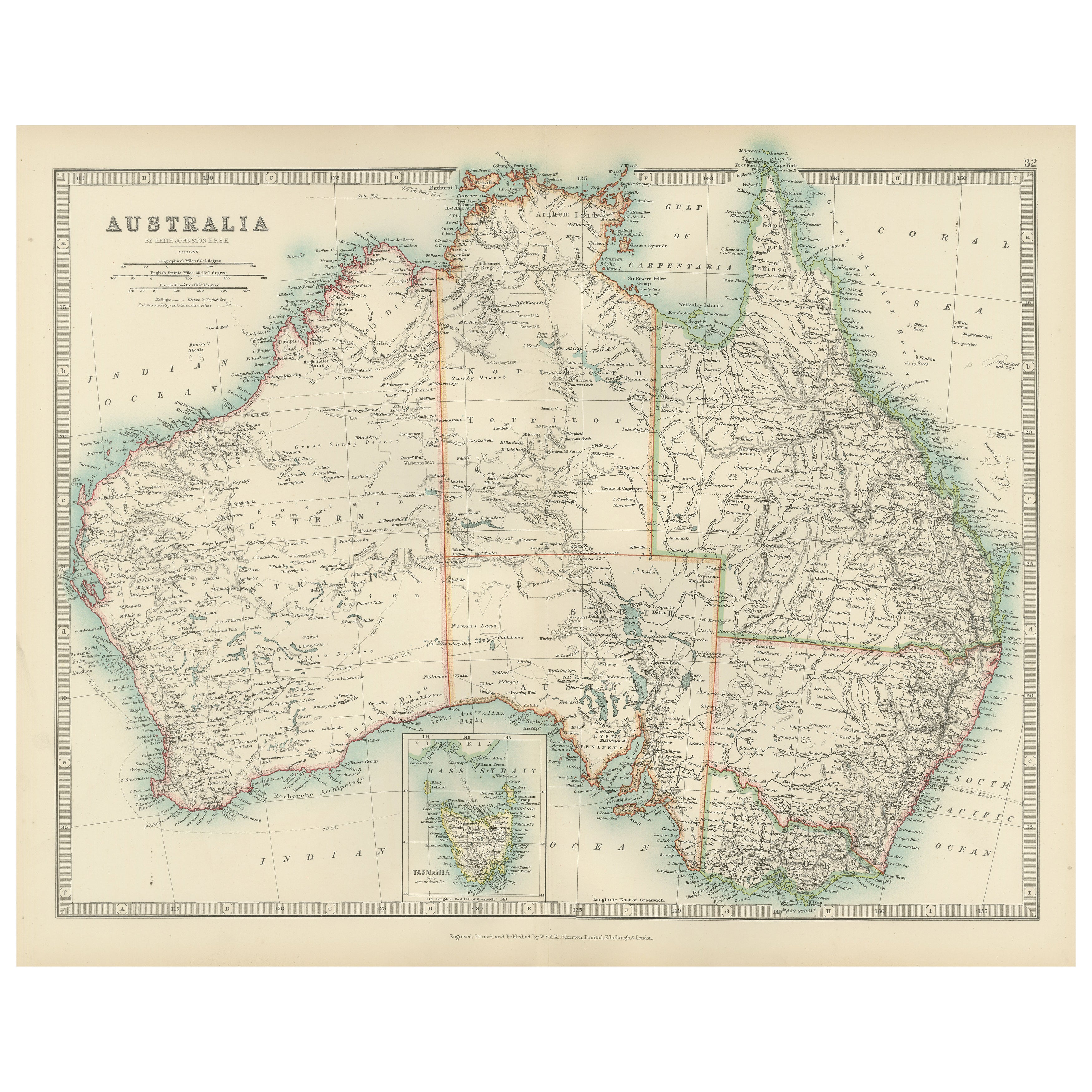
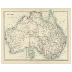
Antique Map of Australia, 1903, with Colonial Divisions and Detailed Topography
Title: Antique Map of Australia, 1903, with Colonial Divisions and Detailed Topography
Description: This antique map, titled "Australia," was engraved and published in 1903 by W. & ...
Kategorie
Frühes 20. Jahrhundert, Landkarten
Materialien
Papier
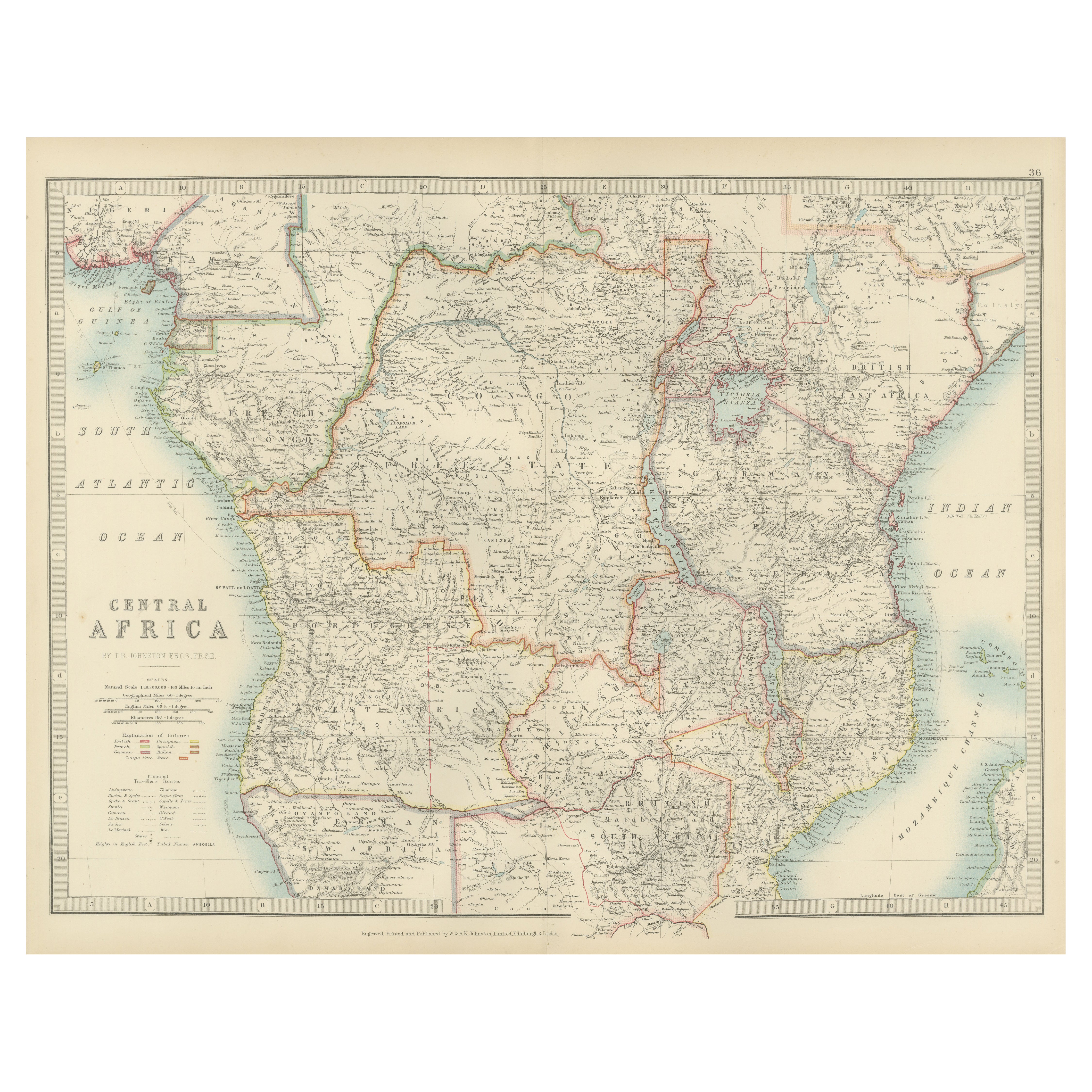
Antique Map of Central Africa, 1903, With Colonial Territories Explorers Routes
Antique Map of Central Africa, 1903, Featuring Colonial Territories and Explorers’ Routes
This antique map, titled "Central Africa," was engraved and published in 1903 by W. & A.K. ...
Kategorie
Frühes 20. Jahrhundert, Landkarten
Materialien
Papier

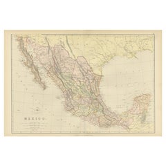
1882 Antike Karte von Mexiko mit Schwerpunkt auf geografischen und politischen Grenzen
Diese Karte von Mexiko aus dem Jahr 1882, die von Blackie and Son als Teil des "Comprehensive Atlas and Geography of the World" veröffentlicht wurde, bietet eine sehr detaillierte Da...
Kategorie
Antik, 1880er, Landkarten
Materialien
Papier
290 $
Kostenloser Versand
Antique Map of Northern Scotland, 1903, with Intricate Coastal Features
Title: Antique Map of Northern Scotland and Islands, 1903, with Intricate Coastal Features
Description:
This striking antique map, titled "Scotland (Northern Sheet I)," was engraved...
Kategorie
Frühes 20. Jahrhundert, Landkarten
Materialien
Papier

Das könnte Ihnen auch gefallen
Geographicalische antike Karte der Haupthauptstadt Monaco
Von Bruno Santini
ST/609 - Interessante antike farbige Karte des Fürstentums Monaco in französischer Sprache: "Carte qui contient le Principauté de Piémont, le Monferrat et la comté de Nice avec la Ri...
Kategorie
Antik, Spätes 18. Jahrhundert, Italienisch, Sonstiges, Landkarten
Materialien
Papier

Original Antike Karte des amerikanischen Staates Minnesota, 1903
Antike Karte von Minnesota
Veröffentlicht von A & C Black. 1903
Original Farbe
Guter Zustand
Ungerahmt.
Kostenloser Versand
Kategorie
Antik, Frühes 20. Jhdt., Englisch, Landkarten
Materialien
Papier

Original Antike Karte des amerikanischen Staates Alabama, 1903
Antique map of Alabama
Published By A & C Black. 1903
Original colour
Good condition
Unframed.
Free shipping
Kategorie
Antik, Frühes 20. Jhdt., Englisch, Landkarten
Materialien
Papier

Original Antike Karte des amerikanischen Staates Alaska, 1903
Antike Karte von Alaska
Veröffentlicht von A & C Black. 1903
Original Farbe
Guter Zustand
Ungerahmt.
Kostenloser Versand
Kategorie
Antik, Frühes 20. Jhdt., Englisch, Landkarten
Materialien
Papier

Original Antike Karte des amerikanischen Staates Nebraska, 1903
Antike Karte von Nebraska
Veröffentlicht von A & C Black. 1903
Original Farbe
Guter Zustand
Ungerahmt.
Kostenloser Versand
Kategorie
Antik, Frühes 20. Jhdt., Englisch, Landkarten
Materialien
Papier

Antike Karte des amerikanischen Staates Washington, 1903
Antike Karte von Washington
Veröffentlicht von A & C Black. 1903
Original Farbe
Guter Zustand
Ungerahmt.
Kostenloser Versand
Kategorie
Antik, Frühes 20. Jhdt., Englisch, Landkarten
Materialien
Papier
