Objekte ähnlich wie Antique Map of China, Taiwan, Korea, Hong-Kong and Japan, 1903


Möchten Sie mehr Bilder oder Videos?
Zusätzliche Bilder oder Videos von dem*der Anbieter*in anfordern
1 von 10
Antique Map of China, Taiwan, Korea, Hong-Kong and Japan, 1903
Angaben zum Objekt
Antique Map of China, Taiwan, Korea, Hong-Kong and Japan, 1903
Description: This antique map, titled "India (Southern Sheet) and the South Eastern Provinces," was engraved and published in 1903 by W. & A.K. Johnston in Edinburgh and London. It provides a beautiful and detailed depiction of the southern part of the Indian subcontinent and the southeastern provinces of what is now Myanmar (Burma).
The map is delicately colored in soft pastel shades to highlight provincial and regional boundaries, illustrating the rich geographical and cultural diversity of the region. Major cities, rivers, mountain ranges, and coastal features are marked with precision, reflecting the cartographic skill and artistry of Johnston’s team. The inset map of the South Eastern Provinces provides a closer look at the territories of Burma and its relationship to the Indian subcontinent.
This map captures the dynamic interplay between ancient cultures and British colonial influence at the turn of the 20th century, offering a fascinating window into an era of significant political and social change. The careful engraving and elegant typography make this map not just a historical document, but also a work of art that celebrates the beauty and complexity of southern Asia.
For collectors, historians, and lovers of Indian history and culture, this map is a testament to a time of exploration, trade, and cultural exchange, showcasing the enduring legacy of these lands at the crossroads of empires.
Condition report:
This map is in very good antique condition, with minor age-related foxing and gentle toning along the edges. The colors remain vibrant and the paper is stable and well-preserved.
Framing tips:
A classic wooden frame in walnut or cherry will enhance the warm pastel tones and intricate detailing of the map. Use a cream or off-white matting to highlight the refined linework and create a sophisticated, timeless focal point for any home, study, or library.
- Maße:Höhe: 36,8 cm (14,49 in)Breite: 47 cm (18,51 in)Tiefe: 0,2 mm (0,01 in)
- Materialien und Methoden:
- Zeitalter:
- Herstellungsjahr:1903
- Zustand:This map is in very good antique condition, with minor age-related foxing and gentle toning along the edges. The colors remain vibrant and the paper is stable and well-preserved. Folding line as issued.
- Anbieterstandort:Langweer, NL
- Referenznummer:Anbieter*in: BG-13577-301stDibs: LU3054345262602
Anbieterinformationen
5,0
Anerkannte Anbieter*innen
Diese renommierten Anbieter*innen sind führend in der Branche und repräsentieren die höchste Klasse in Sachen Qualität und Design.
Gold-Anbieter*in
Premium-Anbieter*innen mit einer Bewertung über 4,3 und 24 Stunden Reaktionszeit
Gründungsjahr 2009
1stDibs-Anbieter*in seit 2017
2.462 Verkäufe auf 1stDibs
Typische Antwortzeit: <1 Stunde
- VersandAngebot wird abgerufen …Versand von: Langweer, Niederlande
- Rückgabebedingungen
Einige Inhalte dieser Seite wurden automatisch übersetzt. Daher kann 1stDibs nicht die Richtigkeit der Übersetzungen garantieren. Englisch ist die Standardsprache dieser Website.
Authentizitätsgarantie
Im unwahrscheinlichen Fall eines Problems mit der Echtheit eines Objekts kontaktieren Sie uns bitte innerhalb von 1 Jahr für eine volle Rückerstattung. DetailsGeld-Zurück-Garantie
Wenn Ihr Objekt nicht der Beschreibung entspricht, beim Transport beschädigt wurde oder nicht ankommt, kontaktieren Sie uns bitte innerhalb von 7 Tagen für eine vollständige Rückerstattung. DetailsStornierung innerhalb von 24 Stunden
Sie können Ihren Kauf jederzeit innerhalb von 24 Stunden stornieren, ohne jegliche Gründe dafür angeben zu müssen.Geprüfte Anbieter*innen
Unsere Anbieter*innen unterliegen strengen Dienstleistungs- und Qualitätsstandards, wodurch wir die Seriosität unserer Angebote gewährleisten können.Preisgarantie
Wenn Sie feststellen, dass ein*e Anbieter*in dasselbe Objekt anderswo zu einem niedrigeren Preis anbietet, werden wir den Preis entsprechend anpassen.Zuverlässige weltweite Lieferung
Unsere erstklassigen Versandunternehmen bieten spezielle Versandoptionen weltweit, einschließlich individueller Lieferung.Mehr von diesem*dieser Anbieter*in
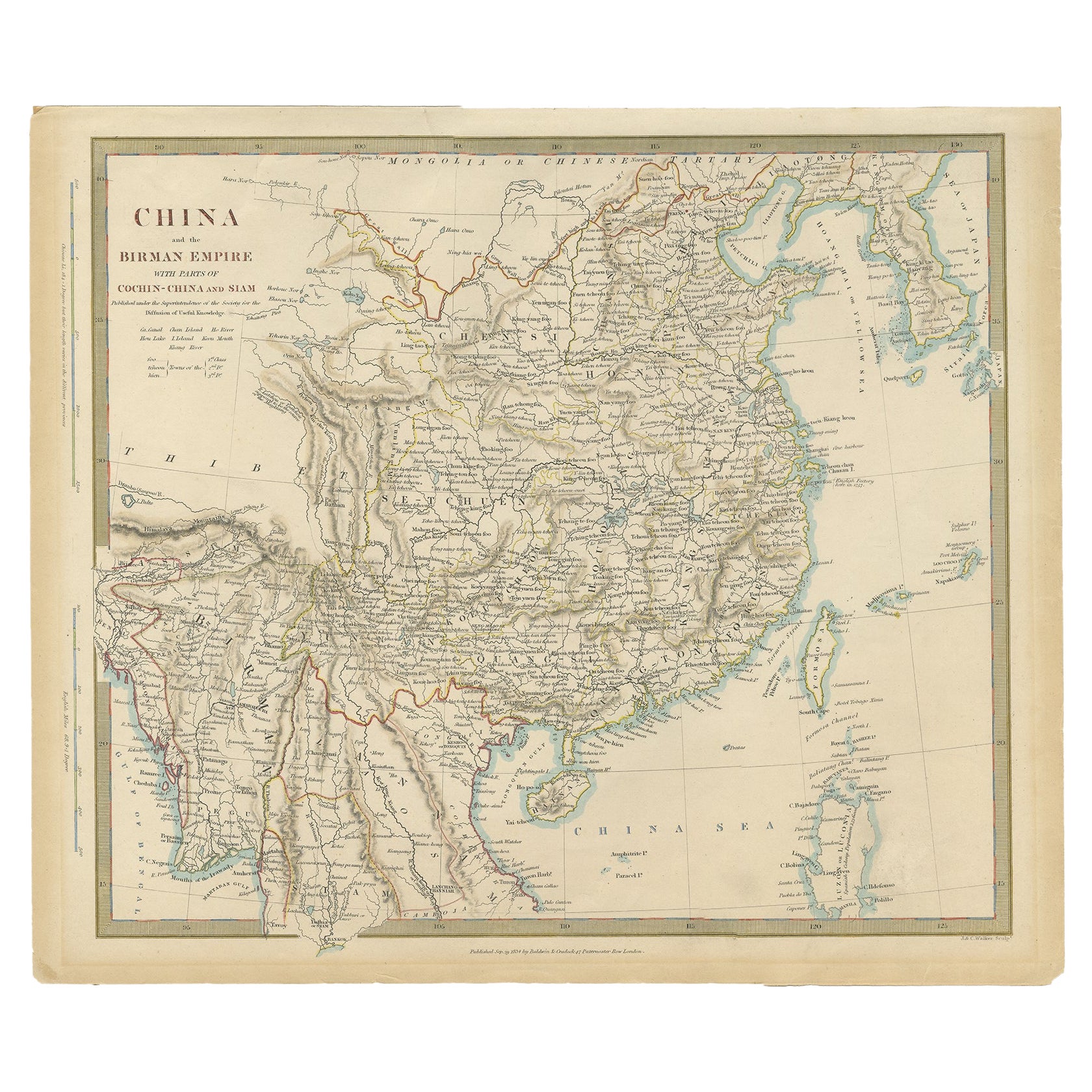
Alle anzeigenAntike Karte von China, einschließlich Korea und Taiwan, von Vaugondy, 1749
Antike Karte mit dem Titel 'Empire de la Chine'. Schöne Karte von China einschließlich Korea und Taiwan (Formosa). Diese Karte stammt aus dem "Atlas Universel (..)" von Gilles Robert...
Kategorie
Antik, Mitte des 18. Jahrhunderts, Landkarten
Materialien
Papier
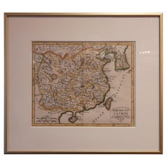
466 $ Angebotspreis
20 % Rabatt
Antike chinesische Karte, auch mit der Darstellung der Formosa „Taiwan“ und Teil Koreas, um 1840
Antike Karte mit dem Titel 'China'. Alte Karte von China, auf der auch Formosa (Taiwan) und ein Teil von Korea eingezeichnet sind. Quelle unbekannt, muss noch ermittelt werden.
Kü...
Kategorie
Antik, 19. Jahrhundert, Landkarten
Materialien
Papier
224 $ Angebotspreis
20 % Rabatt
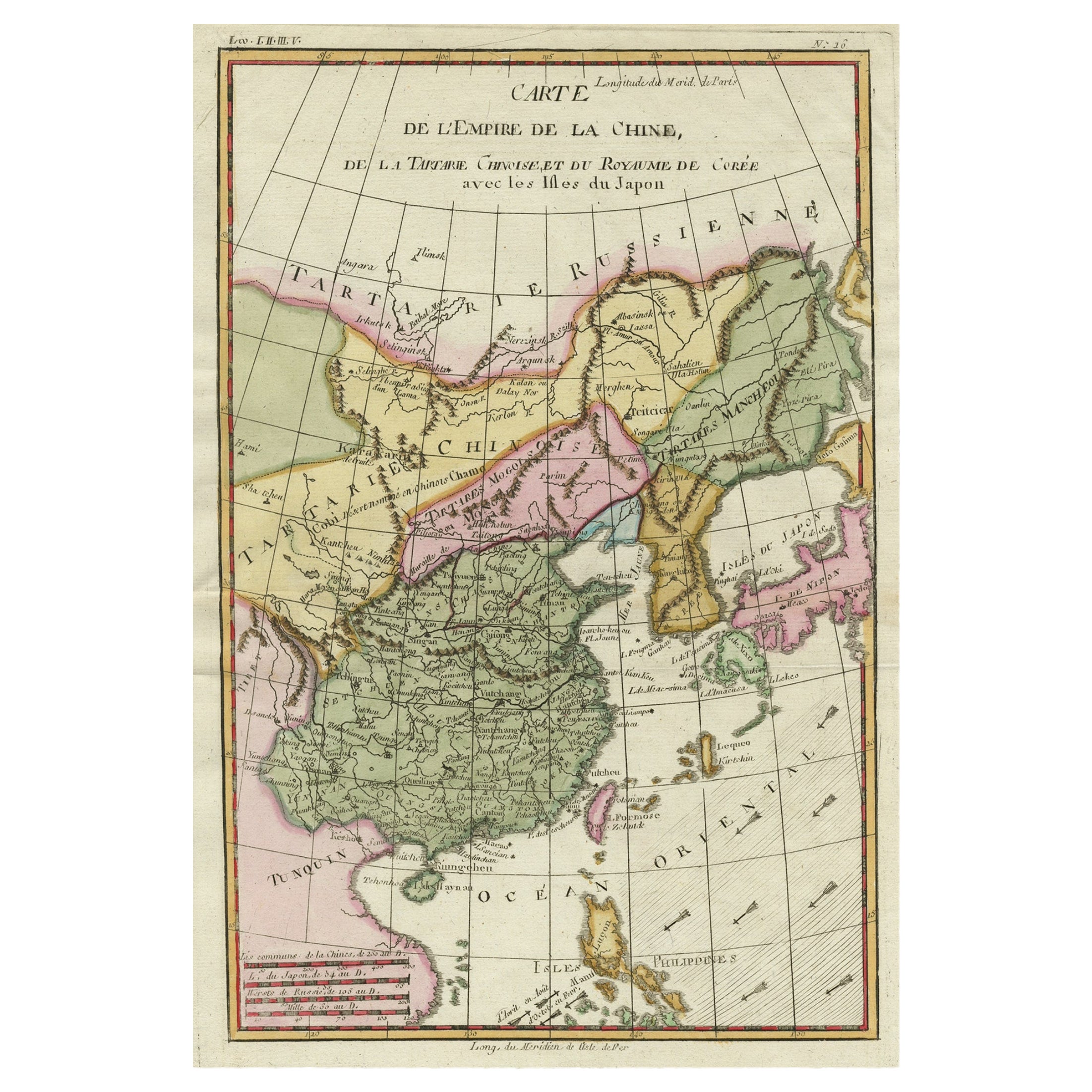
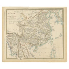
Dekorative Karte des Kaiserreichs von China, Korea, Japan, Taiwan, Lucon, Macau, 1780
Antike Karte mit dem Titel 'Carte de L'Empire de la Chine'
Dekorative Karte des Kaiserreichs China, die China, Corea (Korea), Japan, Tonquin und die philippinische Insel Lucon ze...
Kategorie
Antik, 1780er, Landkarten
Materialien
Papier
606 $ Angebotspreis
20 % Rabatt
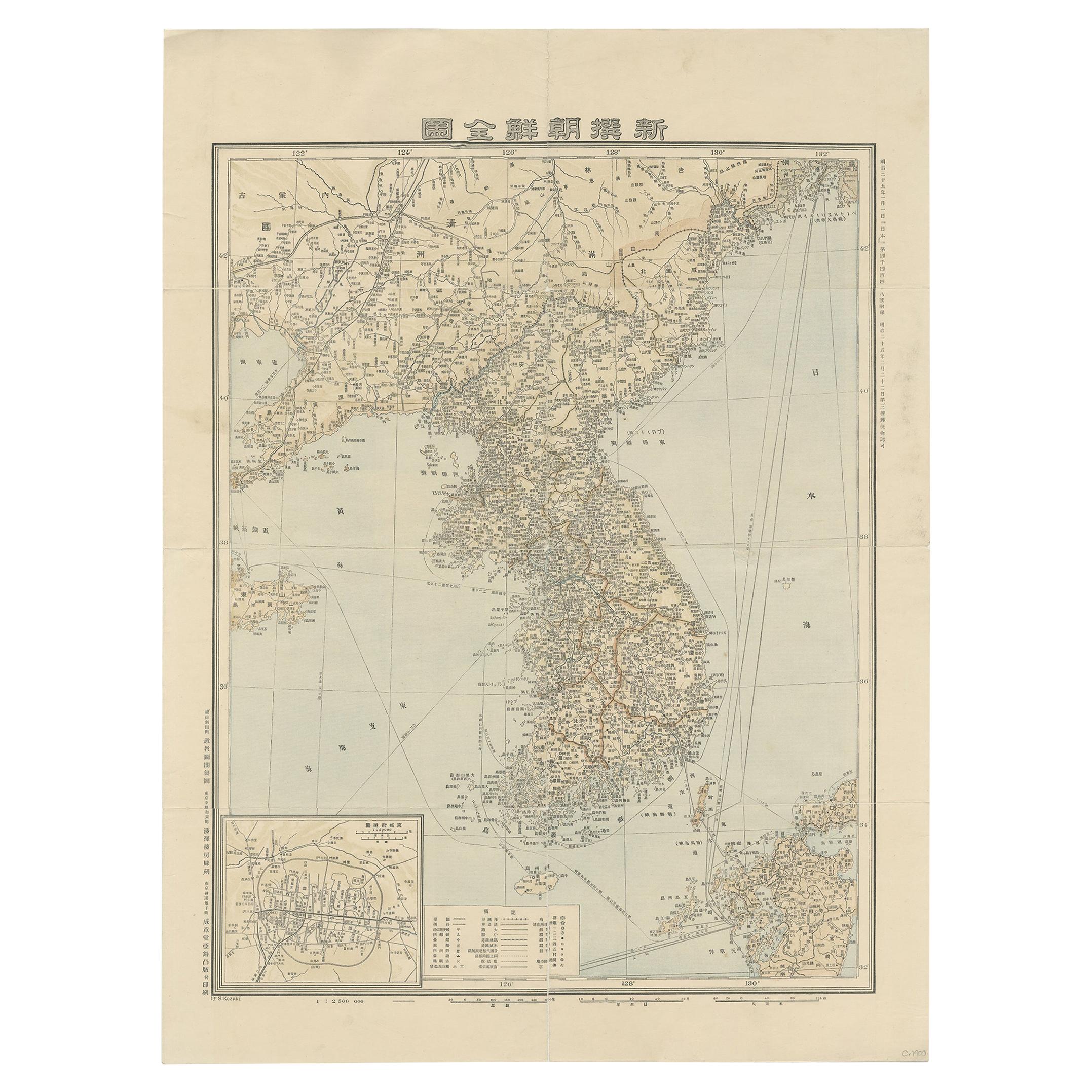
Antike Karte von Korea von Kozaki, 1903
Alte Karte von Korea von S. Kozaki. Restauriert und montiert.
Kategorie
20. Jahrhundert, Landkarten
Materialien
Papier

886 $ Angebotspreis
20 % Rabatt
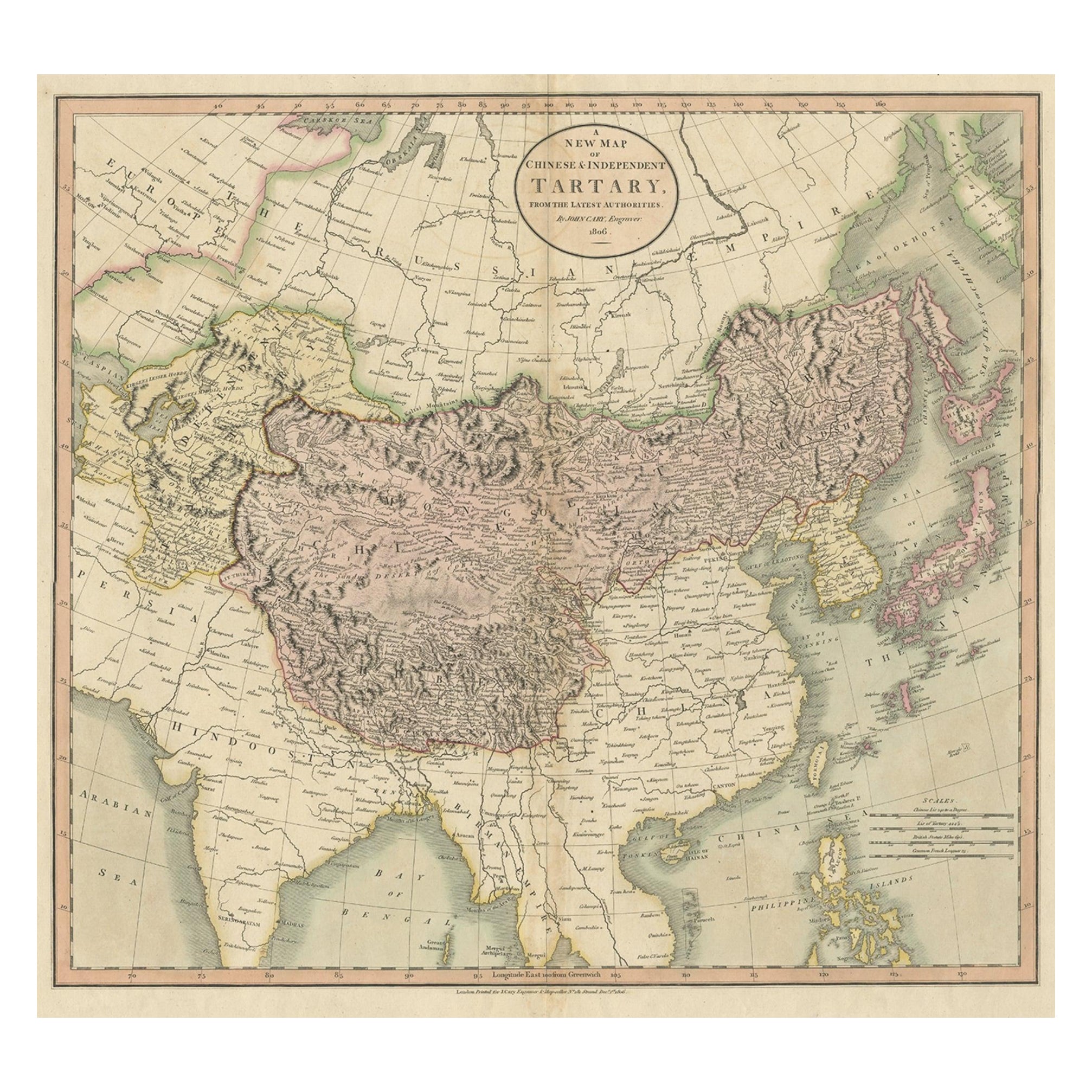
Antike Karte der chinesischen und unabhängigen Tartary, Korea und Japan, 1806
Antike Karte mit dem Titel 'A New Map of Chinese & Independent Tartary'. Schöne Karte von Chinesisch-Tartaren, Korea und Japan.
Künstler und Graveure: John Cary (1755-1835) war e...
Kategorie
Antik, 19. Jahrhundert, Landkarten
Materialien
Papier
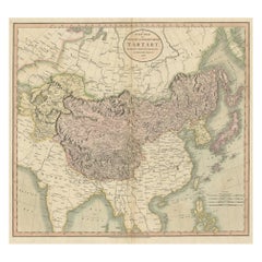
326 $ Angebotspreis
20 % Rabatt
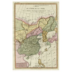
Antike Karte von China, Korea, Japan und den nördlichen Philippinen, um 1780
Antike Karte mit dem Titel "Carte de l'Empire de la Chine de la Tartarie Chinoise, et du Royaume de Corée". Interessante und detaillierte Karte von China, Korea, Japan und den nördli...
Kategorie
Antik, Spätes 18. Jahrhundert, Landkarten
Materialien
Papier

280 $ Angebotspreis
20 % Rabatt
Das könnte Ihnen auch gefallen
Sotheby's Hong Kong Wichtige Privatsammlung Chinesische Keramik Oct. 2019
Sotheby's Hongkong Wichtige Privatsammlung Chinesische Keramik 8. Oktober 2019. 1st Ed Hardcover. Dazu gehören seltene Beispiele von Ming- und Qing-Porzellan und mehrere außergewöhnl...
Kategorie
21. Jahrhundert und zeitgenössisch, Chinesisch, Bücher
Materialien
Papier
Original Antike Karte des amerikanischen Staates Minnesota, 1903
Antike Karte von Minnesota
Veröffentlicht von A & C Black. 1903
Original Farbe
Guter Zustand
Ungerahmt.
Kostenloser Versand
Kategorie
Antik, Frühes 20. Jhdt., Englisch, Landkarten
Materialien
Papier

Original Antike Karte des amerikanischen Staates Alabama, 1903
Antique map of Alabama
Published By A & C Black. 1903
Original colour
Good condition
Unframed.
Free shipping
Kategorie
Antik, Frühes 20. Jhdt., Englisch, Landkarten
Materialien
Papier

Original Antike Karte des amerikanischen Staates Alaska, 1903
Antike Karte von Alaska
Veröffentlicht von A & C Black. 1903
Original Farbe
Guter Zustand
Ungerahmt.
Kostenloser Versand
Kategorie
Antik, Frühes 20. Jhdt., Englisch, Landkarten
Materialien
Papier

Original Antike Karte des amerikanischen Staates Nebraska, 1903
Antike Karte von Nebraska
Veröffentlicht von A & C Black. 1903
Original Farbe
Guter Zustand
Ungerahmt.
Kostenloser Versand
Kategorie
Antik, Frühes 20. Jhdt., Englisch, Landkarten
Materialien
Papier

Antike Karte des amerikanischen Staates Washington, 1903
Antike Karte von Washington
Veröffentlicht von A & C Black. 1903
Original Farbe
Guter Zustand
Ungerahmt.
Kostenloser Versand
Kategorie
Antik, Frühes 20. Jhdt., Englisch, Landkarten
Materialien
Papier
