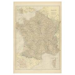
Objekte ähnlich wie Antique Map of France, 1903, with Inset of Paris and Corsica


Möchten Sie mehr Bilder oder Videos?
Zusätzliche Bilder oder Videos von dem*der Anbieter*in anfordern
1 von 10
Antique Map of France, 1903, with Inset of Paris and Corsica
Angaben zum Objekt
Title: Antique Map of France, 1903, with Inset of Paris and Corsica
Description:
This antique map, titled "France," was engraved and published in 1903 by the renowned W. & A.K. Johnston firm in Edinburgh and London. It offers a comprehensive and meticulously detailed view of France at the turn of the 20th century, capturing both its diverse geography and its political organization.
The map features an intricate network of departments, with boundaries delicately shaded in pastel greens, pinks, yellows, and blues, making each region stand out with subtle elegance. Cities, towns, rivers, and mountain ranges are finely rendered, showcasing the exceptional craftsmanship and precision that Johnston maps are known for.
A standout feature of this map is its inset detailing the "Environs of Paris," providing an in-depth view of the French capital and its surrounding area. Another inset focuses on the island of Corsica, ensuring no part of the French Republic is left undocumented. The clear, crisp typography and fine linework highlight the map’s quality, while the soft color palette adds a refined aesthetic that complements both modern and traditional interiors.
For collectors and enthusiasts, this map offers more than geographic data—it’s a snapshot of France at a time when the country was a leading European power with a rich cultural and political heritage. It also reflects a period of modernization, with railways connecting even the remotest parts of the nation.
Condition report:
The map is in very good antique condition, with minimal foxing and light edge toning typical for its age. The colors remain vibrant and the paper is stable and well-preserved.
Framing tips:
A dark wooden frame, such as walnut or mahogany, will add warmth and sophistication to this map. Use a cream or off-white matting to highlight the soft pastel colors and intricate detail, making this a refined and elegant focal point in any room or office.
- Maße:Höhe: 36,8 cm (14,49 in)Breite: 48 cm (18,9 in)Tiefe: 0,2 mm (0,01 in)
- Materialien und Methoden:
- Zeitalter:
- Herstellungsjahr:1903
- Zustand:The map is in very good antique condition, with minor age-related foxing and slight edge toning typical for its vintage. The colors remain vibrant and the paper is stable and well-preserved. Folding line as issued.
- Anbieterstandort:Langweer, NL
- Referenznummer:Anbieter*in: BG-13577-91stDibs: LU3054345241512
Anbieterinformationen
5,0
Anerkannte Anbieter*innen
Diese renommierten Anbieter*innen sind führend in der Branche und repräsentieren die höchste Klasse in Sachen Qualität und Design.
Gold-Anbieter*in
Premium-Anbieter*innen mit einer Bewertung über 4,3 und 24 Stunden Reaktionszeit
Gründungsjahr 2009
1stDibs-Anbieter*in seit 2017
2.462 Verkäufe auf 1stDibs
Typische Antwortzeit: <1 Stunde
- VersandAngebot wird abgerufen …Versand von: Langweer, Niederlande
- Rückgabebedingungen
Einige Inhalte dieser Seite wurden automatisch übersetzt. Daher kann 1stDibs nicht die Richtigkeit der Übersetzungen garantieren. Englisch ist die Standardsprache dieser Website.
Authentizitätsgarantie
Im unwahrscheinlichen Fall eines Problems mit der Echtheit eines Objekts kontaktieren Sie uns bitte innerhalb von 1 Jahr für eine volle Rückerstattung. DetailsGeld-Zurück-Garantie
Wenn Ihr Objekt nicht der Beschreibung entspricht, beim Transport beschädigt wurde oder nicht ankommt, kontaktieren Sie uns bitte innerhalb von 7 Tagen für eine vollständige Rückerstattung. DetailsStornierung innerhalb von 24 Stunden
Sie können Ihren Kauf jederzeit innerhalb von 24 Stunden stornieren, ohne jegliche Gründe dafür angeben zu müssen.Geprüfte Anbieter*innen
Unsere Anbieter*innen unterliegen strengen Dienstleistungs- und Qualitätsstandards, wodurch wir die Seriosität unserer Angebote gewährleisten können.Preisgarantie
Wenn Sie feststellen, dass ein*e Anbieter*in dasselbe Objekt anderswo zu einem niedrigeren Preis anbietet, werden wir den Preis entsprechend anpassen.Zuverlässige weltweite Lieferung
Unsere erstklassigen Versandunternehmen bieten spezielle Versandoptionen weltweit, einschließlich individueller Lieferung.Mehr von diesem*dieser Anbieter*in
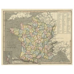
Alle anzeigenAntike Karte von Frankreich mit eingelassener Karte der Insel Korsika, 1820
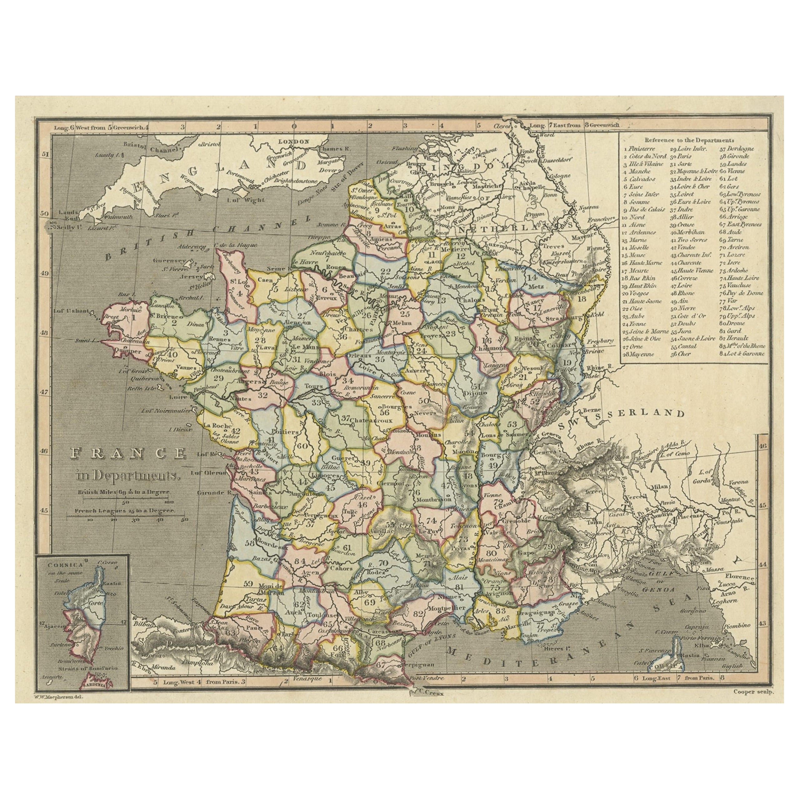
Antike Karte mit dem Titel 'Frankreich in Departements'. Alte Karte von Frankreich, mit einer kleinen Karte der Insel Korsika. Enthält eine Tabelle mit Verweisen auf die Abteilungen....
Kategorie
Antik, 19. Jahrhundert, Landkarten
Materialien
Papier
241 $ Angebotspreis
20 % Rabatt
Antike Karte von Frankreich mit einer eingelassenen Karte der Insel Korsika, um 1820
Antike Karte mit dem Titel 'Frankrijk naar de nieuwste bepalingen meerendeels gevolgd naar Lapie'. Schöne Karte von Frankreich mit einer Einlagekarte der Insel Korsika. Enthält eine ...
Kategorie
Antik, 19. Jahrhundert, Landkarten
Materialien
Papier

167 $ Angebotspreis
20 % Rabatt
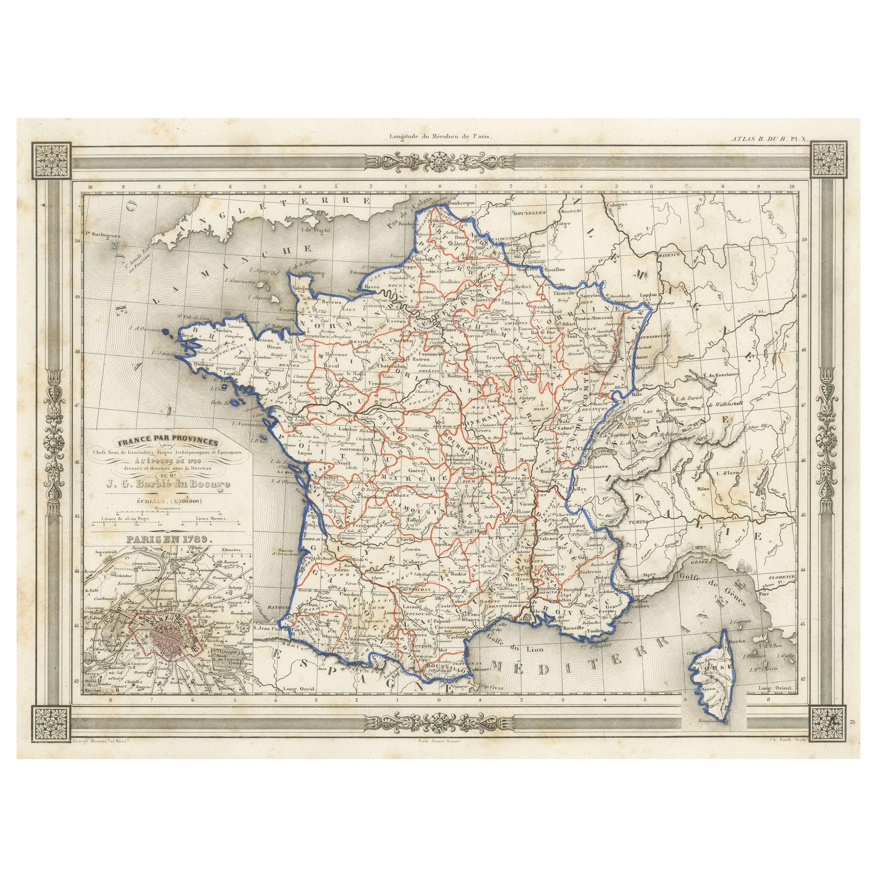
Antike Karte Frankreichs in Provinzen, mit Einlegearbeiten von Paris
Antike Karte mit dem Titel 'France par Provinces'. Original antike Karte von Frankreich in Provinzen. Es erstreckt sich von Flandern im Norden bis zum Roussillon im Süden und von der...
Kategorie
Antik, Mittleres 19. Jahrhundert, Landkarten
Materialien
Papier

102 $ Angebotspreis
20 % Rabatt
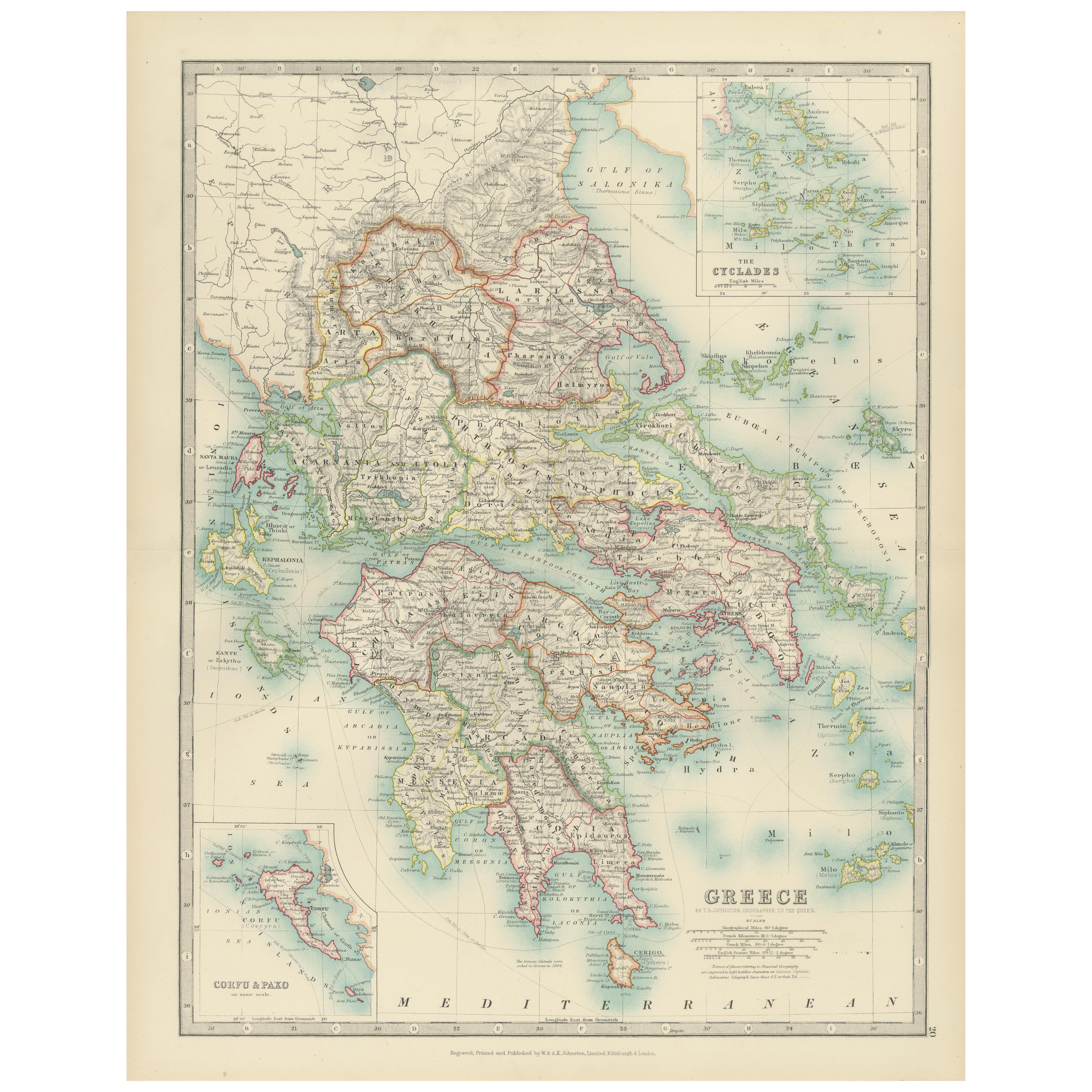
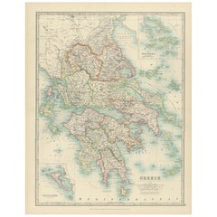
Antique Map of Greece and the Cyclades, 1903, with Many Details and Inset Maps
Title: Antique Map of Greece and the Cyclades, 1903, with Intricate Detail and Inset Maps
Description: This antique map, titled "Greece with Its Islands, Including the Cyclades," wa...
Kategorie
Frühes 20. Jahrhundert, Landkarten
Materialien
Papier
1882 Karte von Frankreich mit politischen Grenzen, Städten und Einschnitten aus Korsika
Diese Karte von Frankreich aus dem Jahr 1882, die von Blackie and Son als Teil des "Comprehensive Atlas and Geography of the World" veröffentlicht wurde, bietet eine detaillierte Dar...
Kategorie
Antik, 1880er, Landkarten
Materialien
Papier
290 $
Kostenloser Versand
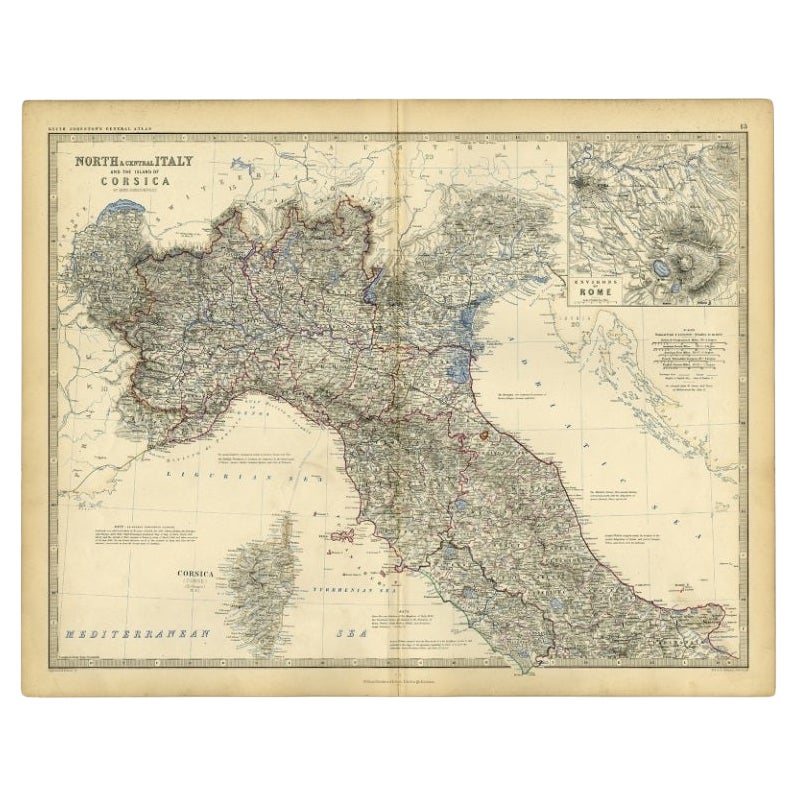
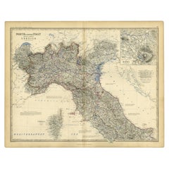
Antike Karte von Italien und Korsica, um 1860
Antike Karte mit dem Titel 'Nord- und Mittelitalien und die Insel Korsika'.
Alte Karte von Nord- und Mittelitalien und der Insel Korsika. Mit einer beigefügten Karte der Region R...
Kategorie
Antik, 19. Jahrhundert, Landkarten
Materialien
Papier
102 $ Angebotspreis
20 % Rabatt
Das könnte Ihnen auch gefallen
Original Antike Karte des amerikanischen Staates Minnesota, 1903
Antike Karte von Minnesota
Veröffentlicht von A & C Black. 1903
Original Farbe
Guter Zustand
Ungerahmt.
Kostenloser Versand
Kategorie
Antik, Frühes 20. Jhdt., Englisch, Landkarten
Materialien
Papier

Original Antike Karte des amerikanischen Staates Alabama, 1903
Antique map of Alabama
Published By A & C Black. 1903
Original colour
Good condition
Unframed.
Free shipping
Kategorie
Antik, Frühes 20. Jhdt., Englisch, Landkarten
Materialien
Papier

Original Antike Karte des amerikanischen Staates Alaska, 1903
Antike Karte von Alaska
Veröffentlicht von A & C Black. 1903
Original Farbe
Guter Zustand
Ungerahmt.
Kostenloser Versand
Kategorie
Antik, Frühes 20. Jhdt., Englisch, Landkarten
Materialien
Papier

Original Antike Karte des amerikanischen Staates Nebraska, 1903
Antike Karte von Nebraska
Veröffentlicht von A & C Black. 1903
Original Farbe
Guter Zustand
Ungerahmt.
Kostenloser Versand
Kategorie
Antik, Frühes 20. Jhdt., Englisch, Landkarten
Materialien
Papier

Antike Karte des amerikanischen Staates Washington, 1903
Antike Karte von Washington
Veröffentlicht von A & C Black. 1903
Original Farbe
Guter Zustand
Ungerahmt.
Kostenloser Versand
Kategorie
Antik, Frühes 20. Jhdt., Englisch, Landkarten
Materialien
Papier

Original Antike Karte des amerikanischen Staates Tennessee, 1903
Antique map of Tennessee
Published By A & C Black. 1903
Original colour
Good condition
Unframed.
Free shipping
Kategorie
Antik, Frühes 20. Jhdt., Englisch, Landkarten
Materialien
Papier
