Objekte ähnlich wie Antique Map of Oceania, 1903, Featuring the Pacific Islands and Australasia


Möchten Sie mehr Bilder oder Videos?
Zusätzliche Bilder oder Videos von dem*der Anbieter*in anfordern
1 von 10
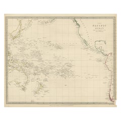
Antique Map of Oceania, 1903, Featuring the Pacific Islands and Australasia
Angaben zum Objekt
Title: Antique Map of Oceania, 1903, Featuring the Pacific Islands and Australasian Region
Description:
This antique map, titled "Oceania," was engraved and published in 1903 by W. & A.K. Johnston in Edinburgh and London. It provides a comprehensive and visually captivating depiction of the vast and culturally diverse region that includes the islands of the Pacific Ocean, as well as Australia and New Zealand.
Hand-colored in soft pastel shades, the map highlights the political and geographical boundaries of the region at the turn of the 20th century. The major landmasses of Australia, New Zealand, and the Indonesian archipelago are rendered with careful detail, while the islands of Micronesia, Melanesia, and Polynesia—scattered across the Pacific—are marked with precision and clarity.
This map captures not just the geography, but also the maritime networks and colonial ambitions that defined the region at the dawn of the modern era. Trade routes, ocean currents, and key ports are included, emphasizing the interconnectedness of these far-flung lands with the broader world.
For collectors, historians, and those with a passion for the history of exploration and the rich cultures of the Pacific, this map is a window into a time when distant islands and ancient cultures were coming into closer contact with the rest of the globe. The refined engraving and soft colors of the map also make it a striking decorative piece.
Condition report:
This map is in very good antique condition, with minor foxing and gentle edge toning typical for its age. The colors remain vibrant and the paper is stable and well-preserved.
Framing tips:
A classic dark wood frame in walnut or cherry will enhance the pastel colors and maritime elegance of the map. Use a cream or off-white matting to highlight the intricate linework and create a sophisticated, timeless focal point in any home, study, or library.
- Maße:Höhe: 36,8 cm (14,49 in)Breite: 47 cm (18,51 in)Tiefe: 0,2 mm (0,01 in)
- Materialien und Methoden:
- Zeitalter:
- Herstellungsjahr:1903
- Zustand:This map is in very good antique condition, with minor foxing and gentle edge toning typical for its age. The colors remain vibrant and the paper is stable and well-preserved. Folding line as issued.
- Anbieterstandort:Langweer, NL
- Referenznummer:Anbieter*in: BG-13577-311stDibs: LU3054345262762
Anbieterinformationen
5,0
Anerkannte Anbieter*innen
Diese renommierten Anbieter*innen sind führend in der Branche und repräsentieren die höchste Klasse in Sachen Qualität und Design.
Gold-Anbieter*in
Premium-Anbieter*innen mit einer Bewertung über 4,3 und 24 Stunden Reaktionszeit
Gründungsjahr 2009
1stDibs-Anbieter*in seit 2017
2.467 Verkäufe auf 1stDibs
Typische Antwortzeit: 1 Stunde
- VersandAngebot wird abgerufen …Versand von: Langweer, Niederlande
- Rückgabebedingungen
Einige Inhalte dieser Seite wurden automatisch übersetzt. Daher kann 1stDibs nicht die Richtigkeit der Übersetzungen garantieren. Englisch ist die Standardsprache dieser Website.
Authentizitätsgarantie
Im unwahrscheinlichen Fall eines Problems mit der Echtheit eines Objekts kontaktieren Sie uns bitte innerhalb von 1 Jahr für eine volle Rückerstattung. DetailsGeld-Zurück-Garantie
Wenn Ihr Objekt nicht der Beschreibung entspricht, beim Transport beschädigt wurde oder nicht ankommt, kontaktieren Sie uns bitte innerhalb von 7 Tagen für eine vollständige Rückerstattung. DetailsStornierung innerhalb von 24 Stunden
Sie können Ihren Kauf jederzeit innerhalb von 24 Stunden stornieren, ohne jegliche Gründe dafür angeben zu müssen.Geprüfte Anbieter*innen
Unsere Anbieter*innen unterliegen strengen Dienstleistungs- und Qualitätsstandards, wodurch wir die Seriosität unserer Angebote gewährleisten können.Preisgarantie
Wenn Sie feststellen, dass ein*e Anbieter*in dasselbe Objekt anderswo zu einem niedrigeren Preis anbietet, werden wir den Preis entsprechend anpassen.Zuverlässige weltweite Lieferung
Unsere erstklassigen Versandunternehmen bieten spezielle Versandoptionen weltweit, einschließlich individueller Lieferung.Mehr von diesem*dieser Anbieter*in
Alle anzeigenAntique Map of Italy, 1903, Featuring Islands of Sardinia and Sicily
Title: Antique Map of Italy, 1903, Featuring Islands of Sardinia and Sicily
Description:
This finely detailed antique map, titled "Italy," was engraved and published in 1903 by the ...
Kategorie
Frühes 20. Jahrhundert, Landkarten
Materialien
Papier
Antique Map of New Zealand, 1903, Featuring the North and South Islands and Alps
Title: Antique Map of New Zealand, 1903, Featuring the North and South Islands and the Southern Alps
Description:
This antique map, titled "New Zealand," was engraved and published ...
Kategorie
Frühes 20. Jahrhundert, Landkarten
Materialien
Papier

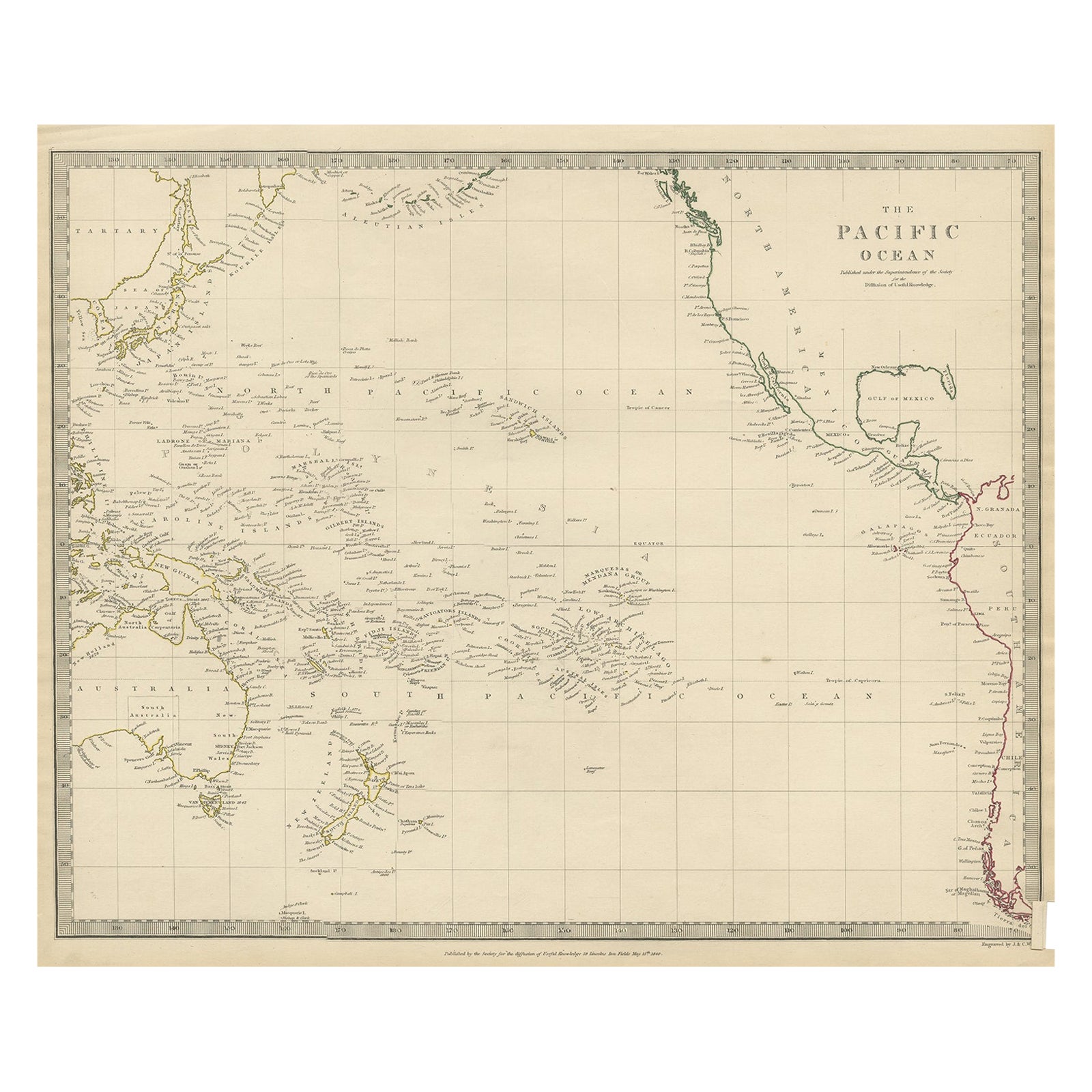
Antike Karte von Australasia, Neuseeland, Polynesien und dem Pazifischen Ozean, 1840
Antike Karte mit dem Titel 'Der Pazifische Ozean'.
Diese Karte zeigt Australasien, Neuseeland, Polynesien und die Inseln im Pazifischen Ozean einschließlich der Sandwichinseln.
...
Kategorie
Antik, 1840er, Landkarten
Materialien
Abalone, Papier
204 $ Angebotspreis
20 % Rabatt
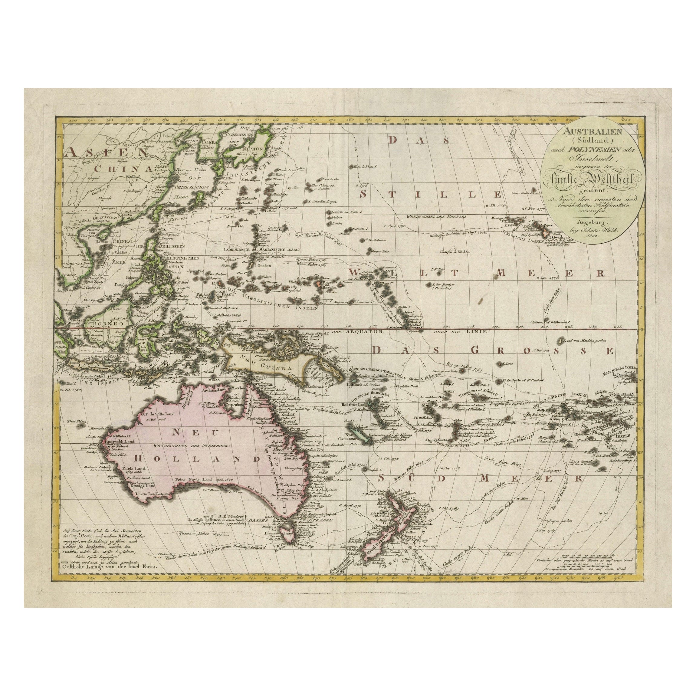
Map of Australasia and the South Pacific – European Exploration Routes aus dem Jahr 1802
1802 Johann Walch Karte von Australasien und dem Südpazifik - Europäische Entdeckungsrouten
Diese Karte von Johann Walch aus dem Jahr 1802 bietet eine sehr detaillierte Ansicht von ...
Kategorie
Antik, Anfang 1800, Landkarten
Materialien
Papier
1.676 $ Angebotspreis
20 % Rabatt
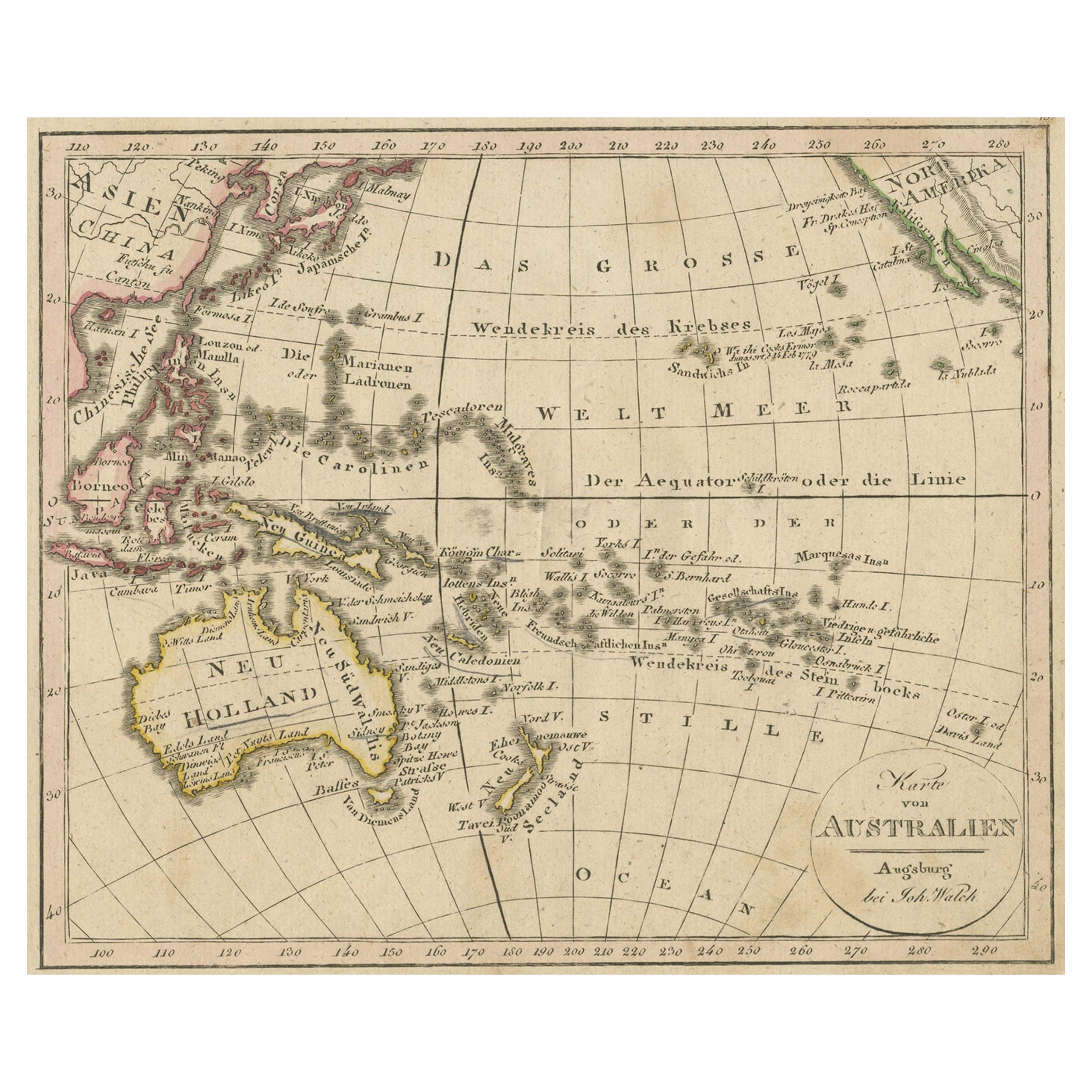
Antike Karte von Ozeanien und dem pazifischen Ozean, Australien und Neuseeland, 1826
Antike Karte von Australien mit dem Titel 'Karte von Australien'. Alte Karte von Australien und Neuseeland. Veröffentlicht in Walchs 'Neuer Schul-Atlas'.
Künstler und Graveure: J...
Kategorie
Antik, 19. Jahrhundert, Landkarten
Materialien
Papier
149 $ Angebotspreis
20 % Rabatt
Antike Karte der Inseln im pazifischen Ozean von Wyld, „1845“
Antike Karte mit dem Titel "Inseln im Pazifischen Ozean". Original antike Karte der Inseln im Pazifischen Ozean. Diese Karte stammt aus "An Atlas of the World, Comprehending Separate...
Kategorie
Antik, Mittleres 19. Jahrhundert, Landkarten
Materialien
Papier

186 $ Angebotspreis
20 % Rabatt
Das könnte Ihnen auch gefallen
Original Antike Karte des amerikanischen Staates Connecticut und Rhode Island, 1903
Antique map of Connecticut and Rhode Island
Published By A & C Black. 1903
Original colour
Good condition
Unframed.
Free shipping
Kategorie
Antik, Frühes 20. Jhdt., Englisch, Landkarten
Materialien
Papier

49 $
Kostenloser Versand
Große Original-Vintage-Karte der pazifischen Inseln, einschließlich Hawaii
Große Karte der Pazifischen Inseln
Ungerahmt
Original Farbe
Von John Bartholomew und Co. Geographisches Institut Edinburgh
Veröffentlicht, um 1920
Kostenloser Versand.
Kategorie
Vintage, 1920er, Britisch, Landkarten
Materialien
Papier

Original Antike Karte des amerikanischen Staates Minnesota, 1903
Antike Karte von Minnesota
Veröffentlicht von A & C Black. 1903
Original Farbe
Guter Zustand
Ungerahmt.
Kostenloser Versand
Kategorie
Antik, Frühes 20. Jhdt., Englisch, Landkarten
Materialien
Papier

Original Antike Karte des amerikanischen Staates Alabama, 1903
Antique map of Alabama
Published By A & C Black. 1903
Original colour
Good condition
Unframed.
Free shipping
Kategorie
Antik, Frühes 20. Jhdt., Englisch, Landkarten
Materialien
Papier

Original Antike Karte des amerikanischen Staates Alaska, 1903
Antike Karte von Alaska
Veröffentlicht von A & C Black. 1903
Original Farbe
Guter Zustand
Ungerahmt.
Kostenloser Versand
Kategorie
Antik, Frühes 20. Jhdt., Englisch, Landkarten
Materialien
Papier

Original Antike Karte des amerikanischen Staates Nebraska, 1903
Antike Karte von Nebraska
Veröffentlicht von A & C Black. 1903
Original Farbe
Guter Zustand
Ungerahmt.
Kostenloser Versand
Kategorie
Antik, Frühes 20. Jhdt., Englisch, Landkarten
Materialien
Papier
