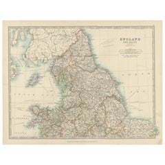
Objekte ähnlich wie Antique Map of Southern England & Wales, 1903, with Coastal Details and Railways


Möchten Sie mehr Bilder oder Videos?
Zusätzliche Bilder oder Videos von dem*der Anbieter*in anfordern
1 von 10
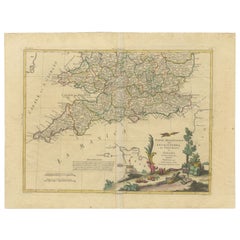
Antique Map of Southern England & Wales, 1903, with Coastal Details and Railways
Angaben zum Objekt
Title: Antique Map of Southern England and Wales, 1903, with Coastal Details and Railways
Description:
This detailed antique map, titled "England and Wales (Southern Sheet I)," was engraved and published in 1903 by W. & A.K. Johnston in Edinburgh and London. It offers a fascinating and intricate depiction of the southern part of England and Wales, showcasing counties, cities, towns, and natural features with exceptional clarity and artistry.
The map features the vibrant regions of Southern England, including Devon, Cornwall, Somerset, and the bustling metropolis of London. It also extends to Wales, highlighting the rugged coastline along the Bristol Channel and the scenic beauty of the English Channel. The fine engraving and subtle pastel coloring—using shades of green, pink, and yellow—create a refined and harmonious composition that brings this historical period to life.
One of the map’s highlights is its inclusion of the Scilly Islands in a dedicated inset, emphasizing their geographical and navigational importance. Extensive railway lines are meticulously marked, a testament to the region’s burgeoning industrial development and the vital role of rail transport in connecting towns and fostering economic growth during this transformative period.
For collectors and history enthusiasts, this map is not only a decorative statement but also a window into the geography and infrastructure of the United Kingdom at the beginning of the 20th century. It reflects an era of rapid modernization and urban expansion while preserving the rich character of the British landscape.
Condition report:
This map is in very good antique condition, with slight toning around the edges and minor foxing consistent with its age. The colors remain vibrant and the paper stable and intact.
Framing tips:
Select a traditional wooden frame in walnut or oak to complement the map’s historic charm. Use a cream or light tan matting to highlight the pastel coloring and intricate engraving, ensuring the map stands out as a sophisticated and elegant addition to any room.
- Maße:Höhe: 36,8 cm (14,49 in)Breite: 48 cm (18,9 in)Tiefe: 0,2 mm (0,01 in)
- Materialien und Methoden:
- Zeitalter:
- Herstellungsjahr:1903
- Zustand:This map is in very good antique condition, with slight toning around the edges and minor foxing consistent with its age. The colors remain vibrant and the paper stable and intact. Folding line as issued.
- Anbieterstandort:Langweer, NL
- Referenznummer:Anbieter*in: BG-13577-51stDibs: LU3054345241052
Anbieterinformationen
5,0
Anerkannte Anbieter*innen
Diese renommierten Anbieter*innen sind führend in der Branche und repräsentieren die höchste Klasse in Sachen Qualität und Design.
Gold-Anbieter*in
Premium-Anbieter*innen mit einer Bewertung über 4,3 und 24 Stunden Reaktionszeit
Gründungsjahr 2009
1stDibs-Anbieter*in seit 2017
2.452 Verkäufe auf 1stDibs
Typische Antwortzeit: <1 Stunde
- VersandAngebot wird abgerufen …Versand von: Langweer, Niederlande
- Rückgabebedingungen
Einige Inhalte dieser Seite wurden automatisch übersetzt. Daher kann 1stDibs nicht die Richtigkeit der Übersetzungen garantieren. Englisch ist die Standardsprache dieser Website.
Authentizitätsgarantie
Im unwahrscheinlichen Fall eines Problems mit der Echtheit eines Objekts kontaktieren Sie uns bitte innerhalb von 1 Jahr für eine volle Rückerstattung. DetailsGeld-Zurück-Garantie
Wenn Ihr Objekt nicht der Beschreibung entspricht, beim Transport beschädigt wurde oder nicht ankommt, kontaktieren Sie uns bitte innerhalb von 7 Tagen für eine vollständige Rückerstattung. DetailsStornierung innerhalb von 24 Stunden
Sie können Ihren Kauf jederzeit innerhalb von 24 Stunden stornieren, ohne jegliche Gründe dafür angeben zu müssen.Geprüfte Anbieter*innen
Unsere Anbieter*innen unterliegen strengen Dienstleistungs- und Qualitätsstandards, wodurch wir die Seriosität unserer Angebote gewährleisten können.Preisgarantie
Wenn Sie feststellen, dass ein*e Anbieter*in dasselbe Objekt anderswo zu einem niedrigeren Preis anbietet, werden wir den Preis entsprechend anpassen.Zuverlässige weltweite Lieferung
Unsere erstklassigen Versandunternehmen bieten spezielle Versandoptionen weltweit, einschließlich individueller Lieferung.Mehr von diesem*dieser Anbieter*in
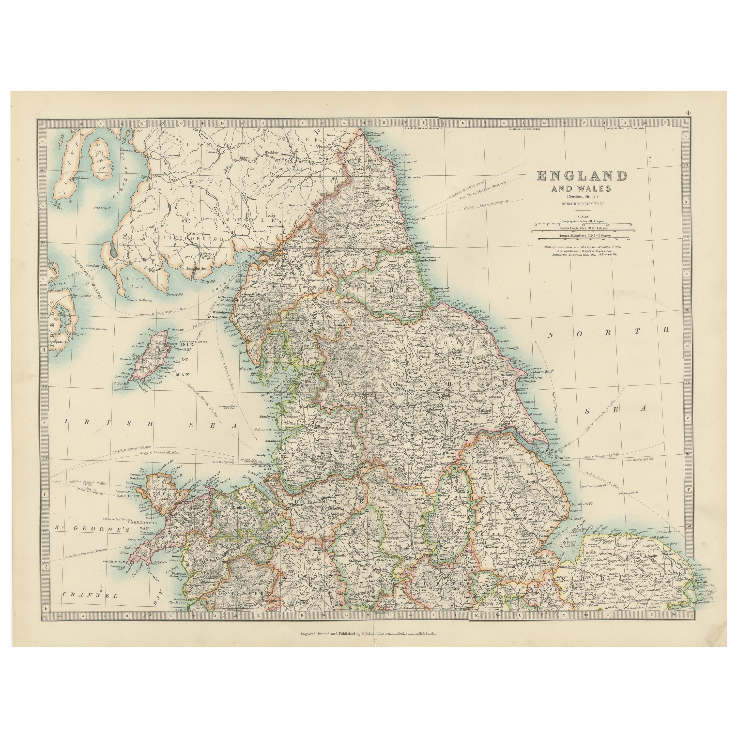
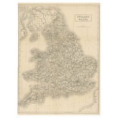
Alle anzeigenAntique Map of England and Wales, 1903, with Detailed Counties and Railways
Title: Antique Map of England and Wales, 1903, with Detailed Counties and Railways
Description:
This beautifully detailed antique map, titled "England and Wales," was engraved and p...
Kategorie
Frühes 20. Jahrhundert, Landkarten
Materialien
Papier
Antique Map of Southern Scotland, 1903, with Coastal and Inland Details
Title: Antique Map of Southern Scotland, 1903, with Coastal and Inland Details
Description:
This exquisite antique map, titled "Scotland (Southern Sheet I)," was engraved and publis...
Kategorie
Frühes 20. Jahrhundert, Landkarten
Materialien
Papier

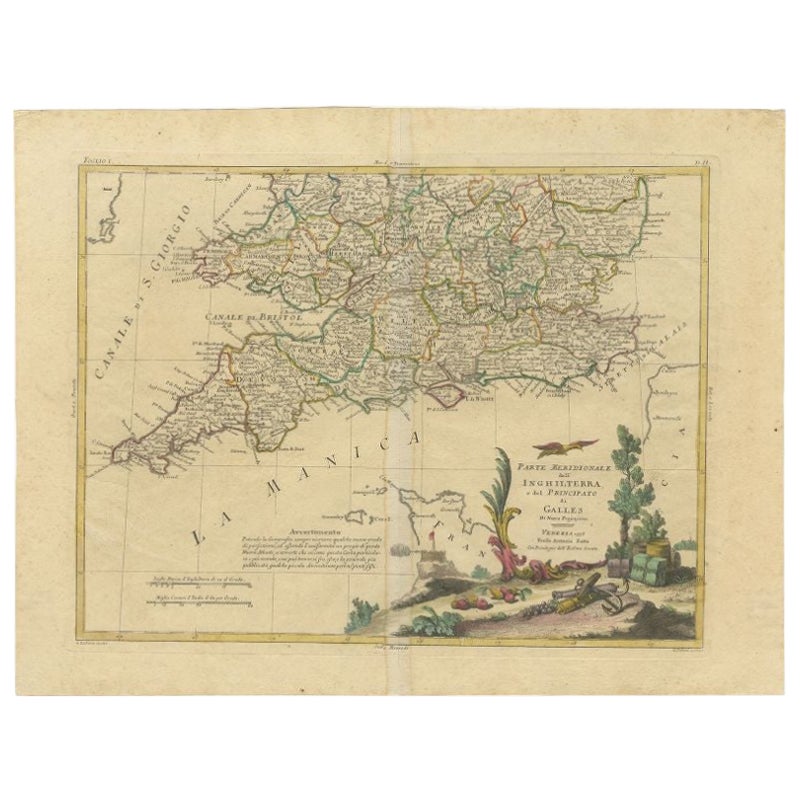
Antike Karte von Südengland und Wales von Zatta, 1784
"Antike Karte mit dem Titel 'Parte Meridionale dell' Inghilterra e del Pricipato di Galles'. Gestochene Karte des südlichen Teils von England und Wales, mit Titelkartusche. Zeigt pol...
Kategorie
Antik, 18. Jahrhundert, Landkarten
Materialien
Papier
198 $ Angebotspreis
20 % Rabatt
Antique Map of Ireland, 1903, with Intricate County Boundaries & Coastal Details
Title: Antique Map of Ireland, 1903, with Intricate County Boundaries and Coastal Detail
Description:
This antique map of Ireland, engraved and published in 1903 by the esteemed W. ...
Kategorie
Frühes 20. Jahrhundert, Landkarten
Materialien
Papier

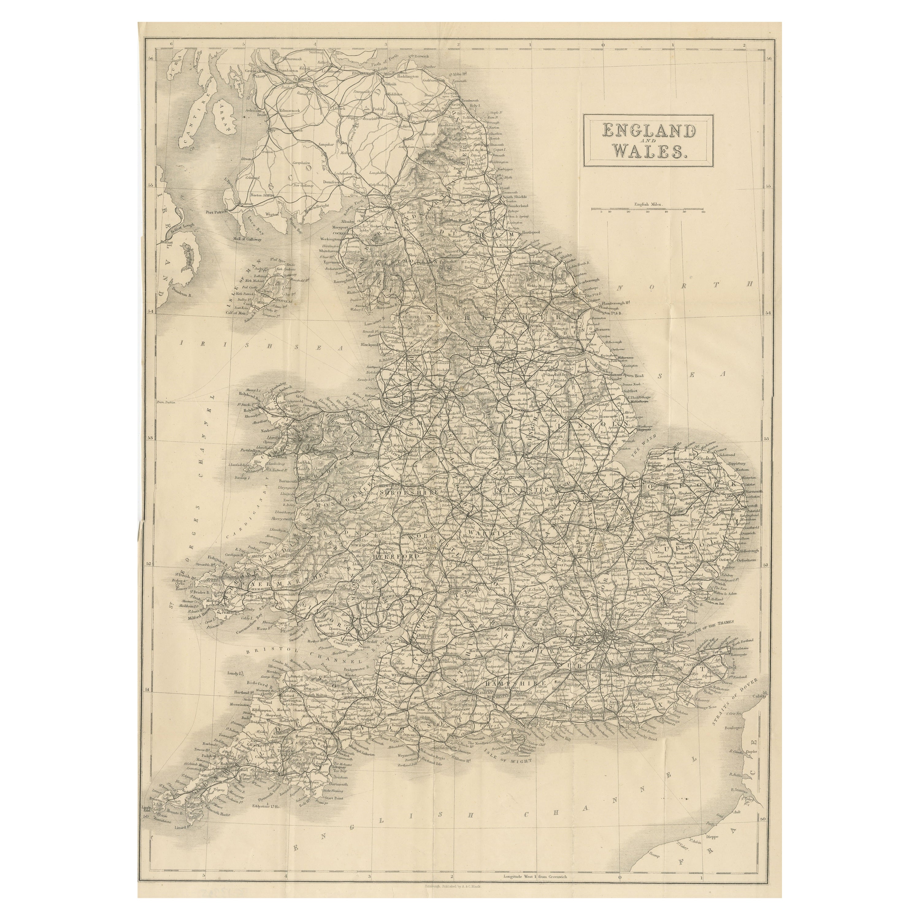
Antike klappbare Karte von England und Wales
Antike Karte mit dem Titel 'England und Wales'. Original-Faltkarte von England und Wales. Verlegt von A. & C. Black, um 1890.
Kategorie
Antik, Spätes 19. Jahrhundert, Landkarten
Materialien
Papier
391 $ Angebotspreis
20 % Rabatt
Große antike Karte von England und Wales
Antike Karte mit dem Titel 'An Accurate Map of England and Wales'. Original alte Karte von England und Wales. Gestochen von John Cary's. Stammt aus dem "New British Atlas" von John S...
Kategorie
Antik, Frühes 19. Jahrhundert, Landkarten
Materialien
Papier

307 $ Angebotspreis
20 % Rabatt
Das könnte Ihnen auch gefallen
Original Antike Karte des amerikanischen Staates Michigan ( Südteil ), 1903
Antike Karte von Michigan (südlicher Teil)
Veröffentlicht von A & C Black. 1903
Original Farbe
Guter Zustand
Ungerahmt.
Kostenloser Versand
Kategorie
Antik, Frühes 20. Jhdt., Englisch, Landkarten
Materialien
Papier

Original Antike Karte des amerikanischen Staates Ohio ( Südteil ), 1903
Antike Karte von Ohio (südlicher Teil)
Veröffentlicht von A & C Black. 1903
Original Farbe
Guter Zustand
Ungerahmt.
Kostenloser Versand
Kategorie
Antik, Frühes 20. Jhdt., Englisch, Landkarten
Materialien
Papier

Original Antike Karte des amerikanischen Staates Kalifornien (Teil Südkaliforniens), 1903
Antike Karte von Kalifornien (südlicher Teil)
Veröffentlicht von A & C Black. 1903
Original Farbe
Guter Zustand
Ungerahmt.
Kostenloser Versand
Kategorie
Antik, Frühes 20. Jhdt., Englisch, Landkarten
Materialien
Papier

49 $
Kostenloser Versand
Original Antike Karte des amerikanischen Staates Illinois ( Südteil ), 1903
Antike Karte von Illinois (südlicher Teil)
Veröffentlicht von A & C Black. 1903
Original Farbe
Guter Zustand
Ungerahmt.
Kostenloser Versand
Kategorie
Antik, Frühes 20. Jhdt., Englisch, Landkarten
Materialien
Papier

Original Antike Karte des amerikanischen Staates Missouri (Teil Südamerikas), 1903
Antike Landkarte von Missouri ( Südlicher Teil )
Veröffentlicht von A & C Black. 1903
Original Farbe
Guter Zustand
Ungerahmt.
Kostenloser Versand
Kategorie
Antik, Frühes 20. Jhdt., Englisch, Landkarten
Materialien
Papier

49 $
Kostenloser Versand
Original Antike Karte des amerikanischen Staates New York ( Südteil) 1903
Antique map of New York ( Southern Part )
Published By A & C Black. 1903
Original colour
Good condition
Unframed.
Free shipping
Kategorie
Antik, Frühes 20. Jhdt., Englisch, Landkarten
Materialien
Papier
