Objekte ähnlich wie Antique Map of Southern Scotland, 1903, with Coastal and Inland Details


Möchten Sie mehr Bilder oder Videos?
Zusätzliche Bilder oder Videos von dem*der Anbieter*in anfordern
1 von 10
Antique Map of Southern Scotland, 1903, with Coastal and Inland Details
Angaben zum Objekt
Title: Antique Map of Southern Scotland, 1903, with Coastal and Inland Details
Description:
This exquisite antique map, titled "Scotland (Southern Sheet I)," was engraved and published in 1903 by the esteemed W. & A.K. Johnston firm in Edinburgh and London. A testament to early 20th-century cartography, it meticulously documents the southern half of Scotland, including its rugged coastlines and bustling cities.
The map’s elegant pastel coloring in soft greens, pinks, and yellows delineates county boundaries and enhances the intricate topographical features, from mountain ranges and lochs to rivers and valleys. Major cities such as Edinburgh and Glasgow are clearly marked, along with smaller towns, railway lines, and maritime routes that showcase the region’s vibrant economy during the industrial era.
One of the highlights is the beautifully depicted Hebrides, nestled off the western coast in the Atlantic Ocean. The map’s clarity and precision extend to the smallest islands, reflecting the meticulous craftsmanship of Johnston’s engravers and their dedication to accuracy.
For collectors, historians, and enthusiasts of Scottish heritage, this map provides a window into the past, illustrating a landscape shaped by centuries of cultural and economic evolution. It also highlights the natural beauty of the Highlands and Lowlands, capturing the distinct character of Scotland’s south with an artistry that resonates even today.
Condition report:
This map is in very good antique condition, showing slight toning and minimal foxing around the edges typical for its age. The color palette remains vibrant and the paper stable and clear.
Framing tips:
A classic dark wood frame in walnut or mahogany will enhance the warm pastel tones and intricate detail of this map. A light cream or ivory matting will further highlight the delicate coloring and provide an elegant presentation, making this piece a refined focal point for any home or office space.
- Maße:Höhe: 36,8 cm (14,49 in)Breite: 48 cm (18,9 in)Tiefe: 0,2 mm (0,01 in)
- Materialien und Methoden:
- Zeitalter:
- Herstellungsjahr:1903
- Zustand:This map is in very good antique condition, showing slight toning and minimal foxing around the edges typical for its age. The color palette remains vibrant and the paper stable and clear. Folding line as issued.
- Anbieterstandort:Langweer, NL
- Referenznummer:Anbieter*in: BG-13577-71stDibs: LU3054345241392
Anbieterinformationen
5,0
Anerkannte Anbieter*innen
Diese renommierten Anbieter*innen sind führend in der Branche und repräsentieren die höchste Klasse in Sachen Qualität und Design.
Gold-Anbieter*in
Premium-Anbieter*innen mit einer Bewertung über 4,3 und 24 Stunden Reaktionszeit
Gründungsjahr 2009
1stDibs-Anbieter*in seit 2017
2.462 Verkäufe auf 1stDibs
Typische Antwortzeit: <1 Stunde
- VersandAngebot wird abgerufen …Versand von: Langweer, Niederlande
- Rückgabebedingungen
Einige Inhalte dieser Seite wurden automatisch übersetzt. Daher kann 1stDibs nicht die Richtigkeit der Übersetzungen garantieren. Englisch ist die Standardsprache dieser Website.
Authentizitätsgarantie
Im unwahrscheinlichen Fall eines Problems mit der Echtheit eines Objekts kontaktieren Sie uns bitte innerhalb von 1 Jahr für eine volle Rückerstattung. DetailsGeld-Zurück-Garantie
Wenn Ihr Objekt nicht der Beschreibung entspricht, beim Transport beschädigt wurde oder nicht ankommt, kontaktieren Sie uns bitte innerhalb von 7 Tagen für eine vollständige Rückerstattung. DetailsStornierung innerhalb von 24 Stunden
Sie können Ihren Kauf jederzeit innerhalb von 24 Stunden stornieren, ohne jegliche Gründe dafür angeben zu müssen.Geprüfte Anbieter*innen
Unsere Anbieter*innen unterliegen strengen Dienstleistungs- und Qualitätsstandards, wodurch wir die Seriosität unserer Angebote gewährleisten können.Preisgarantie
Wenn Sie feststellen, dass ein*e Anbieter*in dasselbe Objekt anderswo zu einem niedrigeren Preis anbietet, werden wir den Preis entsprechend anpassen.Zuverlässige weltweite Lieferung
Unsere erstklassigen Versandunternehmen bieten spezielle Versandoptionen weltweit, einschließlich individueller Lieferung.Mehr von diesem*dieser Anbieter*in
Alle anzeigenAntique Map of Southern England & Wales, 1903, with Coastal Details and Railways
Title: Antique Map of Southern England and Wales, 1903, with Coastal Details and Railways
Description:
This detailed antique map, titled "England and Wales (Southern Sheet I)," was ...
Kategorie
Frühes 20. Jahrhundert, Landkarten
Materialien
Papier
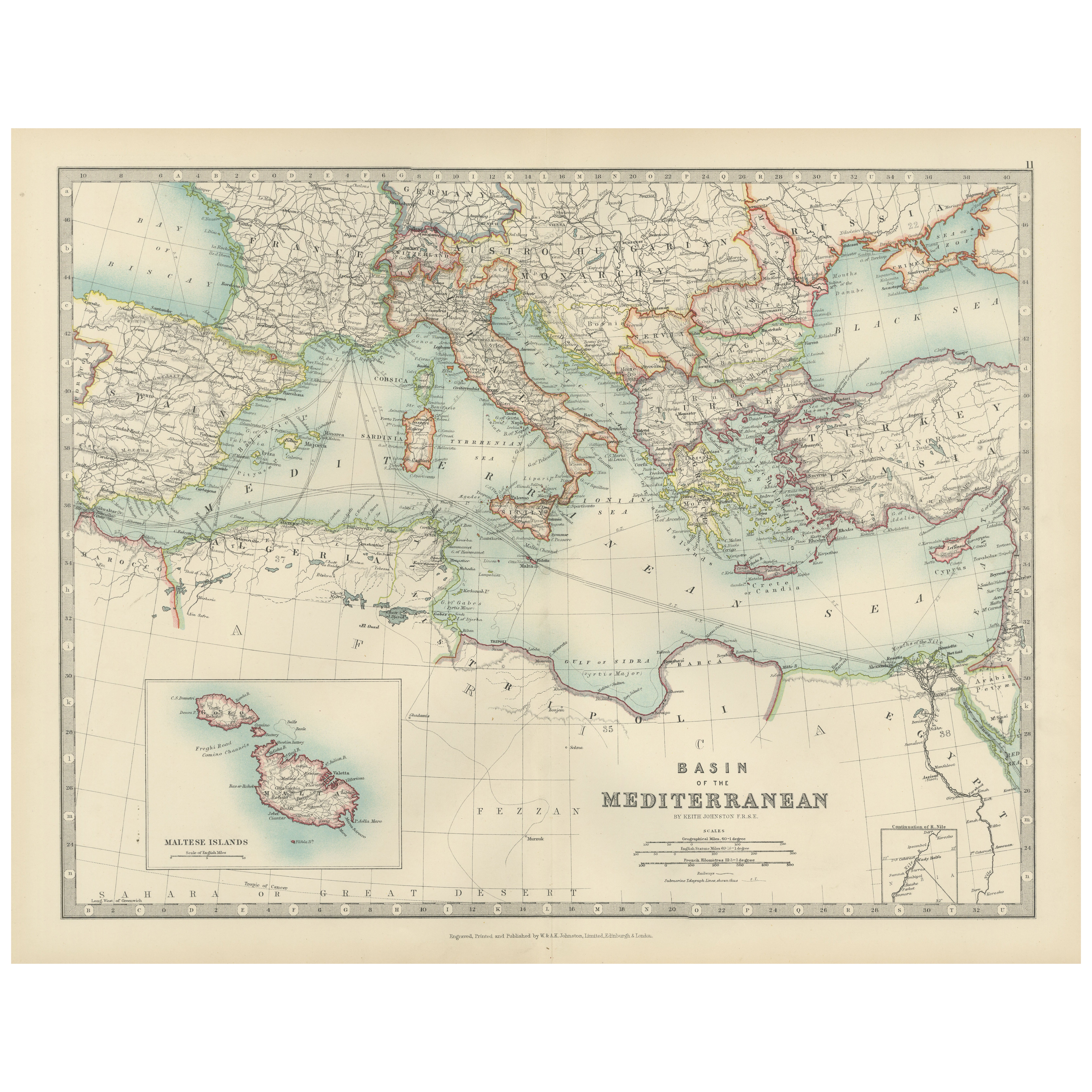
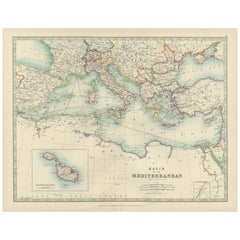
Antique Map of the Mediterranean Basin, 1903, with Detailed Coastal and Inland
Title: Antique Map of the Mediterranean Basin, 1903, with Detailed Coastal and Inland Geography
Description: This antique map, titled "Basin of the Mediterranean," was engraved and ...
Kategorie
Frühes 20. Jahrhundert, Landkarten
Materialien
Papier
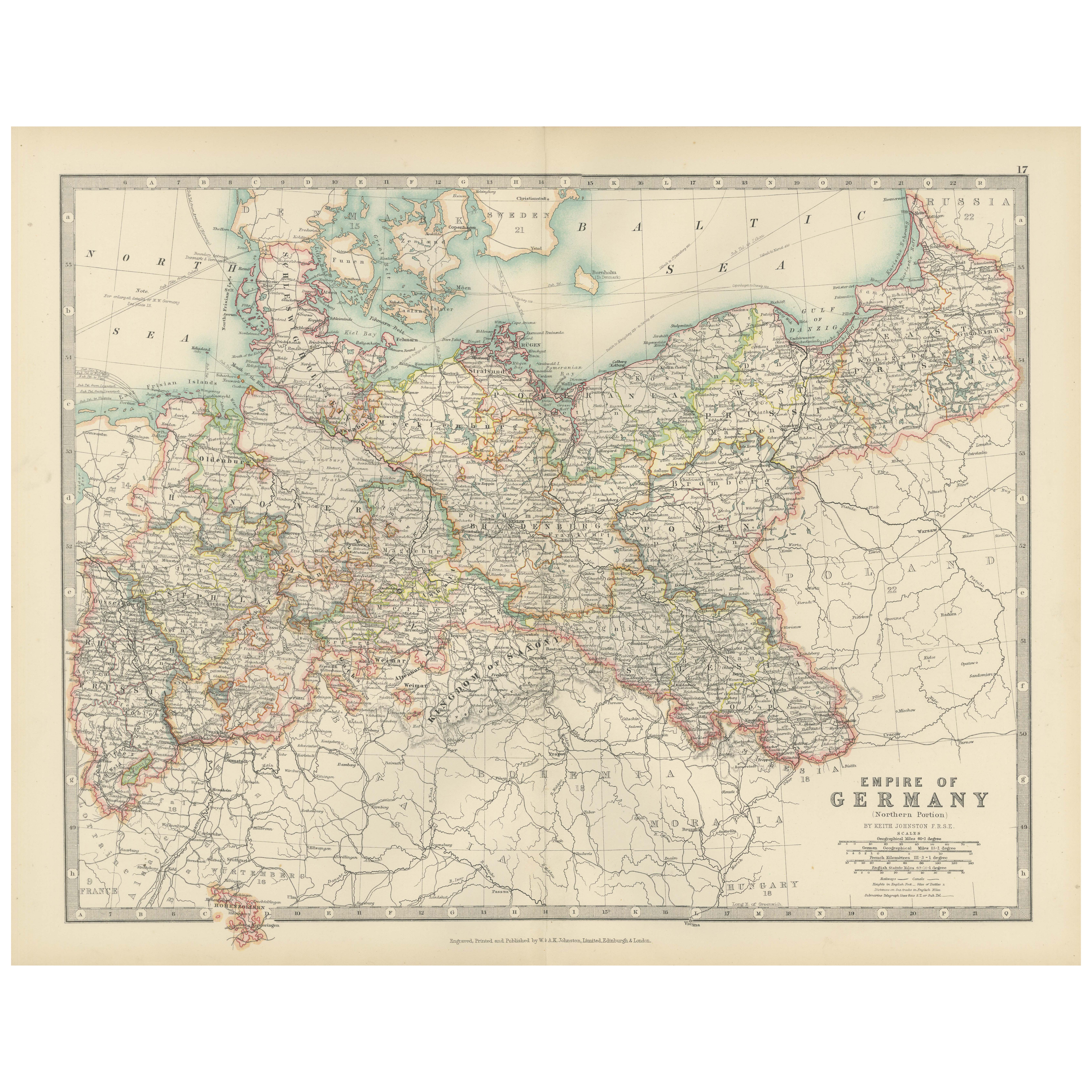
Antique Map of the German Empire, 1903, Northern Portion with Coastal and Inland
Title: Antique Map of the German Empire, 1903, Northern Portion with Coastal and Inland Detail
Description:
This antique map, titled "Empire of Germany (Northern Portion)," was engr...
Kategorie
Frühes 20. Jahrhundert, Landkarten
Materialien
Papier

Antique Map of Northern Scotland, 1903, with Intricate Coastal Features
Title: Antique Map of Northern Scotland and Islands, 1903, with Intricate Coastal Features
Description:
This striking antique map, titled "Scotland (Northern Sheet I)," was engraved...
Kategorie
Frühes 20. Jahrhundert, Landkarten
Materialien
Papier

Antique Map of Ireland, 1903, with Intricate County Boundaries & Coastal Details
Title: Antique Map of Ireland, 1903, with Intricate County Boundaries and Coastal Detail
Description:
This antique map of Ireland, engraved and published in 1903 by the esteemed W. ...
Kategorie
Frühes 20. Jahrhundert, Landkarten
Materialien
Papier

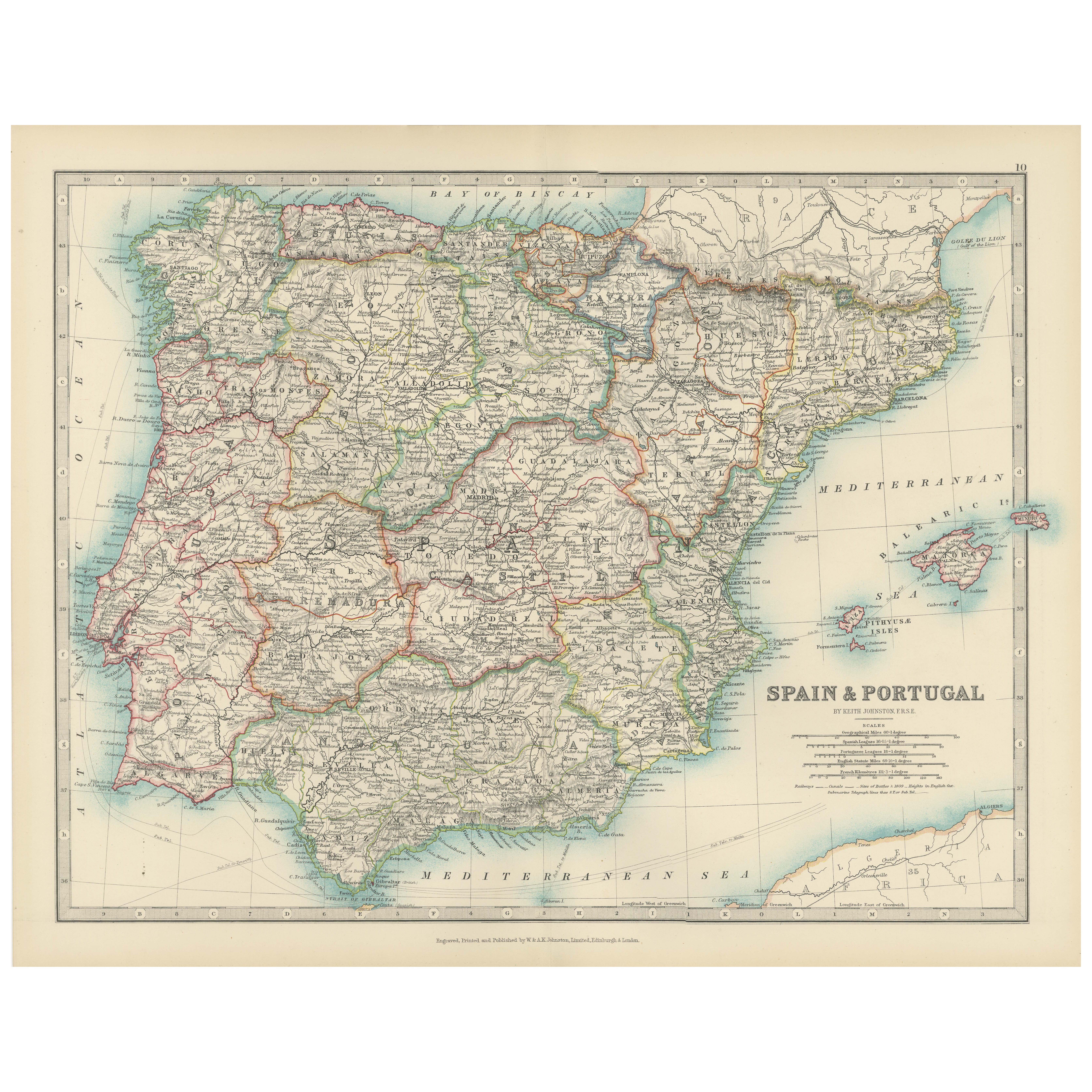
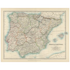
Antique Map of Spain and Portugal, 1903, Regional Boundaries and Coastal Detail
Antique Map of Spain and Portugal, 1903, Featuring Regional Boundaries and Coastal Detail
Description: This antique map, titled "Spain & Portugal," was engraved and published in 190...
Kategorie
Frühes 20. Jahrhundert, Landkarten
Materialien
Papier
Das könnte Ihnen auch gefallen
Original Antike Karte des amerikanischen Staates Michigan ( Südteil ), 1903
Antike Karte von Michigan (südlicher Teil)
Veröffentlicht von A & C Black. 1903
Original Farbe
Guter Zustand
Ungerahmt.
Kostenloser Versand
Kategorie
Antik, Frühes 20. Jhdt., Englisch, Landkarten
Materialien
Papier

Original Antike Karte des amerikanischen Staates Ohio ( Südteil ), 1903
Antike Karte von Ohio (südlicher Teil)
Veröffentlicht von A & C Black. 1903
Original Farbe
Guter Zustand
Ungerahmt.
Kostenloser Versand
Kategorie
Antik, Frühes 20. Jhdt., Englisch, Landkarten
Materialien
Papier

Original Antike Karte des amerikanischen Staates Kalifornien (Teil Südkaliforniens), 1903
Antike Karte von Kalifornien (südlicher Teil)
Veröffentlicht von A & C Black. 1903
Original Farbe
Guter Zustand
Ungerahmt.
Kostenloser Versand
Kategorie
Antik, Frühes 20. Jhdt., Englisch, Landkarten
Materialien
Papier

49 $
Kostenloser Versand
Original Antike Karte des amerikanischen Staates Illinois ( Südteil ), 1903
Antike Karte von Illinois (südlicher Teil)
Veröffentlicht von A & C Black. 1903
Original Farbe
Guter Zustand
Ungerahmt.
Kostenloser Versand
Kategorie
Antik, Frühes 20. Jhdt., Englisch, Landkarten
Materialien
Papier

Original Antike Karte des amerikanischen Staates Missouri (Teil Südamerikas), 1903
Antike Landkarte von Missouri ( Südlicher Teil )
Veröffentlicht von A & C Black. 1903
Original Farbe
Guter Zustand
Ungerahmt.
Kostenloser Versand
Kategorie
Antik, Frühes 20. Jhdt., Englisch, Landkarten
Materialien
Papier

49 $
Kostenloser Versand
Original Antike Karte des amerikanischen Staates New York ( Südteil) 1903
Antique map of New York ( Southern Part )
Published By A & C Black. 1903
Original colour
Good condition
Unframed.
Free shipping
Kategorie
Antik, Frühes 20. Jhdt., Englisch, Landkarten
Materialien
Papier
