Objekte ähnlich wie Antique Map of the Austro-Hungarian Monarchy, 1903, with Colorful Borderlines


Möchten Sie mehr Bilder oder Videos?
Zusätzliche Bilder oder Videos von dem*der Anbieter*in anfordern
1 von 10
Antique Map of the Austro-Hungarian Monarchy, 1903, with Colorful Borderlines
Angaben zum Objekt
Title: Antique Map of the Austro-Hungarian Monarchy, 1903, with Colorful Provincial Borders
Description:
This antique map, titled "Austro-Hungarian Monarchy," was engraved and published in 1903 by the renowned W. & A.K. Johnston in Edinburgh and London. It offers a detailed and colorful depiction of the Austro-Hungarian Empire at the height of its power, just before the sweeping changes of the early 20th century reshaped the region.
The map elegantly delineates the complex mosaic of provinces within the empire, including Austria, Hungary, Bohemia, Galicia, Dalmatia, and many others, each highlighted in soft pastel shades of pink, green, yellow, and blue. Major cities like Vienna, Budapest, Prague, and Trieste are clearly marked, along with rivers, mountain ranges, and railways that knit the diverse regions together.
One of the map’s standout features is the inset map of the Adriatic coastline, titled "Continuation of Dalmatia," showcasing the maritime and strategic importance of the empire’s coastal territories. The precision and artistry of the engraving bring to life the rich cultural and geographical diversity that made the Austro-Hungarian Monarchy one of Europe’s great powers.
For collectors and history enthusiasts, this map is a window into the final decades of a multi-ethnic empire that played a central role in European affairs. It’s a reminder of a world on the verge of dramatic political upheaval, beautifully captured in the refined craftsmanship of Johnston’s cartography.
Condition report:
This map is in very good antique condition, with minimal foxing and slight edge toning typical for its age. The colors remain vibrant and the paper is well-preserved.
Framing tips:
A dark wooden frame in walnut or cherry will enhance the soft pastel tones and add a sense of warmth and sophistication. Pair it with a cream or off-white matting to highlight the detailed engraving and create a refined and timeless focal point for any home, library, or study.
- Maße:Höhe: 36,8 cm (14,49 in)Breite: 47 cm (18,51 in)Tiefe: 0,2 mm (0,01 in)
- Materialien und Methoden:
- Zeitalter:
- Herstellungsjahr:1903
- Zustand:This map is in very good antique condition, showing only slight toning and minor foxing typical for its age. The colors remain vibrant and the paper stable and clear. Two folding lines as issued.
- Anbieterstandort:Langweer, NL
- Referenznummer:Anbieter*in: BG-13577-181stDibs: LU3054345242852
Anbieterinformationen
5,0
Anerkannte Anbieter*innen
Diese renommierten Anbieter*innen sind führend in der Branche und repräsentieren die höchste Klasse in Sachen Qualität und Design.
Gold-Anbieter*in
Premium-Anbieter*innen mit einer Bewertung über 4,3 und 24 Stunden Reaktionszeit
Gründungsjahr 2009
1stDibs-Anbieter*in seit 2017
2.452 Verkäufe auf 1stDibs
Typische Antwortzeit: <1 Stunde
- VersandAngebot wird abgerufen …Versand von: Langweer, Niederlande
- Rückgabebedingungen
Einige Inhalte dieser Seite wurden automatisch übersetzt. Daher kann 1stDibs nicht die Richtigkeit der Übersetzungen garantieren. Englisch ist die Standardsprache dieser Website.
Authentizitätsgarantie
Im unwahrscheinlichen Fall eines Problems mit der Echtheit eines Objekts kontaktieren Sie uns bitte innerhalb von 1 Jahr für eine volle Rückerstattung. DetailsGeld-Zurück-Garantie
Wenn Ihr Objekt nicht der Beschreibung entspricht, beim Transport beschädigt wurde oder nicht ankommt, kontaktieren Sie uns bitte innerhalb von 7 Tagen für eine vollständige Rückerstattung. DetailsStornierung innerhalb von 24 Stunden
Sie können Ihren Kauf jederzeit innerhalb von 24 Stunden stornieren, ohne jegliche Gründe dafür angeben zu müssen.Geprüfte Anbieter*innen
Unsere Anbieter*innen unterliegen strengen Dienstleistungs- und Qualitätsstandards, wodurch wir die Seriosität unserer Angebote gewährleisten können.Preisgarantie
Wenn Sie feststellen, dass ein*e Anbieter*in dasselbe Objekt anderswo zu einem niedrigeren Preis anbietet, werden wir den Preis entsprechend anpassen.Zuverlässige weltweite Lieferung
Unsere erstklassigen Versandunternehmen bieten spezielle Versandoptionen weltweit, einschließlich individueller Lieferung.Mehr von diesem*dieser Anbieter*in
Alle anzeigenAntique Map of European Russia, 1903, with Colorful Provincial Boundaries
Title: Antique Map of European Russia, 1903, with Colorful Provincial Boundaries
Description:
This antique map, titled "European Russia," was engraved and published in 1903 by W. & ...
Kategorie
Frühes 20. Jahrhundert, Landkarten
Materialien
Papier
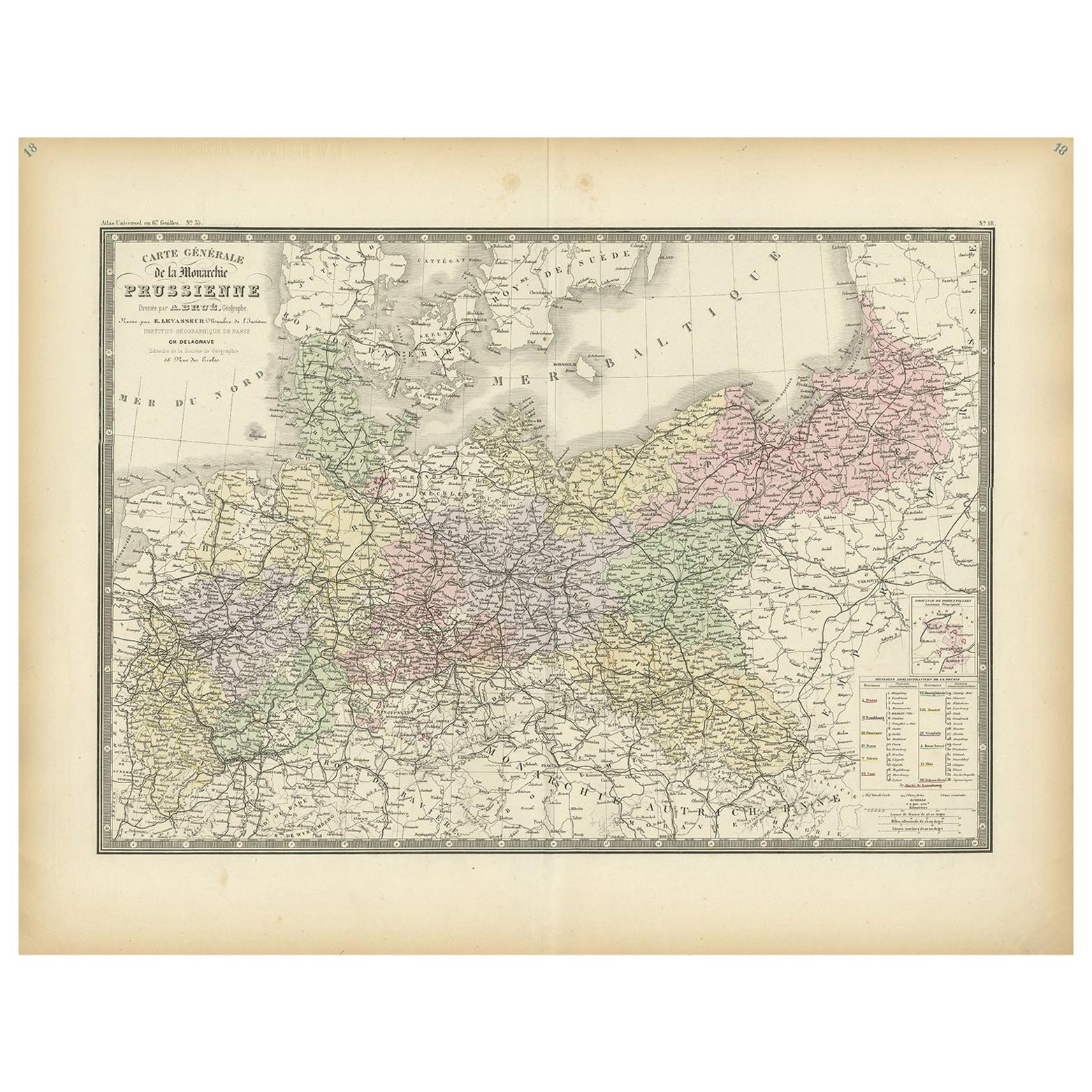
Antike Karte der preußischen Monarchy von Levasseur, '1875'
Antike Karte mit dem Titel 'Carte générale de la Monarchie Prussienne (...)'. Große Karte der Preußischen Monarchie. Diese Karte stammt aus dem "Atlas de Géographie Moderne Physique ...
Kategorie
Antik, Spätes 19. Jahrhundert, Landkarten
Materialien
Papier
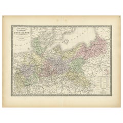
371 $ Angebotspreis
20 % Rabatt
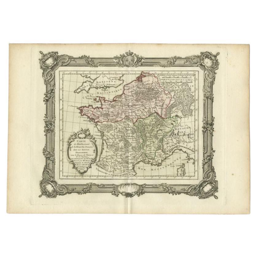
Antike Karte der Gründung der französischen Monarchy von Zannoni, 1765
Antike Landkarte Frankreichs mit dem Titel 'Carte de l'Etablissement de la Monarchie Francoise (...)'. Schöne alte Karte von Frankreich. Diese Karte stammt aus dem "Atlas Historique ...
Kategorie
Antik, 18. Jahrhundert, Landkarten
Materialien
Papier
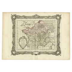
151 $ Angebotspreis
20 % Rabatt
Antique Map of the German Empire, 1903, with Intricate Provincial Boundaries
Title: Antique Map of the German Empire, 1903, with Intricate Provincial Boundaries
Description:
This antique map, titled "Empire of Germany (Southern Portion)," was engraved and pu...
Kategorie
Frühes 20. Jahrhundert, Landkarten
Materialien
Papier

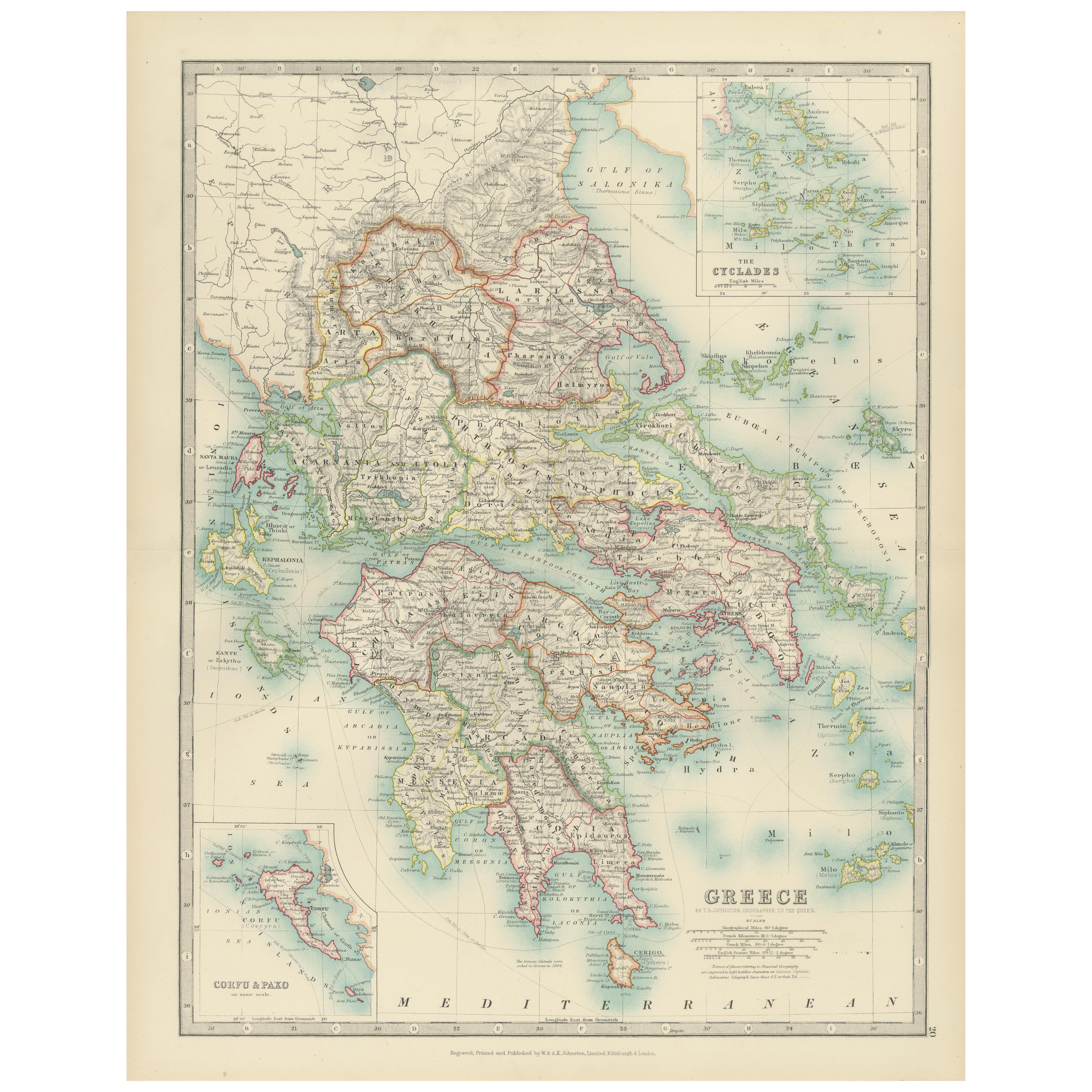
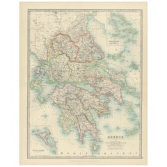
Antique Map of Greece and the Cyclades, 1903, with Many Details and Inset Maps
Title: Antique Map of Greece and the Cyclades, 1903, with Intricate Detail and Inset Maps
Description: This antique map, titled "Greece with Its Islands, Including the Cyclades," wa...
Kategorie
Frühes 20. Jahrhundert, Landkarten
Materialien
Papier
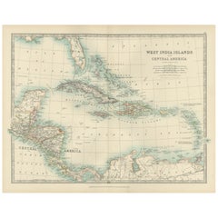
Map of the West India Islands and Central America – Colorful 1903 Engraving
Map of the West India Islands and Central America – Colorful 1903 Engraving
This vibrant engraved map, titled "West India Islands and Central America," was created by Keith Johnston...
Kategorie
Frühes 20. Jahrhundert, Landkarten
Materialien
Papier
Das könnte Ihnen auch gefallen
Original Antike Karte des amerikanischen Staates Minnesota, 1903
Antike Karte von Minnesota
Veröffentlicht von A & C Black. 1903
Original Farbe
Guter Zustand
Ungerahmt.
Kostenloser Versand
Kategorie
Antik, Frühes 20. Jhdt., Englisch, Landkarten
Materialien
Papier

Original Antike Karte des amerikanischen Staates Alabama, 1903
Antique map of Alabama
Published By A & C Black. 1903
Original colour
Good condition
Unframed.
Free shipping
Kategorie
Antik, Frühes 20. Jhdt., Englisch, Landkarten
Materialien
Papier

Original Antike Karte des amerikanischen Staates Alaska, 1903
Antike Karte von Alaska
Veröffentlicht von A & C Black. 1903
Original Farbe
Guter Zustand
Ungerahmt.
Kostenloser Versand
Kategorie
Antik, Frühes 20. Jhdt., Englisch, Landkarten
Materialien
Papier

Original Antike Karte des amerikanischen Staates Nebraska, 1903
Antike Karte von Nebraska
Veröffentlicht von A & C Black. 1903
Original Farbe
Guter Zustand
Ungerahmt.
Kostenloser Versand
Kategorie
Antik, Frühes 20. Jhdt., Englisch, Landkarten
Materialien
Papier

Antike Karte des amerikanischen Staates Washington, 1903
Antike Karte von Washington
Veröffentlicht von A & C Black. 1903
Original Farbe
Guter Zustand
Ungerahmt.
Kostenloser Versand
Kategorie
Antik, Frühes 20. Jhdt., Englisch, Landkarten
Materialien
Papier

Original Antike Karte des amerikanischen Staates Tennessee, 1903
Antique map of Tennessee
Published By A & C Black. 1903
Original colour
Good condition
Unframed.
Free shipping
Kategorie
Antik, Frühes 20. Jhdt., Englisch, Landkarten
Materialien
Papier
