Objekte ähnlich wie Antique Map of the German Empire, 1903, Northern Portion with Coastal and Inland


Möchten Sie mehr Bilder oder Videos?
Zusätzliche Bilder oder Videos von dem*der Anbieter*in anfordern
1 von 10
Antique Map of the German Empire, 1903, Northern Portion with Coastal and Inland
Angaben zum Objekt
Title: Antique Map of the German Empire, 1903, Northern Portion with Coastal and Inland Detail
Description:
This antique map, titled "Empire of Germany (Northern Portion)," was engraved and published in 1903 by the respected W. & A.K. Johnston in Edinburgh and London. It offers a richly detailed and colored portrayal of the northern part of the German Empire at the dawn of the 20th century, capturing the historical geography and political divisions of this powerful and complex nation.
Hand-colored in soft pastel shades of pink, green, yellow, and blue, this map elegantly delineates provincial and administrative boundaries. From the bustling port cities along the North Sea and Baltic Sea to the inland heartlands of Prussia and Saxony, the map reveals the extensive railways, rivers, and road networks that defined the region’s industrial might and cultural vibrancy.
The map also highlights Germany’s coastal regions, including the Frisian Islands, Pomerania, and East Prussia, emphasizing the maritime and economic importance of these areas. Johnston’s precise linework and careful typography make this map not just a historical document but a work of art that reflects the meticulous skill and dedication of the era’s finest cartographers.
For collectors, historians, and those with an interest in German history and geography, this map is a captivating window into a time of growth and ambition within the German Empire. It captures the dynamic landscape of a region that would soon see tremendous changes in the early 20th century.
Condition report:
This map is in very good antique condition, with slight foxing and toning around the edges consistent with its age. The colors remain vibrant and the paper is well-preserved.
Framing tips:
A classic dark wooden frame, such as walnut or mahogany, will complement the map’s warm pastel tones. Use a cream or light tan matting to highlight the delicate coloring and detailed engraving, creating an elegant and timeless display for any home, study, or office.
- Maße:Höhe: 36,8 cm (14,49 in)Breite: 47 cm (18,51 in)Tiefe: 0,2 mm (0,01 in)
- Materialien und Methoden:
- Zeitalter:
- Herstellungsjahr:1903
- Zustand:This map is in very good antique condition, showing only slight toning and minor foxing typical for its age. The colors remain vibrant and the paper stable and clear. Two folding lines as issued.
- Anbieterstandort:Langweer, NL
- Referenznummer:Anbieter*in: BG-13577-171stDibs: LU3054345242572
Anbieterinformationen
5,0
Anerkannte Anbieter*innen
Diese renommierten Anbieter*innen sind führend in der Branche und repräsentieren die höchste Klasse in Sachen Qualität und Design.
Gold-Anbieter*in
Premium-Anbieter*innen mit einer Bewertung über 4,3 und 24 Stunden Reaktionszeit
Gründungsjahr 2009
1stDibs-Anbieter*in seit 2017
2.462 Verkäufe auf 1stDibs
Typische Antwortzeit: <1 Stunde
- VersandAngebot wird abgerufen …Versand von: Langweer, Niederlande
- Rückgabebedingungen
Einige Inhalte dieser Seite wurden automatisch übersetzt. Daher kann 1stDibs nicht die Richtigkeit der Übersetzungen garantieren. Englisch ist die Standardsprache dieser Website.
Authentizitätsgarantie
Im unwahrscheinlichen Fall eines Problems mit der Echtheit eines Objekts kontaktieren Sie uns bitte innerhalb von 1 Jahr für eine volle Rückerstattung. DetailsGeld-Zurück-Garantie
Wenn Ihr Objekt nicht der Beschreibung entspricht, beim Transport beschädigt wurde oder nicht ankommt, kontaktieren Sie uns bitte innerhalb von 7 Tagen für eine vollständige Rückerstattung. DetailsStornierung innerhalb von 24 Stunden
Sie können Ihren Kauf jederzeit innerhalb von 24 Stunden stornieren, ohne jegliche Gründe dafür angeben zu müssen.Geprüfte Anbieter*innen
Unsere Anbieter*innen unterliegen strengen Dienstleistungs- und Qualitätsstandards, wodurch wir die Seriosität unserer Angebote gewährleisten können.Preisgarantie
Wenn Sie feststellen, dass ein*e Anbieter*in dasselbe Objekt anderswo zu einem niedrigeren Preis anbietet, werden wir den Preis entsprechend anpassen.Zuverlässige weltweite Lieferung
Unsere erstklassigen Versandunternehmen bieten spezielle Versandoptionen weltweit, einschließlich individueller Lieferung.Mehr von diesem*dieser Anbieter*in
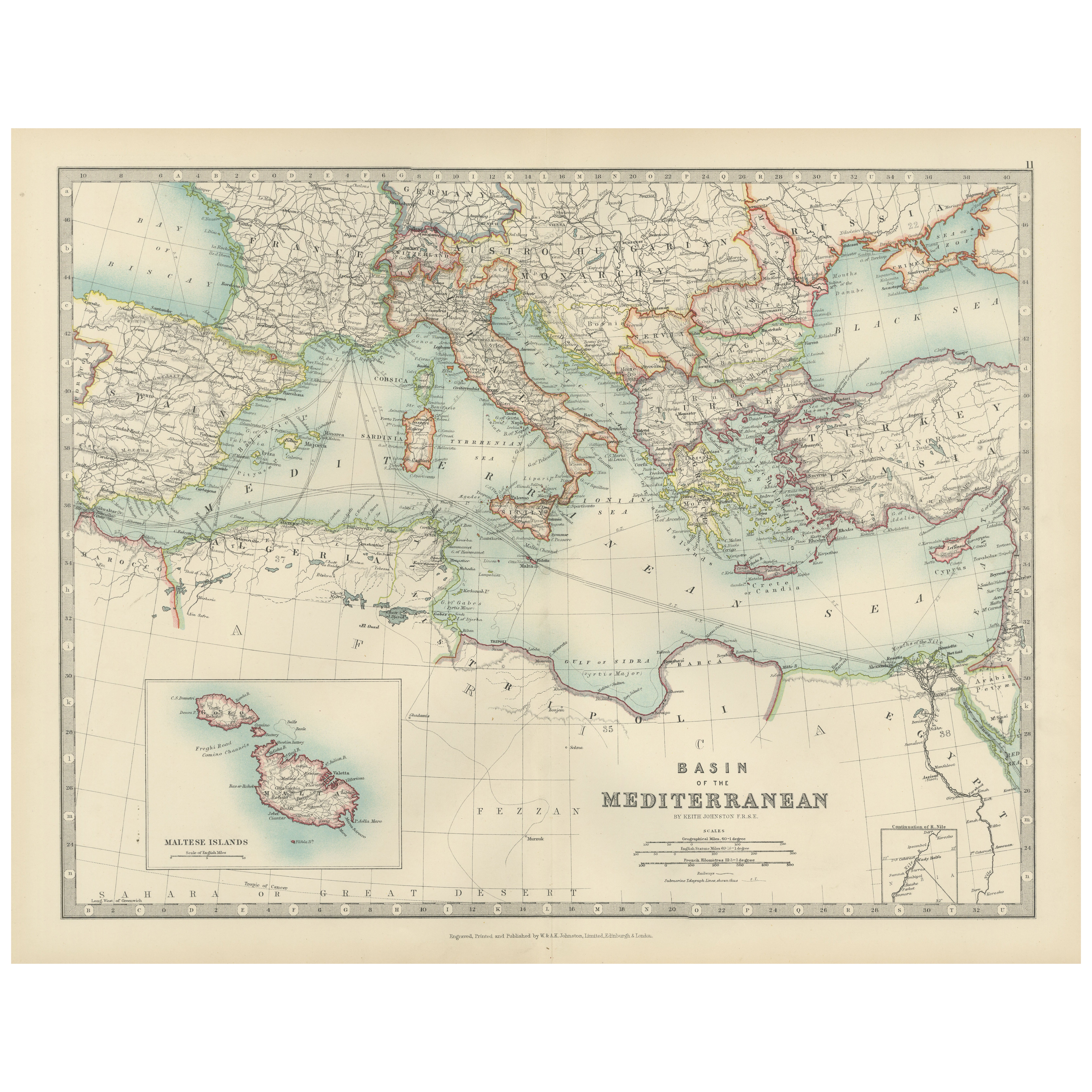
Alle anzeigenAntique Map of the Mediterranean Basin, 1903, with Detailed Coastal and Inland
Title: Antique Map of the Mediterranean Basin, 1903, with Detailed Coastal and Inland Geography
Description: This antique map, titled "Basin of the Mediterranean," was engraved and ...
Kategorie
Frühes 20. Jahrhundert, Landkarten
Materialien
Papier
Antique Map of Southern Scotland, 1903, with Coastal and Inland Details
Title: Antique Map of Southern Scotland, 1903, with Coastal and Inland Details
Description:
This exquisite antique map, titled "Scotland (Southern Sheet I)," was engraved and publis...
Kategorie
Frühes 20. Jahrhundert, Landkarten
Materialien
Papier

Antique Map of Northern Scotland, 1903, with Intricate Coastal Features
Title: Antique Map of Northern Scotland and Islands, 1903, with Intricate Coastal Features
Description:
This striking antique map, titled "Scotland (Northern Sheet I)," was engraved...
Kategorie
Frühes 20. Jahrhundert, Landkarten
Materialien
Papier

Antique Map of the German Empire, 1903, with Intricate Provincial Boundaries
Title: Antique Map of the German Empire, 1903, with Intricate Provincial Boundaries
Description:
This antique map, titled "Empire of Germany (Southern Portion)," was engraved and pu...
Kategorie
Frühes 20. Jahrhundert, Landkarten
Materialien
Papier

Antike Karte der nordlichen Portion der Philippinen von J.N. Bellin, 1764
Detaillierte Karte des nördlichen Teils der Philippinen, der sich von Batanes und Babuyanes bis Mindonoro und Masbate erstreckt und auf Luzon zentriert ist. Eine der detailliertesten...
Kategorie
Antik, Mitte des 18. Jahrhunderts, Landkarten
Materialien
Papier

255 $ Angebotspreis
16 % Rabatt
Antique Map of Denmark and German Empire Regions, 1903, Intricate and Colorful
Title: Antique Map of Denmark and German Empire Regions, 1903, Intricate and Colorful
Description:
This antique map, titled "Denmark with North West Portions of the German Empire," ...
Kategorie
Frühes 20. Jahrhundert, Landkarten
Materialien
Papier
Das könnte Ihnen auch gefallen
Original Antike Karte des amerikanischen Staates Illinois ( nördlicher Teil), 1903
Antike Landkarte von Illinois (nördlicher Teil)
Veröffentlicht von A & C Black. 1903
Original Farbe
Guter Zustand
Ungerahmt.
Kostenloser Versand
Kategorie
Antik, Frühes 20. Jhdt., Englisch, Landkarten
Materialien
Papier

49 $
Kostenloser Versand
Original Antike Karte des amerikanischen Staates Michigan (Nördlicher Teil), 1903
Antike Karte von Michigan (nördlicher Teil)
Veröffentlicht von A & C Black. 1903
Original Farbe
Guter Zustand
Ungerahmt.
Kostenloser Versand
Kategorie
Antik, Frühes 20. Jhdt., Englisch, Landkarten
Materialien
Papier

49 $
Kostenloser Versand
Original Antike Karte des amerikanischen Staates Ohio ( nördlicher Teil), 1903
Antike Karte von Ohio (nördlicher Teil)
Veröffentlicht von A & C Black. 1903
Original Farbe
Guter Zustand
Ungerahmt.
Kostenloser Versand
Kategorie
Antik, Frühes 20. Jhdt., Englisch, Landkarten
Materialien
Papier

49 $
Kostenloser Versand
Original Antike Karte des amerikanischen Staates Kalifornien (Nördlicher Teil), 1903
Antike Karte von Kalifornien (nördlicher Teil)
Veröffentlicht von A & C Black. 1903
Original Farbe
Guter Zustand
Ungerahmt.
Kostenloser Versand
Kategorie
Antik, Frühes 20. Jhdt., Englisch, Landkarten
Materialien
Papier

49 $
Kostenloser Versand
Original Antike Karte des amerikanischen Staates Missouri ( nördlicher Teil), 1903
Antike Landkarte von Missouri (Nördlicher Teil)
Veröffentlicht von A & C Black. 1903
Original Farbe
Guter Zustand
Ungerahmt.
Kostenloser Versand
Kategorie
Antik, Frühes 20. Jhdt., Englisch, Landkarten
Materialien
Papier

49 $
Kostenloser Versand
Original Antike Karte des amerikanischen Staates New York ( nördlicher Teil) 1903
Antique map of New York ( Northern Part )
Published By A & C Black. 1903
Original colour
Good condition
Unframed.
Free shipping
Kategorie
Antik, Frühes 20. Jhdt., Englisch, Landkarten
Materialien
Papier

49 $
Kostenloser Versand