Objekte ähnlich wie Antique Map of the German Empire, 1903, with Intricate Provincial Boundaries


Möchten Sie mehr Bilder oder Videos?
Zusätzliche Bilder oder Videos von dem*der Anbieter*in anfordern
1 von 10
Antique Map of the German Empire, 1903, with Intricate Provincial Boundaries
Angaben zum Objekt
Title: Antique Map of the German Empire, 1903, with Intricate Provincial Boundaries
Description:
This antique map, titled "Empire of Germany (Southern Portion)," was engraved and published in 1903 by the esteemed cartographic firm W. & A.K. Johnston in Edinburgh and London. It offers a richly detailed and color-coded portrayal of the German Empire in the early 20th century, capturing the historical geography and political structure of the time.
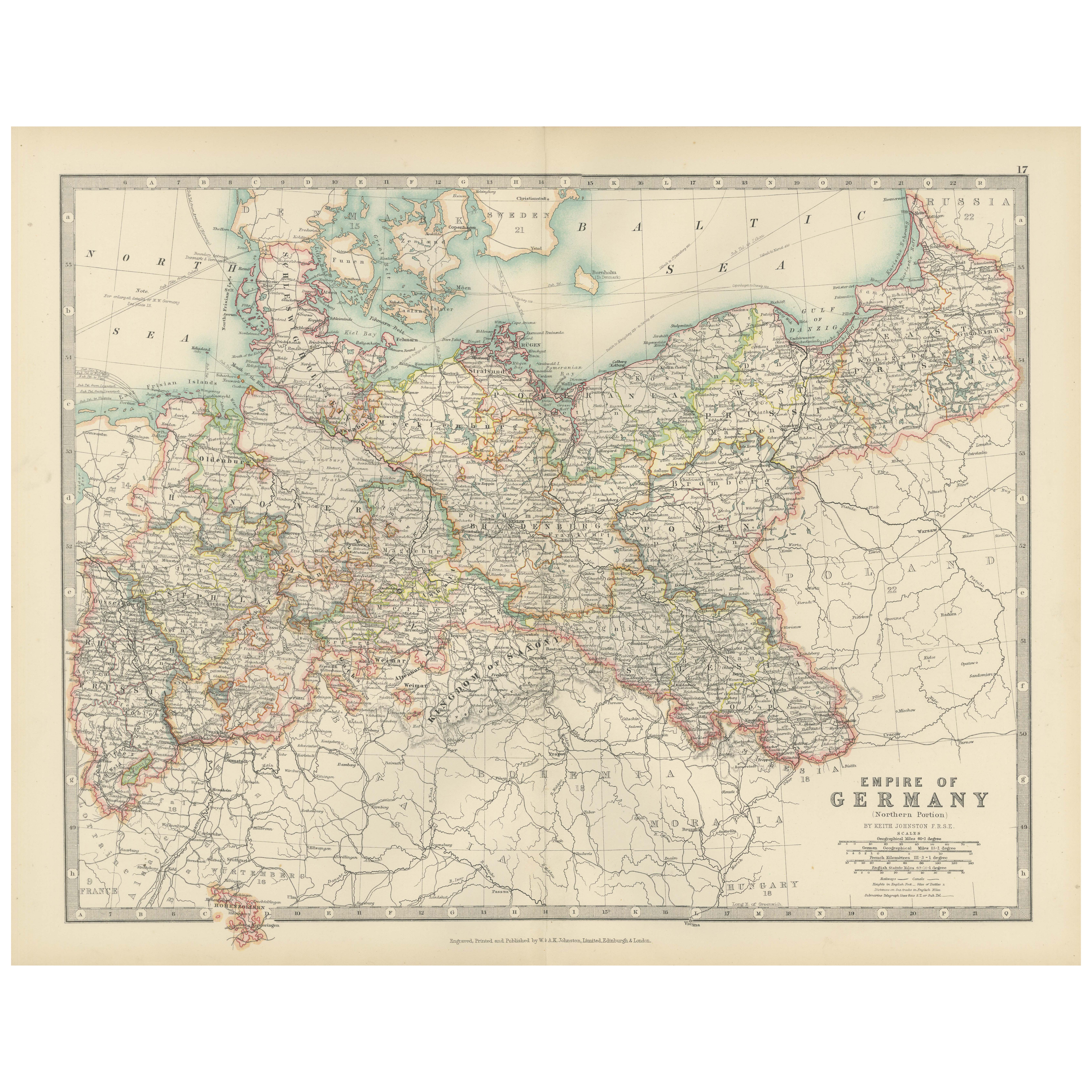
Delicately hand-colored in pastel shades, this map elegantly delineates the provincial and kingdom boundaries, including well-known regions such as Bavaria, Württemberg, Saxony, and Prussia. Major cities, towns, rivers, and an extensive railway network are meticulously engraved, reflecting Germany’s burgeoning industrial and political power during this period.
The map’s fine linework and clear typography highlight the precision and artistry typical of Johnston’s cartography. It provides a comprehensive view of southern Germany’s intricate landscape, from the Rhine and Danube rivers to the picturesque mountain ranges and dense forested areas that define the region.
For collectors and history enthusiasts, this map is a valuable piece that captures the cultural and political complexity of a region on the cusp of profound change. It offers a window into the world of Imperial Germany, just before the seismic shifts of the 20th century would alter the map of Europe forever.
Condition report:
The map is in very good antique condition, with slight toning and minimal foxing along the edges consistent with its age. The color remains vibrant and the paper stable.
Framing tips:
A dark wood frame in walnut or oak will complement the warm pastel hues and historical character of the map. Use a cream or light tan matting to accentuate the intricate engraving, creating a sophisticated focal point for any home, library, or study.
- Maße:Höhe: 36,8 cm (14,49 in)Breite: 52,3 cm (20,6 in)Tiefe: 0,2 mm (0,01 in)
- Materialien und Methoden:
- Zeitalter:
- Herstellungsjahr:1903
- Zustand:This map is in very good antique condition, showing only slight toning and minor foxing typical for its age. The colors remain vibrant and the paper stable and clear. Two folding lines as issued.
- Anbieterstandort:Langweer, NL
- Referenznummer:Anbieter*in: BG-13577-161stDibs: LU3054345242512
Anbieterinformationen
5,0
Anerkannte Anbieter*innen
Diese renommierten Anbieter*innen sind führend in der Branche und repräsentieren die höchste Klasse in Sachen Qualität und Design.
Gold-Anbieter*in
Premium-Anbieter*innen mit einer Bewertung über 4,3 und 24 Stunden Reaktionszeit
Gründungsjahr 2009
1stDibs-Anbieter*in seit 2017
2.462 Verkäufe auf 1stDibs
Typische Antwortzeit: <1 Stunde
- VersandAngebot wird abgerufen …Versand von: Langweer, Niederlande
- Rückgabebedingungen
Einige Inhalte dieser Seite wurden automatisch übersetzt. Daher kann 1stDibs nicht die Richtigkeit der Übersetzungen garantieren. Englisch ist die Standardsprache dieser Website.
Authentizitätsgarantie
Im unwahrscheinlichen Fall eines Problems mit der Echtheit eines Objekts kontaktieren Sie uns bitte innerhalb von 1 Jahr für eine volle Rückerstattung. DetailsGeld-Zurück-Garantie
Wenn Ihr Objekt nicht der Beschreibung entspricht, beim Transport beschädigt wurde oder nicht ankommt, kontaktieren Sie uns bitte innerhalb von 7 Tagen für eine vollständige Rückerstattung. DetailsStornierung innerhalb von 24 Stunden
Sie können Ihren Kauf jederzeit innerhalb von 24 Stunden stornieren, ohne jegliche Gründe dafür angeben zu müssen.Geprüfte Anbieter*innen
Unsere Anbieter*innen unterliegen strengen Dienstleistungs- und Qualitätsstandards, wodurch wir die Seriosität unserer Angebote gewährleisten können.Preisgarantie
Wenn Sie feststellen, dass ein*e Anbieter*in dasselbe Objekt anderswo zu einem niedrigeren Preis anbietet, werden wir den Preis entsprechend anpassen.Zuverlässige weltweite Lieferung
Unsere erstklassigen Versandunternehmen bieten spezielle Versandoptionen weltweit, einschließlich individueller Lieferung.Mehr von diesem*dieser Anbieter*in
Alle anzeigenAntique Map of Asia with Intricate Provincial Boundaries, Published in 1903
Title: Antique Map of Asia, 1903, with Intricate Provincial Boundaries and Coastal Features
Description:
This antique map, titled "Asia," was engraved and published in 1903 by the r...
Kategorie
Frühes 20. Jahrhundert, Landkarten
Materialien
Papier

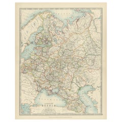
Antique Map of European Russia, 1903, with Colorful Provincial Boundaries
Title: Antique Map of European Russia, 1903, with Colorful Provincial Boundaries
Description:
This antique map, titled "European Russia," was engraved and published in 1903 by W. & ...
Kategorie
Frühes 20. Jahrhundert, Landkarten
Materialien
Papier
Antique Map of Ireland, 1903, with Intricate County Boundaries & Coastal Details
Title: Antique Map of Ireland, 1903, with Intricate County Boundaries and Coastal Detail
Description:
This antique map of Ireland, engraved and published in 1903 by the esteemed W. ...
Kategorie
Frühes 20. Jahrhundert, Landkarten
Materialien
Papier

Antique Map of Europe, 1903, with Intricate Political Boundaries and Rich Detail
Title: Antique Map of Europe, 1903, with Intricate Political Boundaries and Rich Detail
Description:
This antique map, titled "Europe," is a finely engraved and beautifully colored ...
Kategorie
Frühes 20. Jahrhundert, Landkarten
Materialien
Papier

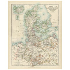
Antique Map of Denmark and German Empire Regions, 1903, Intricate and Colorful
Title: Antique Map of Denmark and German Empire Regions, 1903, Intricate and Colorful
Description:
This antique map, titled "Denmark with North West Portions of the German Empire," ...
Kategorie
Frühes 20. Jahrhundert, Landkarten
Materialien
Papier
Antique Map of the German Empire, 1903, Northern Portion with Coastal and Inland
Title: Antique Map of the German Empire, 1903, Northern Portion with Coastal and Inland Detail
Description:
This antique map, titled "Empire of Germany (Northern Portion)," was engr...
Kategorie
Frühes 20. Jahrhundert, Landkarten
Materialien
Papier

Das könnte Ihnen auch gefallen
Original Antike Karte des amerikanischen Staates Minnesota, 1903
Antike Karte von Minnesota
Veröffentlicht von A & C Black. 1903
Original Farbe
Guter Zustand
Ungerahmt.
Kostenloser Versand
Kategorie
Antik, Frühes 20. Jhdt., Englisch, Landkarten
Materialien
Papier

Original Antike Karte des amerikanischen Staates Alabama, 1903
Antique map of Alabama
Published By A & C Black. 1903
Original colour
Good condition
Unframed.
Free shipping
Kategorie
Antik, Frühes 20. Jhdt., Englisch, Landkarten
Materialien
Papier

Original Antike Karte des amerikanischen Staates Alaska, 1903
Antike Karte von Alaska
Veröffentlicht von A & C Black. 1903
Original Farbe
Guter Zustand
Ungerahmt.
Kostenloser Versand
Kategorie
Antik, Frühes 20. Jhdt., Englisch, Landkarten
Materialien
Papier

Original Antike Karte des amerikanischen Staates Nebraska, 1903
Antike Karte von Nebraska
Veröffentlicht von A & C Black. 1903
Original Farbe
Guter Zustand
Ungerahmt.
Kostenloser Versand
Kategorie
Antik, Frühes 20. Jhdt., Englisch, Landkarten
Materialien
Papier

Antike Karte des amerikanischen Staates Washington, 1903
Antike Karte von Washington
Veröffentlicht von A & C Black. 1903
Original Farbe
Guter Zustand
Ungerahmt.
Kostenloser Versand
Kategorie
Antik, Frühes 20. Jhdt., Englisch, Landkarten
Materialien
Papier

Original Antike Karte des amerikanischen Staates Tennessee, 1903
Antique map of Tennessee
Published By A & C Black. 1903
Original colour
Good condition
Unframed.
Free shipping
Kategorie
Antik, Frühes 20. Jhdt., Englisch, Landkarten
Materialien
Papier
