Objekte ähnlich wie Antique Map of the Northeast USA - Vibrant 1903 Cartographic Detail
Möchten Sie mehr Bilder oder Videos?
Zusätzliche Bilder oder Videos von dem*der Anbieter*in anfordern
1 von 10
Antique Map of the Northeast USA - Vibrant 1903 Cartographic Detail
Angaben zum Objekt
Map of the Northeastern United States of North America, 1903
This striking antique map titled “United States of North America (North Eastern Sheet)” was created by the renowned Scottish cartographer Keith Johnston and published in 1903. It captures the northeastern portion of the United States, including states such as New York, Pennsylvania, New Jersey, New England, and parts of the Midwest like Ohio and Indiana. With its fine engraving and hand-colored boundaries, this map offers a vivid snapshot of America’s bustling northeastern corridor at the turn of the century.
Notable features include major cities such as New York, Boston, and Philadelphia, as well as detailed renderings of the Great Lakes region, showcasing Lake Michigan, Lake Erie, and Lake Ontario with exceptional precision. The map’s inset of Maine provides additional geographical context for the northernmost reaches of this region, along with a clear delineation of rivers, railways, and mountain ranges. The typography is both elegant and easy to read, displaying Johnston’s trademark clarity and meticulous attention to detail.
The map’s condition is very good to excellent, with a clean impression and minimal age-related toning, adding character without compromising legibility. It’s a wonderful example of the craftsmanship that defined early 20th-century cartography and a superb item for collectors and history enthusiasts.
For framing, consider using a classic wooden or dark frame to complement the antique colors and highlight the intricate details. A neutral matting will help draw the eye to the delicate engraved lines and fine coloration, making this piece an attractive addition to any study, library, or home gallery.
- Maße:Höhe: 36,8 cm (14,49 in)Breite: 47 cm (18,51 in)Tiefe: 0,2 mm (0,01 in)
- Materialien und Methoden:
- Zeitalter:
- Herstellungsjahr:1903
- Zustand:The map’s condition is excellent, with a clean impression and minimal age-related toning, adding character without compromising legibility.
- Anbieterstandort:Langweer, NL
- Referenznummer:Anbieter*in: BG-13577-451stDibs: LU3054345291742
Anbieterinformationen
5,0
Anerkannte Anbieter*innen
Diese renommierten Anbieter*innen sind führend in der Branche und repräsentieren die höchste Klasse in Sachen Qualität und Design.
Gold-Anbieter*in
Premium-Anbieter*innen mit einer Bewertung über 4,3 und 24 Stunden Reaktionszeit
Gründungsjahr 2009
1stDibs-Anbieter*in seit 2017
2.462 Verkäufe auf 1stDibs
Typische Antwortzeit: <1 Stunde
- VersandAngebot wird abgerufen …Versand von: Langweer, Niederlande
- Rückgabebedingungen
Einige Inhalte dieser Seite wurden automatisch übersetzt. Daher kann 1stDibs nicht die Richtigkeit der Übersetzungen garantieren. Englisch ist die Standardsprache dieser Website.
Authentizitätsgarantie
Im unwahrscheinlichen Fall eines Problems mit der Echtheit eines Objekts kontaktieren Sie uns bitte innerhalb von 1 Jahr für eine volle Rückerstattung. DetailsGeld-Zurück-Garantie
Wenn Ihr Objekt nicht der Beschreibung entspricht, beim Transport beschädigt wurde oder nicht ankommt, kontaktieren Sie uns bitte innerhalb von 7 Tagen für eine vollständige Rückerstattung. DetailsStornierung innerhalb von 24 Stunden
Sie können Ihren Kauf jederzeit innerhalb von 24 Stunden stornieren, ohne jegliche Gründe dafür angeben zu müssen.Geprüfte Anbieter*innen
Unsere Anbieter*innen unterliegen strengen Dienstleistungs- und Qualitätsstandards, wodurch wir die Seriosität unserer Angebote gewährleisten können.Preisgarantie
Wenn Sie feststellen, dass ein*e Anbieter*in dasselbe Objekt anderswo zu einem niedrigeren Preis anbietet, werden wir den Preis entsprechend anpassen.Zuverlässige weltweite Lieferung
Unsere erstklassigen Versandunternehmen bieten spezielle Versandoptionen weltweit, einschließlich individueller Lieferung.Mehr von diesem*dieser Anbieter*in
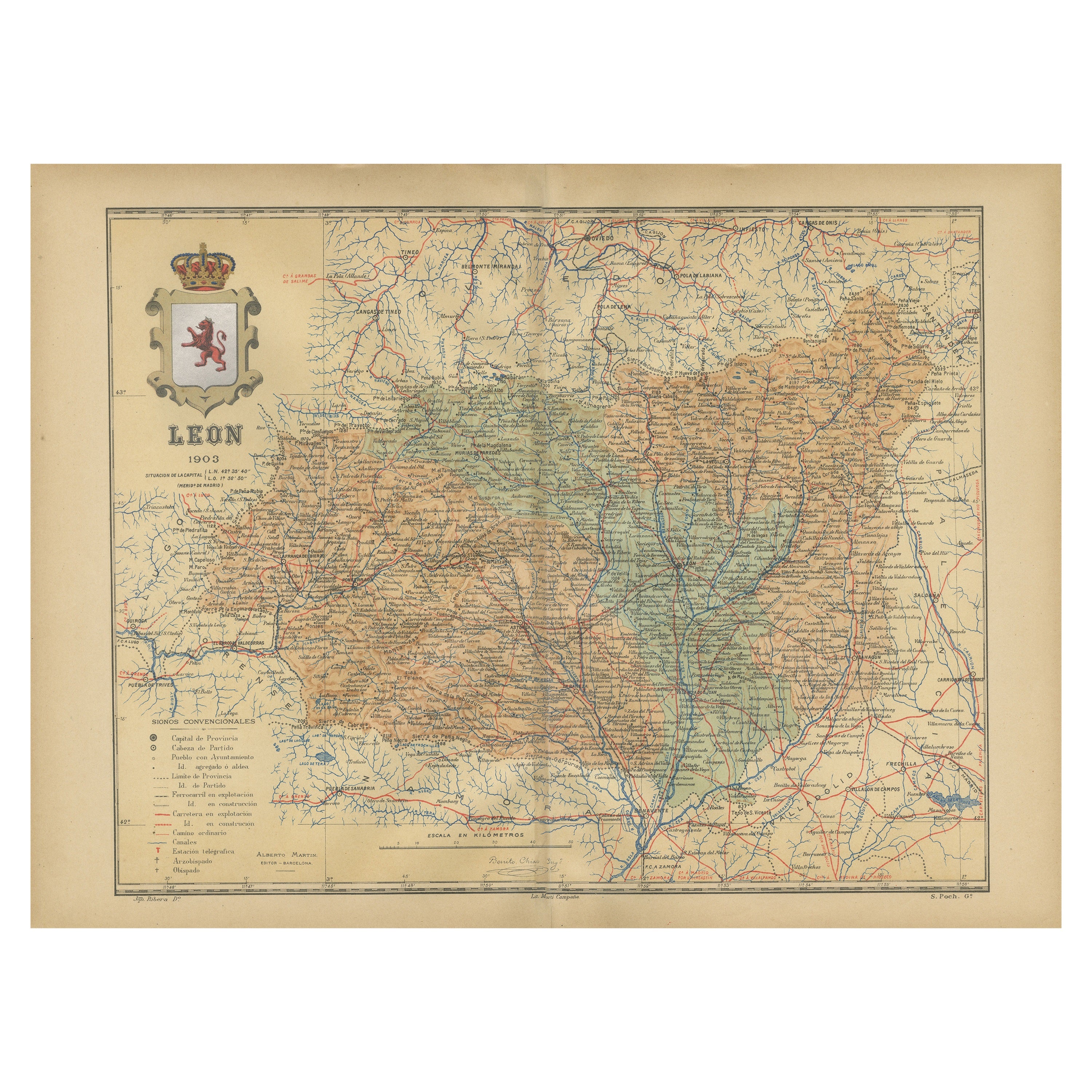
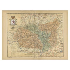
Alle anzeigenLeón 1903: Eine kartografische Darstellung der Bergprovinz von Kastilien und León
Die Karte zeigt die Provinz León, die im Nordwesten Spaniens liegt und seit 1903 zur autonomen Gemeinschaft Kastilien-León gehört. Bemerkenswerte Merkmale der Karte sind:
- **Topogr...
Kategorie
Antik, Frühes 20. Jhdt., Landkarten
Materialien
Papier
269 $ Angebotspreis
20 % Rabatt
Kostenloser Versand
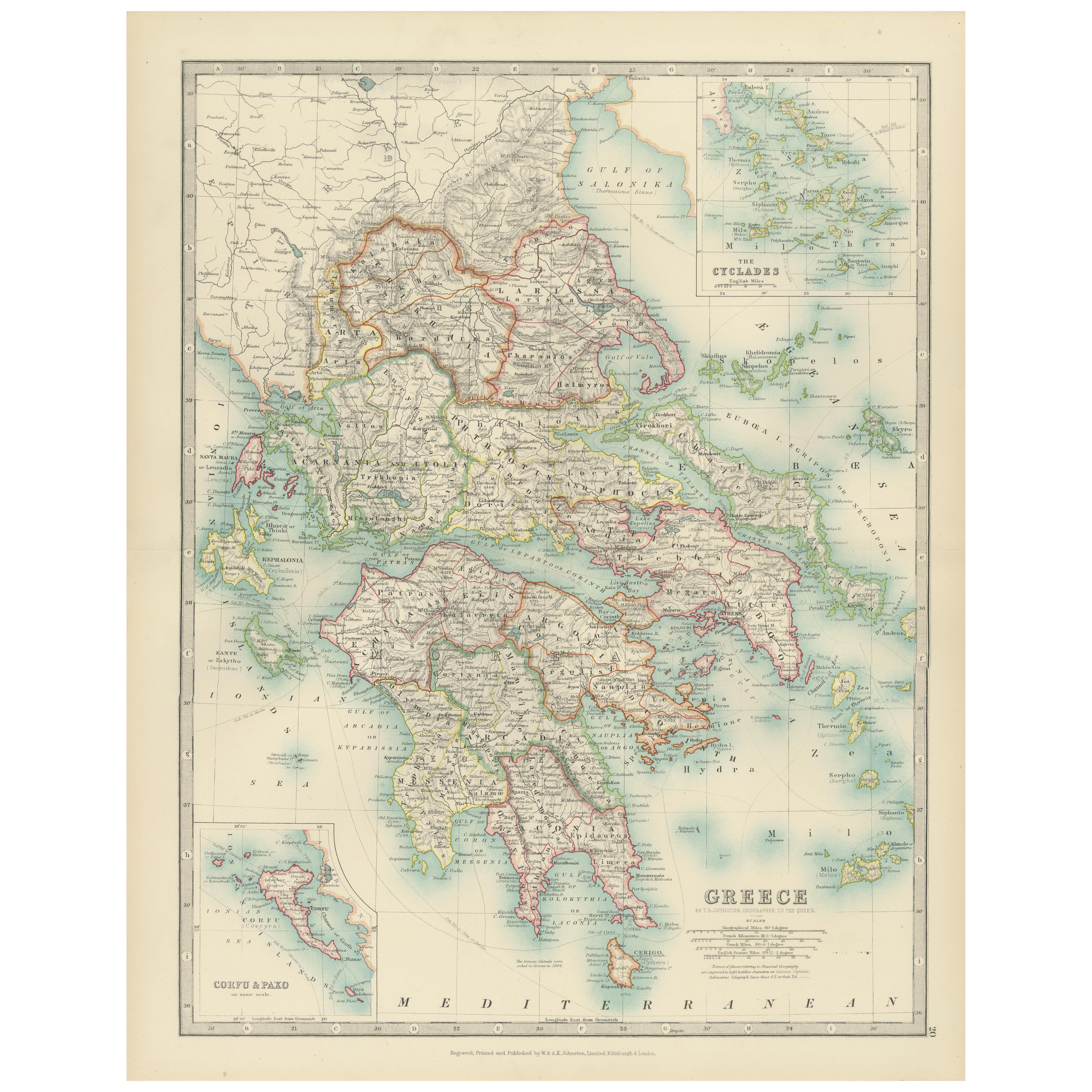
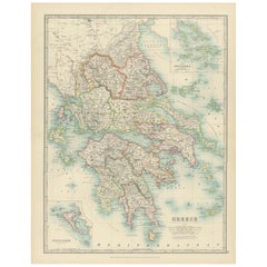
Antique Map of Greece and the Cyclades, 1903, with Many Details and Inset Maps
Title: Antique Map of Greece and the Cyclades, 1903, with Intricate Detail and Inset Maps
Description: This antique map, titled "Greece with Its Islands, Including the Cyclades," wa...
Kategorie
Frühes 20. Jahrhundert, Landkarten
Materialien
Papier
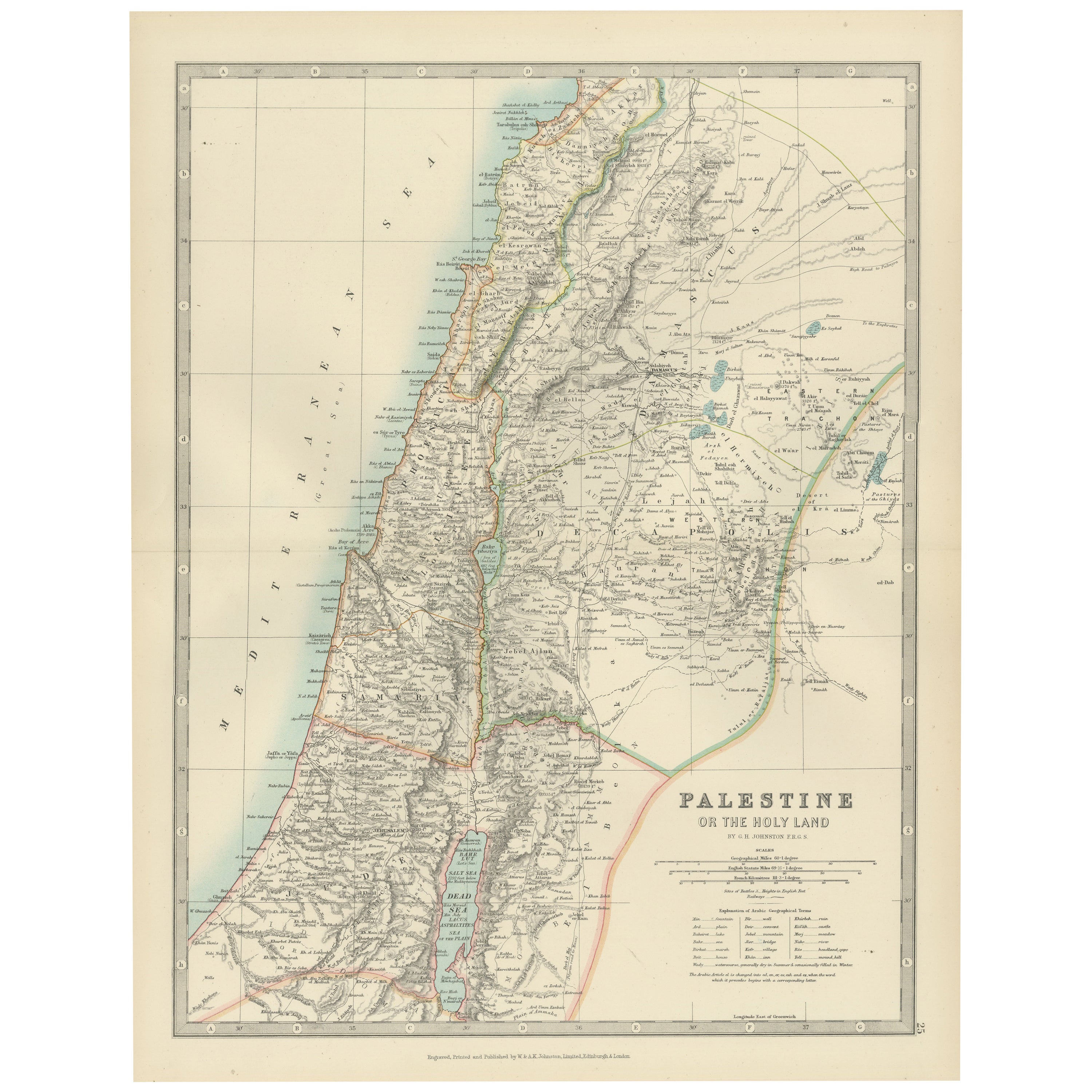
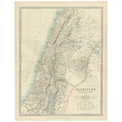
Antique Map of Palestine or The Holy Land, 1903, with Biblical Details
Title: Antique Map of Palestine or The Holy Land, 1903, with Biblical and Geographical Details
Description:
This antique map, titled "Palestine or The Holy Land," was engraved and p...
Kategorie
Frühes 20. Jahrhundert, Landkarten
Materialien
Papier
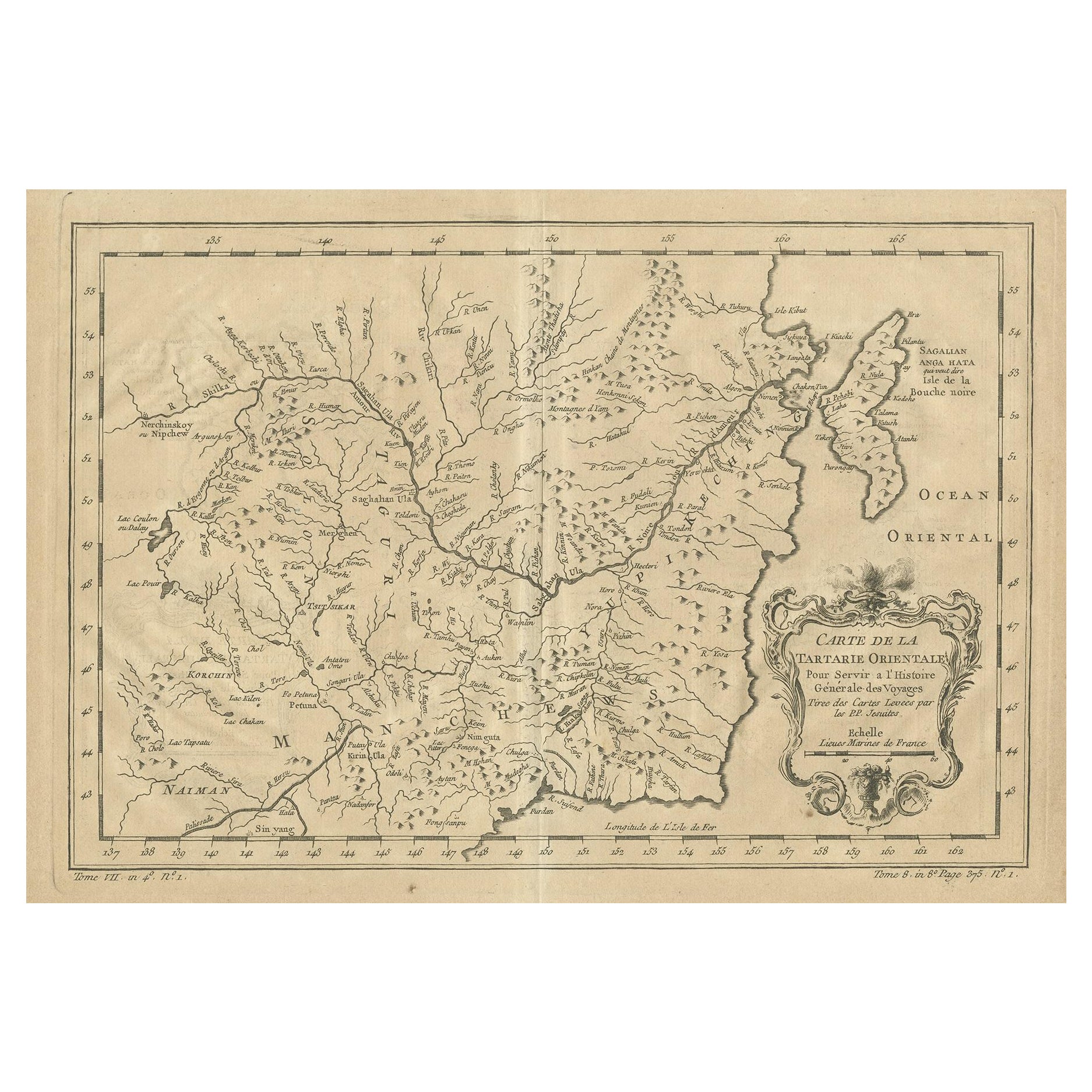
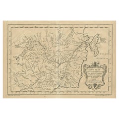
Antike Karte der Mandschurei und des nordöstlichen Teils von Tartary
Antike Karte mit dem Titel 'Carte de la Tartarie Orientale (..)'. Detaillierte Karte der Mandschurei und des nordöstlichen Teils der Tartaren, einschließlich Sagallan Anga Hata--Isle...
Kategorie
Antik, Mitte des 18. Jahrhunderts, Landkarten
Materialien
Papier
269 $ Angebotspreis
20 % Rabatt
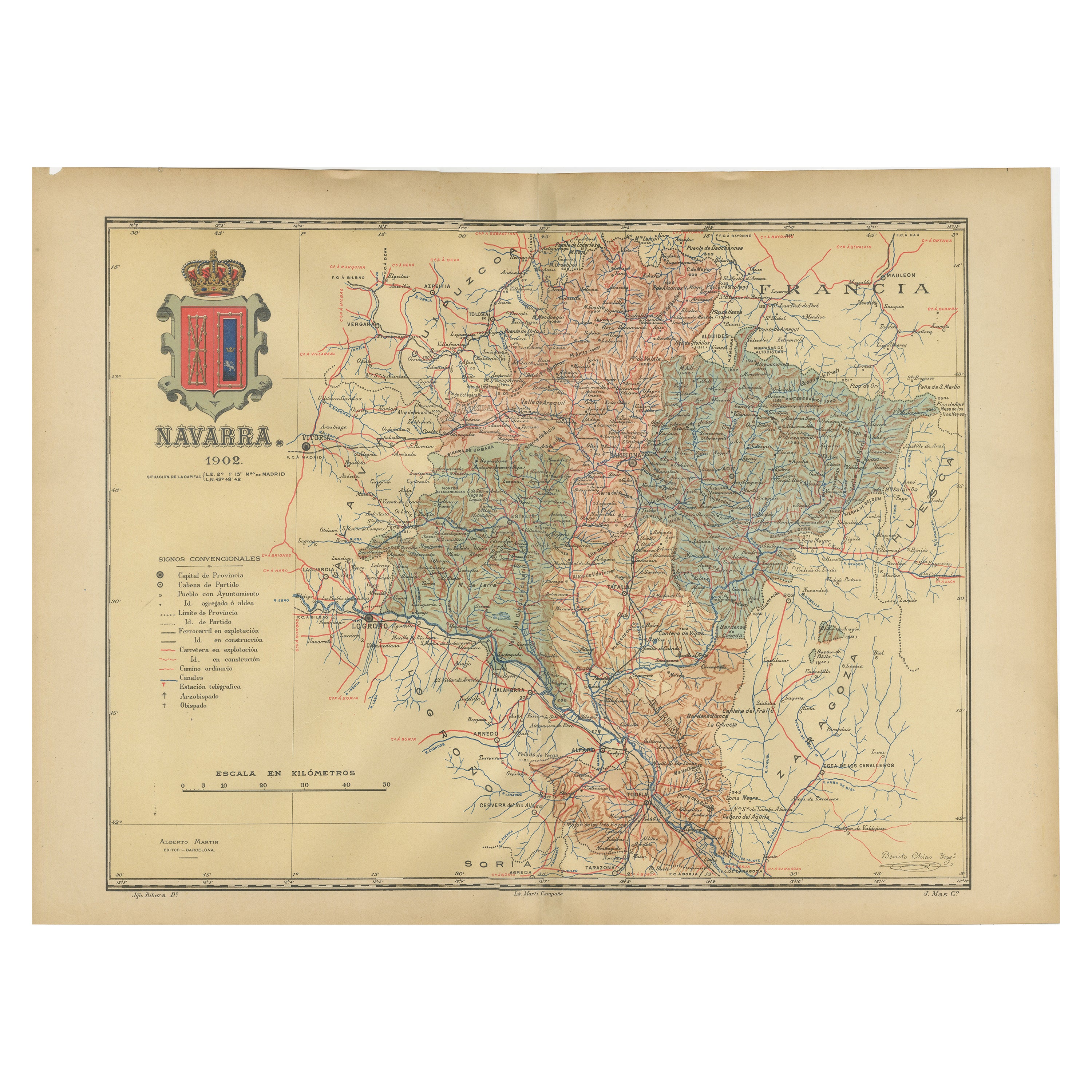
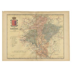
Navarra in Kartographischem Detail: Eine Karte der Küsten Nordspaniens aus dem Jahr 1902
Die zum Verkauf stehende antike Originalkarte zeigt die spanische Provinz Navarra im Zustand von 1902. Hier ist eine kurze Beschreibung und ein möglicher Titel für die Karte:
Beschr...
Kategorie
Antik, Frühes 20. Jhdt., Landkarten
Materialien
Papier
316 $ Angebotspreis
20 % Rabatt
Kostenloser Versand
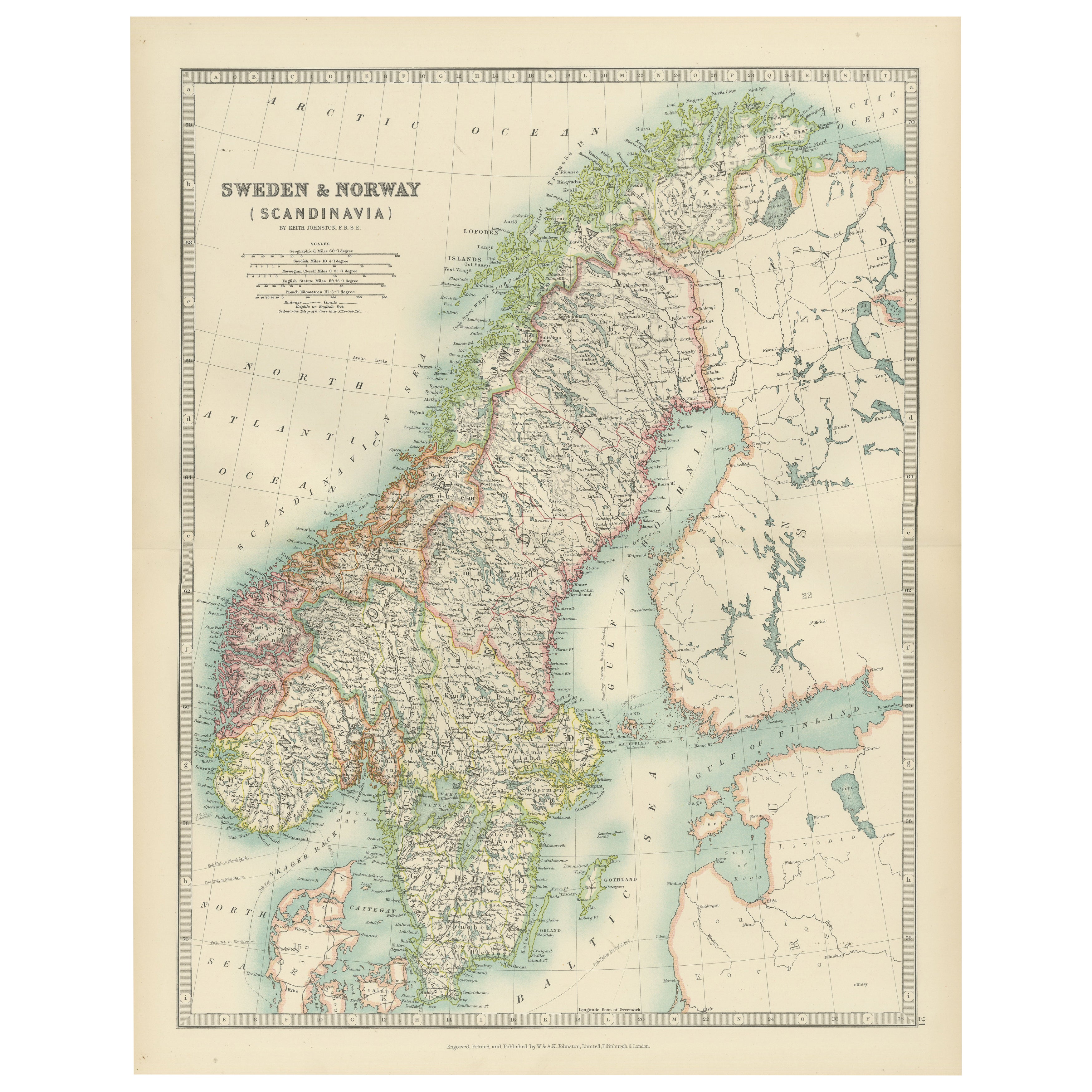
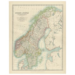
Antique Map of Sweden & Norway, 1903, with Intricate Topographical Detail
Title: Antique Map of Sweden & Norway, 1903, with Intricate Topographical Detail
Description:
This antique map, titled "Sweden & Norway (Scandinavia)," was engraved and published in...
Kategorie
Frühes 20. Jahrhundert, Landkarten
Materialien
Papier
Das könnte Ihnen auch gefallen
Antike Nordamerikakarte, USA, Kanada, Mexiko, Cartografie, Colton, viktorianisch
Dies ist eine antike Karte von Nordamerika. Gerahmter Lithografie-Atlas der USA von JH Colton aus der viktorianischen Zeit und später, um 1860.
Faszinierende, große gerahmte Karte ...
Kategorie
Antik, Mittleres 19. Jahrhundert, amerikanisch, Viktorianisch, Landkarten
Materialien
Papier

Original Antike Karte des amerikanischen Staates Minnesota, 1903
Antike Karte von Minnesota
Veröffentlicht von A & C Black. 1903
Original Farbe
Guter Zustand
Ungerahmt.
Kostenloser Versand
Kategorie
Antik, Frühes 20. Jhdt., Englisch, Landkarten
Materialien
Papier

Original Antike Karte des amerikanischen Staates Alabama, 1903
Antique map of Alabama
Published By A & C Black. 1903
Original colour
Good condition
Unframed.
Free shipping
Kategorie
Antik, Frühes 20. Jhdt., Englisch, Landkarten
Materialien
Papier

Original Antike Karte des amerikanischen Staates Alaska, 1903
Antike Karte von Alaska
Veröffentlicht von A & C Black. 1903
Original Farbe
Guter Zustand
Ungerahmt.
Kostenloser Versand
Kategorie
Antik, Frühes 20. Jhdt., Englisch, Landkarten
Materialien
Papier

Original Antike Karte des amerikanischen Staates Nebraska, 1903
Antike Karte von Nebraska
Veröffentlicht von A & C Black. 1903
Original Farbe
Guter Zustand
Ungerahmt.
Kostenloser Versand
Kategorie
Antik, Frühes 20. Jhdt., Englisch, Landkarten
Materialien
Papier

Antike Karte des amerikanischen Staates Washington, 1903
Antike Karte von Washington
Veröffentlicht von A & C Black. 1903
Original Farbe
Guter Zustand
Ungerahmt.
Kostenloser Versand
Kategorie
Antik, Frühes 20. Jhdt., Englisch, Landkarten
Materialien
Papier
