Objekte ähnlich wie Explore North America in 1903 - Intricately Detailed Antique Map


Möchten Sie mehr Bilder oder Videos?
Zusätzliche Bilder oder Videos von dem*der Anbieter*in anfordern
1 von 10
Explore North America in 1903 - Intricately Detailed Antique Map
Angaben zum Objekt
North America, 1903 - A Colorful Historical Map with Detailed Borders
This attractive map of North America was engraved, printed, and published by W. & A.K. Johnston in 1903. A wonderful example of early 20th-century cartography, it captures the complex geography and political divisions of Canada, the United States, Mexico, Central America, the Caribbean, and the Arctic regions in a detailed and colorful presentation.
The map is filled with fascinating details, including major cities, rivers, mountain ranges, and railway lines that crisscrossed the continent at the time. Political boundaries are clearly marked in different colors, distinguishing the various countries and regions. The northern reaches of Canada and Alaska are depicted with impressive accuracy for the era, as are the Caribbean islands and Central American states.
The bright yet subtle color palette—red for borders, blue for water, and a gentle green for mountain shading—makes this map visually appealing and easy to read. The map also includes detailed insets and a clear legend showing the scale and distances, making it a valuable reference for historians and collectors interested in the evolution of North America’s borders.
Condition report:
This map is in very good condition, with some minor foxing and small creases typical of antique maps. The paper is strong, and the colors remain clear and vibrant.
Framing tips:
This historical map would look splendid in a black or dark wood frame, perhaps with a white or cream mat to highlight the soft colors. A museum-quality glass can protect the map while preserving the crisp details and ensuring a long-lasting display in an office, library, or living room.
- Maße:Höhe: 47 cm (18,51 in)Breite: 36,8 cm (14,49 in)Tiefe: 0,2 mm (0,01 in)
- Materialien und Methoden:
- Zeitalter:
- Herstellungsjahr:1903
- Zustand:This map is in very good condition, with some minor foxing and small creases typical of antique maps. The paper is strong, and the colors remain clear and vibrant.
- Anbieterstandort:Langweer, NL
- Referenznummer:Anbieter*in: BG-13577-401stDibs: LU3054345291442
Anbieterinformationen
5,0
Anerkannte Anbieter*innen
Diese renommierten Anbieter*innen sind führend in der Branche und repräsentieren die höchste Klasse in Sachen Qualität und Design.
Gold-Anbieter*in
Premium-Anbieter*innen mit einer Bewertung über 4,3 und 24 Stunden Reaktionszeit
Gründungsjahr 2009
1stDibs-Anbieter*in seit 2017
2.462 Verkäufe auf 1stDibs
Typische Antwortzeit: <1 Stunde
- VersandAngebot wird abgerufen …Versand von: Langweer, Niederlande
- Rückgabebedingungen
Einige Inhalte dieser Seite wurden automatisch übersetzt. Daher kann 1stDibs nicht die Richtigkeit der Übersetzungen garantieren. Englisch ist die Standardsprache dieser Website.
Authentizitätsgarantie
Im unwahrscheinlichen Fall eines Problems mit der Echtheit eines Objekts kontaktieren Sie uns bitte innerhalb von 1 Jahr für eine volle Rückerstattung. DetailsGeld-Zurück-Garantie
Wenn Ihr Objekt nicht der Beschreibung entspricht, beim Transport beschädigt wurde oder nicht ankommt, kontaktieren Sie uns bitte innerhalb von 7 Tagen für eine vollständige Rückerstattung. DetailsStornierung innerhalb von 24 Stunden
Sie können Ihren Kauf jederzeit innerhalb von 24 Stunden stornieren, ohne jegliche Gründe dafür angeben zu müssen.Geprüfte Anbieter*innen
Unsere Anbieter*innen unterliegen strengen Dienstleistungs- und Qualitätsstandards, wodurch wir die Seriosität unserer Angebote gewährleisten können.Preisgarantie
Wenn Sie feststellen, dass ein*e Anbieter*in dasselbe Objekt anderswo zu einem niedrigeren Preis anbietet, werden wir den Preis entsprechend anpassen.Zuverlässige weltweite Lieferung
Unsere erstklassigen Versandunternehmen bieten spezielle Versandoptionen weltweit, einschließlich individueller Lieferung.Mehr von diesem*dieser Anbieter*in
Alle anzeigenAntique Map of Asia with Intricate Provincial Boundaries, Published in 1903
Title: Antique Map of Asia, 1903, with Intricate Provincial Boundaries and Coastal Features
Description:
This antique map, titled "Asia," was engraved and published in 1903 by the r...
Kategorie
Frühes 20. Jahrhundert, Landkarten
Materialien
Papier

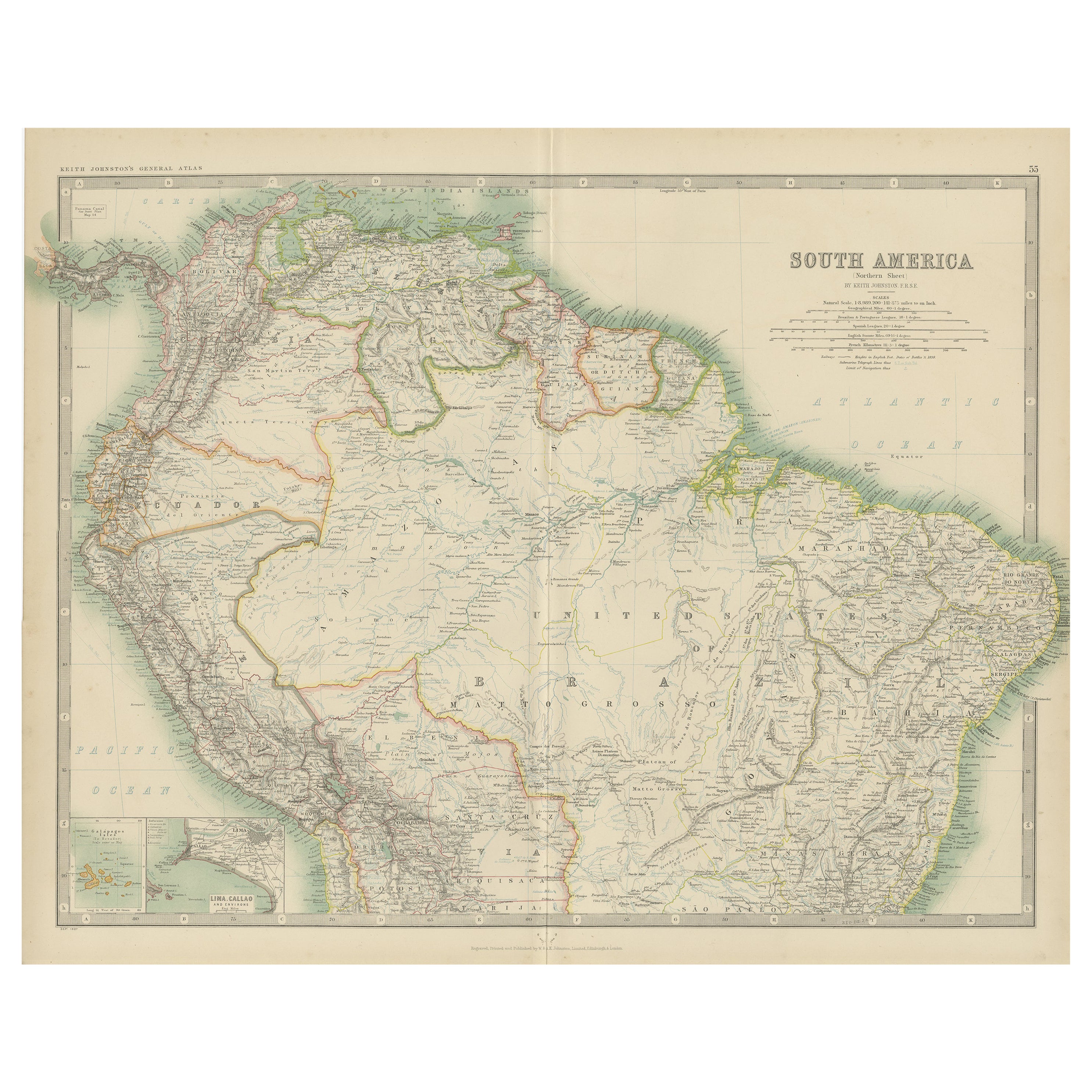
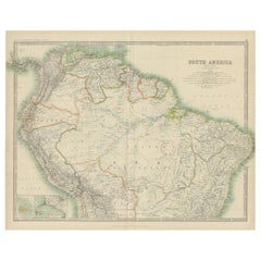
Erkunden Sie Südamerikas Nordamerikas: Antike Karte aus dem Royal Atlas von 1909
Die antike Karte mit dem Titel 'Südamerika, nördliches Blatt' ist eine historische kartografische Darstellung des nördlichen Teils von Südamerika. Diese originale antike Karte enthäl...
Kategorie
Frühes 20. Jahrhundert, Landkarten
Materialien
Papier
233 $ Angebotspreis
20 % Rabatt
Antique Map of Northern Scotland, 1903, with Intricate Coastal Features
Title: Antique Map of Northern Scotland and Islands, 1903, with Intricate Coastal Features
Description:
This striking antique map, titled "Scotland (Northern Sheet I)," was engraved...
Kategorie
Frühes 20. Jahrhundert, Landkarten
Materialien
Papier

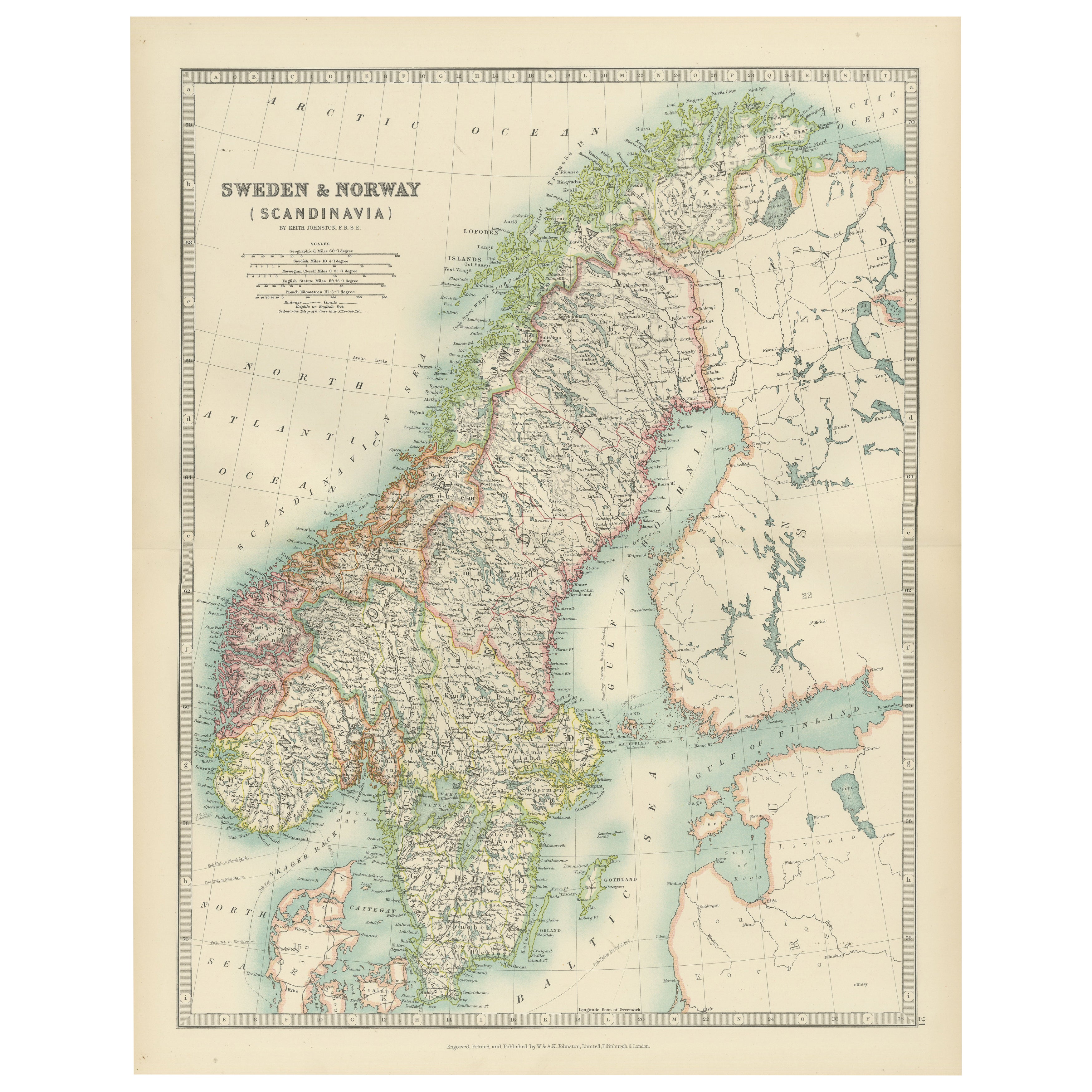
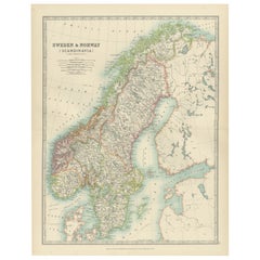
Antique Map of Sweden & Norway, 1903, with Intricate Topographical Detail
Title: Antique Map of Sweden & Norway, 1903, with Intricate Topographical Detail
Description:
This antique map, titled "Sweden & Norway (Scandinavia)," was engraved and published in...
Kategorie
Frühes 20. Jahrhundert, Landkarten
Materialien
Papier
Antike Karte Nordamerikas, 1821
Antike Karte von Amerika mit dem Titel 'Carte de l'Amerique septentrionale'. Seltene Karte von Nordamerika, kurz nach dem Louisiana Purchase und der ersten Veröffentlichung des offiz...
Kategorie
Antik, 19. Jahrhundert, Landkarten
Materialien
Papier

606 $ Angebotspreis
20 % Rabatt
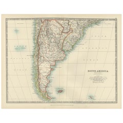
Map of Southern South America – Richly Detailed Engraving by K.Johnston, 1903
Title (80 characters, keyword-first):
Map of Southern South America – Richly Detailed Engraving by Keith Johnston, 1903
Description:
This elegant map titled "South America: Southern...
Kategorie
Frühes 20. Jahrhundert, Landkarten
Materialien
Papier
Das könnte Ihnen auch gefallen
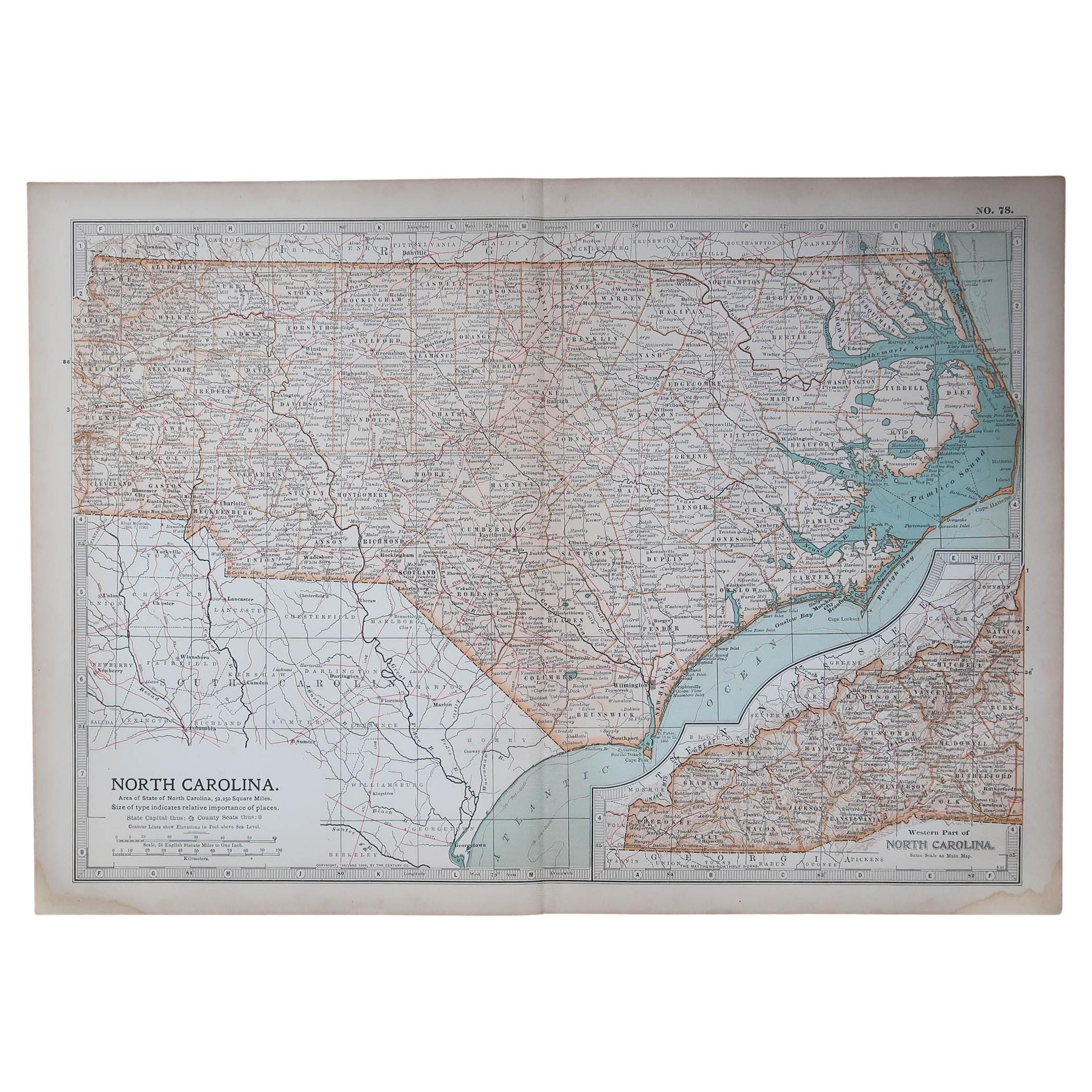
Original Antike Karte des amerikanischen Staates North Carolina, 1903
Antique map of North Carolina
Published By A & C Black. 1903
Original colour
Good condition
Unframed.
Free shipping
Kategorie
Antik, Frühes 20. Jhdt., Englisch, Landkarten
Materialien
Papier

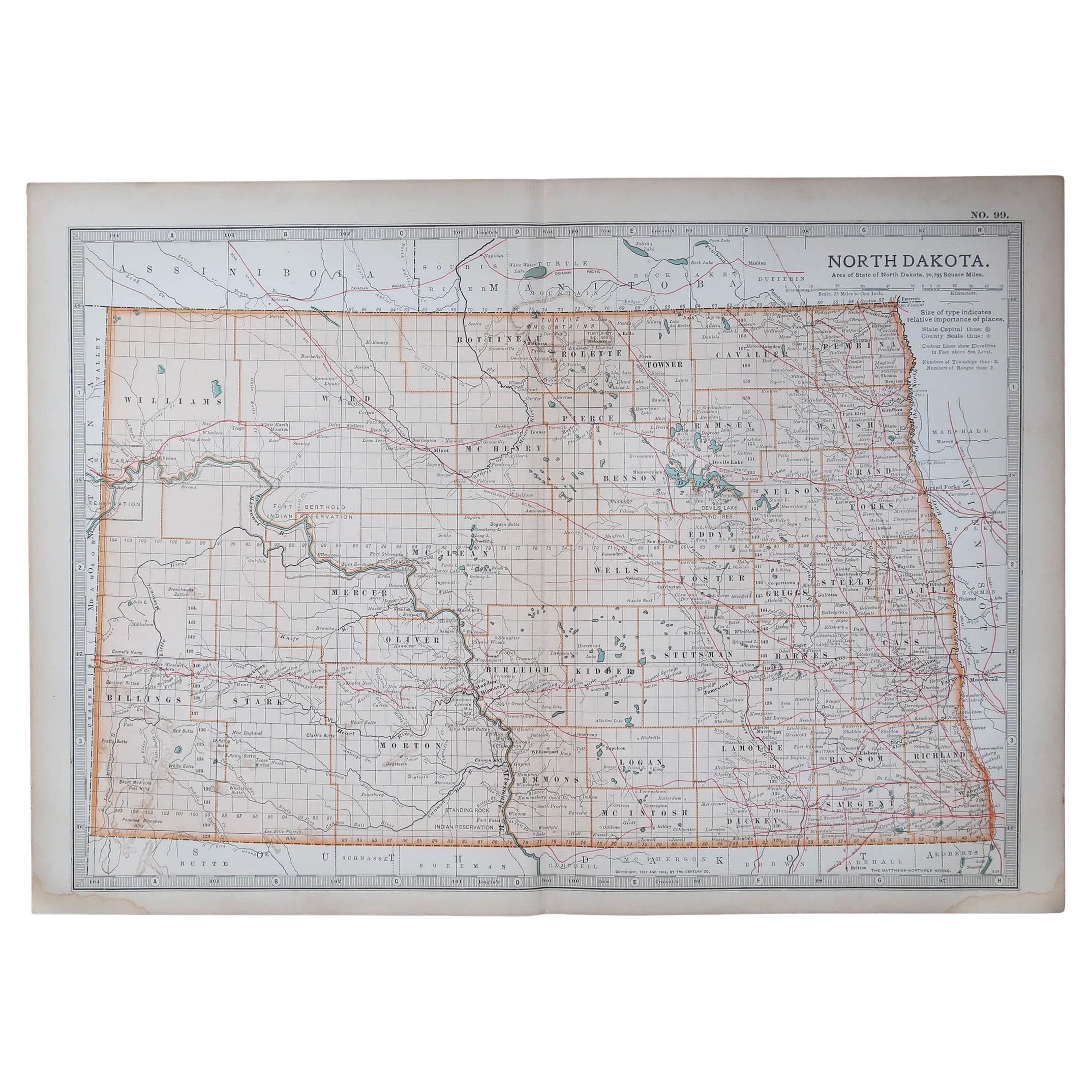
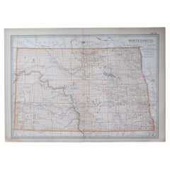
Original Antike Karte des amerikanischen Staates North Dakota, 1903
Antike Karte von North Dakota
Veröffentlicht von A & C Black. 1903
Original Farbe
Guter Zustand
Ungerahmt.
Kostenloser Versand
Kategorie
Antik, Frühes 20. Jhdt., Englisch, Landkarten
Materialien
Papier
Original Antike Karte des amerikanischen Staates Minnesota, 1903
Antike Karte von Minnesota
Veröffentlicht von A & C Black. 1903
Original Farbe
Guter Zustand
Ungerahmt.
Kostenloser Versand
Kategorie
Antik, Frühes 20. Jhdt., Englisch, Landkarten
Materialien
Papier

Original Antike Karte des amerikanischen Staates Alabama, 1903
Antique map of Alabama
Published By A & C Black. 1903
Original colour
Good condition
Unframed.
Free shipping
Kategorie
Antik, Frühes 20. Jhdt., Englisch, Landkarten
Materialien
Papier

Original Antike Karte des amerikanischen Staates Alaska, 1903
Antike Karte von Alaska
Veröffentlicht von A & C Black. 1903
Original Farbe
Guter Zustand
Ungerahmt.
Kostenloser Versand
Kategorie
Antik, Frühes 20. Jhdt., Englisch, Landkarten
Materialien
Papier

Original Antike Karte des amerikanischen Staates Nebraska, 1903
Antike Karte von Nebraska
Veröffentlicht von A & C Black. 1903
Original Farbe
Guter Zustand
Ungerahmt.
Kostenloser Versand
Kategorie
Antik, Frühes 20. Jhdt., Englisch, Landkarten
Materialien
Papier
