Objekte ähnlich wie Map of Aube France with Troyes and Champagne Wine Region, 19th Century


Möchten Sie mehr Bilder oder Videos?
Zusätzliche Bilder oder Videos von dem*der Anbieter*in anfordern
1 von 10
Map of Aube France with Troyes and Champagne Wine Region, 19th Century
120� €Einschließlich MwSt.
Angaben zum Objekt
Map of Aube France with Troyes and Champagne Vineyards by Vuillemin, 19th c
Description:
This 19th-century map of the Aube department in the Grand Est region of northeastern France was engraved by Alexandre Vuillemin and published by Migeon in Paris as part of the Nouvel Atlas Illustré. Combining fine cartography with historical and cultural illustration, the map offers a visual journey through one of France’s most historically rich and agriculturally significant regions.
Aube is part of the historic Champagne region, and the map clearly displays its towns, rivers, and roadways, all bordered in hand-applied pastel pink. The capital city of Troyes is prominently positioned at the center, surrounded by a dense network of communes. To the right, a finely engraved vignette shows the town of Nogent-sur-Seine, situated along the banks of the river, offering a calm and picturesque atmosphere.
Two prominent portraits are featured in the lower left corner: Denis Diderot, the Enlightenment philosopher and editor of the Encyclopédie, who was born in Langres just outside Aube but is associated with the regional intellectual landscape; and Georges Cuvier, a pioneering naturalist who laid the foundations for paleontology. Their inclusion highlights the region’s contribution to French intellectual and scientific advancement.
Aube plays a major role in France’s wine culture as part of the southern Champagne-producing area. The Côte des Bar, located in the southern part of Aube, is especially known for producing high-quality Pinot Noir grapes, crucial for blending in Champagne production. While less internationally known than the vineyards of Reims and Épernay to the north, the vineyards around Bar-sur-Seine and Bar-sur-Aube have gained increasing recognition for their elegant and expressive sparkling wines.
Alexandre Vuillemin was a leading 19th-century French cartographer celebrated for merging technical accuracy with decorative and educational value. His maps are valued today for their aesthetic qualities and insight into the political and cultural geography of the time. The publisher Migeon specialized in illustrated educational works, bringing finely engraved atlases to a broad audience.
Condition summary:
Very good condition with minimal toning and a few scattered foxing spots, mostly confined to the margins. Original hand coloring remains vibrant and the engraving is clear and sharp.
Framing tips:
This map pairs well with a dark or gold-toned frame. A soft beige or off-white mat will complement the pink border color and engraved details. Use UV-filtering glass for preservation and to maintain the crispness of the print.
- Maße:Höhe: 26,1 cm (10,28 in)Breite: 32,5 cm (12,8 in)Tiefe: 0,2 mm (0,01 in)
- Materialien und Methoden:Papier,Graviert
- Herkunftsort:
- Zeitalter:
- Herstellungsjahr:circa 1850
- Zustand:Very good condition with minimal toning and a few scattered foxing spots, mostly confined to the margins. Original hand coloring remains vibrant and the engraving is clear and sharp.
- Anbieterstandort:Langweer, NL
- Referenznummer:Anbieter*in: BG-13331-91stDibs: LU3054345359582
Anbieterinformationen
5,0
Anerkannte Anbieter*innen
Diese renommierten Anbieter*innen sind führend in der Branche und repräsentieren die höchste Klasse in Sachen Qualität und Design.
Platin-Anbieter*in
Premium-Anbieter*innen mit einer Bewertung über 4,7 und 24 Stunden Reaktionszeit
Gründungsjahr 2009
1stDibs-Anbieter*in seit 2017
2.654 Verkäufe auf 1stDibs
Typische Antwortzeit: <1 Stunde
- VersandAngebot wird abgerufen …Versand von: Langweer, Niederlande
- Rückgabebedingungen
Einige Inhalte dieser Seite wurden automatisch übersetzt. Daher kann 1stDibs nicht die Richtigkeit der Übersetzungen garantieren. Englisch ist die Standardsprache dieser Website.
Authentizitätsgarantie
Im unwahrscheinlichen Fall eines Problems mit der Echtheit eines Objekts kontaktieren Sie uns bitte innerhalb von 1 Jahr für eine volle Rückerstattung. DetailsGeld-Zurück-Garantie
Wenn Ihr Objekt nicht der Beschreibung entspricht, beim Transport beschädigt wurde oder nicht ankommt, kontaktieren Sie uns bitte innerhalb von 7 Tagen für eine vollständige Rückerstattung. DetailsStornierung innerhalb von 24 Stunden
Sie können Ihren Kauf jederzeit innerhalb von 24 Stunden stornieren, ohne jegliche Gründe dafür angeben zu müssen.Geprüfte Anbieter*innen
Unsere Anbieter*innen unterliegen strengen Dienstleistungs- und Qualitätsstandards, wodurch wir die Seriosität unserer Angebote gewährleisten können.Preisgarantie
Wenn Sie feststellen, dass ein*e Anbieter*in dasselbe Objekt anderswo zu einem niedrigeren Preis anbietet, werden wir den Preis entsprechend anpassen.Zuverlässige weltweite Lieferung
Unsere erstklassigen Versandunternehmen bieten spezielle Versandoptionen weltweit, einschließlich individueller Lieferung.Mehr von diesem*dieser Anbieter*in
Alle anzeigenMap of Allier France with Saint-Pourçain Wine Region by Vuillemin, 19th c
Map of Allier France with Saint-Pourçain Wine Region by Vuillemin, 19th c
This decorative 19th-century map of Allier, a central department of France, comes from the celebrated Nouve...
Kategorie
Antik, Mittleres 19. Jahrhundert, Französisch, Landkarten
Materialien
Papier

Map of Aisne France with Soissons and Champagne Vineyards by Vuillemin, 19th c
Map of Aisne France with Soissons and Champagne Vineyards by Vuillemin, 19th c
Description:
This richly detailed 19th-century engraved and hand-colored map of the department of Aisn...
Kategorie
Antik, Mittleres 19. Jahrhundert, Französisch, Landkarten
Materialien
Papier

Map of Côtes-du-Nord France with Saint-Brieuc and Brittany Coastline, c.1850
Map of Côtes-du-Nord France with Saint-Brieuc and Brittany Coastline, 19th c
Description:
This elegant 19th-century map of Côtes-du-Nord, the historic name for what is now known as ...
Kategorie
Antik, Mittleres 19. Jahrhundert, Französisch, Landkarten
Materialien
Papier

Map of Gers France with Auch and Armagnac Wine Region by Vuillemin, 19th c
Map of Gers France with Auch and Armagnac Wine Region by Vuillemin, 19th c
This 19th-century engraved and hand-colored map of the department of Gers in southwestern France was creat...
Kategorie
Antik, Mittleres 19. Jahrhundert, Französisch, Landkarten
Materialien
Papier

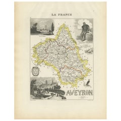
Map of Aveyron France with Rodez, Millau and Wine Routes, 19th Century
Map of Aveyron France with Rodez, Millau and Wine Routes, 19th Century
Description:
This detailed and decorative 19th-century map of Aveyron, a department in southern France, was dr...
Kategorie
Antik, Mittleres 19. Jahrhundert, Französisch, Landkarten
Materialien
Papier
Map of Ain France with Vineyards of Bugey and Notable Portraits, c.1850
Map of Ain France with Portraits of Bichat and Joubert by Vuillemin, 19th c
This highly decorative 19th-century map of the French department of Ain is taken from the celebrated Nouv...
Kategorie
Antik, Mittleres 19. Jahrhundert, Französisch, Landkarten
Materialien
Papier

Das könnte Ihnen auch gefallen
Beinahe Frankreich. Antike Karte einer französischen Abteilung, 1856
Von Victor Levasseur
dept. de L'Aube", Stahlstich mit originaler Handkolorierung der Umrisse, 1856, aus dem "Atlas National Illustre" von Levasseur.
Diese Region Frankreichs ist bekannt für die Herstel...
Kategorie
19. Jahrhundert, Naturalismus, Landschaftsdrucke
Materialien
Gravur

Aude, Frankreich. Antike Karte einer französischen Abteilung, 1856
Von Victor Levasseur
dept. de L' Aude", Stahlstich mit Originalumriss von Hand koloriert, 1856, aus Levasseurs "Atlas National Illustre".
Diese Region Frankreichs ist berühmt für ihre große Vielfalt an...
Kategorie
19. Jahrhundert, Naturalismus, Landschaftsdrucke
Materialien
Gravur

Große Karte von Frankreich aus dem 19.
Große Karte von Frankreich aus dem 19. Jahrhundert.
Bemerkenswerter Zustand, mit einer angenehmen altersbedingten Patina.
Kürzlich gerahmt.
Frankreich CIRCA 1874.
Kategorie
Antik, Spätes 19. Jahrhundert, Französisch, Landkarten
Materialien
Leinen, Papier

Anlehnung an Loire und Loire, Frankreich. Antike Karte einer französischen Abteilung, 1856
Von Victor Levasseur
dept. de Saone et Loire", Stahlstich mit originaler Handkolorierung der Umrisse, 1856, aus: Atlas National Illustre von Levasseur.
Das französische Departement Saone et Loire ist d...
Kategorie
19. Jahrhundert, Naturalismus, Landschaftsdrucke
Materialien
Gravur

Indre und Loire, Frankreich. Antike Karte einer französischen Abteilung, 1856
Von Victor Levasseur
dept. d'Indre et Loire", Stahlstich mit Originalumriss von Hand koloriert, 1856, aus Levasseurs "Atlas National Illustre".
Dieses Gebiet ist bekannt für die Herstellung von Chenin ...
Kategorie
19. Jahrhundert, Naturalismus, Landschaftsdrucke
Materialien
Gravur

1771 Bonne Karte von Poitou, Touraine und Anjou, Frankreich, Ric.a015
1771 Bonne-Karte von Poitou,
Touraine und Anjou, Frankreich
Ric.a015
1771 Bonne-Karte von Potiou, Touraine und Anjou mit dem Titel "Carte des Gouvernements D'Anjou et du Sau...
Kategorie
Antik, 17. Jahrhundert, Unbekannt, Landkarten
Materialien
Papier
