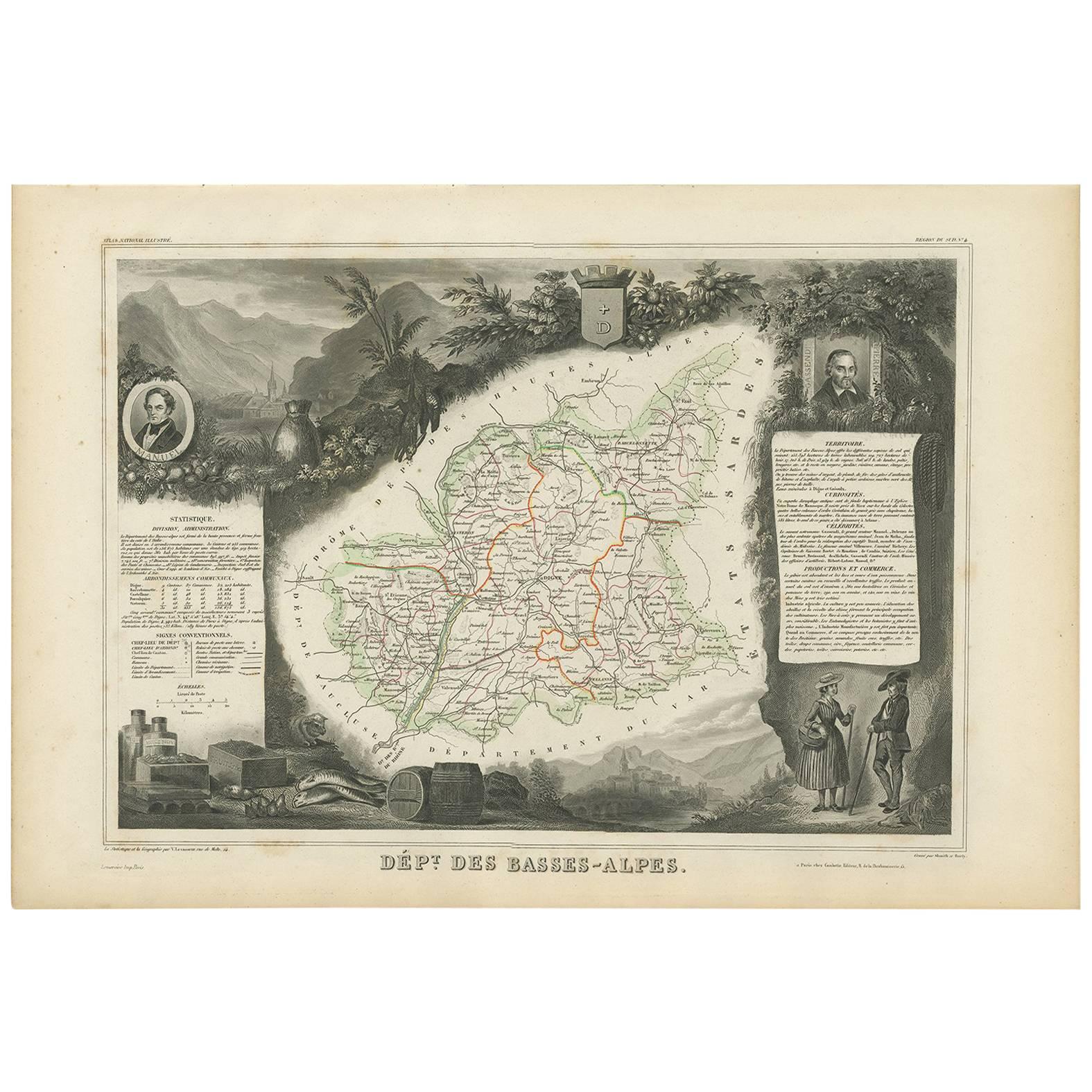
Objekte ähnlich wie Map of Basses-Alpes France with Digne and Lavender Region by Vuillemin, c.1850


Möchten Sie mehr Bilder oder Videos?
Zusätzliche Bilder oder Videos von dem*der Anbieter*in anfordern
1 von 10
Map of Basses-Alpes France with Digne and Lavender Region by Vuillemin, c.1850
120 €Einschließlich MwSt.
Angaben zum Objekt
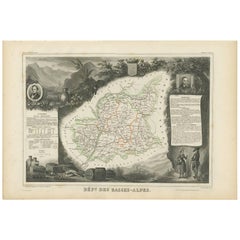
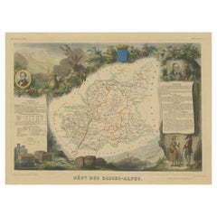
Map of Basses-Alpes France with Digne and Lavender Region by Vuillemin, 19th c
This finely engraved 19th-century map of the Basses-Alpes department of France (known today as Alpes-de-Haute-Provence) is from the renowned Nouvel Atlas Illustré by Alexandre Vuillemin, published by Migeon in Paris. It features delicate hand coloring, regional detail, and elegant vignettes that highlight the cultural and natural identity of the area.
The map outlines the department of Basses-Alpes with clear detail, showcasing towns, rivers, and roads, bordered in soft pastel colors. The mountains, passes, and valleys are rendered with precision, reflecting the department's alpine geography. In the upper left corner, a vignette depicts the town of Digne (now Digne-les-Bains), the administrative center of the department, with the Alps rising in the distance. The bottom left corner features a mountain goat resting on the rocks—an allusion to the region’s wildlife and rugged landscape. To the right, a portrait of Jean-Baptiste Gassendi, philosopher, astronomer, and native of the region, brings historical depth to the composition. Birds flying along the right edge further emphasize the natural richness of the region.
Basses-Alpes is particularly renowned for its stunning lavender fields, which blanket the landscape in purple during summer months. This region, especially the areas around Digne, Forcalquier, and Valensole, is one of the key sources of French lavender, used in perfumes, soaps, and essential oils. In addition to lavender, the region also produces honey, olives, and wines from the Vin de Pays des Alpes-de-Haute-Provence designation.
Alexandre Vuillemin, the cartographer, was a noted 19th-century French mapmaker whose decorative atlases combined geography with culture and art. His publisher, Migeon, specialized in beautifully illustrated educational works. Together, they produced maps that were both informative and visually compelling, popular among scholars and collectors alike.
Condition summary:
Very good condition with slight toning to the margins and a few faint foxing spots, mostly in outer areas. The engraved details are sharp and the original hand-coloring remains clean and attractive.
Framing tips:
This map pairs beautifully with a medium or dark wood frame, or an antique gold moulding to highlight the historic charm. A soft cream or light lavender-toned mat can complement the regional theme. UV-protective glass is recommended to ensure long-term preservation.
- Maße:Höhe: 26,1 cm (10,28 in)Breite: 32,5 cm (12,8 in)Tiefe: 0,2 mm (0,01 in)
- Materialien und Methoden:Papier,Graviert
- Herkunftsort:
- Zeitalter:
- Herstellungsjahr:circa 1850
- Zustand:Very good condition with slight toning to the margins and a few faint foxing spots, mostly in outer areas. The engraved details are sharp and the original hand-coloring remains clean and attractive.
- Anbieterstandort:Langweer, NL
- Referenznummer:Anbieter*in: BG-13331-41stDibs: LU3054345359142
Anbieterinformationen
5,0
Anerkannte Anbieter*innen
Diese renommierten Anbieter*innen sind führend in der Branche und repräsentieren die höchste Klasse in Sachen Qualität und Design.
Platin-Anbieter*in
Premium-Anbieter*innen mit einer Bewertung über 4,7 und 24 Stunden Reaktionszeit
Gründungsjahr 2009
1stDibs-Anbieter*in seit 2017
2.653 Verkäufe auf 1stDibs
Typische Antwortzeit: <1 Stunde
- VersandAngebot wird abgerufen …Versand von: Langweer, Niederlande
- Rückgabebedingungen
Einige Inhalte dieser Seite wurden automatisch übersetzt. Daher kann 1stDibs nicht die Richtigkeit der Übersetzungen garantieren. Englisch ist die Standardsprache dieser Website.
Authentizitätsgarantie
Im unwahrscheinlichen Fall eines Problems mit der Echtheit eines Objekts kontaktieren Sie uns bitte innerhalb von 1 Jahr für eine volle Rückerstattung. DetailsGeld-Zurück-Garantie
Wenn Ihr Objekt nicht der Beschreibung entspricht, beim Transport beschädigt wurde oder nicht ankommt, kontaktieren Sie uns bitte innerhalb von 7 Tagen für eine vollständige Rückerstattung. DetailsStornierung innerhalb von 24 Stunden
Sie können Ihren Kauf jederzeit innerhalb von 24 Stunden stornieren, ohne jegliche Gründe dafür angeben zu müssen.Geprüfte Anbieter*innen
Unsere Anbieter*innen unterliegen strengen Dienstleistungs- und Qualitätsstandards, wodurch wir die Seriosität unserer Angebote gewährleisten können.Preisgarantie
Wenn Sie feststellen, dass ein*e Anbieter*in dasselbe Objekt anderswo zu einem niedrigeren Preis anbietet, werden wir den Preis entsprechend anpassen.Zuverlässige weltweite Lieferung
Unsere erstklassigen Versandunternehmen bieten spezielle Versandoptionen weltweit, einschließlich individueller Lieferung.Mehr von diesem*dieser Anbieter*in
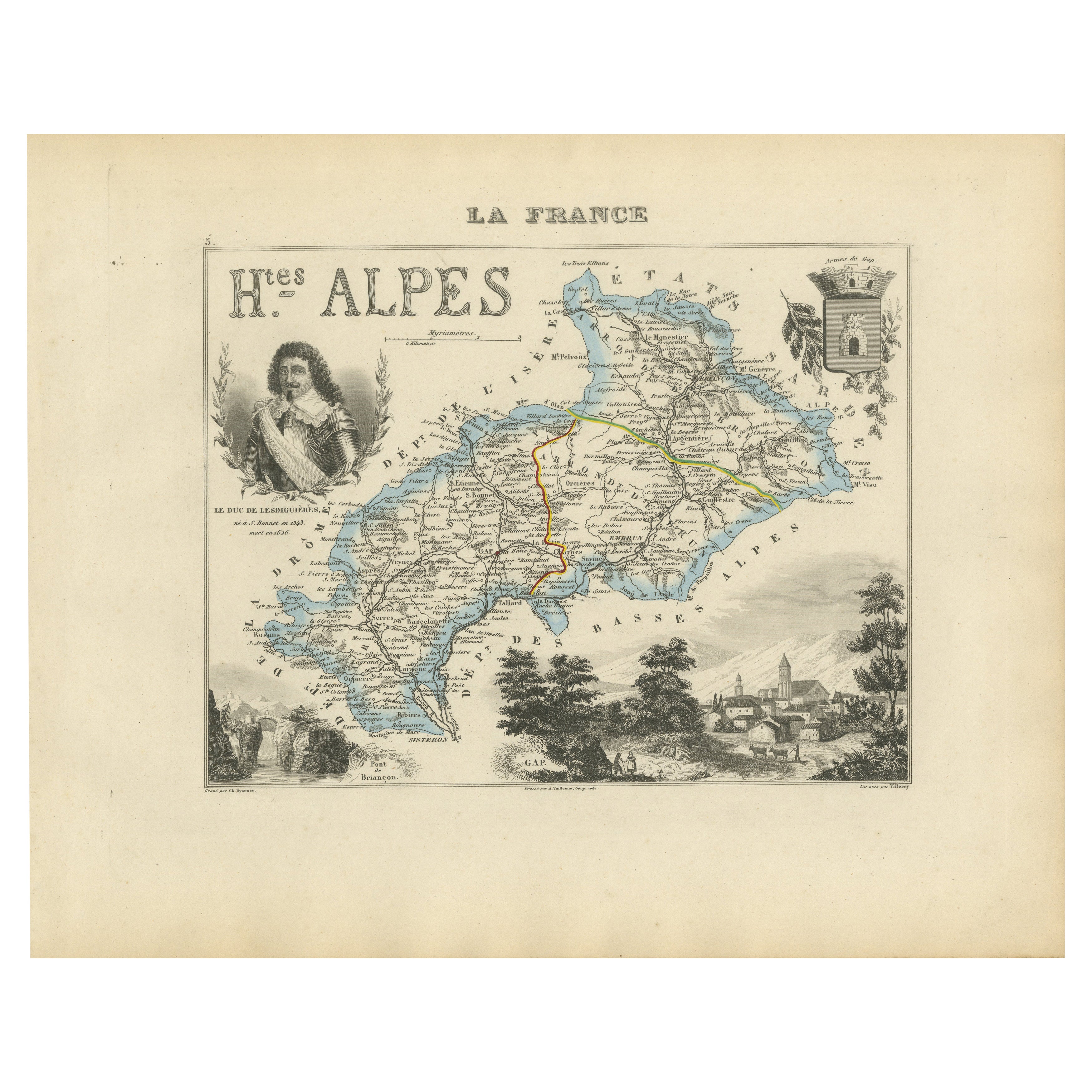
Alle anzeigenMap of Hautes-Alpes France with Gap and Alpine Scenery by Vuillemin, c.1850
Map of Hautes-Alpes France with Gap and Alpine Scenery by Vuillemin
Description:
This elegant 19th-century map of the Hautes-Alpes department in southeastern France was created by A...
Kategorie
Antik, Mittleres 19. Jahrhundert, Französisch, Landkarten
Materialien
Papier

Map of Ain France with Vineyards of Bugey and Notable Portraits, c.1850
Map of Ain France with Portraits of Bichat and Joubert by Vuillemin, 19th c
This highly decorative 19th-century map of the French department of Ain is taken from the celebrated Nouv...
Kategorie
Antik, Mittleres 19. Jahrhundert, Französisch, Landkarten
Materialien
Papier

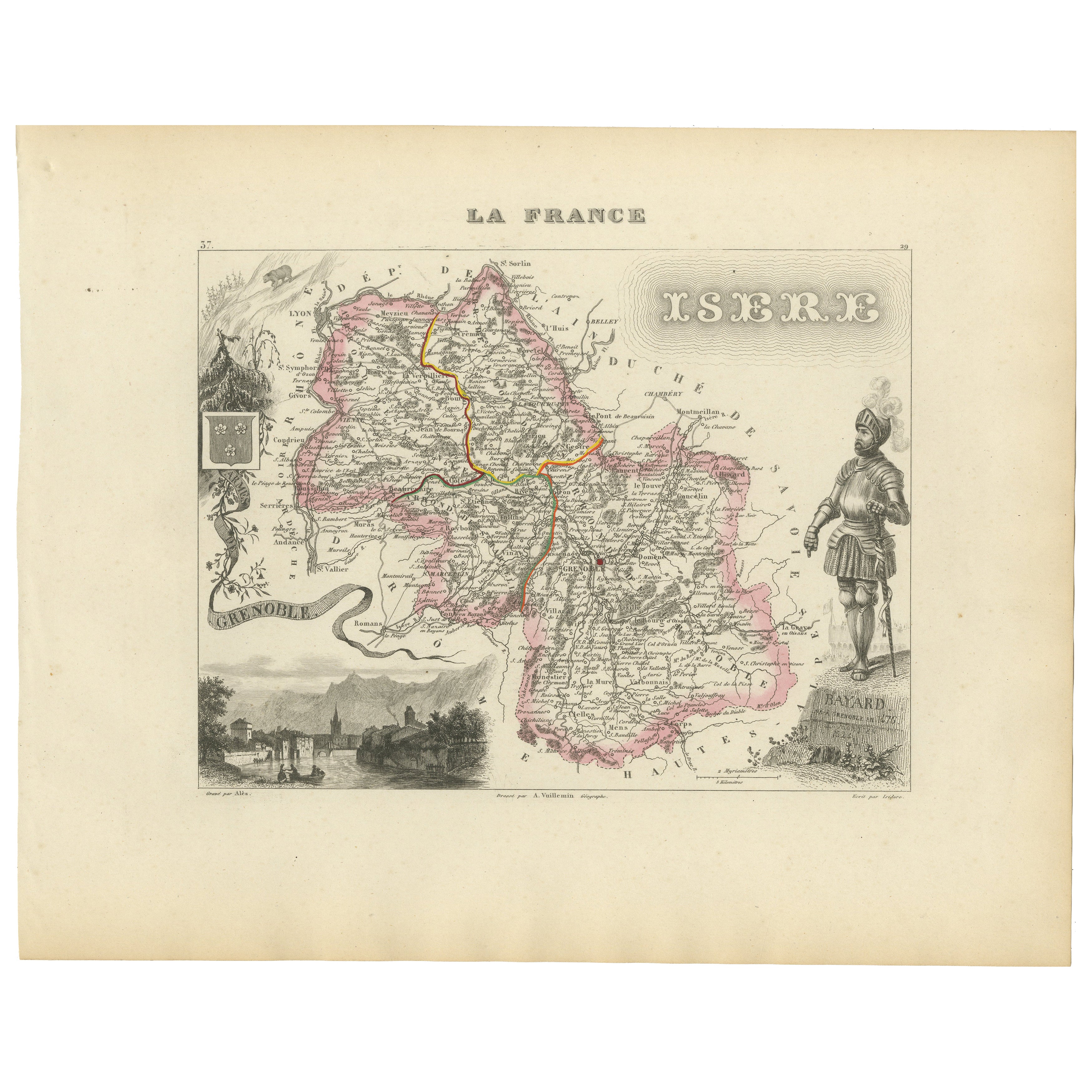
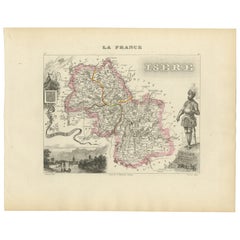
Antique French Map of Isère Region with Grenoble, Vienne, Dauphiné, 1800s
Antique Map of Isère, France by Vuillemin, 19th Century
This decorative 19th-century map presents the département of Isère in southeastern France, engraved by Alexandre Vuillemin. C...
Kategorie
Antik, Mittleres 19. Jahrhundert, Französisch, Landkarten
Materialien
Papier
Antike Karte von Basses-Alpes 'Frankreich' von V. Levasseur, 1854
Von Victor Levasseur
Antike Karte mit dem Titel 'Dépt. des Basses-Alpes'. Karte des französischen Departements Basses-Alpes, Frankreich. Das Ganze ist von aufwendigen dekorativen Gravuren umgeben, die so...
Kategorie
Antik, Mittleres 19. Jahrhundert, Landkarten
Materialien
Papier
160 € Angebotspreis
20 % Rabatt
Map of Allier France with Saint-Pourçain Wine Region by Vuillemin, 19th c
Map of Allier France with Saint-Pourçain Wine Region by Vuillemin, 19th c
This decorative 19th-century map of Allier, a central department of France, comes from the celebrated Nouve...
Kategorie
Antik, Mittleres 19. Jahrhundert, Französisch, Landkarten
Materialien
Papier

Handkolorierte antike Karte des Departements Basses-Alpes, Frankreich
Von Victor Levasseur
Antike Karte mit dem Titel 'Dépt. de l'Aube'. Karte des französischen Departements Basses-Alpes, Frankreich. Das Ganze ist von aufwendigen dekorativen Gravuren umgeben, die sowohl di...
Kategorie
Antik, Mittleres 19. Jahrhundert, Landkarten
Materialien
Papier
272 € Angebotspreis
20 % Rabatt
Das könnte Ihnen auch gefallen
Hautes Alpes, Frankreich. Antike Karte einer französischen Abteilung, 1856
Von Victor Levasseur
dept. des Hautes Alpes", Stahlstich mit originaler Handkolorierung der Umrisse, 1856, aus dem "Atlas National Illustre" von Levasseur.
Dieses Gebiet Frankreichs ist bekannt für die...
Kategorie
19. Jahrhundert, Naturalismus, Landschaftsdrucke
Materialien
Gravur

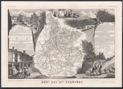
Hautes Pyreneen, Frankreich. Antike Karte einer französischen Abteilung, 1856
Von Victor Levasseur
dept. des Hautes Pyrenees", Stahlstich mit Originalumriss von Hand koloriert, 1856, aus Levasseurs Atlas National Illustre.
In diesem Gebiet befindet sich das Weinanbaugebiet Madir...
Kategorie
19. Jahrhundert, Naturalismus, Landschaftsdrucke
Materialien
Gravur
Pyrenees Orientales, Frankreich. Antike Karte einer französischen Abteilung, 1856
Von Victor Levasseur
dept. des Pyrenees Orientales", Stahlstich mit originaler Handkolorierung der Umrisse, 1856, aus dem "Atlas National Illustre" von Levasseur.
Dieses Gebiet ist ein bekanntes Weinan...
Kategorie
19. Jahrhundert, Naturalismus, Landschaftsdrucke
Materialien
Gravur

Hautes-Pyrnes-Karte – Originallithographie – 19. Jahrhundert
Die Karte der Hautes-Pyrénées ist eine Original-Lithographie eines anonymen Graveurs aus dem 19. Jahrhundert.
Gedruckt in Serien von "France Pittoresque" oben in der Mitte.
Der Erh...
Kategorie
19. Jahrhundert, Moderne, Figurative Drucke
Materialien
Papier, Lithografie

Antike antike 1856 Hand-Aquarellkarte des Obersts der Hautes Alpes von Levasseur's
Wir freuen uns, diese wunderschöne Aquarellkarte der österreichischen Alpen von 1856 mit dem Titel "Dept Des Hautes Alpes" aus dem Atlas National Illustre von Victor Levasseur zum Ve...
Kategorie
Antik, 1850er, Französisch, Frühviktorianisch, Landkarten
Materialien
Papier

Lozere, Frankreich. Antike Karte einer französischen Abteilung, 1856
Von Victor Levasseur
dept. de La Lozere", Stahlstich mit originaler Handkolorierung der Umrisse, 1856, aus dem "Atlas National Illustre" von Levasseur.
Dieser abgelegene, gebirgige Teil des Languedoc i...
Kategorie
19. Jahrhundert, Naturalismus, Landschaftsdrucke
Materialien
Gravur
