Objekte ähnlich wie Map of Calvados France with Caen and Cider-Brandy Region, 19th Century


Möchten Sie mehr Bilder oder Videos?
Zusätzliche Bilder oder Videos von dem*der Anbieter*in anfordern
1 von 10
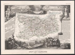
Map of Calvados France with Caen and Cider-Brandy Region, 19th Century
120 €Einschließlich MwSt.
Angaben zum Objekt
Map of Calvados France with Caen and Cider-Brandy Region, 19th Century
Description:
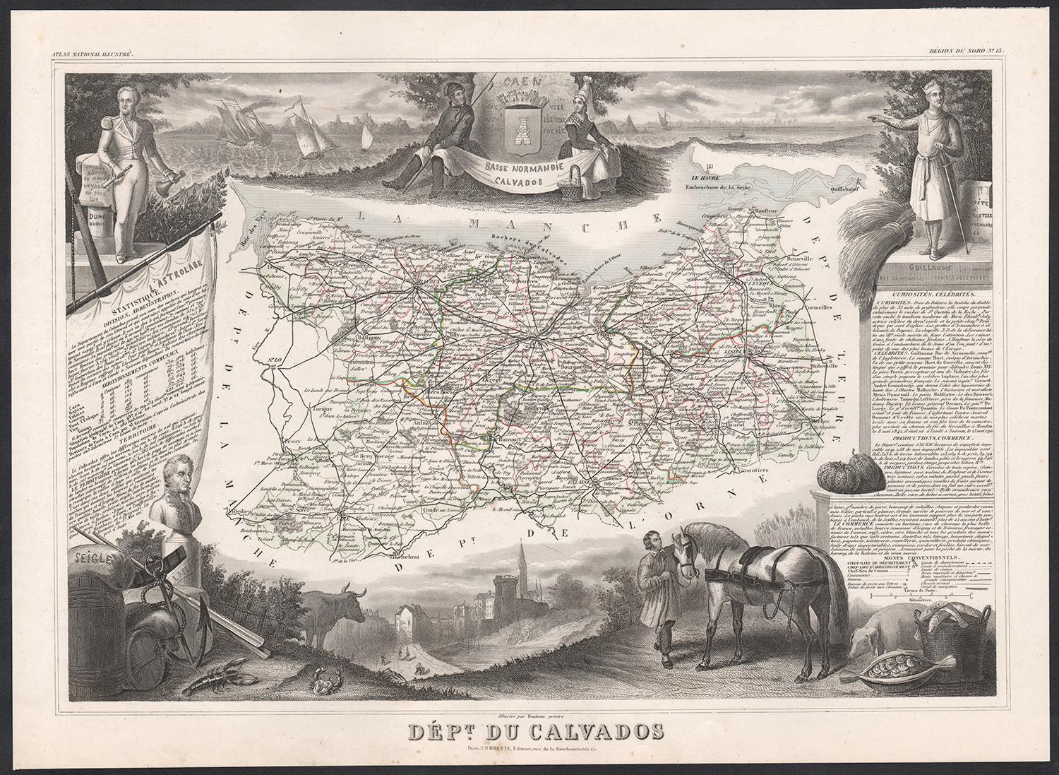
This finely engraved 19th-century map of the Calvados department in Normandy, northwestern France, comes from the *Nouvel Atlas Illustré* published in Paris by Migeon. The map was drawn by Alexandre Vuillemin and features a rich combination of precise geography and elegant embellishments, reflecting the historical and agricultural importance of this coastal region.
The map outlines Calvados in soft pink hand-coloring, highlighting towns, rivers, and roads, with the English Channel (La Manche) bordering the north. Caen, the department's capital and a cultural center since medieval times, is prominently positioned. The cartographic detailing includes the famed Norman countryside and coast, which played a vital role in French history and later in World War II.
In the lower left is a portrait of Dumont d’Urville, the explorer and naval officer born in Condé-sur-Noireau in Calvados. He is shown with nautical instruments, referencing his significant contributions to French exploration and science. In the lower right is a finely rendered view of the city of Caen, with its imposing Gothic architecture, likely representing the Church of Saint-Pierre or the Abbey of Saint-Étienne founded by William the Conqueror.
Calvados is perhaps best known for its namesake apple brandy, produced in the rolling orchards that stretch across the region. The department lies at the heart of the Calvados AOC, where cider apples are grown and distilled into one of France’s most iconic spirits. Alongside Calvados brandy, the region also produces fine cider, pommeau, and a range of cheeses, most notably Pont-l'Évêque and Livarot. These agricultural products have earned Calvados a reputation for rustic elegance and culinary depth.
This map captures the spirit of Normandy's maritime heritage, its agricultural landscape, and its intellectual legacy, making it ideal for collectors of historic French regions or food and wine enthusiasts.
Condition summary:
Very good condition with some light toning and minor foxing to the margins. The engraved detail is crisp, and the original hand coloring is well preserved.
Framing tips:
A rustic oak or walnut frame would match the map’s Norman character. A soft ivory or light grey mat will highlight the pink border color and the engraved vignette of Caen. Use museum-quality glass to protect and enhance the print for display.
- Maße:Höhe: 26,1 cm (10,28 in)Breite: 32,5 cm (12,8 in)Tiefe: 0,2 mm (0,01 in)
- Materialien und Methoden:Papier,Graviert
- Herkunftsort:
- Zeitalter:
- Herstellungsjahr:circa 1850
- Zustand:Very good condition with some light toning and minor foxing to the margins. The engraved detail is crisp, and the original hand coloring is well preserved.
- Anbieterstandort:Langweer, NL
- Referenznummer:Anbieter*in: BG-13331-131stDibs: LU3054345359802
Anbieterinformationen
5,0
Anerkannte Anbieter*innen
Diese renommierten Anbieter*innen sind führend in der Branche und repräsentieren die höchste Klasse in Sachen Qualität und Design.
Platin-Anbieter*in
Premium-Anbieter*innen mit einer Bewertung über 4,7 und 24 Stunden Reaktionszeit
Gründungsjahr 2009
1stDibs-Anbieter*in seit 2017
2.589 Verkäufe auf 1stDibs
Typische Antwortzeit: <1 Stunde
- VersandAngebot wird abgerufen …Versand von: Langweer, Niederlande
- Rückgabebedingungen
Einige Inhalte dieser Seite wurden automatisch übersetzt. Daher kann 1stDibs nicht die Richtigkeit der Übersetzungen garantieren. Englisch ist die Standardsprache dieser Website.
Authentizitätsgarantie
Im unwahrscheinlichen Fall eines Problems mit der Echtheit eines Objekts kontaktieren Sie uns bitte innerhalb von 1 Jahr für eine volle Rückerstattung. DetailsGeld-Zurück-Garantie
Wenn Ihr Objekt nicht der Beschreibung entspricht, beim Transport beschädigt wurde oder nicht ankommt, kontaktieren Sie uns bitte innerhalb von 7 Tagen für eine vollständige Rückerstattung. DetailsStornierung innerhalb von 24 Stunden
Sie können Ihren Kauf jederzeit innerhalb von 24 Stunden stornieren, ohne jegliche Gründe dafür angeben zu müssen.Geprüfte Anbieter*innen
Unsere Anbieter*innen unterliegen strengen Dienstleistungs- und Qualitätsstandards, wodurch wir die Seriosität unserer Angebote gewährleisten können.Preisgarantie
Wenn Sie feststellen, dass ein*e Anbieter*in dasselbe Objekt anderswo zu einem niedrigeren Preis anbietet, werden wir den Preis entsprechend anpassen.Zuverlässige weltweite Lieferung
Unsere erstklassigen Versandunternehmen bieten spezielle Versandoptionen weltweit, einschließlich individueller Lieferung.Mehr von diesem*dieser Anbieter*in
Alle anzeigenMap of Allier France with Saint-Pourçain Wine Region by Vuillemin, 19th c
Map of Allier France with Saint-Pourçain Wine Region by Vuillemin, 19th c
This decorative 19th-century map of Allier, a central department of France, comes from the celebrated Nouve...
Kategorie
Antik, Mittleres 19. Jahrhundert, Französisch, Landkarten
Materialien
Papier

Map of Côtes-du-Nord France with Saint-Brieuc and Brittany Coastline, c.1850
Map of Côtes-du-Nord France with Saint-Brieuc and Brittany Coastline, 19th c
Description:
This elegant 19th-century map of Côtes-du-Nord, the historic name for what is now known as ...
Kategorie
Antik, Mittleres 19. Jahrhundert, Französisch, Landkarten
Materialien
Papier

Map of Côte-d'Or France with Dijon and Burgundy Wine Region, 19th Century
Map of Côte-d'Or France with Dijon and Burgundy Wine Region, 19th Century
Description:
This beautifully engraved 19th-century map of Côte-d'Or, located in the historic region of Bur...
Kategorie
Antik, Mittleres 19. Jahrhundert, Französisch, Landkarten
Materialien
Papier

Antike Karte von Calvados 'Frankreich' von V. Levasseur, 1854
Von Victor Levasseur
Antike Karte mit dem Titel 'Dépt. du Calvados'. Karte des französischen Departements Calvados, Frankreich. Diese Region Frankreichs ist bekannt für die Herstellung von Calvados, dem ...
Kategorie
Antik, Mittleres 19. Jahrhundert, Landkarten
Materialien
Papier
160 € Angebotspreis
20 % Rabatt
Map of Aude France with Carcassonne and Languedoc Vineyards, 19th Century
Map of Aude France with Carcassonne and Languedoc Vineyards, 19th Century
Description:
This elegant 19th-century map of Aude, a department in southern France along the Mediterranean...
Kategorie
Antik, Mittleres 19. Jahrhundert, Französisch, Landkarten
Materialien
Papier

Antike Karte von Calais „Frankreich“ von V. Levasseur, 1854
Von Victor Levasseur
Antike Karte mit dem Titel 'Dépt. du Pas de Calais'. Karte des französischen Departements Calais, Frankreich. Dieses Gebiet ist bekannt für die Herstellung von Maroilles, einem Weich...
Kategorie
Antik, Mittleres 19. Jahrhundert, Landkarten
Materialien
Papier
144 € Angebotspreis
20 % Rabatt
Das könnte Ihnen auch gefallen
Calvados, Frankreich. Antike Karte einer französischen Abteilung, 1856
Von Victor Levasseur
Dept. du Calvados", Stahlstich mit originaler Handkolorierung der Umrisse, 1856, aus Levasseurs "Atlas National Illustre".
Diese Region Frankreichs ist bekannt für die Herstellung ...
Kategorie
19. Jahrhundert, Naturalismus, Landschaftsdrucke
Materialien
Gravur
Große Karte von Frankreich aus dem 19.
Große Karte von Frankreich aus dem 19. Jahrhundert.
Bemerkenswerter Zustand, mit einer angenehmen altersbedingten Patina.
Kürzlich gerahmt.
Frankreich CIRCA 1874.
Kategorie
Antik, Spätes 19. Jahrhundert, Französisch, Landkarten
Materialien
Leinen, Papier

CIRCA 1950 Original-Plakat von Calvados, entworfen von André Lesot - Normandie
Dieses Original-Plakat von Calvados aus dem Jahr 1950, entworfen von André Lesot, ist eine wunderbar detaillierte Darstellung dieser historischen Region in der Normandie, Frankreich....
Kategorie
1950er, Druckgrafiken und Multiples
Materialien
Lithografie, Papier, Leinen
Aude, Frankreich. Antike Karte einer französischen Abteilung, 1856
Von Victor Levasseur
dept. de L' Aude", Stahlstich mit Originalumriss von Hand koloriert, 1856, aus Levasseurs "Atlas National Illustre".
Diese Region Frankreichs ist berühmt für ihre große Vielfalt an...
Kategorie
19. Jahrhundert, Naturalismus, Landschaftsdrucke
Materialien
Gravur

Var, Frankreich. Antike Karte einer französischen Abteilung, 1856
Von Victor Levasseur
dept. du Var", Stahlstich mit handkolorierten Originalumrissen, 1856, aus dem Atlas National Illustre von Levasseur.
Var liegt im Herzen der Côte d'Azur und umfasst unter anderem d...
Kategorie
19. Jahrhundert, Naturalismus, Landschaftsdrucke
Materialien
Gravur

Frankreich, Nordteil. Antike Atlas-Karte des Jahrhunderts
Der Jahrhundertatlas. Frankreich, Nordteil'.
Originale antike Karte, 1903.
Insetkarten von "Frankreich in den Provinzen" und "Paris und Umgebung".
Zentrale Falte wie ausgestellt. N...
Kategorie
Frühes 20. Jahrhundert, Viktorianisch, Mehr Drucke
Materialien
Lithografie
