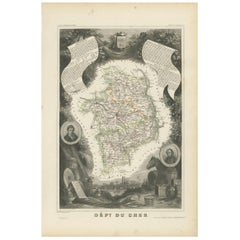
Objekte ähnlich wie Map of Cher France with Bourges, Sancerre Vineyards and Engraved Vignettes, 1850


Möchten Sie mehr Bilder oder Videos?
Zusätzliche Bilder oder Videos von dem*der Anbieter*in anfordern
1 von 10
Map of Cher France with Bourges, Sancerre Vineyards and Engraved Vignettes, 1850
120 €Einschließlich MwSt.
Angaben zum Objekt
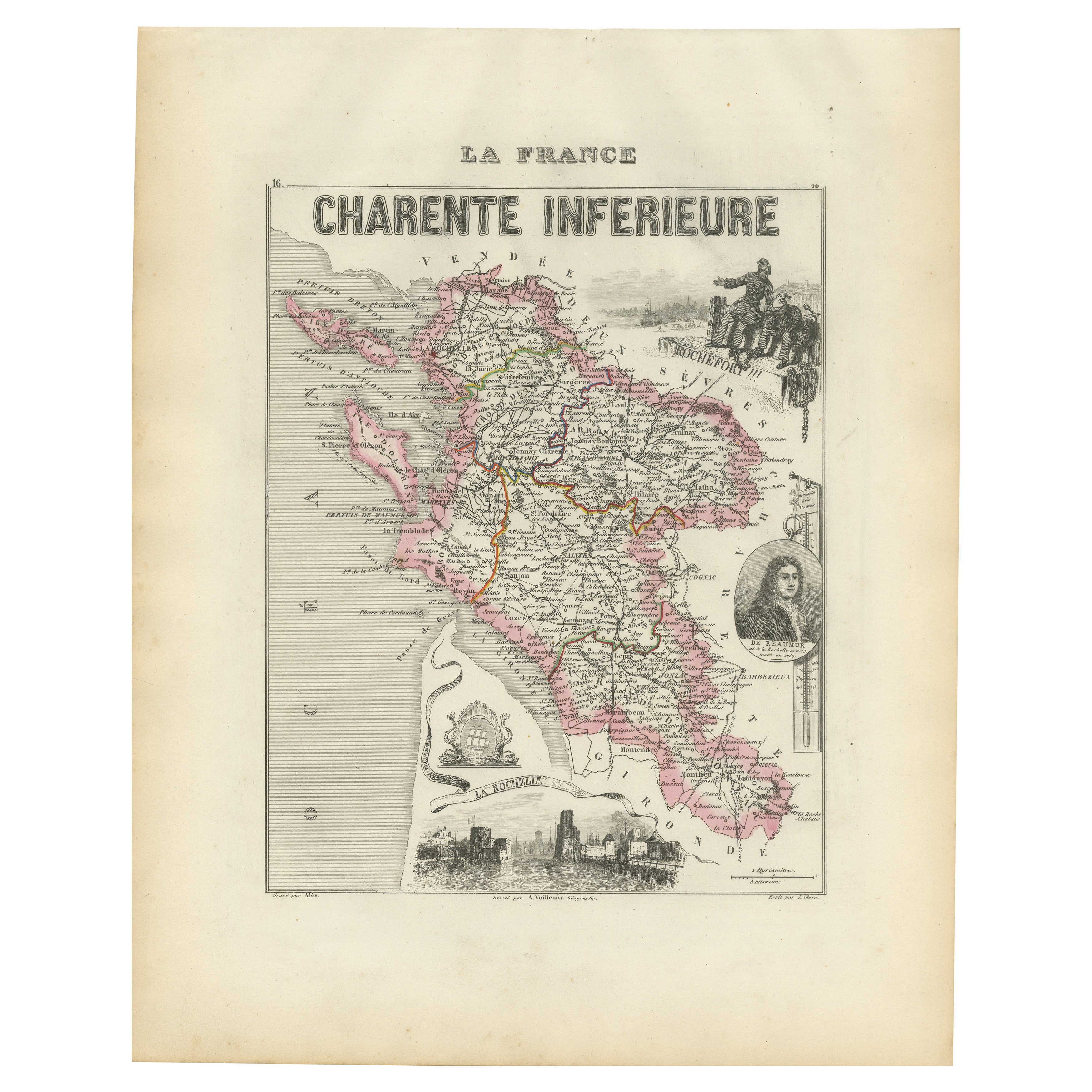
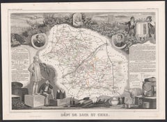
Map of Charente-Inférieure France with La Rochelle and Coastal Vineyards, 19th c
Description:
This decorative 19th-century map of the former department of Charente-Inférieure, now known as Charente-Maritime, was published in Paris by Migeon as part of the *Nouvel Atlas Illustré* and drawn by Alexandre Vuillemin. The map combines precise geographic rendering with visual storytelling, capturing the essence of France’s Atlantic coast during the mid-1800s.
Hand-colored in soft pink along the departmental borders, the map includes all major towns and transport routes, with La Rochelle and Rochefort prominently featured. The Atlantic coastline, river systems, and offshore islands such as Île de Ré and Île d’Oléron are clearly indicated. These elements emphasize the maritime identity of the region, historically shaped by naval, commercial, and fishing activity.
In the lower portion of the sheet is an engraved view of the fortified port city of La Rochelle, its harbor marked by towers and stone quays. At the top right, dockworkers are shown with a large anchor and chains, illustrating Rochefort’s role as an important naval base and shipyard during the Ancien Régime and Napoleonic era. On the right side is a portrait of de Ratzau, likely referring to the marquis who played a role in 17th-century military affairs in the region.
Charente-Maritime is also known for its viticulture, particularly its contribution to the Cognac region. Vineyards near Saintes and Jonzac form part of the outer areas of Cognac production. Additionally, the region is famous for its Pineau des Charentes, a sweet fortified wine blending grape must and Cognac. These coastal vineyards thrive in a maritime climate, producing grapes with distinctive character.
Beyond wine, the region is also celebrated for salt marshes, oysters from Marennes-Oléron, and a strong seafaring heritage. This map is an elegant tribute to a historically rich region whose legacy blends land, sea, and cultural depth.
Condition summary:
Very good antique condition. Light age toning and minor scattered foxing, mostly near the margins. Engraved lines are clear and the original hand coloring is well preserved.
Framing tips:
Pair this map with a light wood or brushed silver frame to echo the maritime setting. Use a pale blue or cream mat to complement the coastal theme and pastel borders. UV-protective glass is recommended for display and preservation.
- Maße:Höhe: 32,5 cm (12,8 in)Breite: 26,1 cm (10,28 in)Tiefe: 0,2 mm (0,01 in)
- Materialien und Methoden:Papier,Graviert
- Herkunftsort:
- Zeitalter:
- Herstellungsjahr:circa 1850
- Zustand:Very good antique condition. Light age toning and minor scattered foxing, mostly near the margins. Engraved lines are clear and the original hand coloring is well preserved.
- Anbieterstandort:Langweer, NL
- Referenznummer:Anbieter*in: BG-13331-171stDibs: LU3054345363582
Anbieterinformationen
5,0
Anerkannte Anbieter*innen
Diese renommierten Anbieter*innen sind führend in der Branche und repräsentieren die höchste Klasse in Sachen Qualität und Design.
Platin-Anbieter*in
Premium-Anbieter*innen mit einer Bewertung über 4,7 und 24 Stunden Reaktionszeit
Gründungsjahr 2009
1stDibs-Anbieter*in seit 2017
2.609 Verkäufe auf 1stDibs
Typische Antwortzeit: <1 Stunde
- VersandAngebot wird abgerufen …Versand von: Langweer, Niederlande
- Rückgabebedingungen
Einige Inhalte dieser Seite wurden automatisch übersetzt. Daher kann 1stDibs nicht die Richtigkeit der Übersetzungen garantieren. Englisch ist die Standardsprache dieser Website.
Authentizitätsgarantie
Im unwahrscheinlichen Fall eines Problems mit der Echtheit eines Objekts kontaktieren Sie uns bitte innerhalb von 1 Jahr für eine volle Rückerstattung. DetailsGeld-Zurück-Garantie
Wenn Ihr Objekt nicht der Beschreibung entspricht, beim Transport beschädigt wurde oder nicht ankommt, kontaktieren Sie uns bitte innerhalb von 7 Tagen für eine vollständige Rückerstattung. DetailsStornierung innerhalb von 24 Stunden
Sie können Ihren Kauf jederzeit innerhalb von 24 Stunden stornieren, ohne jegliche Gründe dafür angeben zu müssen.Geprüfte Anbieter*innen
Unsere Anbieter*innen unterliegen strengen Dienstleistungs- und Qualitätsstandards, wodurch wir die Seriosität unserer Angebote gewährleisten können.Preisgarantie
Wenn Sie feststellen, dass ein*e Anbieter*in dasselbe Objekt anderswo zu einem niedrigeren Preis anbietet, werden wir den Preis entsprechend anpassen.Zuverlässige weltweite Lieferung
Unsere erstklassigen Versandunternehmen bieten spezielle Versandoptionen weltweit, einschließlich individueller Lieferung.Mehr von diesem*dieser Anbieter*in
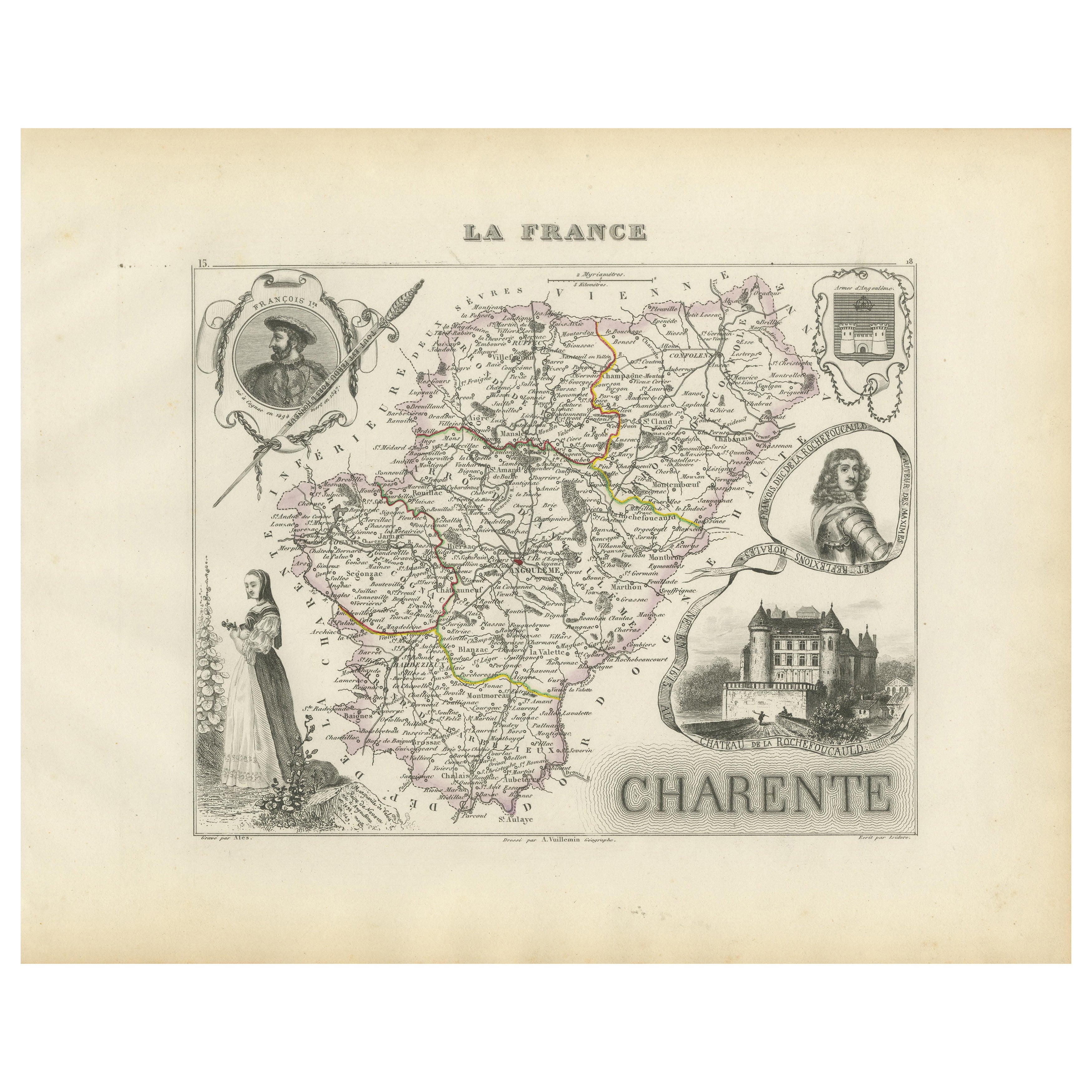
Alle anzeigenMap of Charente France with Cognac Region and Château de La Rochefoucauld, 1850
Map of Charente France with Cognac Region and Château de La Rochefoucauld, 19th c
Description:
This richly illustrated 19th-century map of the Charente department in southwestern Fr...
Kategorie
Antik, Mittleres 19. Jahrhundert, Französisch, Landkarten
Materialien
Papier

Map of Côtes-du-Nord France with Saint-Brieuc and Brittany Coastline, c.1850
Map of Côtes-du-Nord France with Saint-Brieuc and Brittany Coastline, 19th c
Description:
This elegant 19th-century map of Côtes-du-Nord, the historic name for what is now known as ...
Kategorie
Antik, Mittleres 19. Jahrhundert, Französisch, Landkarten
Materialien
Papier

Map of Allier France with Saint-Pourçain Wine Region by Vuillemin, 19th c
Map of Allier France with Saint-Pourçain Wine Region by Vuillemin, 19th c
This decorative 19th-century map of Allier, a central department of France, comes from the celebrated Nouve...
Kategorie
Antik, Mittleres 19. Jahrhundert, Französisch, Landkarten
Materialien
Papier

Map of Côte-d'Or France with Dijon and Burgundy Wine Region, 19th Century
Map of Côte-d'Or France with Dijon and Burgundy Wine Region, 19th Century
Description:
This beautifully engraved 19th-century map of Côte-d'Or, located in the historic region of Bur...
Kategorie
Antik, Mittleres 19. Jahrhundert, Französisch, Landkarten
Materialien
Papier

Map of Charente-Inférieure France with La Rochelle and Coastal Vineyards, c.1850
Map of Charente-Inférieure France with La Rochelle and Coastal Vineyards, 19th c
Description:
This decorative 19th-century map of the former department of Charente-Inférieure, now k...
Kategorie
Antik, Mittleres 19. Jahrhundert, Französisch, Landkarten
Materialien
Papier
Antike Cher-Karte In Frankreich, 1854
Von Victor Levasseur
Antike Karte mit dem Titel 'Dépt. des Bses. Pyrenäen". Karte des französischen Departements Basses Pyrenees, Frankreich. Zu diesem Departement gehört die Weinregion Jurancon, die für...
Kategorie
Antik, Mittleres 19. Jahrhundert, Landkarten
Materialien
Papier
144 € Angebotspreis
20 % Rabatt
Das könnte Ihnen auch gefallen
Loir und Cher, Frankreich. Antike Karte einer französischen Abteilung, 1856
Von Victor Levasseur
dept. de Loir et Cher", Stahlstich mit originaler Handkolorierung der Umrisse, 1856, aus dem Atlas National Illustre von Levasseur.
Dieses Gebiet ist vor allem für die Herstellung ...
Kategorie
19. Jahrhundert, Naturalismus, Landschaftsdrucke
Materialien
Gravur
Beinahe Frankreich. Antike Karte einer französischen Abteilung, 1856
Von Victor Levasseur
dept. de L'Aube", Stahlstich mit originaler Handkolorierung der Umrisse, 1856, aus dem "Atlas National Illustre" von Levasseur.
Diese Region Frankreichs ist bekannt für die Herstel...
Kategorie
19. Jahrhundert, Naturalismus, Landschaftsdrucke
Materialien
Gravur

L'Isere, Frankreich. Antike Karte der französischen Abteilung, 1856
Von Victor Levasseur
dept. de L'Isere", Stahlstich mit Originalumriss von Hand koloriert, 1856, aus Levasseurs "Atlas National Illustre".
Dieses Gebiet ist bekannt für die Herstellung von Bleu du Verco...
Kategorie
19. Jahrhundert, Naturalismus, Landschaftsdrucke
Materialien
Gravur

Indre und Loire, Frankreich. Antike Karte einer französischen Abteilung, 1856
Von Victor Levasseur
dept. d'Indre et Loire", Stahlstich mit Originalumriss von Hand koloriert, 1856, aus Levasseurs "Atlas National Illustre".
Dieses Gebiet ist bekannt für die Herstellung von Chenin ...
Kategorie
19. Jahrhundert, Naturalismus, Landschaftsdrucke
Materialien
Gravur

Lozere, Frankreich. Antike Karte einer französischen Abteilung, 1856
Von Victor Levasseur
dept. de La Lozere", Stahlstich mit originaler Handkolorierung der Umrisse, 1856, aus dem "Atlas National Illustre" von Levasseur.
Dieser abgelegene, gebirgige Teil des Languedoc i...
Kategorie
19. Jahrhundert, Naturalismus, Landschaftsdrucke
Materialien
Gravur

Aude, Frankreich. Antike Karte einer französischen Abteilung, 1856
Von Victor Levasseur
dept. de L' Aude", Stahlstich mit Originalumriss von Hand koloriert, 1856, aus Levasseurs "Atlas National Illustre".
Diese Region Frankreichs ist berühmt für ihre große Vielfalt an...
Kategorie
19. Jahrhundert, Naturalismus, Landschaftsdrucke
Materialien
Gravur
