Objekte ähnlich wie Map of Gard France with Pont du Gard and Wine Regions by Vuillemin, 19th c


Möchten Sie mehr Bilder oder Videos?
Zusätzliche Bilder oder Videos von dem*der Anbieter*in anfordern
1 von 10
Map of Gard France with Pont du Gard and Wine Regions by Vuillemin, 19th c
140 €Einschließlich MwSt.
Angaben zum Objekt
Title: Map of Gard France with Pont du Gard and Wine Regions by Vuillemin, 19th c
Description:
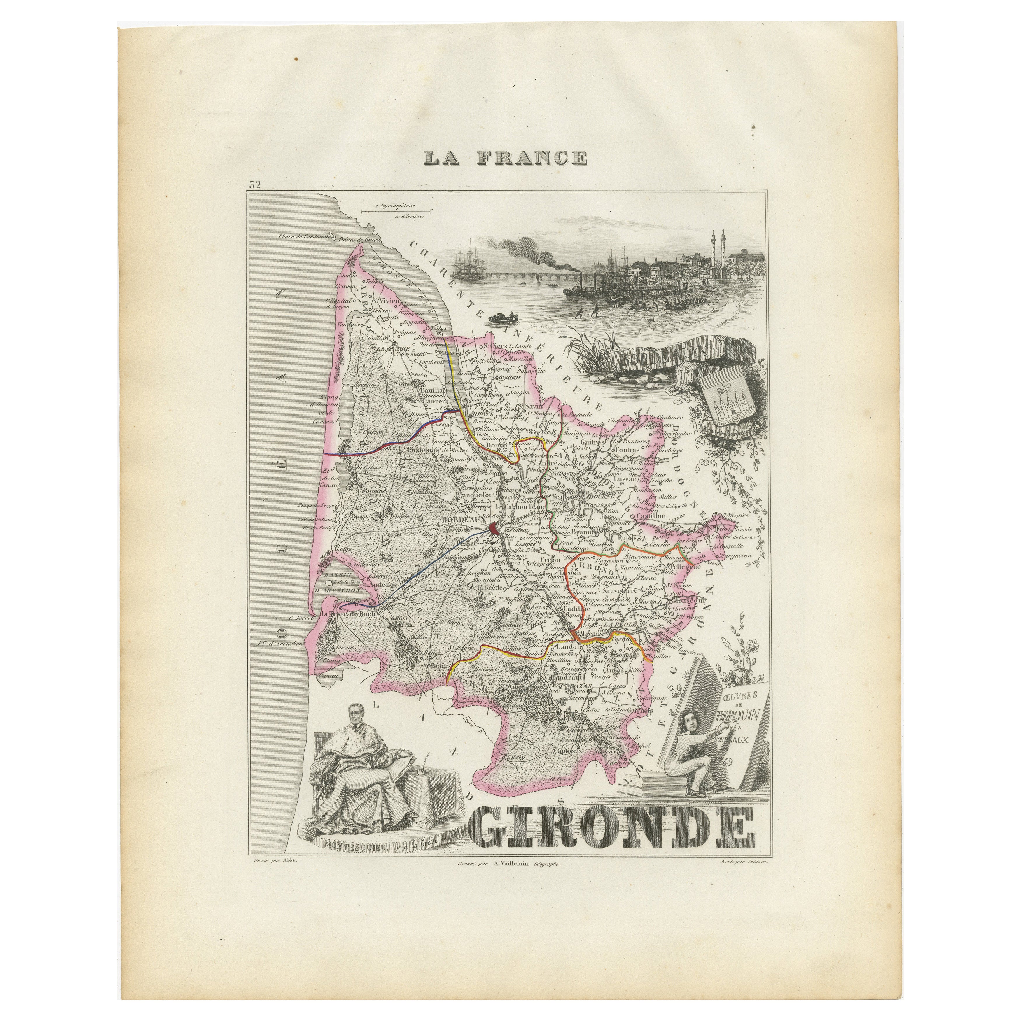
This finely engraved 19th-century map of the department of Gard in southern France was produced by Alexandre Vuillemin and published by Migeon in Paris as part of the *Nouvel Atlas Illustré*. The map blends detailed topographical information with artistic embellishments, offering a window into the geography, culture, and heritage of the region.
Gard is located in the Occitanie region and borders the Mediterranean Sea, Ardèche, Hérault, Bouches-du-Rhône, and Lozère. The map outlines the department with a fine hand-colored orange border and clearly marks towns, rivers, roadways, and topographic features. Nîmes, Uzès, Alès, and Beaucaire are among the many towns shown in detail.
At the lower left, a beautifully rendered vignette features the iconic **Pont du Gard**, a Roman aqueduct that stands as one of the most impressive and well-preserved Roman engineering feats in France. Built in the first century AD, it carried water to the city of Nîmes and remains a UNESCO World Heritage Site.
To the lower right, the map includes a portrait of **Jacques-Joseph de Gourbillon**, a local historical figure, with an unfurled map scroll and inscription. A coat of arms and botanical ornamentation add further decorative elements to the sheet.
Gard is also well known for its wine production, forming part of the greater **Côtes du Rhône** appellation. Vineyards near the Rhône River, including those around Tavel and Lirac, are especially notable. Tavel produces one of France’s most celebrated rosé wines, known for its full body, dry character, and historical reputation—it was said to be a favorite of Louis XIV and Ernest Hemingway. The department also produces reds and whites under the Costières de Nîmes and Duché d’Uzès AOCs, showcasing a blend of Mediterranean climate and Rhône varietals such as Syrah, Grenache, Mourvèdre, and Viognier.
Alexandre Vuillemin, a highly regarded French cartographer of the 19th century, was known for his clear yet decorative maps. His works with Migeon often included informative and picturesque features that made geography accessible and engaging to a broader audience.
Condition summary:
Very good condition with light age toning at the edges and a few minor foxing marks. The engraved detail remains sharp and the hand coloring is clean and well-preserved.
Framing tips:
Frame this map in a natural walnut or classic gold frame to enhance the historic charm. A warm ivory or pale terracotta mat will complement the orange border and Mediterranean tone of the subject. UV-protective glass is recommended for conservation.
- Maße:Höhe: 26,1 cm (10,28 in)Breite: 32,5 cm (12,8 in)Tiefe: 0,2 mm (0,01 in)
- Materialien und Methoden:Papier,Graviert
- Herkunftsort:
- Zeitalter:
- Herstellungsjahr:circa 1850
- Zustand:Very good condition with light age toning at the edges and a few minor foxing marks. The engraved detail remains sharp and the hand coloring is clean and well-preserved.
- Anbieterstandort:Langweer, NL
- Referenznummer:Anbieter*in: BG-13331-291stDibs: LU3054345363922
Anbieterinformationen
5,0
Anerkannte Anbieter*innen
Diese renommierten Anbieter*innen sind führend in der Branche und repräsentieren die höchste Klasse in Sachen Qualität und Design.
Platin-Anbieter*in
Premium-Anbieter*innen mit einer Bewertung über 4,7 und 24 Stunden Reaktionszeit
Gründungsjahr 2009
1stDibs-Anbieter*in seit 2017
2.655 Verkäufe auf 1stDibs
Typische Antwortzeit: <1 Stunde
- VersandAngebot wird abgerufen …Versand von: Langweer, Niederlande
- Rückgabebedingungen
Einige Inhalte dieser Seite wurden automatisch übersetzt. Daher kann 1stDibs nicht die Richtigkeit der Übersetzungen garantieren. Englisch ist die Standardsprache dieser Website.
Authentizitätsgarantie
Im unwahrscheinlichen Fall eines Problems mit der Echtheit eines Objekts kontaktieren Sie uns bitte innerhalb von 1 Jahr für eine volle Rückerstattung. DetailsGeld-Zurück-Garantie
Wenn Ihr Objekt nicht der Beschreibung entspricht, beim Transport beschädigt wurde oder nicht ankommt, kontaktieren Sie uns bitte innerhalb von 7 Tagen für eine vollständige Rückerstattung. DetailsStornierung innerhalb von 24 Stunden
Sie können Ihren Kauf jederzeit innerhalb von 24 Stunden stornieren, ohne jegliche Gründe dafür angeben zu müssen.Geprüfte Anbieter*innen
Unsere Anbieter*innen unterliegen strengen Dienstleistungs- und Qualitätsstandards, wodurch wir die Seriosität unserer Angebote gewährleisten können.Preisgarantie
Wenn Sie feststellen, dass ein*e Anbieter*in dasselbe Objekt anderswo zu einem niedrigeren Preis anbietet, werden wir den Preis entsprechend anpassen.Zuverlässige weltweite Lieferung
Unsere erstklassigen Versandunternehmen bieten spezielle Versandoptionen weltweit, einschließlich individueller Lieferung.Mehr von diesem*dieser Anbieter*in
Alle anzeigenMap of Allier France with Saint-Pourçain Wine Region by Vuillemin, 19th c
Map of Allier France with Saint-Pourçain Wine Region by Vuillemin, 19th c
This decorative 19th-century map of Allier, a central department of France, comes from the celebrated Nouve...
Kategorie
Antik, Mittleres 19. Jahrhundert, Französisch, Landkarten
Materialien
Papier

Karte von Gers Frankreich mit Auch und Armagnac Weinregion von Vuillemin, 19.
Karte von Gers Frankreich mit Auch und Armagnac Weinregion von Vuillemin, 19.
Diese gestochene und handkolorierte Karte des Departements Gers im Südwesten Frankreichs aus dem 19. Ja...
Kategorie
Antik, Mittleres 19. Jahrhundert, Französisch, Landkarten
Materialien
Papier

Map of Côtes-du-Nord France with Saint-Brieuc and Brittany Coastline, c.1850
Map of Côtes-du-Nord France with Saint-Brieuc and Brittany Coastline, 19th c
Description:
This elegant 19th-century map of Côtes-du-Nord, the historic name for what is now known as ...
Kategorie
Antik, Mittleres 19. Jahrhundert, Französisch, Landkarten
Materialien
Papier

Map of Ain France with Vineyards of Bugey and Notable Portraits, c.1850
Map of Ain France with Portraits of Bichat and Joubert by Vuillemin, 19th c
This highly decorative 19th-century map of the French department of Ain is taken from the celebrated Nouv...
Kategorie
Antik, Mittleres 19. Jahrhundert, Französisch, Landkarten
Materialien
Papier

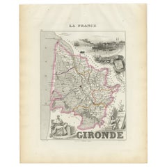
Karte von Gironde Frankreich mit der Weinregion Bordeaux von Vuillemin, 19.
Karte von Gironde Frankreich mit der Weinregion Bordeaux von Vuillemin, 19.
Diese eindrucksvolle Karte der Gironde, Frankreich, aus dem 19. Jahrhundert ist Teil des Nouvel Atlas Ill...
Kategorie
Antik, Mittleres 19. Jahrhundert, Französisch, Landkarten
Materialien
Papier
Map of Aisne France with Soissons and Champagne Vineyards by Vuillemin, 19th c
Map of Aisne France with Soissons and Champagne Vineyards by Vuillemin, 19th c
Description:
This richly detailed 19th-century engraved and hand-colored map of the department of Aisn...
Kategorie
Antik, Mittleres 19. Jahrhundert, Französisch, Landkarten
Materialien
Papier

Das könnte Ihnen auch gefallen
Große Karte von Frankreich aus dem 19.
Große Karte von Frankreich aus dem 19. Jahrhundert.
Bemerkenswerter Zustand, mit einer angenehmen altersbedingten Patina.
Kürzlich gerahmt.
Frankreich CIRCA 1874.
Kategorie
Antik, Spätes 19. Jahrhundert, Französisch, Landkarten
Materialien
Leinen, Papier

Var, Frankreich. Antike Karte einer französischen Abteilung, 1856
Von Victor Levasseur
dept. du Var", Stahlstich mit handkolorierten Originalumrissen, 1856, aus dem Atlas National Illustre von Levasseur.
Var liegt im Herzen der Côte d'Azur und umfasst unter anderem d...
Kategorie
19. Jahrhundert, Naturalismus, Landschaftsdrucke
Materialien
Gravur

Anlehnung an Loire und Loire, Frankreich. Antike Karte einer französischen Abteilung, 1856
Von Victor Levasseur
dept. de Saone et Loire", Stahlstich mit originaler Handkolorierung der Umrisse, 1856, aus: Atlas National Illustre von Levasseur.
Das französische Departement Saone et Loire ist d...
Kategorie
19. Jahrhundert, Naturalismus, Landschaftsdrucke
Materialien
Gravur

Aude, Frankreich. Antike Karte einer französischen Abteilung, 1856
Von Victor Levasseur
dept. de L' Aude", Stahlstich mit Originalumriss von Hand koloriert, 1856, aus Levasseurs "Atlas National Illustre".
Diese Region Frankreichs ist berühmt für ihre große Vielfalt an...
Kategorie
19. Jahrhundert, Naturalismus, Landschaftsdrucke
Materialien
Gravur

Frankreich, Nordteil. Antike Atlas-Karte des Jahrhunderts
Der Jahrhundertatlas. Frankreich, Nordteil'.
Originale antike Karte, 1903.
Insetkarten von "Frankreich in den Provinzen" und "Paris und Umgebung".
Zentrale Falte wie ausgestellt. N...
Kategorie
Frühes 20. Jahrhundert, Viktorianisch, Mehr Drucke
Materialien
Lithografie

Kartenkarte Frankreichs – Radierung – 1820
Karte von Frankreich ist eine Original-Radierung von einem unbekannten Künstler des 19. Jahrhunderts im Jahr 1820 realisiert.
Sehr guter Zustand auf zwei weißen Blättern, die in der...
Kategorie
1820er, Moderne, Figurative Drucke
Materialien
Radierung
