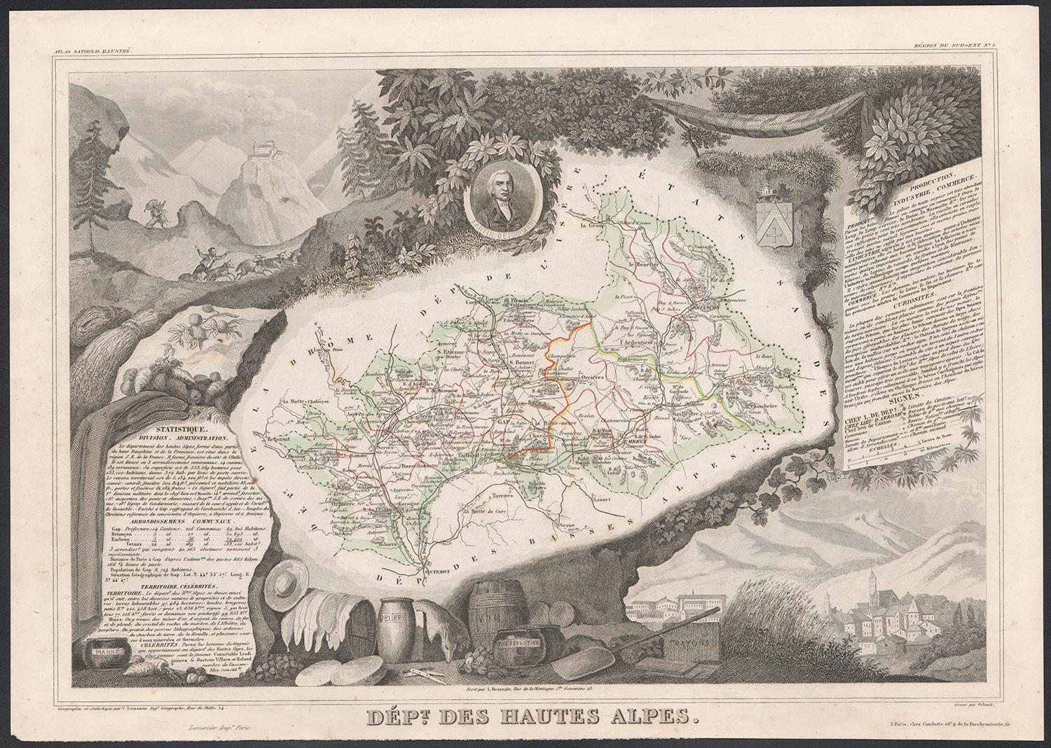
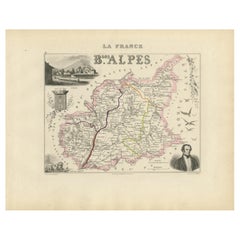
Objekte ähnlich wie Map of Hautes-Alpes France with Gap and Alpine Scenery by Vuillemin, c.1850

Möchten Sie mehr Bilder oder Videos?
Zusätzliche Bilder oder Videos von dem*der Anbieter*in anfordern
1 von 10
Map of Hautes-Alpes France with Gap and Alpine Scenery by Vuillemin, c.1850
120 €Einschließlich MwSt.
Angaben zum Objekt
Map of Hautes-Alpes France with Gap and Alpine Scenery by Vuillemin
Description:
This elegant 19th-century map of the Hautes-Alpes department in southeastern France was created by Alexandre Vuillemin and published by Migeon in Paris as part of the richly illustrated Nouvel Atlas Illustré. The map presents a detailed view of this mountainous region, framed by artistic engravings that highlight its historical, topographical, and cultural significance.
Hautes-Alpes is one of the highest and most sparsely populated departments in France, located in the heart of the French Alps. The map is bordered with a soft hand-colored blue to indicate the departmental boundary. Towns, roads, and rivers are carefully engraved, and the mountainous terrain is subtly rendered with engraved shading. The map offers a close view of the towns of Gap, Embrun, Briançon, and the surrounding alpine passes that have long connected France and Italy.
At the upper left, a portrait of the Duc de Lesdiguières is featured. He was a key military leader in the Wars of Religion and the last Constable of France, born in the region and associated with its defense and development. In the upper right, a coat of arms appears with a fortified tower motif. The lower half of the sheet is dominated by an engraved vignette of Gap, the department’s prefecture, nestled in an idyllic alpine valley. Trees, livestock, and cottages contribute to the rural and peaceful atmosphere that characterizes this high-altitude area.
Though Hautes-Alpes is not a major wine-producing region due to its elevation and climate, it is known for small-scale, high-altitude viticulture in valleys such as those around Embrun and Tallard. More than its wine, however, the area is celebrated for winter sports, mountain tourism, and its stunning natural scenery. Hiking, skiing, and nature excursions are key to the region’s identity.
Alexandre Vuillemin was known for his skill in producing maps that were both accurate and decorative. His publisher, Migeon, brought these works to a wide audience through visually engaging atlases, combining educational and artistic appeal.
Condition summary:
Very good antique condition with only minor age-related foxing in the margins. Original hand-coloring is well preserved, and all engraved lines remain crisp and clear.
Framing tips:
This map would suit a natural wood frame or one with a distressed alpine finish. A cream or pale blue mat will complement the hand-colored border and evoke the cool tones of the mountain setting. Museum-quality glass is recommended for protection.
- Maße:Höhe: 26,1 cm (10,28 in)Breite: 32,5 cm (12,8 in)Tiefe: 0,2 mm (0,01 in)
- Materialien und Methoden:Papier,Graviert
- Herkunftsort:
- Zeitalter:
- Herstellungsjahr:circa 1850
- Zustand:Very good antique condition with only minor age-related foxing in the margins. Original hand-coloring is well preserved, and all engraved lines remain crisp and clear.
- Anbieterstandort:Langweer, NL
- Referenznummer:Anbieter*in: BG-13331-51stDibs: LU3054345359152
Anbieterinformationen
5,0
Anerkannte Anbieter*innen
Diese renommierten Anbieter*innen sind führend in der Branche und repräsentieren die höchste Klasse in Sachen Qualität und Design.
Platin-Anbieter*in
Premium-Anbieter*innen mit einer Bewertung über 4,7 und 24 Stunden Reaktionszeit
Gründungsjahr 2009
1stDibs-Anbieter*in seit 2017
2.641 Verkäufe auf 1stDibs
Typische Antwortzeit: <1 Stunde
- VersandAngebot wird abgerufen …Versand von: Langweer, Niederlande
- Rückgabebedingungen
Einige Inhalte dieser Seite wurden automatisch übersetzt. Daher kann 1stDibs nicht die Richtigkeit der Übersetzungen garantieren. Englisch ist die Standardsprache dieser Website.
Authentizitätsgarantie
Im unwahrscheinlichen Fall eines Problems mit der Echtheit eines Objekts kontaktieren Sie uns bitte innerhalb von 1 Jahr für eine volle Rückerstattung. DetailsGeld-Zurück-Garantie
Wenn Ihr Objekt nicht der Beschreibung entspricht, beim Transport beschädigt wurde oder nicht ankommt, kontaktieren Sie uns bitte innerhalb von 7 Tagen für eine vollständige Rückerstattung. DetailsStornierung innerhalb von 24 Stunden
Sie können Ihren Kauf jederzeit innerhalb von 24 Stunden stornieren, ohne jegliche Gründe dafür angeben zu müssen.Geprüfte Anbieter*innen
Unsere Anbieter*innen unterliegen strengen Dienstleistungs- und Qualitätsstandards, wodurch wir die Seriosität unserer Angebote gewährleisten können.Preisgarantie
Wenn Sie feststellen, dass ein*e Anbieter*in dasselbe Objekt anderswo zu einem niedrigeren Preis anbietet, werden wir den Preis entsprechend anpassen.Zuverlässige weltweite Lieferung
Unsere erstklassigen Versandunternehmen bieten spezielle Versandoptionen weltweit, einschließlich individueller Lieferung.Mehr von diesem*dieser Anbieter*in
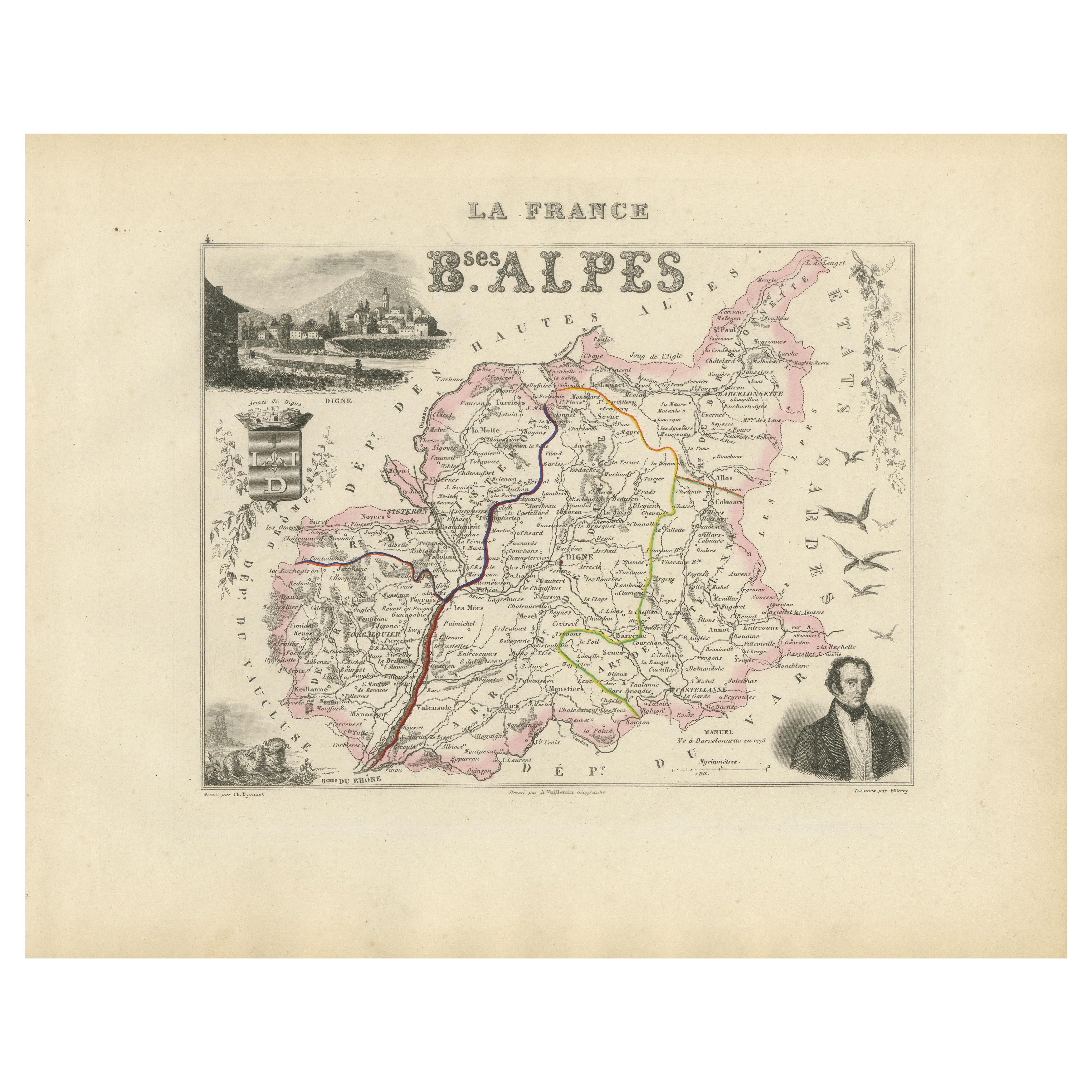
Alle anzeigenMap of Basses-Alpes France with Digne and Lavender Region by Vuillemin, c.1850
Map of Basses-Alpes France with Digne and Lavender Region by Vuillemin, 19th c
This finely engraved 19th-century map of the Basses-Alpes department of France (known today as Alpes-d...
Kategorie
Antik, Mittleres 19. Jahrhundert, Französisch, Landkarten
Materialien
Papier
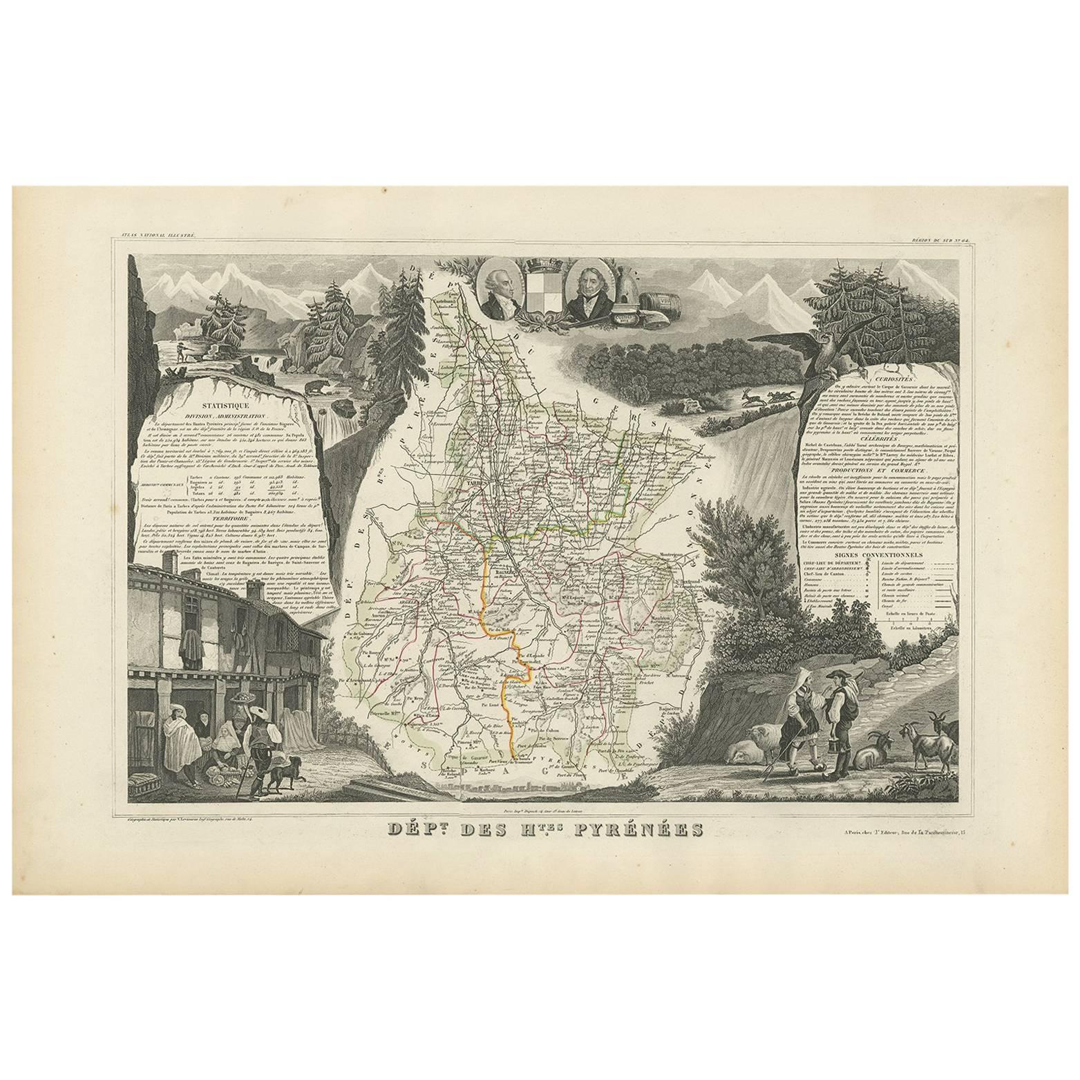
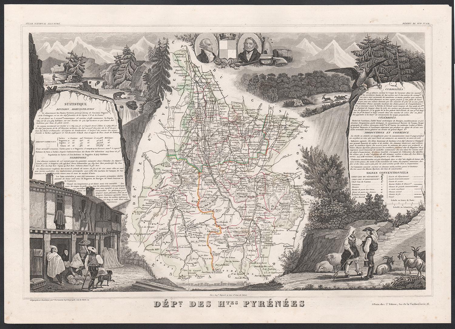
Antike Karte der Hautes Pyreneen „Frankreich“ von V. Levasseur, 1854
Von Victor Levasseur
Antike Karte mit dem Titel 'Dépt. des Htes. Pyrenäen". Karte des französischen Departements Hautes Pyrenees, Frankreich. In diesem Gebiet befindet sich das Weinanbaugebiet Madiran. M...
Kategorie
Antik, Mittleres 19. Jahrhundert, Landkarten
Materialien
Papier
160 € Angebotspreis
20 % Rabatt
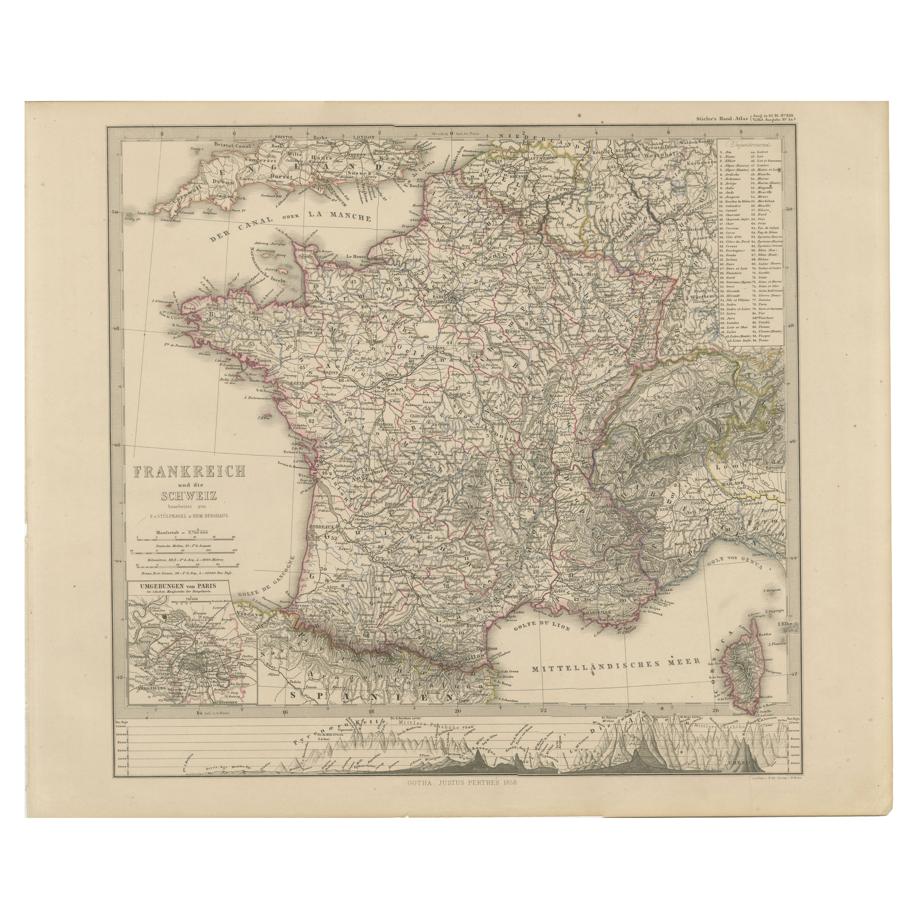
1856 Frankreich und Schweiz Karte mit Gebirgsprofilen
1856 Karte von Frankreich und der Schweiz mit Paris-Insert von Stülpnagel
Diese fein detaillierte antike Karte von Frankreich und der Schweiz wurde 1856 von dem angesehenen deutsche...
Kategorie
Antik, Mittleres 19. Jahrhundert, Deutsch, Landkarten
Materialien
Papier
Map of Allier France with Saint-Pourçain Wine Region by Vuillemin, 19th c
Map of Allier France with Saint-Pourçain Wine Region by Vuillemin, 19th c
This decorative 19th-century map of Allier, a central department of France, comes from the celebrated Nouve...
Kategorie
Antik, Mittleres 19. Jahrhundert, Französisch, Landkarten
Materialien
Papier

Map of Côtes-du-Nord France with Saint-Brieuc and Brittany Coastline, c.1850
Map of Côtes-du-Nord France with Saint-Brieuc and Brittany Coastline, 19th c
Description:
This elegant 19th-century map of Côtes-du-Nord, the historic name for what is now known as ...
Kategorie
Antik, Mittleres 19. Jahrhundert, Französisch, Landkarten
Materialien
Papier

Antike Karte von Frankreich von Lapie:: 1842
Antike Karte mit dem Titel 'Carte de France'. Karte von Frankreich. Diese Karte stammt aus dem "Atlas universel de géographie ancienne et moderne (..)" von Pierre M. Lapie und Alexan...
Kategorie
Antik, Mittleres 19. Jahrhundert, Landkarten
Materialien
Papier

440 € Angebotspreis
20 % Rabatt
Das könnte Ihnen auch gefallen
Hautes Alpes, Frankreich. Antike Karte einer französischen Abteilung, 1856
Von Victor Levasseur
dept. des Hautes Alpes", Stahlstich mit originaler Handkolorierung der Umrisse, 1856, aus dem "Atlas National Illustre" von Levasseur.
Dieses Gebiet Frankreichs ist bekannt für die...
Kategorie
19. Jahrhundert, Naturalismus, Landschaftsdrucke
Materialien
Gravur

Hautes Pyreneen, Frankreich. Antike Karte einer französischen Abteilung, 1856
Von Victor Levasseur
dept. des Hautes Pyrenees", Stahlstich mit Originalumriss von Hand koloriert, 1856, aus Levasseurs Atlas National Illustre.
In diesem Gebiet befindet sich das Weinanbaugebiet Madir...
Kategorie
19. Jahrhundert, Naturalismus, Landschaftsdrucke
Materialien
Gravur

Hautes-Pyrnes-Karte – Originallithographie – 19. Jahrhundert
Die Karte der Hautes-Pyrénées ist eine Original-Lithographie eines anonymen Graveurs aus dem 19. Jahrhundert.
Gedruckt in Serien von "France Pittoresque" oben in der Mitte.
Der Erh...
Kategorie
19. Jahrhundert, Moderne, Figurative Drucke
Materialien
Papier, Lithografie

Pyrenees Orientales, Frankreich. Antike Karte einer französischen Abteilung, 1856
Von Victor Levasseur
dept. des Pyrenees Orientales", Stahlstich mit originaler Handkolorierung der Umrisse, 1856, aus dem "Atlas National Illustre" von Levasseur.
Dieses Gebiet ist ein bekanntes Weinan...
Kategorie
19. Jahrhundert, Naturalismus, Landschaftsdrucke
Materialien
Gravur

Antike antike 1856 Hand-Aquarellkarte des Obersts der Hautes Alpes von Levasseur's
Wir freuen uns, diese wunderschöne Aquarellkarte der österreichischen Alpen von 1856 mit dem Titel "Dept Des Hautes Alpes" aus dem Atlas National Illustre von Victor Levasseur zum Ve...
Kategorie
Antik, 1850er, Französisch, Frühviktorianisch, Landkarten
Materialien
Papier

Lozere, Frankreich. Antike Karte einer französischen Abteilung, 1856
Von Victor Levasseur
dept. de La Lozere", Stahlstich mit originaler Handkolorierung der Umrisse, 1856, aus dem "Atlas National Illustre" von Levasseur.
Dieser abgelegene, gebirgige Teil des Languedoc i...
Kategorie
19. Jahrhundert, Naturalismus, Landschaftsdrucke
Materialien
Gravur
