Objekte ähnlich wie Map of Southern South America – Richly Detailed Engraving by K.Johnston, 1903

Möchten Sie mehr Bilder oder Videos?
Zusätzliche Bilder oder Videos von dem*der Anbieter*in anfordern
1 von 10
Map of Southern South America – Richly Detailed Engraving by K.Johnston, 1903
Angaben zum Objekt
Title (80 characters, keyword-first):
Map of Southern South America – Richly Detailed Engraving by Keith Johnston, 1903
Description:
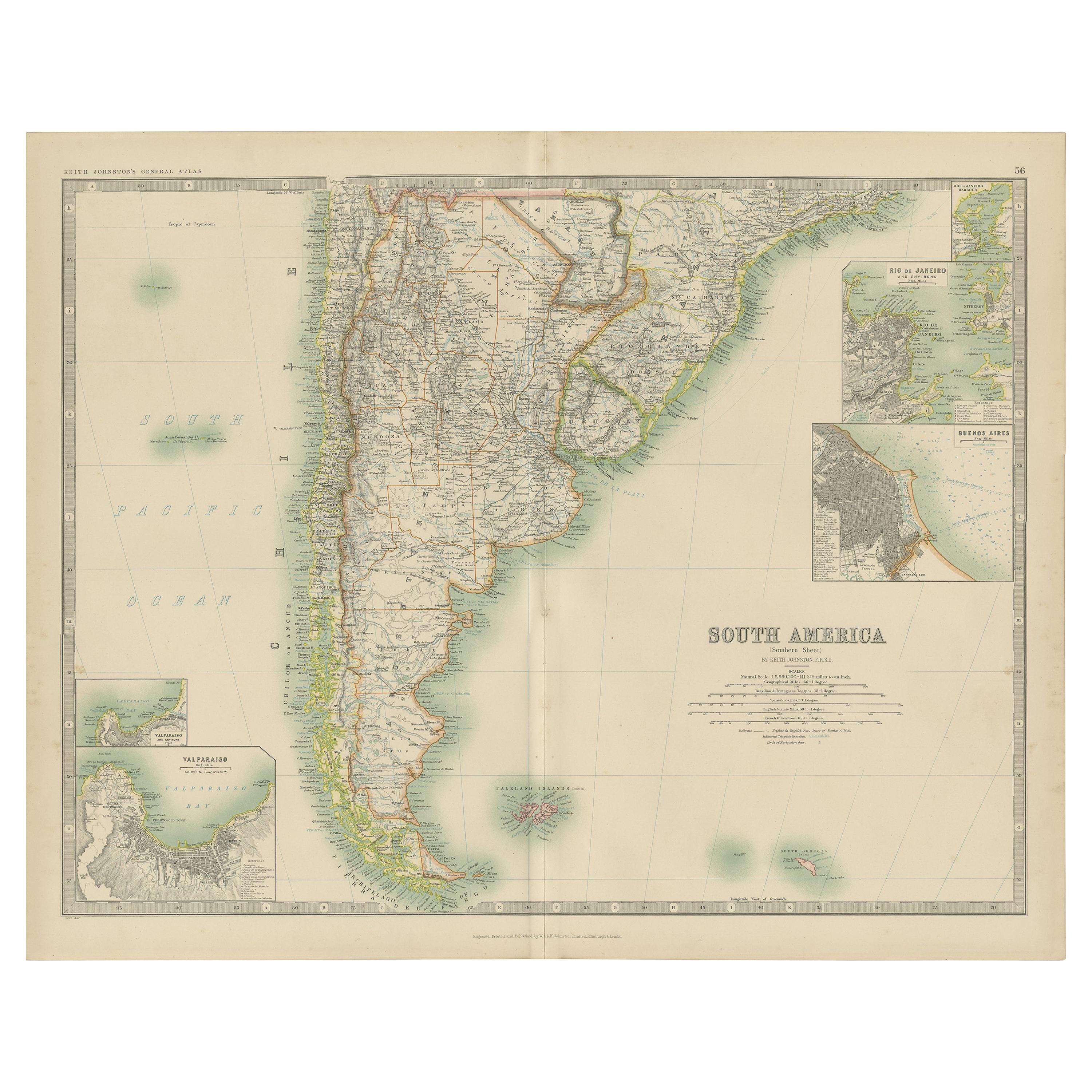
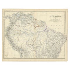
This elegant map titled "South America: Southern Sheet" was created by Keith Johnston, F.R.G.S., and published by W. & A.K. Johnston, Limited, Edinburgh & London, in 1903. It offers a meticulous and visually engaging depiction of the southern part of the South American continent, encompassing Argentina, Chile, Uruguay, and parts of Paraguay and southern Brazil.
The map captures key features such as the rugged Andes mountain range running along Chile’s border, the vast Pampas of Argentina, and the intricate coastline dotted with islands and inlets. In the southern reaches, the map details the archipelagos of Tierra del Fuego and the isolated Falkland Islands and South Georgia Island in the South Atlantic.
Rich with period-accurate details, the map includes rivers, mountain ranges, cities, and transportation routes. Its finely engraved lines and gentle color shading bring the topography and political boundaries to life, offering a striking visual representation of early 20th-century South America.
Condition-wise, the map is in excellent shape for its age, with clear printing, vibrant colors, and minimal signs of handling or foxing. This map’s historical and geographical significance makes it a prized addition to any collection.
For framing, consider using a warm-toned wooden frame or a dark brown frame to complement the map’s elegant color scheme, with a neutral mat to highlight the fine engravings. Whether displayed in a study, library, or office, this map is a captivating window into the landscapes and political divisions of South America at the dawn of the 20th century.
- Maße:Höhe: 36,8 cm (14,49 in)Breite: 47 cm (18,51 in)Tiefe: 0,2 mm (0,01 in)
- Materialien und Methoden:
- Zeitalter:
- Herstellungsjahr:1903
- Zustand:Condition-wise, the map is in excellent shape for its age, with clear printing, vibrant colors, and minimal signs of handling or foxing. This map’s historical and geographical significance makes it a prized addition to any collection.
- Anbieterstandort:Langweer, NL
- Referenznummer:Anbieter*in: BG-13577-511stDibs: LU3054345292142
Anbieterinformationen
5,0
Anerkannte Anbieter*innen
Diese renommierten Anbieter*innen sind führend in der Branche und repräsentieren die höchste Klasse in Sachen Qualität und Design.
Gold-Anbieter*in
Premium-Anbieter*innen mit einer Bewertung über 4,3 und 24 Stunden Reaktionszeit
Gründungsjahr 2009
1stDibs-Anbieter*in seit 2017
2.462 Verkäufe auf 1stDibs
Typische Antwortzeit: <1 Stunde
- VersandAngebot wird abgerufen …Versand von: Langweer, Niederlande
- Rückgabebedingungen
Einige Inhalte dieser Seite wurden automatisch übersetzt. Daher kann 1stDibs nicht die Richtigkeit der Übersetzungen garantieren. Englisch ist die Standardsprache dieser Website.
Authentizitätsgarantie
Im unwahrscheinlichen Fall eines Problems mit der Echtheit eines Objekts kontaktieren Sie uns bitte innerhalb von 1 Jahr für eine volle Rückerstattung. DetailsGeld-Zurück-Garantie
Wenn Ihr Objekt nicht der Beschreibung entspricht, beim Transport beschädigt wurde oder nicht ankommt, kontaktieren Sie uns bitte innerhalb von 7 Tagen für eine vollständige Rückerstattung. DetailsStornierung innerhalb von 24 Stunden
Sie können Ihren Kauf jederzeit innerhalb von 24 Stunden stornieren, ohne jegliche Gründe dafür angeben zu müssen.Geprüfte Anbieter*innen
Unsere Anbieter*innen unterliegen strengen Dienstleistungs- und Qualitätsstandards, wodurch wir die Seriosität unserer Angebote gewährleisten können.Preisgarantie
Wenn Sie feststellen, dass ein*e Anbieter*in dasselbe Objekt anderswo zu einem niedrigeren Preis anbietet, werden wir den Preis entsprechend anpassen.Zuverlässige weltweite Lieferung
Unsere erstklassigen Versandunternehmen bieten spezielle Versandoptionen weltweit, einschließlich individueller Lieferung.Mehr von diesem*dieser Anbieter*in
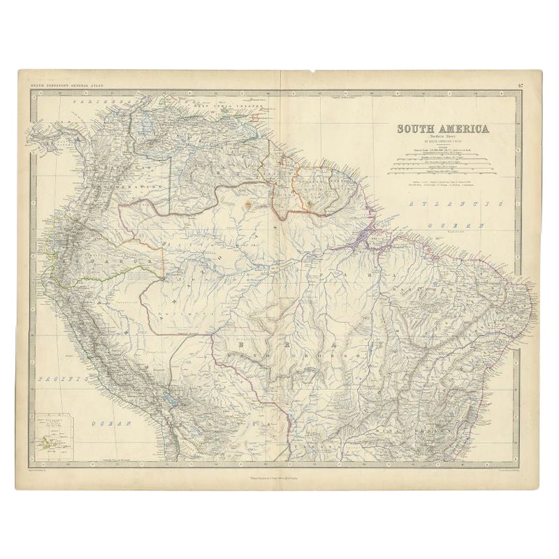
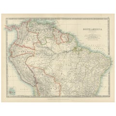
Alle anzeigenMap of Northern South America – Vibrant Engraving by Keith Johnston, 1903
Map of Northern South America – Vibrant Engraving by Keith Johnston, 1903
This beautifully engraved map titled "South America: Northern Sheet" was created by Keith Johnston, F.R.G.S...
Kategorie
Frühes 20. Jahrhundert, Landkarten
Materialien
Papier
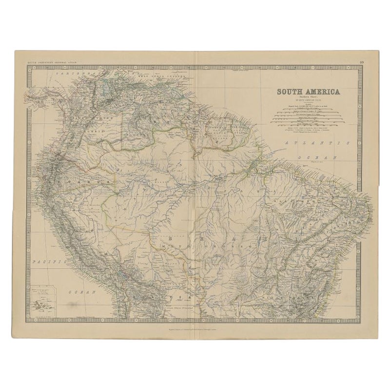
Antike Karte Südamerikas von Johnston '1909'
Antike Karte mit dem Titel 'Südamerika, südliches Blatt'. Chile, Argentinien, Brasilien, Patagonien, die Falklandinseln und mehr. Mit beigefügten Karten von Valparaiso, Rio de Janeir...
Kategorie
Frühes 20. Jahrhundert, Landkarten
Materialien
Papier
232 $ Angebotspreis
20 % Rabatt
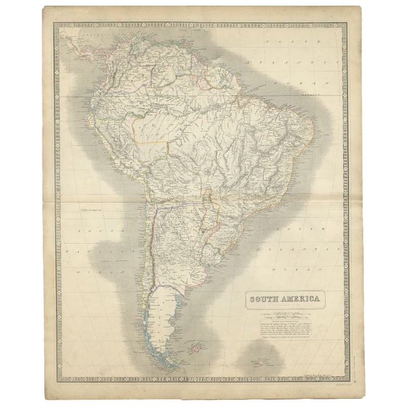
Antike Karte Südamerikas von Johnston, 1882
Antike Karte mit dem Titel 'Südamerika'. Alte Karte von Südamerika, mit einer Karte der Galapagos-Inseln. Diese Karte stammt aus "The Royal Atlas of Modern Geography, Exhibiting, in ...
Kategorie
Antik, 19. Jahrhundert, Landkarten
Materialien
Papier
133 $ Angebotspreis
20 % Rabatt
Antike Karte von Südamerika von Johnston, 1861
Antike Karte mit dem Titel 'Südamerika'.
Alte Karte von Südamerika, mit einer Karte der Galapagos-Inseln. Diese Karte stammt aus "The Royal Atlas of Modern Geography, Exhibiting, i...
Kategorie
Antik, 19. Jahrhundert, Landkarten
Materialien
Papier
Antike Karte von Südamerika von Johnston, 1844
Antitique-Karte mit dem Titel 'Südamerika'. Schöne original antike Landkarte von Südamerika. Diese Karte stammt aus "The National Atlas of Historical, Commercial and Political Geogra...
Kategorie
Antik, 19. Jahrhundert, Landkarten
Materialien
Papier

181 $ Angebotspreis
20 % Rabatt
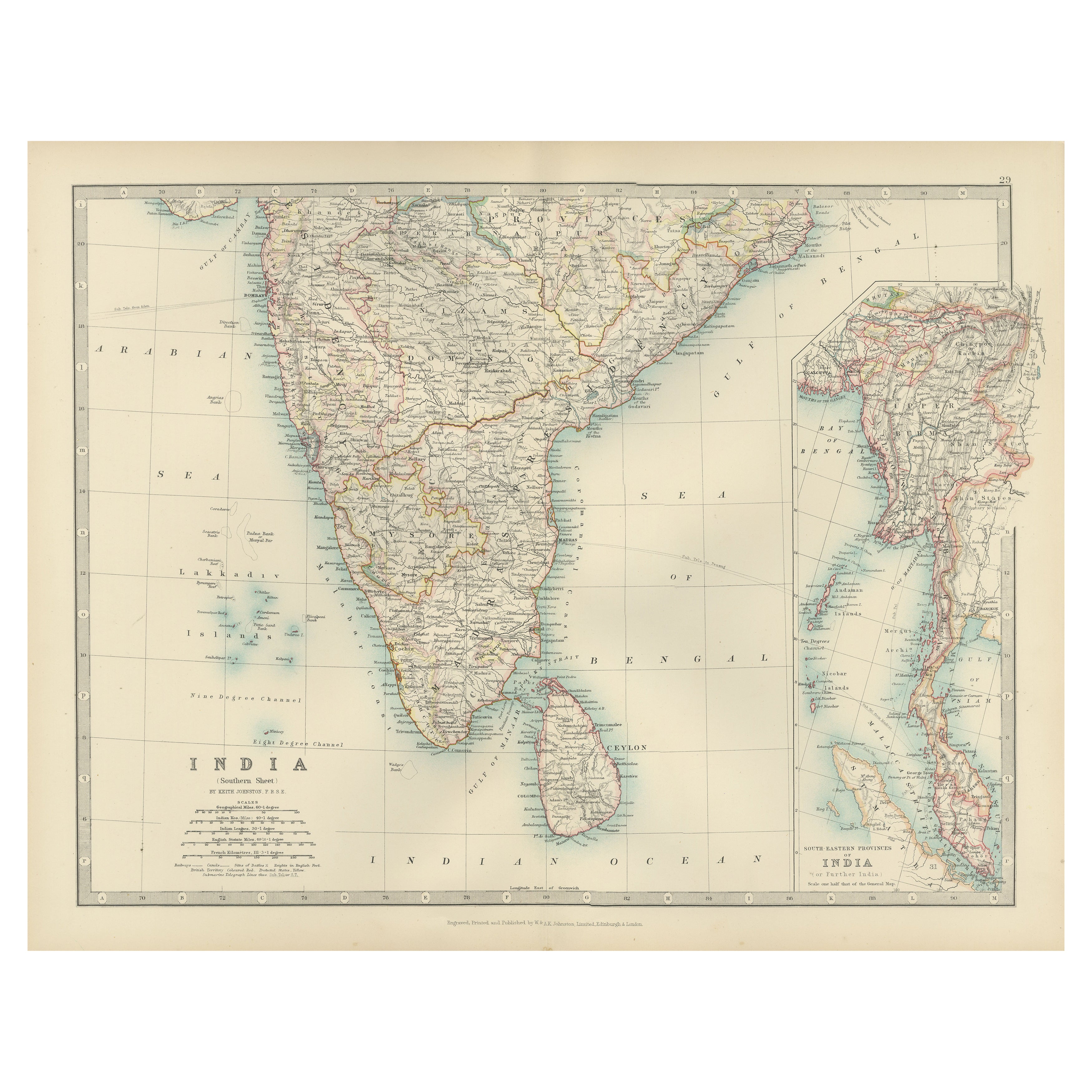
Antique Map of Southern India and South Eastern Provinces, 1903
Title: Antique Map of Southern India and South Eastern Provinces, 1903, with Intricate Detail
Description:
This antique map, titled "India (Southern Sheet) and the South Eastern Pro...
Kategorie
Frühes 20. Jahrhundert, Landkarten
Materialien
Papier
Das könnte Ihnen auch gefallen
Original Antike Karte des amerikanischen Staates Michigan ( Südteil ), 1903
Antike Karte von Michigan (südlicher Teil)
Veröffentlicht von A & C Black. 1903
Original Farbe
Guter Zustand
Ungerahmt.
Kostenloser Versand
Kategorie
Antik, Frühes 20. Jhdt., Englisch, Landkarten
Materialien
Papier

Original Antike Karte des amerikanischen Staates Ohio ( Südteil ), 1903
Antike Karte von Ohio (südlicher Teil)
Veröffentlicht von A & C Black. 1903
Original Farbe
Guter Zustand
Ungerahmt.
Kostenloser Versand
Kategorie
Antik, Frühes 20. Jhdt., Englisch, Landkarten
Materialien
Papier

Original Antike Karte des amerikanischen Staates Kalifornien (Teil Südkaliforniens), 1903
Antike Karte von Kalifornien (südlicher Teil)
Veröffentlicht von A & C Black. 1903
Original Farbe
Guter Zustand
Ungerahmt.
Kostenloser Versand
Kategorie
Antik, Frühes 20. Jhdt., Englisch, Landkarten
Materialien
Papier

49 $
Kostenloser Versand
Original Antike Karte des amerikanischen Staates Illinois ( Südteil ), 1903
Antike Karte von Illinois (südlicher Teil)
Veröffentlicht von A & C Black. 1903
Original Farbe
Guter Zustand
Ungerahmt.
Kostenloser Versand
Kategorie
Antik, Frühes 20. Jhdt., Englisch, Landkarten
Materialien
Papier

Original Antike Karte des amerikanischen Staates Missouri (Teil Südamerikas), 1903
Antike Landkarte von Missouri ( Südlicher Teil )
Veröffentlicht von A & C Black. 1903
Original Farbe
Guter Zustand
Ungerahmt.
Kostenloser Versand
Kategorie
Antik, Frühes 20. Jhdt., Englisch, Landkarten
Materialien
Papier

49 $
Kostenloser Versand
Original Antike Karte des amerikanischen Staates South Carolina, 1903
Antique map of South Carolina
Published By A & C Black. 1903
Original colour
Good condition
Unframed.
Free shipping
Kategorie
Antik, Frühes 20. Jhdt., Englisch, Landkarten
Materialien
Papier
