Objekte ähnlich wie Map of the West India Islands and Central America – Colorful 1903 Engraving


Möchten Sie mehr Bilder oder Videos?
Zusätzliche Bilder oder Videos von dem*der Anbieter*in anfordern
1 von 10
Map of the West India Islands and Central America – Colorful 1903 Engraving
Angaben zum Objekt
Map of the West India Islands and Central America – Colorful 1903 Engraving
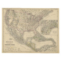
This vibrant engraved map, titled "West India Islands and Central America," was created by Keith Johnston, F.R.G.S., and published by W. & A.K. Johnston, Limited, Edinburgh & London, in 1903. The map offers a detailed depiction of the Caribbean region and Central America at the dawn of the 20th century, skillfully blending geographic accuracy with artistic charm.
The map captures the entire Caribbean basin, stretching from the southern tip of Florida to the shores of South America. It includes the major islands of Cuba, Hispaniola, Jamaica, Puerto Rico, the Bahamas, the Lesser Antilles, and parts of Central America like the Yucatán Peninsula, Honduras, Nicaragua, Costa Rica, and Panama. Intricately engraved lines represent the coastlines, rivers, and mountain ranges, while soft pastel color washes highlight the different political regions, adding clarity and elegance to the visual composition.
An essential feature is the precise labeling of key cities, settlements, and natural landmarks, reflecting the colonial influences and strategic importance of these islands. The map also delineates ocean currents, islands, and smaller cays that were crucial for trade, navigation, and exploration in this era.
This piece stands out not only for its visual appeal but also for its historical significance, marking a time of shifting colonial powers and growing global trade across the Atlantic and Pacific Oceans. T
The condition of this antique map is excellent, with vibrant color retention, clear typography, and minimal wear along the edges.
For framing, a dark wood or sleek black frame with a neutral mat would elegantly complement the delicate engravings and vibrant colors, making this map a striking addition to a study, library, or coastal home. It’s a compelling artifact of exploration and trade routes that shaped the modern Caribbean and Central America, offering a rich narrative for collectors, historians, or anyone fascinated by the region’s dynamic history.
- Maße:Höhe: 47 cm (18,51 in)Breite: 36,8 cm (14,49 in)Tiefe: 0,2 mm (0,01 in)
- Materialien und Methoden:
- Zeitalter:
- Herstellungsjahr:1903
- Zustand:The condition of this antique map is excellent, with vibrant color retention, clear typography, and minimal wear along the edges.
- Anbieterstandort:Langweer, NL
- Referenznummer:Anbieter*in: BG-13577-491stDibs: LU3054345292032
Anbieterinformationen
5,0
Anerkannte Anbieter*innen
Diese renommierten Anbieter*innen sind führend in der Branche und repräsentieren die höchste Klasse in Sachen Qualität und Design.
Gold-Anbieter*in
Premium-Anbieter*innen mit einer Bewertung über 4,3 und 24 Stunden Reaktionszeit
Gründungsjahr 2009
1stDibs-Anbieter*in seit 2017
2.462 Verkäufe auf 1stDibs
Typische Antwortzeit: <1 Stunde
- VersandAngebot wird abgerufen …Versand von: Langweer, Niederlande
- Rückgabebedingungen
Einige Inhalte dieser Seite wurden automatisch übersetzt. Daher kann 1stDibs nicht die Richtigkeit der Übersetzungen garantieren. Englisch ist die Standardsprache dieser Website.
Authentizitätsgarantie
Im unwahrscheinlichen Fall eines Problems mit der Echtheit eines Objekts kontaktieren Sie uns bitte innerhalb von 1 Jahr für eine volle Rückerstattung. DetailsGeld-Zurück-Garantie
Wenn Ihr Objekt nicht der Beschreibung entspricht, beim Transport beschädigt wurde oder nicht ankommt, kontaktieren Sie uns bitte innerhalb von 7 Tagen für eine vollständige Rückerstattung. DetailsStornierung innerhalb von 24 Stunden
Sie können Ihren Kauf jederzeit innerhalb von 24 Stunden stornieren, ohne jegliche Gründe dafür angeben zu müssen.Geprüfte Anbieter*innen
Unsere Anbieter*innen unterliegen strengen Dienstleistungs- und Qualitätsstandards, wodurch wir die Seriosität unserer Angebote gewährleisten können.Preisgarantie
Wenn Sie feststellen, dass ein*e Anbieter*in dasselbe Objekt anderswo zu einem niedrigeren Preis anbietet, werden wir den Preis entsprechend anpassen.Zuverlässige weltweite Lieferung
Unsere erstklassigen Versandunternehmen bieten spezielle Versandoptionen weltweit, einschließlich individueller Lieferung.Mehr von diesem*dieser Anbieter*in
Alle anzeigenAntike Karte von Zentralamerika und Westindischen Inseln, 1882
Antike Karte mit dem Titel 'Westindische Inseln und Mittelamerika'. Alte Karte von Mittelamerika und den Westindischen Inseln. Diese Karte stammt aus "The Royal Atlas of Modern Geogr...
Kategorie
Antik, 19. Jahrhundert, Landkarten
Materialien
Papier

168 $ Angebotspreis
20 % Rabatt
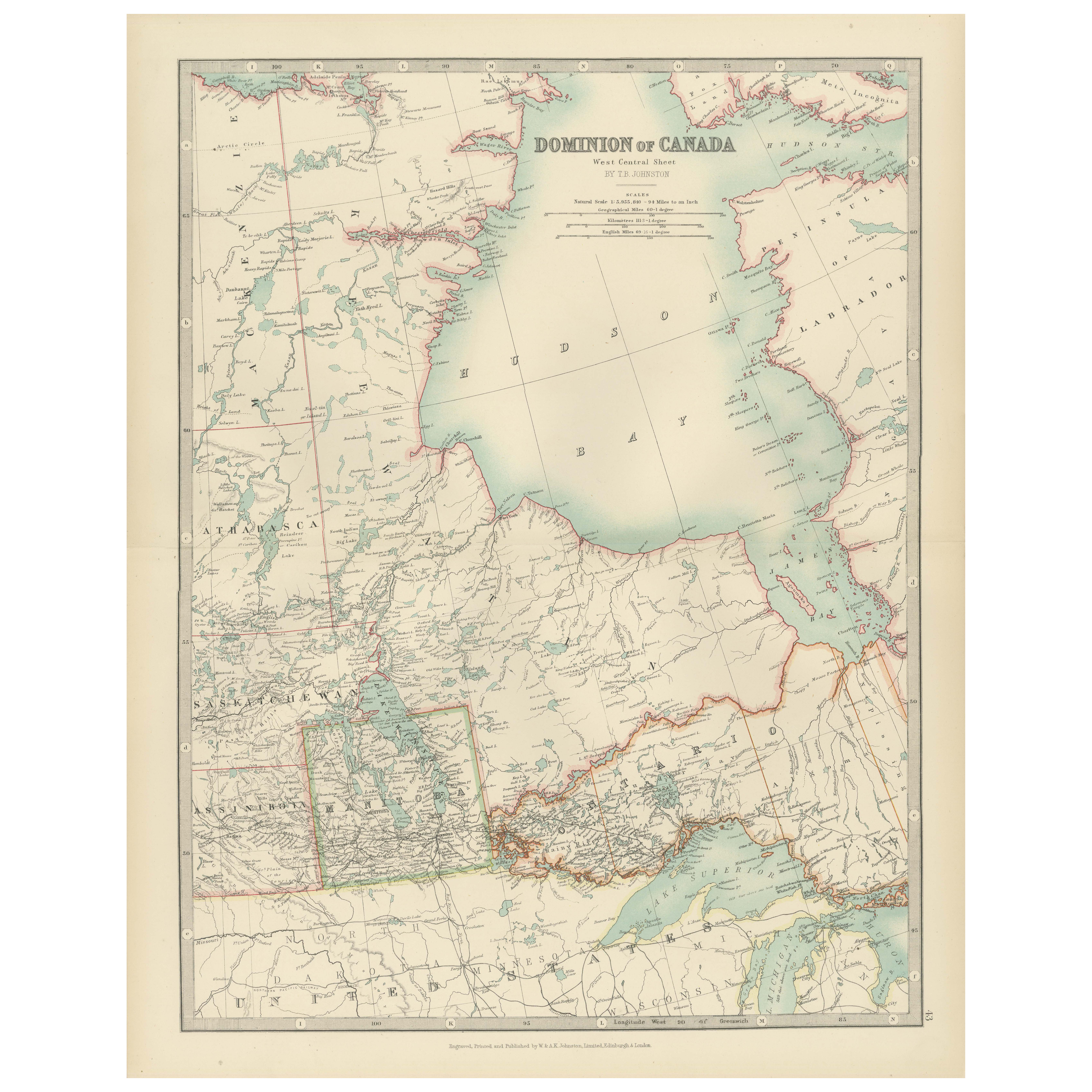
Canada Map 1903 - Dominion of Canada, West Central Sheet
Title: Canada Map 1903 - Dominion of Canada, West Central Sheet
Description:
This fascinating 1903 map of the Dominion of Canada’s West Central regions by T.R. Johnston offers a viv...
Kategorie
Frühes 20. Jahrhundert, Landkarten
Materialien
Papier
Antike Karte von Westindischen Inseln und Zentralamerika von Lowry „1852“
Antike Karte mit dem Titel 'Westindien und Mittelamerika'. Original-Karte der Westindischen Inseln und Mittelamerikas. Diese Karte stammt aus "Lowry's Table Atlas constructed and eng...
Kategorie
Antik, Mittleres 19. Jahrhundert, Landkarten
Materialien
Papier

93 $ Angebotspreis
20 % Rabatt
Antike Karte der Westindischen Inseln und Zentralamerikas von W. G. Blackie, 1859
Antike Karte mit dem Titel 'Die Westindischen Inseln und Mittelamerika'. Antike Original-Landkarte der Westindischen Inseln und Mittelamerikas, mit einer Karte von Jamaika. Diese Kar...
Kategorie
Antik, Mittleres 19. Jahrhundert, Landkarten
Materialien
Papier

233 $ Angebotspreis
20 % Rabatt
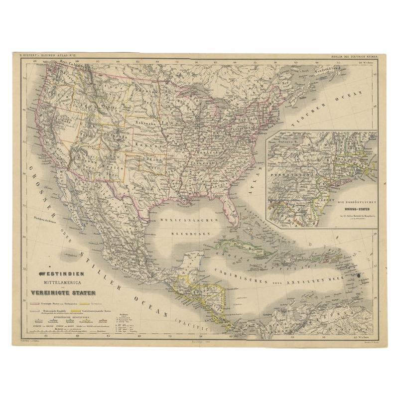
Old German Map of the United States, Central America and the West Indies, um 1870
Antike Karte mit dem Titel 'Westindien, Mittelamerika und Vereinigte Staten'. Alte Karte der Vereinigten Staaten, Mittelamerikas und der Westindischen Inseln. Diese Karte stammt aus ...
Kategorie
Antik, 19. Jahrhundert, Landkarten
Materialien
Papier
Gravur einer Karte von Florida, der Golfküste, der Karibik und Mittelamerika, 1728
Diese außergewöhnliche antike Karte mit dem Titel "Nouvelle Carte Marine de Toute les Cotes de l'Amerique", auch bekannt als "Nieuwe groote en seer Curieuse Paskaart van Geheel-WestI...
Kategorie
Antik, Mitte des 18. Jahrhunderts, Europäisch, Landkarten
Materialien
Papier

12.789 $ Angebotspreis
26 % Rabatt
Kostenloser Versand
Das könnte Ihnen auch gefallen
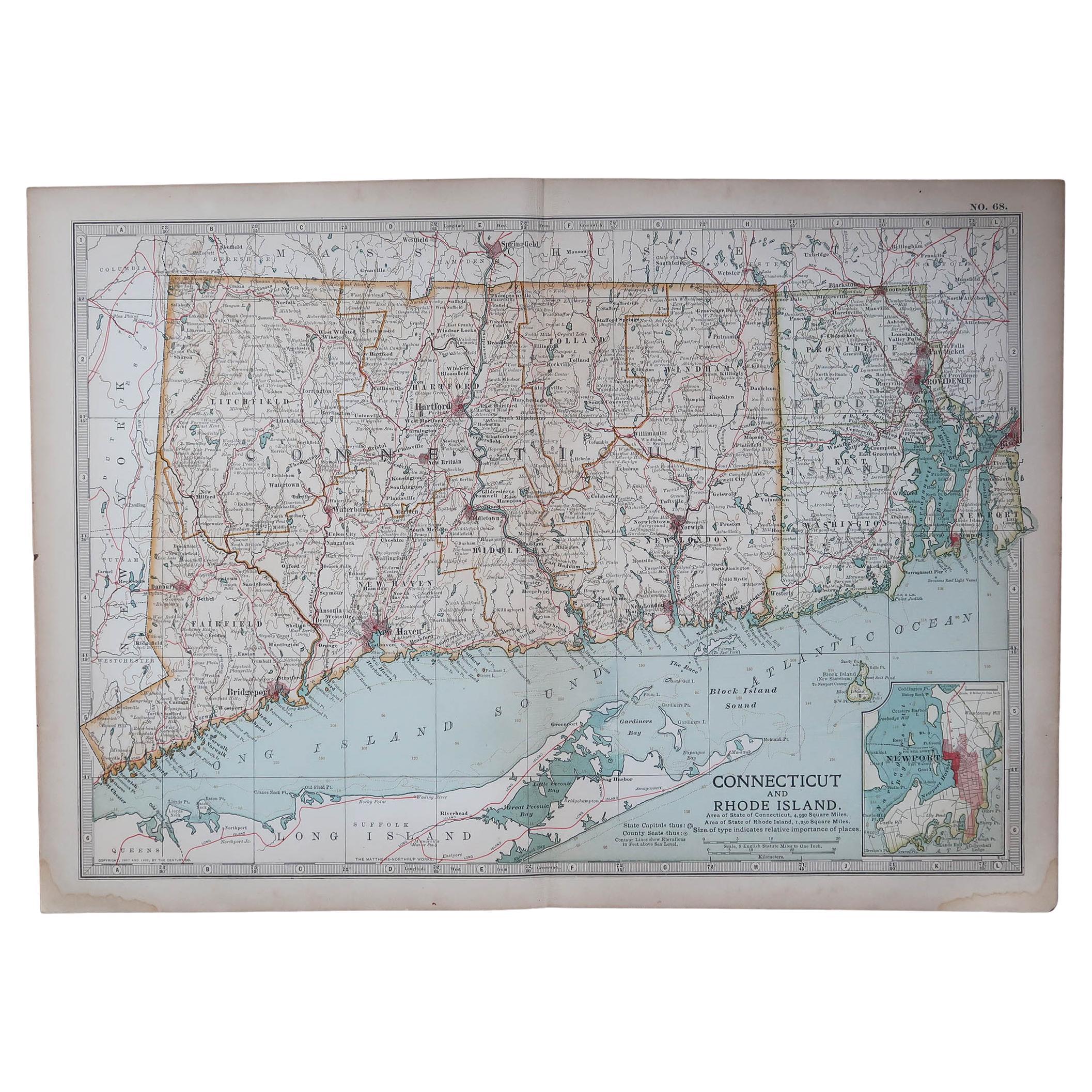
Original Antike Karte des amerikanischen Staates Connecticut und Rhode Island, 1903
Antique map of Connecticut and Rhode Island
Published By A & C Black. 1903
Original colour
Good condition
Unframed.
Free shipping
Kategorie
Antik, Frühes 20. Jhdt., Englisch, Landkarten
Materialien
Papier

49 $
Kostenloser Versand
Original Antike Karte des amerikanischen Staates Minnesota, 1903
Antike Karte von Minnesota
Veröffentlicht von A & C Black. 1903
Original Farbe
Guter Zustand
Ungerahmt.
Kostenloser Versand
Kategorie
Antik, Frühes 20. Jhdt., Englisch, Landkarten
Materialien
Papier

Original Antike Karte des amerikanischen Staates Alabama, 1903
Antique map of Alabama
Published By A & C Black. 1903
Original colour
Good condition
Unframed.
Free shipping
Kategorie
Antik, Frühes 20. Jhdt., Englisch, Landkarten
Materialien
Papier

Original Antike Karte des amerikanischen Staates Alaska, 1903
Antike Karte von Alaska
Veröffentlicht von A & C Black. 1903
Original Farbe
Guter Zustand
Ungerahmt.
Kostenloser Versand
Kategorie
Antik, Frühes 20. Jhdt., Englisch, Landkarten
Materialien
Papier

Original Antike Karte des amerikanischen Staates Nebraska, 1903
Antike Karte von Nebraska
Veröffentlicht von A & C Black. 1903
Original Farbe
Guter Zustand
Ungerahmt.
Kostenloser Versand
Kategorie
Antik, Frühes 20. Jhdt., Englisch, Landkarten
Materialien
Papier

Antike Karte des amerikanischen Staates Washington, 1903
Antike Karte von Washington
Veröffentlicht von A & C Black. 1903
Original Farbe
Guter Zustand
Ungerahmt.
Kostenloser Versand
Kategorie
Antik, Frühes 20. Jhdt., Englisch, Landkarten
Materialien
Papier
