Objekte ähnlich wie Map of United States Central Sheet 1903 – Railroads, States, and Topography


Möchten Sie mehr Bilder oder Videos?
Zusätzliche Bilder oder Videos von dem*der Anbieter*in anfordern
1 von 10
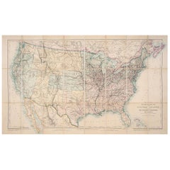
Map of United States Central Sheet 1903 – Railroads, States, and Topography
Angaben zum Objekt
Map of United States Central Sheet 1903 – Railroads, States, and Topography
This is a finely engraved and beautifully colored map titled "United States of North America (Central Sheet)," created by Keith Johnston and printed by W. & A.K. Johnston, Ltd., in London and Edinburgh. This antique map, dating to the early 20th century, showcases the heartland of the United States in meticulous detail, spanning from the Gulf of Mexico up through the Great Lakes region.
The map covers the states of Texas, Oklahoma, Kansas, Nebraska, the Dakotas, Minnesota, Wisconsin, Iowa, Missouri, and Illinois, with surrounding areas of Colorado, Wyoming, Michigan, Arkansas, and Louisiana. Key features include railroad networks that highlight the rapid industrial expansion of the time, major rivers and mountain ranges, county boundaries, and settlements. The shading and contouring beautifully depict the topography, while delicate hand-coloring demarcates state boundaries with elegant clarity.
Inset with a detailed scale and a small table of mileages, the map is a testament to both the artistry and precision of historical cartography. The typography is crisp and classic, conveying both geographical and cultural importance for historians, map enthusiasts, and collectors.
Condition is very good for its age, with only minimal signs of wear and slight toning around the edges, consistent with gentle handling over the decades. The colors remain vibrant, enhancing the visual appeal of this historical piece.
For framing, consider a traditional dark wood frame to complement the antique style, or a simple black frame to modernize the look while preserving the map’s elegance. A neutral cream or off-white mat would highlight the engraved details and colors. This map would make a wonderful display for a home library, study, or any setting that celebrates American history.
- Maße:Höhe: 47 cm (18,51 in)Breite: 36,8 cm (14,49 in)Tiefe: 0,2 mm (0,01 in)
- Materialien und Methoden:
- Zeitalter:
- Herstellungsjahr:1903
- Zustand:Condition is very good for its age, with only minimal signs of wear and slight toning around the edges, consistent with gentle handling over the decades. The colors remain vibrant, enhancing the visual appeal of this historical piece.
- Anbieterstandort:Langweer, NL
- Referenznummer:Anbieter*in: BG-13577-471stDibs: LU3054345291852
Anbieterinformationen
5,0
Anerkannte Anbieter*innen
Diese renommierten Anbieter*innen sind führend in der Branche und repräsentieren die höchste Klasse in Sachen Qualität und Design.
Gold-Anbieter*in
Premium-Anbieter*innen mit einer Bewertung über 4,3 und 24 Stunden Reaktionszeit
Gründungsjahr 2009
1stDibs-Anbieter*in seit 2017
2.462 Verkäufe auf 1stDibs
Typische Antwortzeit: <1 Stunde
- VersandAngebot wird abgerufen …Versand von: Langweer, Niederlande
- Rückgabebedingungen
Einige Inhalte dieser Seite wurden automatisch übersetzt. Daher kann 1stDibs nicht die Richtigkeit der Übersetzungen garantieren. Englisch ist die Standardsprache dieser Website.
Authentizitätsgarantie
Im unwahrscheinlichen Fall eines Problems mit der Echtheit eines Objekts kontaktieren Sie uns bitte innerhalb von 1 Jahr für eine volle Rückerstattung. DetailsGeld-Zurück-Garantie
Wenn Ihr Objekt nicht der Beschreibung entspricht, beim Transport beschädigt wurde oder nicht ankommt, kontaktieren Sie uns bitte innerhalb von 7 Tagen für eine vollständige Rückerstattung. DetailsStornierung innerhalb von 24 Stunden
Sie können Ihren Kauf jederzeit innerhalb von 24 Stunden stornieren, ohne jegliche Gründe dafür angeben zu müssen.Geprüfte Anbieter*innen
Unsere Anbieter*innen unterliegen strengen Dienstleistungs- und Qualitätsstandards, wodurch wir die Seriosität unserer Angebote gewährleisten können.Preisgarantie
Wenn Sie feststellen, dass ein*e Anbieter*in dasselbe Objekt anderswo zu einem niedrigeren Preis anbietet, werden wir den Preis entsprechend anpassen.Zuverlässige weltweite Lieferung
Unsere erstklassigen Versandunternehmen bieten spezielle Versandoptionen weltweit, einschließlich individueller Lieferung.Mehr von diesem*dieser Anbieter*in
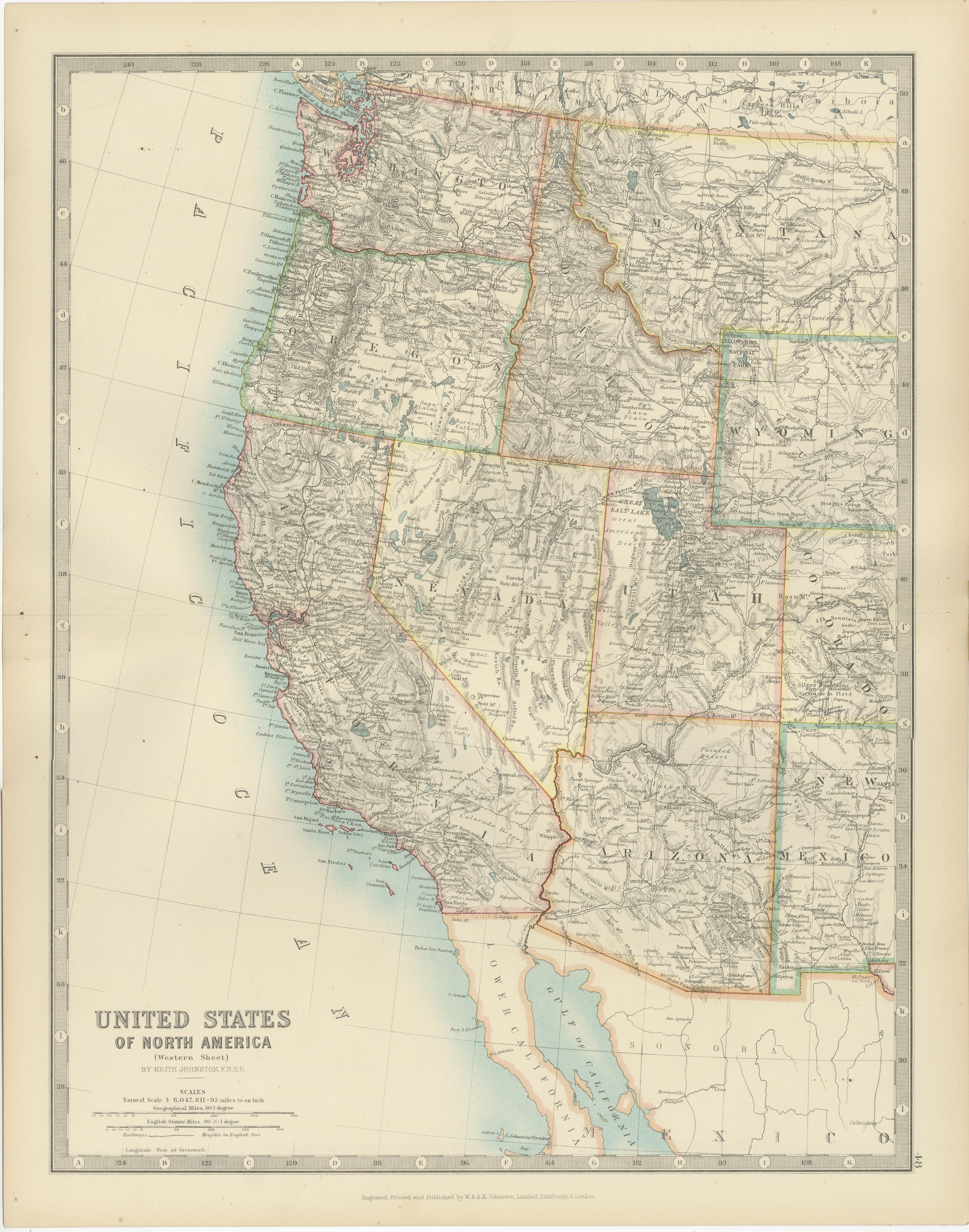
Alle anzeigenMap of Western United States 1903 – Railroads, State Borders, and Terrain
Map of Western United States 1903 – Railroads, State Borders, and Terrain
This beautifully engraved map titled "United States of North America (Western Sheet)" was created by Keith ...
Kategorie
Frühes 20. Jahrhundert, Landkarten
Materialien
Papier

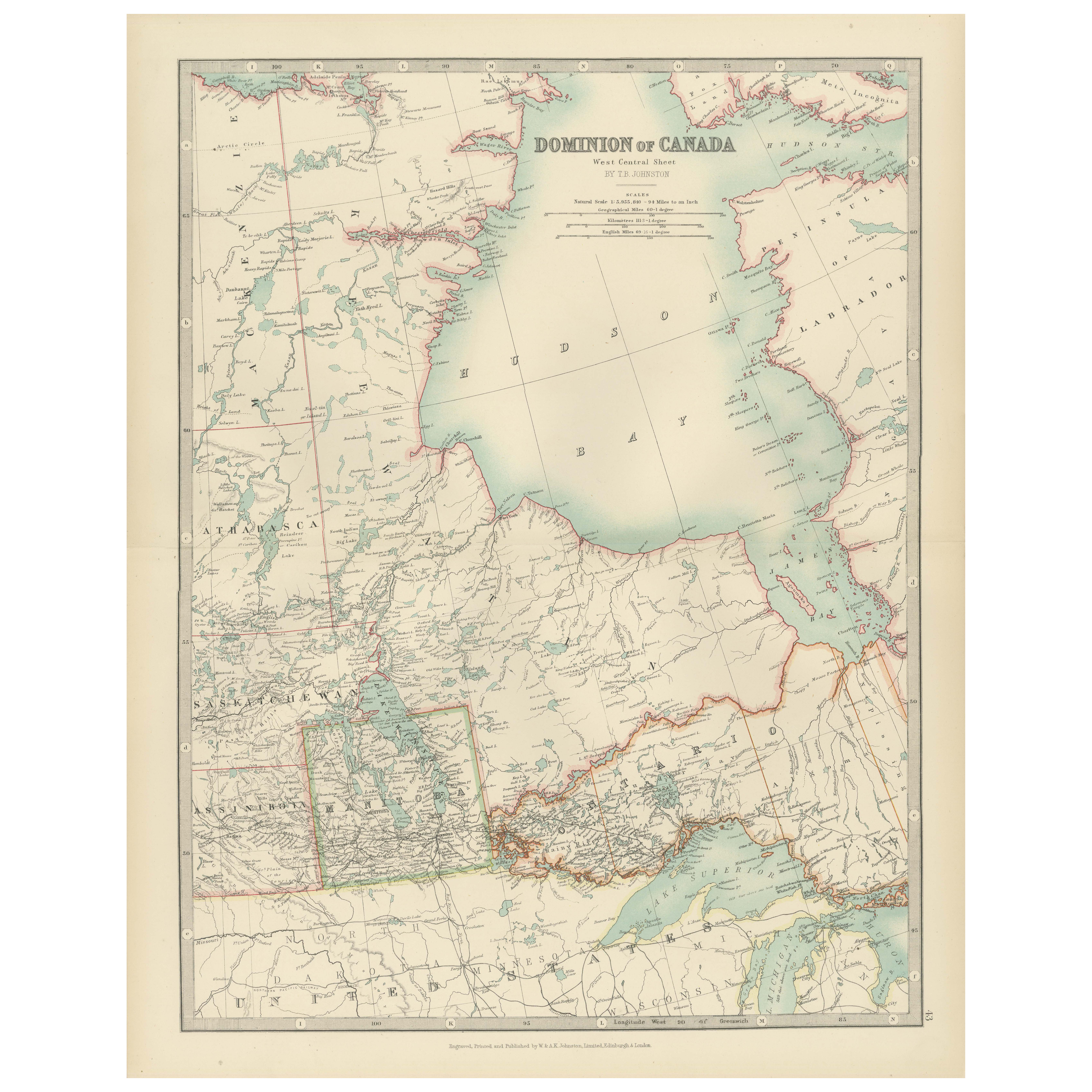
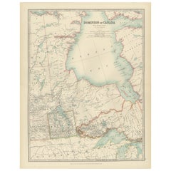
Canada Map 1903 - Dominion of Canada, West Central Sheet
Title: Canada Map 1903 - Dominion of Canada, West Central Sheet
Description:
This fascinating 1903 map of the Dominion of Canada’s West Central regions by T.R. Johnston offers a viv...
Kategorie
Frühes 20. Jahrhundert, Landkarten
Materialien
Papier
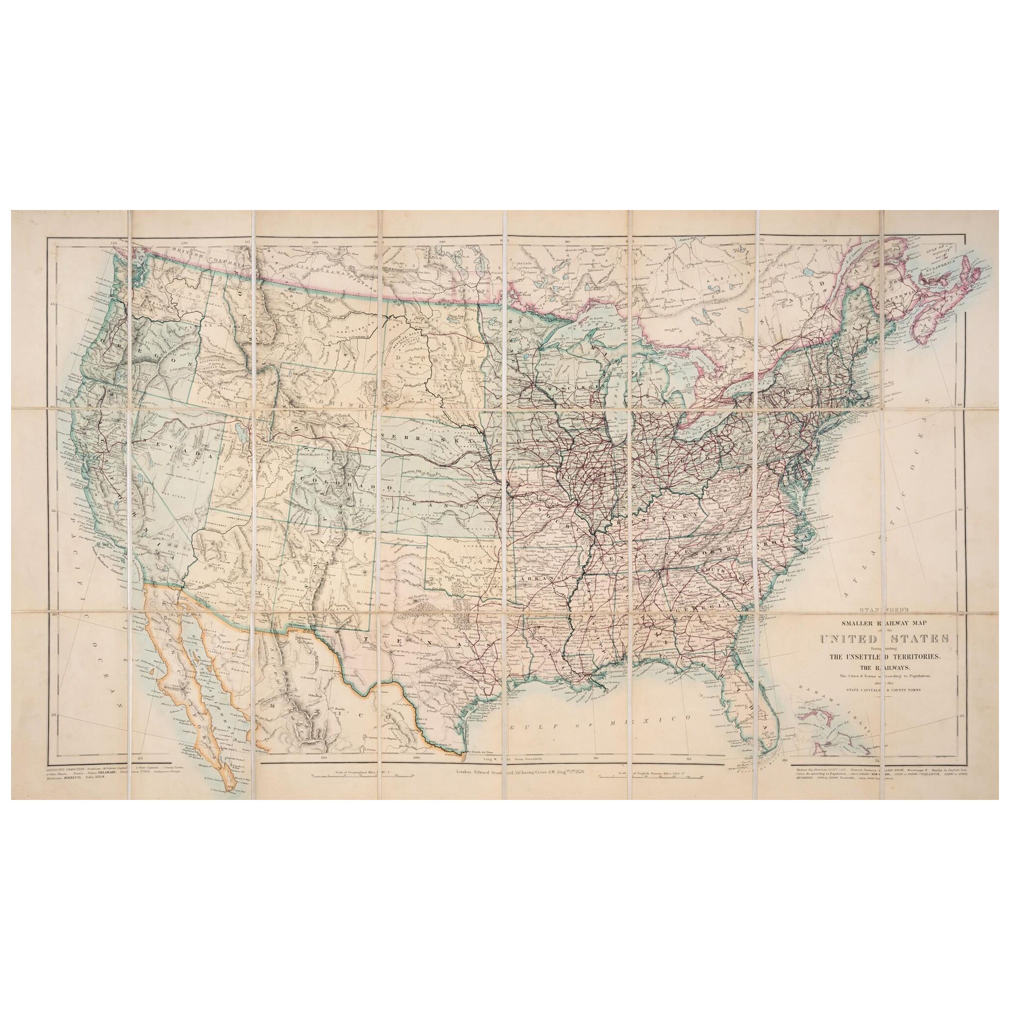
1876 Karte der Vereinigten Staaten: Detaillierte Darstellung der Eisenbahnen und der unbefestigten Territorien
Stanford's Smaller Railway Map of the United States, 1876
Diese Originalkarte von 1876 mit dem Titel "Stanford's Smaller Railway Map of the United States Distinguishing the Unsettle...
Kategorie
Antik, 1870er, Landkarten
Materialien
Papier
Antike Eisenbahnkarte der Vereinigten Staaten von Rand, McNally & Co, 1900
Antike Karte mit dem Titel 'Rand, McNally & Co's New Official Railroad map of the United States with portions of The Dominion of Canada, The Republic of Mexico and the West Indies'. ...
Kategorie
20. Jahrhundert, Landkarten
Materialien
Leinen, Papier

2.187 $ Angebotspreis
25 % Rabatt
Kostenloser Versand
Kleine Karte der Vereinigten Staaten
Antike Karte mit dem Titel 'Amérique septe. Körperbau". Kleine Karte der Vereinigten Staaten. lithographiert von Gebrüder C. Callewaert in Brüssel um 1870.
Kategorie
Antik, Mittleres 19. Jahrhundert, Landkarten
Materialien
Papier

70 $ Angebotspreis
20 % Rabatt
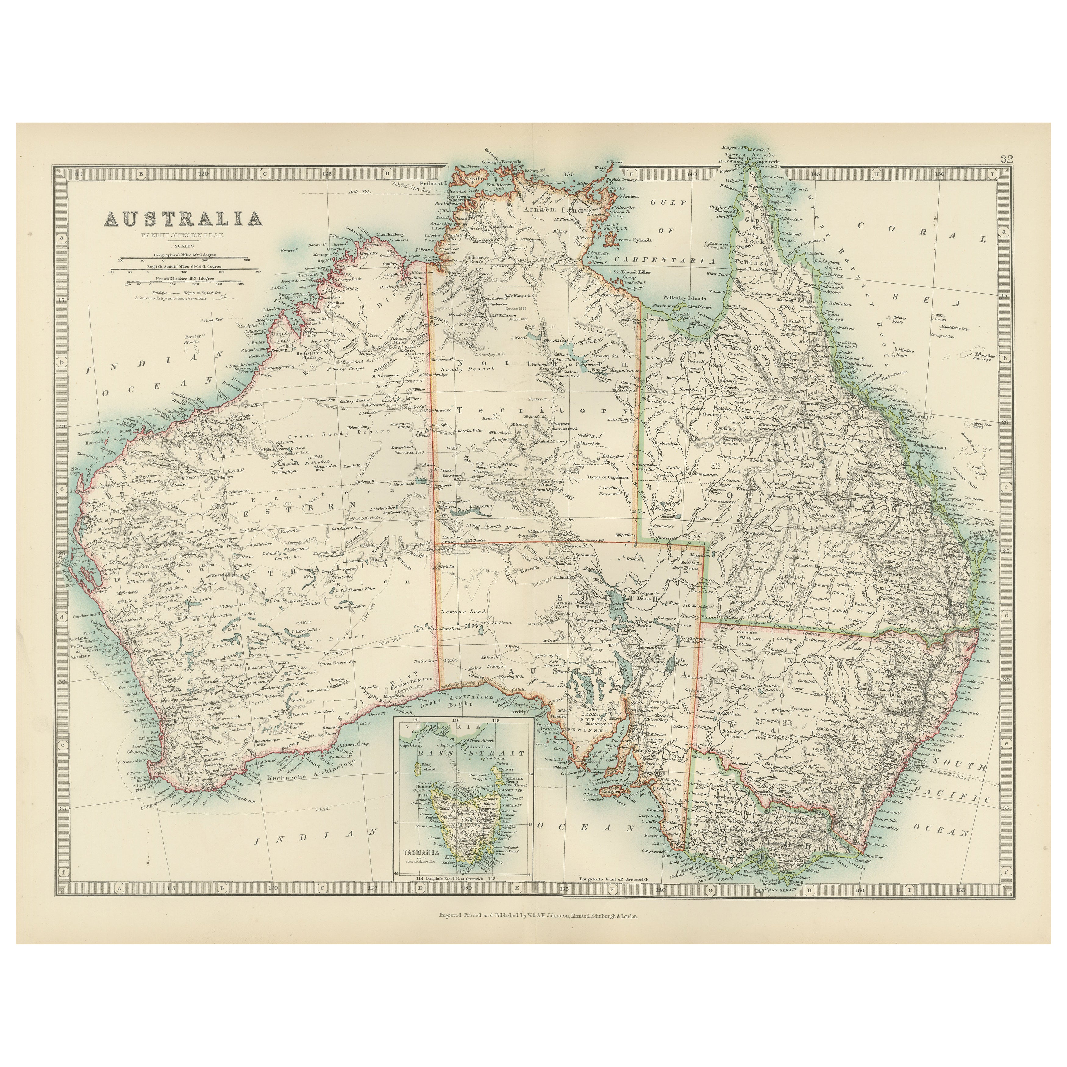
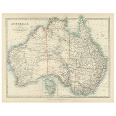
Antique Map of Australia, 1903, with Colonial Divisions and Detailed Topography
Title: Antique Map of Australia, 1903, with Colonial Divisions and Detailed Topography
Description: This antique map, titled "Australia," was engraved and published in 1903 by W. & ...
Kategorie
Frühes 20. Jahrhundert, Landkarten
Materialien
Papier
Das könnte Ihnen auch gefallen
Gerahmte Vintage-Karte der Vereinigten Staaten
Vintage gealterte Papierkarte der Vereinigten Staaten auf Spanplatte montiert und in einem einfachen Holzrahmen gerahmt.
Kategorie
20. Jahrhundert, amerikanisch, Moderne der Mitte des Jahrhunderts, Landk...
Materialien
Holz, Papier

1830 Mexiko und Vereinigte Staaten Gerahmte Karte
Karte von Nordamerika, veröffentlicht um 1830. Die Karte zeigt die Vereinigten Staaten und Kanada. Mexiko, das sich in das Gebiet von Oberkalifornien erstreckt. Texas taucht nur dem ...
Kategorie
Antik, 1830er, amerikanisch, Amerikanische Klassik, Landkarten
Materialien
Glas, Holz, Papier

Antike Karte der Vereinigten Staaten, Grattan und Gilbert, 1843
Große Karte der Vereinigten Staaten
Gezeichnet und gestochen von Archer
Veröffentlicht von Grattan und Gilbert. 1843
Original Farbe
Ungerahmt.
Kategorie
Antik, 1840er, Englisch, Landkarten
Materialien
Papier

Gerahmte handkolorierte Karte der Vereinigten Staaten aus dem Jahr 1820
Gerahmte handkolorierte Kartenfotos von Nordamerika und Südamerika aus den 1820er Jahren. Wie gefunden, gerahmt in Goldholzrahmen.
Kategorie
Antik, 1820er, amerikanisch, Spanisch Kolonial, Landkarten
Materialien
Vergoldetes Holz, Papier, Glas

Gerahmte handkolorierte Karte der Vereinigten Staaten aus dem Jahr 1839
Gerahmte handkolorierte Karte der Vereinigten Staaten von Amerika aus dem Jahr 1839. Neu gerahmt in einem Rahmen aus Goldholz.
Kategorie
Antik, 1830er, amerikanisch, Amerikanische Klassik, Landkarten
Materialien
Vergoldetes Holz, Papier, Glas

1859 „Map of the United States of America..." von J. H. Colton
Von J.H. Colton
Präsentiert wird eine "Karte der Vereinigten Staaten von Amerika, der britischen Provinzen, Mexikos, der Westindischen Inseln und Mittelamerikas mit einem Teil von New Granada und Ve...
Kategorie
Antik, 1850er, amerikanisch, Landkarten
Materialien
Papier
