Objekte ähnlich wie Map of Zurich and Basel Region by Mercator, Uncolored Engraving c.1600


Möchten Sie mehr Bilder oder Videos?
Zusätzliche Bilder oder Videos von dem*der Anbieter*in anfordern
1 von 11
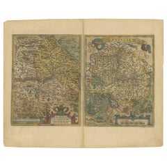
Map of Zurich and Basel Region by Mercator, Uncolored Engraving c.1600
Angaben zum Objekt
Map of Zurich and Basel Region by Mercator, Uncolored Engraving c.1600
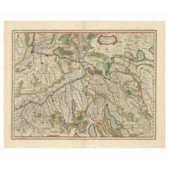
This original uncolored copperplate engraving, titled *Zurichgow et Basiliensis Provincia*, was created by the renowned cartographer Gerardus Mercator and published around 1600 in Amsterdam. The map presents a beautifully detailed rendering of the Swiss regions surrounding Zurich, Basel, and Lucerne, offering a rare early cartographic view of this alpine territory during the Renaissance.
Mercator, one of the most influential figures in the history of cartography, was born in Rupelmonde, Flanders in 1512 and educated in Louvain under the esteemed astronomer and mathematician Gemma Frisius. His scholarly rigor and precise engraving style earned him the patronage of Emperor Charles V. However, his Protestant sympathies led to charges of heresy during the Catholic persecution of Lutheran reformers. After a narrow escape from serious consequences, Mercator relocated to Duisburg in 1552, where he devoted the rest of his life to mapping, scientific instruments, and the production of his famous atlas.
The *Zurichgow et Basiliensis Provincia* map features a rich network of rivers, forests, and mountains depicted in stylized hachures typical of late 16th-century engravings. Key cities such as Zürich, Basel, and Lucerne are prominently marked, as are numerous small towns and geographic landmarks. This map was included in later editions of Mercator's *Atlas sive Cosmographicae*, the first modern atlas. After Mercator's death, his son Rumold carried on his legacy, and in 1604, the plates were acquired by Jodocus Hondius. Hondius and his sons expanded and reissued Mercator’s work, dominating European map publishing well into the mid-17th century.
This sheet is a fine example of early Swiss regional cartography, steeped in both artistic beauty and historical importance. The absence of color allows viewers to appreciate the delicate linework and engraving techniques of Mercator’s workshop.
Condition Report:
Uncolored engraving on laid paper, with even age toning and light spotting near the upper center. Vertical centerfold as issued. Minor edge wear but no tears or repairs. One brown spot, but strong impression and paper in stable condition.
Tips for Framing:
Frame in dark wood or gold-leaf with a cream or ivory archival mat to match the paper’s tone and enhance the historical lines. Avoid bright colors. Museum glass is recommended to protect the antique paper from light and moisture.
- Maße:Höhe: 44,5 cm (17,52 in)Breite: 55 cm (21,66 in)Tiefe: 0,2 mm (0,01 in)
- Materialien und Methoden:Papier,Graviert
- Zeitalter:Frühes 17. Jahrhundert
- Herstellungsjahr:circa 1600
- Zustand:Good uncolored engraving on laid paper, with even age toning and light spotting near the upper center. Vertical centerfold as issued. Minor edge wear but no tears or repairs. One brown spot, but strong impression and paper in stable condition.
- Anbieterstandort:Langweer, NL
- Referenznummer:Anbieter*in: BG-13667-11stDibs: LU3054345323802
Anbieterinformationen
5,0
Anerkannte Anbieter*innen
Diese renommierten Anbieter*innen sind führend in der Branche und repräsentieren die höchste Klasse in Sachen Qualität und Design.
Gold-Anbieter*in
Premium-Anbieter*innen mit einer Bewertung über 4,3 und 24 Stunden Reaktionszeit
Gründungsjahr 2009
1stDibs-Anbieter*in seit 2017
2.467 Verkäufe auf 1stDibs
Typische Antwortzeit: 1 Stunde
- VersandAngebot wird abgerufen …Versand von: Langweer, Niederlande
- Rückgabebedingungen
Einige Inhalte dieser Seite wurden automatisch übersetzt. Daher kann 1stDibs nicht die Richtigkeit der Übersetzungen garantieren. Englisch ist die Standardsprache dieser Website.
Authentizitätsgarantie
Im unwahrscheinlichen Fall eines Problems mit der Echtheit eines Objekts kontaktieren Sie uns bitte innerhalb von 1 Jahr für eine volle Rückerstattung. DetailsGeld-Zurück-Garantie
Wenn Ihr Objekt nicht der Beschreibung entspricht, beim Transport beschädigt wurde oder nicht ankommt, kontaktieren Sie uns bitte innerhalb von 7 Tagen für eine vollständige Rückerstattung. DetailsStornierung innerhalb von 24 Stunden
Sie können Ihren Kauf jederzeit innerhalb von 24 Stunden stornieren, ohne jegliche Gründe dafür angeben zu müssen.Geprüfte Anbieter*innen
Unsere Anbieter*innen unterliegen strengen Dienstleistungs- und Qualitätsstandards, wodurch wir die Seriosität unserer Angebote gewährleisten können.Preisgarantie
Wenn Sie feststellen, dass ein*e Anbieter*in dasselbe Objekt anderswo zu einem niedrigeren Preis anbietet, werden wir den Preis entsprechend anpassen.Zuverlässige weltweite Lieferung
Unsere erstklassigen Versandunternehmen bieten spezielle Versandoptionen weltweit, einschließlich individueller Lieferung.Mehr von diesem*dieser Anbieter*in
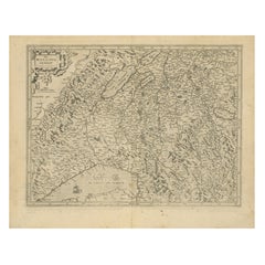
Alle anzeigenMap of Northwestern Switzerland (Basel und Zürich Region) von Willem & Jan Blaeu
Karte der Nordwestschweiz von Willem & Jan Blaeu (CIRCA 1650)
Dies ist eine detaillierte Karte der Nordwestschweiz, insbesondere der Region zwischen Basel und Zürich, die von den be...
Kategorie
Antik, 1650er, Landkarten
Materialien
Papier
884 $ Angebotspreis
30 % Rabatt
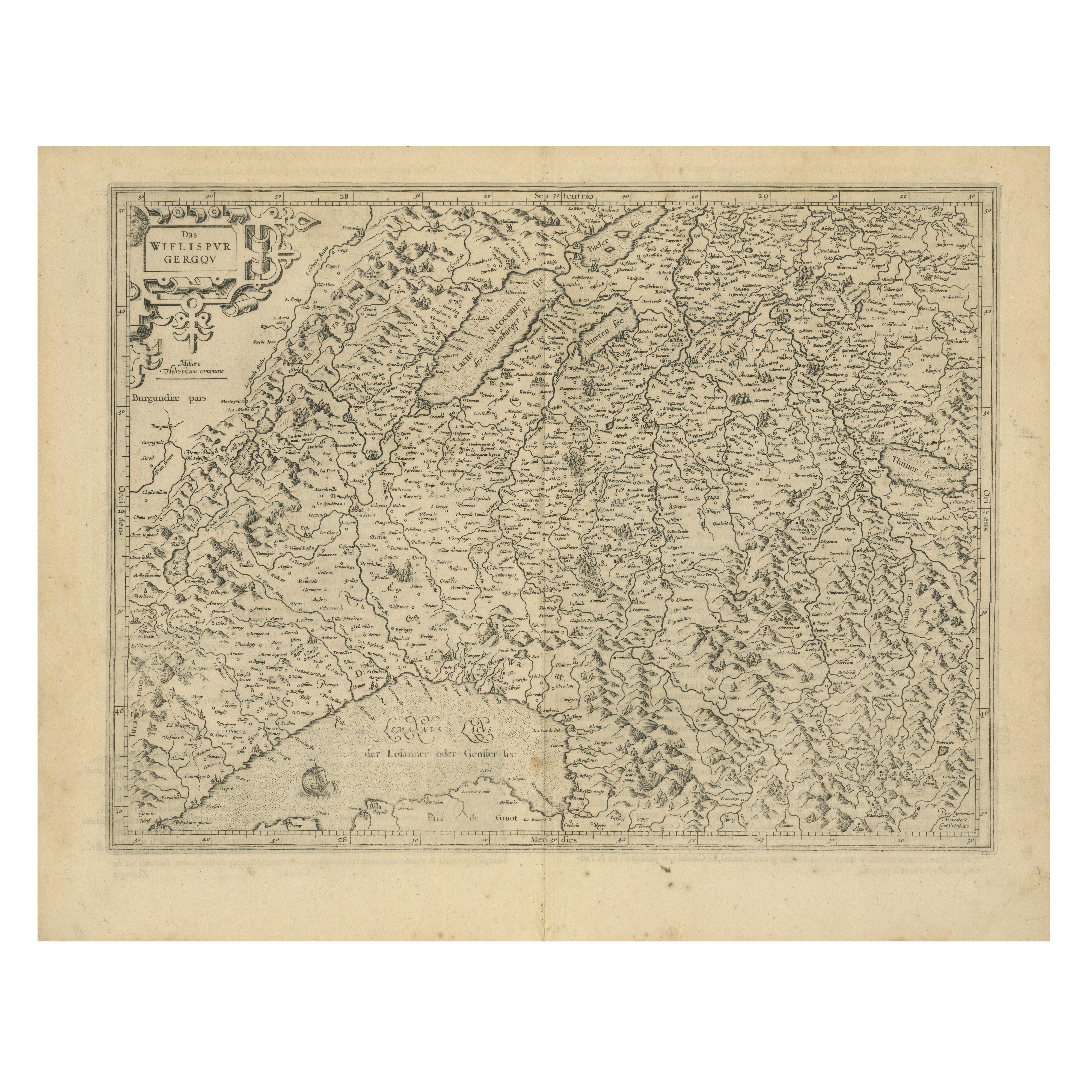
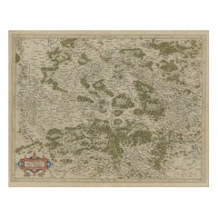
Map of Avenches Region Switzerland by Mercator, Original 1585 Engraving
Map of Wiflispurgergov by Gerardus Mercator, Avenches Region, 1585
This rare and finely engraved map, titled *Das Wiflispurgergov*, was produced by Gerardus Mercator and published i...
Kategorie
Antik, 16. Jahrhundert, Niederländisch, Landkarten
Materialien
Papier
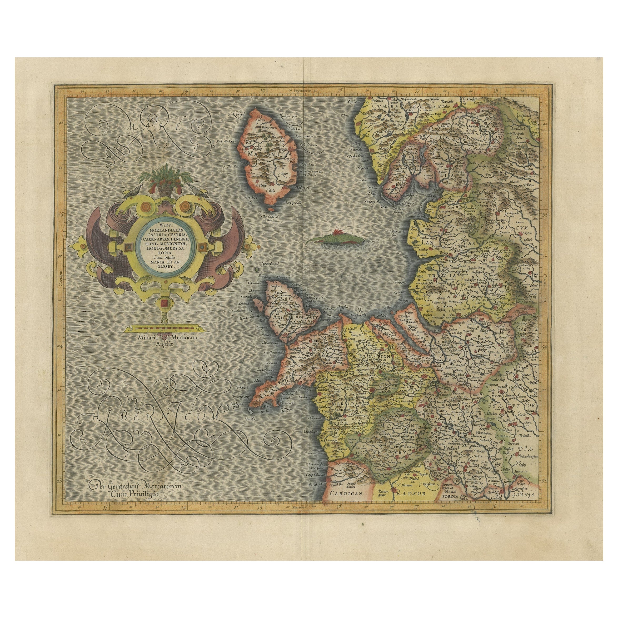
Antike englische Karte von Mercator/Hondius, um 1600
Antike Karte mit dem Titel "Westmorlandia, Lancastria, Caernvan, Denbigh, Flint, Merionidh, Dalopia cum issulis Mania et Anglesey". Original antike Landkarte von England. Dekorative ...
Kategorie
Antik, 16. Jahrhundert, Landkarten
Materialien
Papier

884 $ Angebotspreis
20 % Rabatt
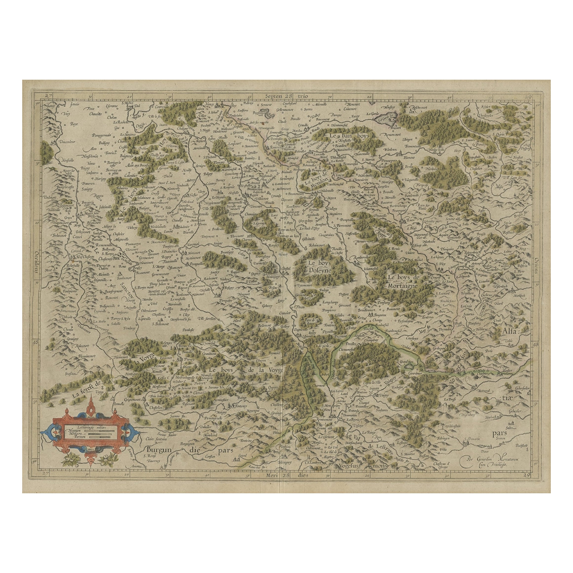
Antike Karte der südlichen Lorraine-Region von Mercator, um 1625
Von Gerard Mercator
Antike Karte mit dem Titel 'Lotharingiae Ducatus'. Alte Karte des südlichen Teils der Region Lothringen, Frankreich. Lothringen ist eine kulturhistorische Region im Nordosten Frankre...
Kategorie
Antik, 17. Jahrhundert, Landkarten
Materialien
Papier
269 $ Angebotspreis
20 % Rabatt
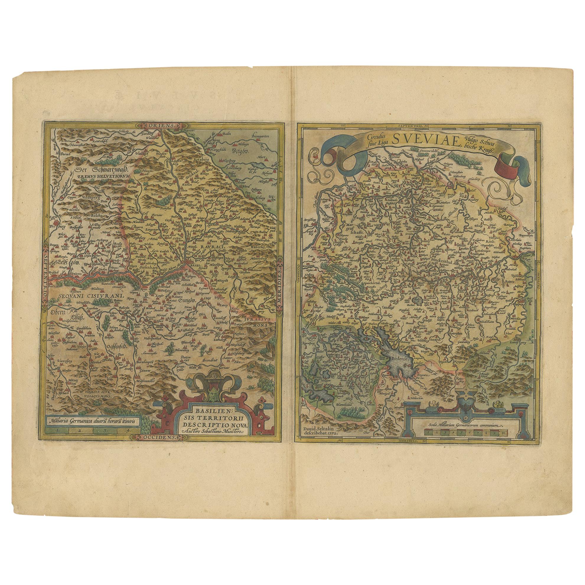
Karte der Region Basel und Nordschweiz von Ortelius, um 1603
Zwei originale antike Karten auf einem Blatt mit dem Titel 'Basiliensis Territorii Descriptio Nova [mit] Circulus sive Liga Sueviae'. Im Mittelpunkt der ersten steht das am Rhein gel...
Kategorie
Antik, Anfang des 17. Jahrhunderts, Landkarten
Materialien
Papier
511 $ Angebotspreis
20 % Rabatt
Antike Karte der Region Poitou von Ortelius, um 1600
Antike Karte mit dem Titel 'Poictou'. Antike Original-Landkarte der Region Poitou, einer ehemaligen Provinz im Westen Zentralfrankreichs, deren Hauptstadt Poitiers war. Herausgegeben...
Kategorie
Antik, Anfang des 17. Jahrhunderts, Landkarten
Materialien
Papier

558 $ Angebotspreis
20 % Rabatt
Das könnte Ihnen auch gefallen
Handkolorierte Karte des Südosten Englands aus dem 17. Jahrhundert von Mercator und Hondius
Von Gerard Mercator
Eine handkolorierte Kupferstichkarte aus dem 17. Jahrhundert mit dem Titel "The Sixt Table of England" von Gerard Mercator und Jodocus Hondius, veröffentlicht 1635 in Amsterdam in "C...
Kategorie
Antik, Mitte 17. Jahrhundert, Niederländisch, Landkarten
Materialien
Papier

Südwestirland: Eine handkolorierte Karte aus dem 17. Jahrhundert von Mercator und Hondius
Von Gerard Mercator
Eine handkolorierte Kupferstichkarte aus dem 17. Jahrhundert mit dem Titel "The Second Table of Ireland, Udrone" von Gerard Mercator und Jodocus Hondius, veröffentlicht 1635 in Amste...
Kategorie
Antik, Mitte 17. Jahrhundert, Niederländisch, Landkarten
Materialien
Papier

Nordschottland: Eine handkolorierte Karte aus dem 17. Jahrhundert von Mercator
Von Gerard Mercator
Dies ist eine gerahmte handkolorierte Karte von Nordschottland aus dem 17. Jahrhundert von Gerard Mercator mit dem Titel "Scotiae pars Septentrionalis", veröffentlicht in Amsterdam i...
Kategorie
Antik, 1630er, Niederländisch, Landkarten
Materialien
Papier

Nordschottland: Eine handkolorierte Karte von Mercator aus dem 16. Jahrhundert
Von Gerard Mercator
Eine gerahmte handkolorierte Karte von Nordschottland aus dem 16. Jahrhundert von Gerard Mercator mit dem Titel "Scotiae pars Septentrionalis", veröffentlicht in Amsterdam im Jahr 16...
Kategorie
Antik, 16. Jahrhundert, Niederländisch, Landkarten
Materialien
Papier

Gerahmte Mercator Hondius Hispania Nova Atlas Kleine Karte
Gerahmtes koloriertes Exemplar dieser dekorativen und wichtigen Miniaturkarte. Neu gerahmt in braunem Holzrahmen mit Goldverzierung.
Mercator Hondius "Atlas Minor" veröffentlicht i...
Kategorie
Antik, 17. Jahrhundert, Niederländisch, Spanisch Kolonial, Landkarten
Materialien
Glas, Holz, Papier

1625 Mercator-Karte der Provenienz von Quercy, „Quercy Cadvrcivm Ric.0013
mercator-Karte der Herkunft von Quercy aus dem Jahr 1625 mit dem Titel
"Quercy Cadvrcivm,"
Ric.0013
" Authentisch" - Karte der Herkunft von Quercy Cadvrcivm
Beschreibung: An...
Kategorie
Antik, 17. Jahrhundert, Französisch, Landkarten
Materialien
Papier