Objekte ähnlich wie Animal Distribution Map by A.K. Johnston – Fauna by Climate Zones 1852


Möchten Sie mehr Bilder oder Videos?
Zusätzliche Bilder oder Videos von dem*der Anbieter*in anfordern
1 von 11
Animal Distribution Map by A.K. Johnston – Fauna by Climate Zones 1852
260 €pro Objekt|Einschließlich MwSt.
Menge
Angaben zum Objekt
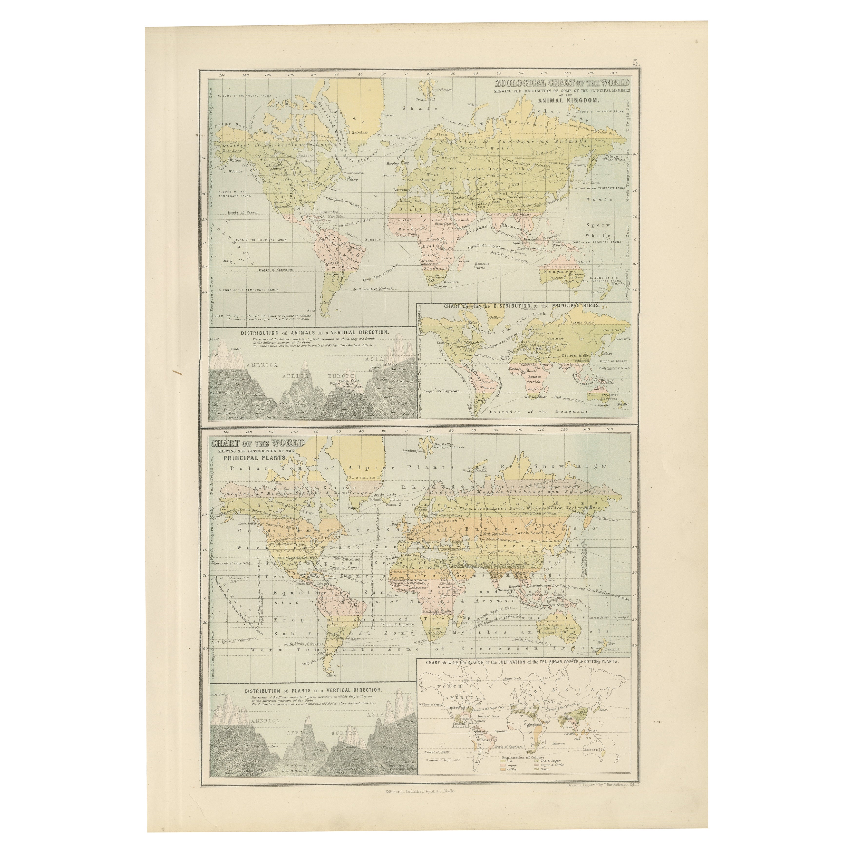
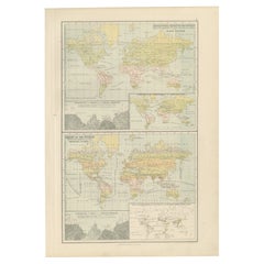
Animal Distribution Map by A.K. Johnston – Fauna by Climate Zones 1852
This beautifully engraved chart titled "The Distribution of Animals Including the Mammalia, Birds, Reptiles & Fishes; According to Zones of Climate" was created by Alexander Keith Johnston and published in 1852 by William Blackwood & Sons, Edinburgh and London. It appears as Plate 16 in Johnston’s influential *Physical Atlas of Natural Phenomena*, one of the most important thematic atlases of the 19th century.
This map presents a global view of the natural distribution of animals based on climatic zones, highlighting how temperature, geography, and elevation influence animal habitats. The world is divided into major climate zones such as the "Temperate Fauna," "Tropical Fauna," and "Zones of Perpetual Ice and Snow," with red typography identifying characteristic species of mammals, birds, reptiles, and marine life in each region.
Notable animal groups are labeled in situ, such as the polar bear, right whale, llama, lion, elephant, condor, kangaroo, and reindeer. Faunal regions across Asia, Africa, the Americas, Australia, and the Arctic are described in broad zoological terms. The map distinguishes between terrestrial and marine fauna, with references to oceanic zones for species like whales and seals, while also noting elevation-related changes in animal life.
Beneath the main map is a detailed comparative diagram titled "Distribution of Animals in a Vertical Direction," showing how animal species vary with altitude across major mountain systems in the Western and Eastern Hemispheres. Mountains like the Andes, Alps, Himalayas, and the Rocky Mountains are illustrated with fauna labeled at different heights—from mountain goats and condors to tigers and leopards—illustrating the vertical stratification of animal habitats.
Alexander Keith Johnston (1804–1871) was a pioneer in thematic cartography and served as Geographer in Ordinary to Queen Victoria. His *Physical Atlas* combined scientific rigor with visual clarity and artistic precision, making complex environmental and biological data both accessible and visually compelling.
This plate is ideal for collectors of natural history, early zoological science, or antique educational prints. It also serves as an elegant decorative piece for libraries, studies, or offices with a scientific or historical theme.
Condition and framing tips:
Very good condition with mild age toning and a clean image area. Original centerfold present. Frame in dark wood or black with a neutral or ivory mat to enhance the subtle red and green tones and the delicate engravings. A fine piece for natural history enthusiasts and vintage map collectors alike.
- Maße:Höhe: 27,4 cm (10,79 in)Breite: 34,5 cm (13,59 in)Tiefe: 0,2 mm (0,01 in)
- Materialien und Methoden:
- Herkunftsort:
- Zeitalter:
- Herstellungsjahr:1852
- Zustand:Very good condition. Light overall toning near the margins and some offset over Europe. The paper remains strong and well-preserved. Folding line as issued.
- Anbieterstandort:Langweer, NL
- Referenznummer:Anbieter*in: BG-13207-161stDibs: LU3054345393532
Anbieterinformationen
5,0
Anerkannte Anbieter*innen
Diese renommierten Anbieter*innen sind führend in der Branche und repräsentieren die höchste Klasse in Sachen Qualität und Design.
Platin-Anbieter*in
Premium-Anbieter*innen mit einer Bewertung über 4,7 und 24 Stunden Reaktionszeit
Gründungsjahr 2009
1stDibs-Anbieter*in seit 2017
2.656 Verkäufe auf 1stDibs
Typische Antwortzeit: <1 Stunde
- VersandAngebot wird abgerufen …Versand von: Langweer, Niederlande
- Rückgabebedingungen
Einige Inhalte dieser Seite wurden automatisch übersetzt. Daher kann 1stDibs nicht die Richtigkeit der Übersetzungen garantieren. Englisch ist die Standardsprache dieser Website.
Authentizitätsgarantie
Im unwahrscheinlichen Fall eines Problems mit der Echtheit eines Objekts kontaktieren Sie uns bitte innerhalb von 1 Jahr für eine volle Rückerstattung. DetailsGeld-Zurück-Garantie
Wenn Ihr Objekt nicht der Beschreibung entspricht, beim Transport beschädigt wurde oder nicht ankommt, kontaktieren Sie uns bitte innerhalb von 7 Tagen für eine vollständige Rückerstattung. DetailsStornierung innerhalb von 24 Stunden
Sie können Ihren Kauf jederzeit innerhalb von 24 Stunden stornieren, ohne jegliche Gründe dafür angeben zu müssen.Geprüfte Anbieter*innen
Unsere Anbieter*innen unterliegen strengen Dienstleistungs- und Qualitätsstandards, wodurch wir die Seriosität unserer Angebote gewährleisten können.Preisgarantie
Wenn Sie feststellen, dass ein*e Anbieter*in dasselbe Objekt anderswo zu einem niedrigeren Preis anbietet, werden wir den Preis entsprechend anpassen.Zuverlässige weltweite Lieferung
Unsere erstklassigen Versandunternehmen bieten spezielle Versandoptionen weltweit, einschließlich individueller Lieferung.Mehr von diesem*dieser Anbieter*in
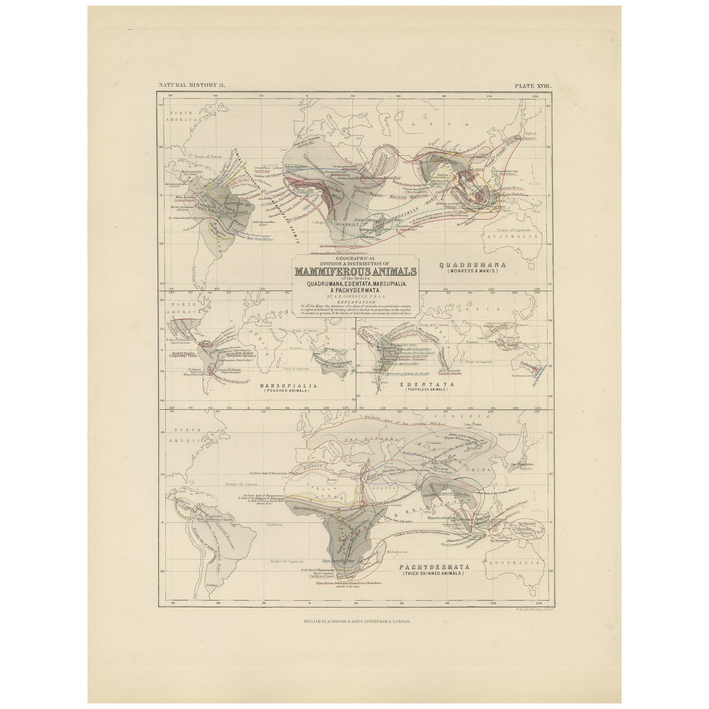
Alle anzeigenAntike Karte mit der Darstellung der Abteilung und der Verteilung von Mammalen von Johnston aus dem Jahr 1850
Antike Karte mit dem Titel "Geografische Einteilung und Verbreitung der Säugetiere der Ordnungen Rodentia und Ruminantia über den Globus". Originale antike Karte mit der geografische...
Kategorie
Antik, Mittleres 19. Jahrhundert, Landkarten
Materialien
Papier

160 € Angebotspreis
20 % Rabatt
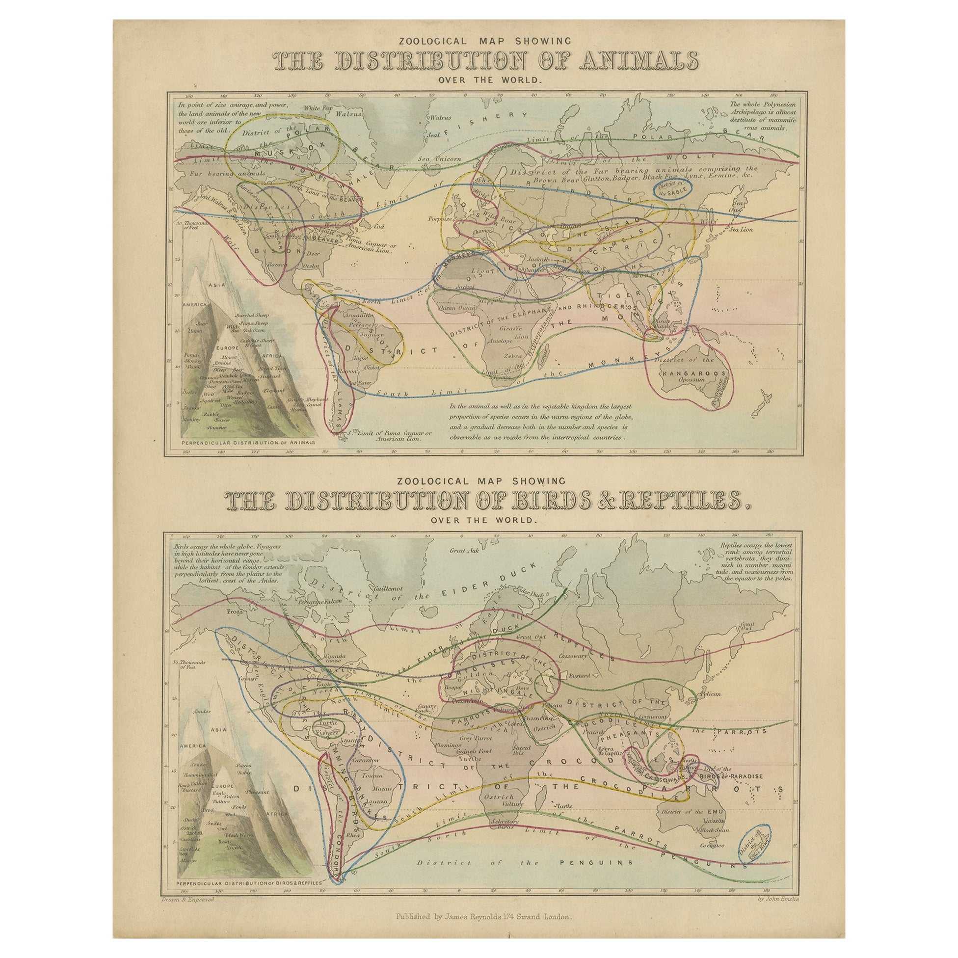
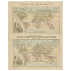
Antike Zoologische Karte, 1843
Zwei antike Weltkarten auf einem Blatt. Die obere Karte zeigt die Verteilung der Tiere auf der Welt. Die untere Karte zeigt die Verbreitung von Vögeln und Reptilien auf der ganzen We...
Kategorie
Antik, 19. Jahrhundert, Landkarten
Materialien
Papier
176 € Angebotspreis
20 % Rabatt
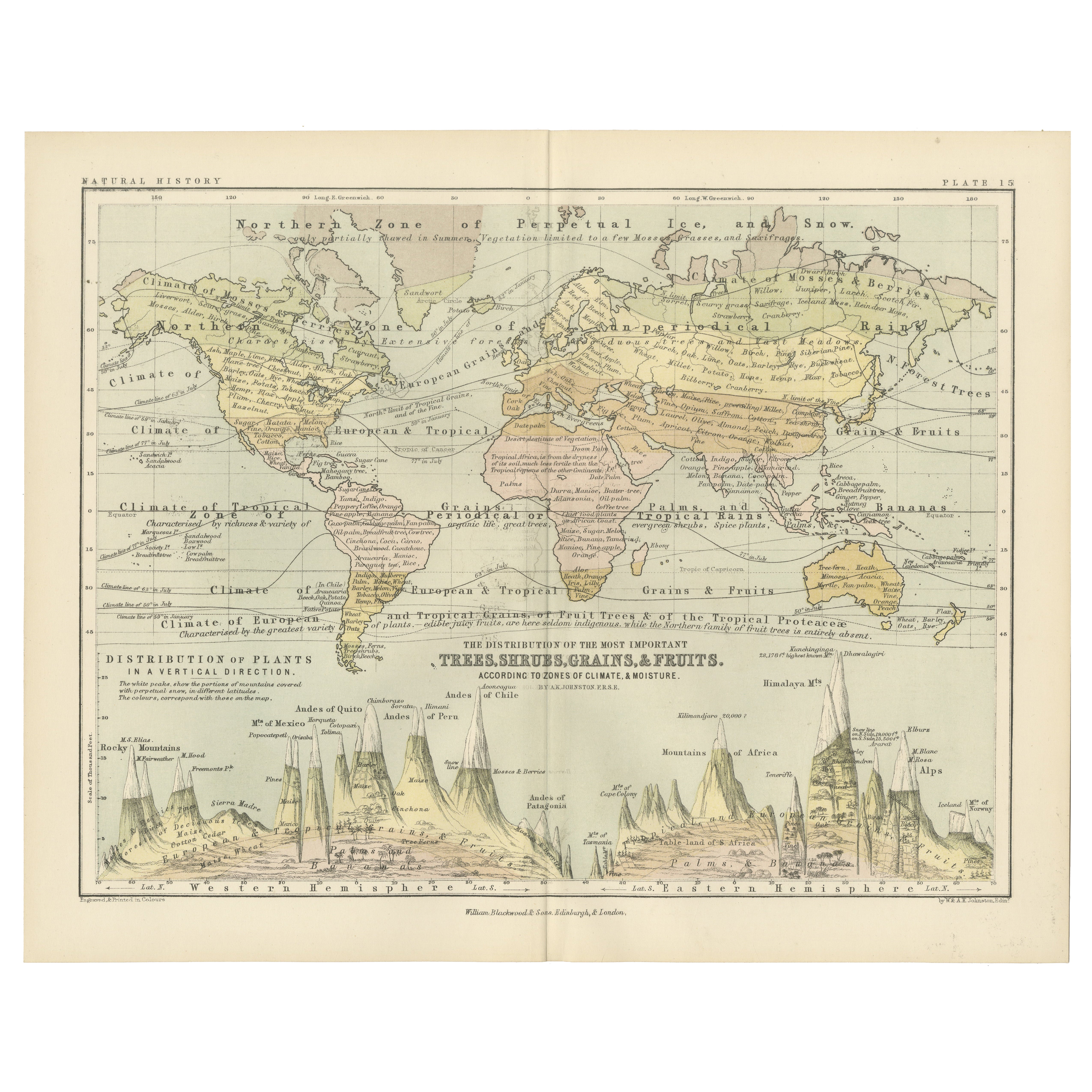
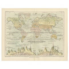
Botanical Map by A.K. Johnston – Global Plant Distribution Chart 1852
Botanical Map by A.K. Johnston – Global Plant Distribution Chart 1852
This remarkable antique chart titled "The Distribution of the Most Important Trees, Shrubs, Grains, & Fruits Ac...
Kategorie
Antik, Mittleres 19. Jahrhundert, Schottisch, Drucke
Materialien
Papier
Antike Karte mit der Darstellung der Abteilung und der Verteilung von Mammalen von Johnston aus dem Jahr 1850
Antike Karte mit dem Titel 'Geographische Einteilung und Verbreitung der Säugetiere der Ordnungen Quadrumana, Edentata, Marsupialia & Dickhäuter'. Originale antike Karte, die die geo...
Kategorie
Antik, Mittleres 19. Jahrhundert, Landkarten
Materialien
Papier
130 € Angebotspreis
35 % Rabatt
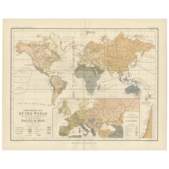
Ethnographic Map of the World by A.K. Johnston – Races of Man Chart 1852
Ethnographic Map of the World by A.K. Johnston – Races of Man Chart 1852
This antique map titled "Ethnographic Map of the World Showing the Present Distribution of the Leading Races...
Kategorie
Antik, Mittleres 19. Jahrhundert, Schottisch, Drucke
Materialien
Papier
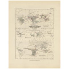
Antike zoologische und botanische Karte der Welt - Dekorative Karte, 1884
Antike zoologische und botanische Karten der Welt - Black's Atlas, 1884
Diese Doppeltafel aus der New and Revised Edition von Black's General Atlas of the World, die 1884 in Edinbur...
Kategorie
Antik, 1880er, Schottisch, Landkarten
Materialien
Papier
Das könnte Ihnen auch gefallen
Original antike Weltkarte von Dower, um 1835
Schöne Karte der Welt
Gezeichnet und gestochen von J. Dower
Herausgegeben von Orr & Smith. C.1835
Ungerahmt.
Kostenloser Versand
Kategorie
Antik, 1830er, Englisch, Landkarten
Materialien
Papier

Original illustrierte Planisphere von 1864 – Weltkarte – Geographie
Tauchen Sie ein in die epische Reise der Vergangenheit mit der Illustrierten Historischen Planisphäre von 1864 von Charpentier! 🗺️ Dieser kartografische Schatz entführt Sie in die F...
Kategorie
1860er, Druckgrafiken und Multiples
Materialien
Leinen, Lithografie, Papier

Original antike Originalkarte der Welt von Thomas Clerk, 1817
Große Karte der östlichen und westlichen Hemisphäre
Auf 2 Blättern
Kupferstich
Gezeichnet und gestochen von Thomas Clerk, Edinburgh.
Veröffentlicht von Mackenzie und Dent...
Kategorie
Antik, 1810er, Englisch, Landkarten
Materialien
Papier

Old British Empire Map – Antike Karte von Karl Spruner – 1760, ca.
Von Karl Spruner von Merz
Old British Empire Map ist ein um 1760 entstandenes Kunstwerk von Karl Spruner.
Original handkolorierter Druck.
Guter Zustand bis auf die Vergilbung des Papiers am Rand und einen k...
Kategorie
1760er, Moderne, Figurative Drucke
Materialien
Radierung

210 € Angebotspreis
25 % Rabatt
Große Original-Antike Originalkarte der Welt, Fullarton, um 1870
Großartige Karte der Welt. Zeigt beide Hemisphären
Aus dem berühmten Royal Illustrated Atlas
Lithografie. Originalfarbe.
Veröffentlicht von Fullarton, Edinburgh, um 1870
Ungerah...
Kategorie
Antik, 1870er, Schottisch, Landkarten
Materialien
Papier

Original antike Karte der östlichen Hemisphäre von Dower, um 1835
Schöne Karte der östlichen Hemisphäre
Gezeichnet und gestochen von J. Dower
Herausgegeben von Orr & Smith. C.1835
Ungerahmt.
Kostenloser Versand
Kategorie
Antik, 1830er, Englisch, Landkarten
Materialien
Papier
