Objekte ähnlich wie Climatological Map by A.K. Johnston – Global Temperatures Chart 1852


Möchten Sie mehr Bilder oder Videos?
Zusätzliche Bilder oder Videos von dem*der Anbieter*in anfordern
1 von 10
Climatological Map by A.K. Johnston – Global Temperatures Chart 1852
260 €pro Objekt|Einschließlich MwSt.
Menge
Angaben zum Objekt
Climatological Map by A.K. Johnston – Global Temperatures Chart 1852
This exceptional antique map titled "Climatological Chart Showing by Lines & Figures the Mean Annual Temperature of the Principal Places on the Globe" was created by Alexander Keith Johnston and published in 1852 by William Blackwood & Sons of Edinburgh and London. It was issued as Plate 12 in Johnston’s landmark *Physical Atlas of Natural Phenomena*, a pioneering 19th-century atlas that brought scientific visualization into wide public use.
This map is an early attempt to systematically present global climate data. It displays mean annual temperatures across the world using isothermal lines (red and blue) that connect locations of equal average temperature. The isotherms are drawn with precise geographic accuracy and overlaid with data from major cities and meteorological stations. The red lines represent mean annual temperatures at various latitudes, while blue lines denote temperature during winter.
The chart also includes two detailed insets. One shows the British Isles with a focus on summer and winter mean temperatures by city and station, while the second presents similar data for Central Europe. These regional maps offer insight into 19th-century meteorological science and the importance of regional climate comparisons in early climatology.
Johnston’s meticulous work combines data with elegant cartographic design. His maps are not only valuable scientific tools but also highly decorative. Johnston (1804–1871), Geographer in Ordinary to Queen Victoria in Scotland, was instrumental in the development of thematic cartography. His *Physical Atlas* remains one of the most influential scientific atlases ever published, appreciated for its beauty and clarity as much as for its content.
This plate is particularly interesting for its foresight in climate science and as an early visual reference to global temperature distribution—concepts that underpin today’s environmental studies and climate models.
Condition and framing tips:
Good condition with light age toning and minor wear at the margins. Image field clean and sharp. Frame in matte black or dark walnut with a cream or ivory mat to highlight the fine engraved lines and soft red and blue temperature curves. Ideal for scholars, educators, and interiors with a natural history or scientific theme.
- Maße:Höhe: 34,5 cm (13,59 in)Breite: 27,4 cm (10,79 in)Tiefe: 0,2 mm (0,01 in)
- Materialien und Methoden:
- Herkunftsort:
- Zeitalter:
- Herstellungsjahr:1852
- Zustand:Very good condition. Light overall toning near the margins. The paper remains strong and well-preserved. Folding line as issued.
- Anbieterstandort:Langweer, NL
- Referenznummer:Anbieter*in: BG-13207-121stDibs: LU3054345393422
Anbieterinformationen
5,0
Anerkannte Anbieter*innen
Diese renommierten Anbieter*innen sind führend in der Branche und repräsentieren die höchste Klasse in Sachen Qualität und Design.
Platin-Anbieter*in
Premium-Anbieter*innen mit einer Bewertung über 4,7 und 24 Stunden Reaktionszeit
Gründungsjahr 2009
1stDibs-Anbieter*in seit 2017
2.656 Verkäufe auf 1stDibs
Typische Antwortzeit: <1 Stunde
- VersandAngebot wird abgerufen …Versand von: Langweer, Niederlande
- Rückgabebedingungen
Einige Inhalte dieser Seite wurden automatisch übersetzt. Daher kann 1stDibs nicht die Richtigkeit der Übersetzungen garantieren. Englisch ist die Standardsprache dieser Website.
Authentizitätsgarantie
Im unwahrscheinlichen Fall eines Problems mit der Echtheit eines Objekts kontaktieren Sie uns bitte innerhalb von 1 Jahr für eine volle Rückerstattung. DetailsGeld-Zurück-Garantie
Wenn Ihr Objekt nicht der Beschreibung entspricht, beim Transport beschädigt wurde oder nicht ankommt, kontaktieren Sie uns bitte innerhalb von 7 Tagen für eine vollständige Rückerstattung. DetailsStornierung innerhalb von 24 Stunden
Sie können Ihren Kauf jederzeit innerhalb von 24 Stunden stornieren, ohne jegliche Gründe dafür angeben zu müssen.Geprüfte Anbieter*innen
Unsere Anbieter*innen unterliegen strengen Dienstleistungs- und Qualitätsstandards, wodurch wir die Seriosität unserer Angebote gewährleisten können.Preisgarantie
Wenn Sie feststellen, dass ein*e Anbieter*in dasselbe Objekt anderswo zu einem niedrigeren Preis anbietet, werden wir den Preis entsprechend anpassen.Zuverlässige weltweite Lieferung
Unsere erstklassigen Versandunternehmen bieten spezielle Versandoptionen weltweit, einschließlich individueller Lieferung.Mehr von diesem*dieser Anbieter*in
Alle anzeigenWind and Hurricane Map by A.K. Johnston – Meteorological Chart 1852
Wind and Hurricane Map by A.K. Johnston – Meteorological Chart 1852
This scientifically significant 1852 map titled "The Distribution of the Constant, Periodical & Variable Winds Ov...
Kategorie
Antik, Mittleres 19. Jahrhundert, Schottisch, Drucke
Materialien
Papier

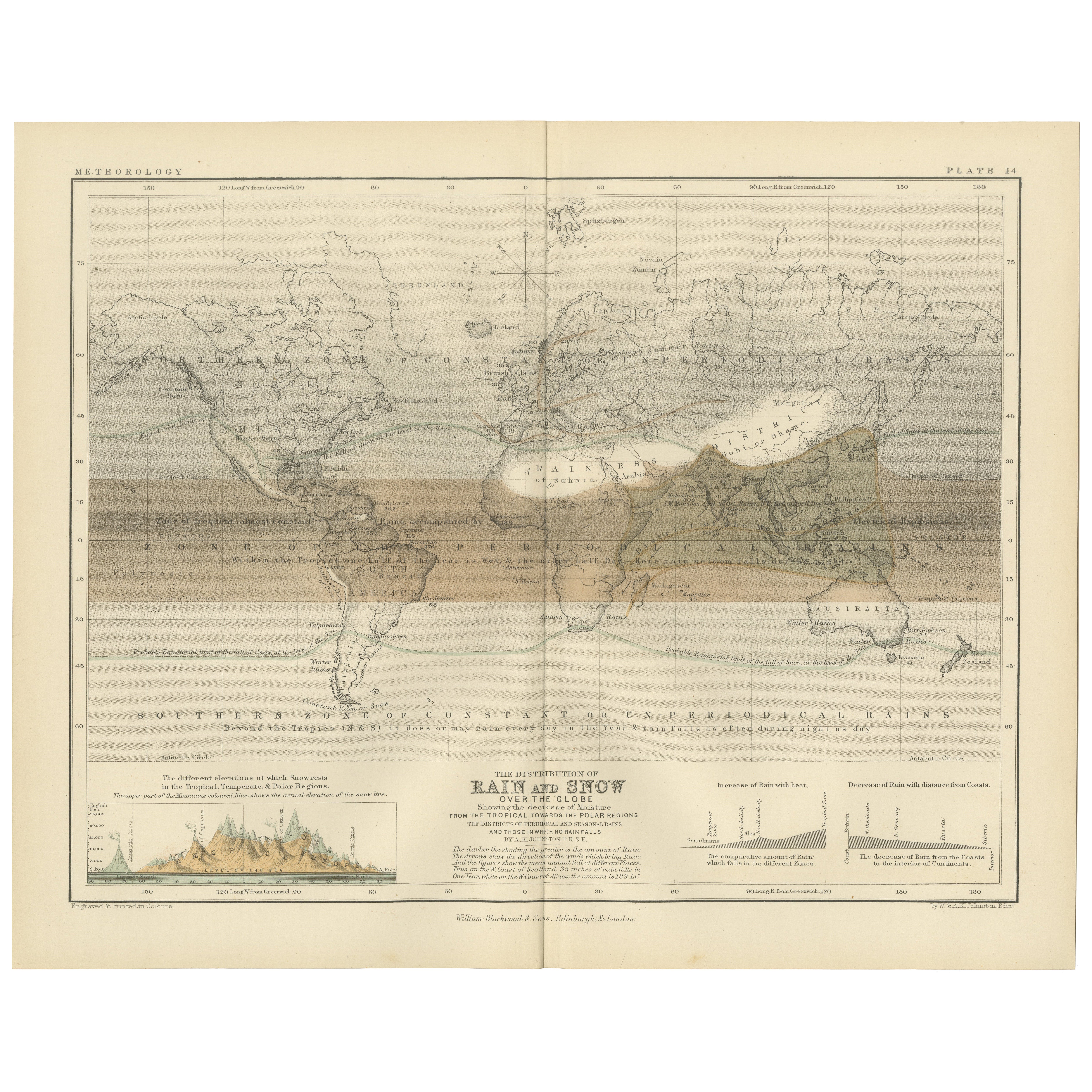
Rain and Snow Map by A.K. Johnston – Global Precipitation Chart 1852
Rain and Snow Map by A.K. Johnston – Global Precipitation Chart 1852
This antique meteorological chart titled "The Distribution of Rain and Snow over the Globe" was created by Alexa...
Kategorie
Antik, Mittleres 19. Jahrhundert, Schottisch, Drucke
Materialien
Papier
Antike Karte mit Isotherm-Linien auf der ganzen Welt von Johnston, um 1850
Antike Karte mit dem Titel 'Humboldt's System of Isothermal Lines'. Originale antike Karte mit Isothermenlinien in der ganzen Welt. Diese Karte stammt aus "The Physical Atlas of Natu...
Kategorie
Antik, Mittleres 19. Jahrhundert, Landkarten
Materialien
Papier

160 € Angebotspreis
20 % Rabatt
Antike Karte der Welt, die Verteilung von Pflanzen und Mineralien zeigt, 1872
Antike Karte mit dem Titel 'Johnson's World showing the distribution of the Characteristic Forest Trees (..)'. Original-Weltkarte, die die Verteilung von Pflanzen und Mineralien auf ...
Kategorie
Antik, Spätes 19. Jahrhundert, Landkarten
Materialien
Papier

160 € Angebotspreis
20 % Rabatt
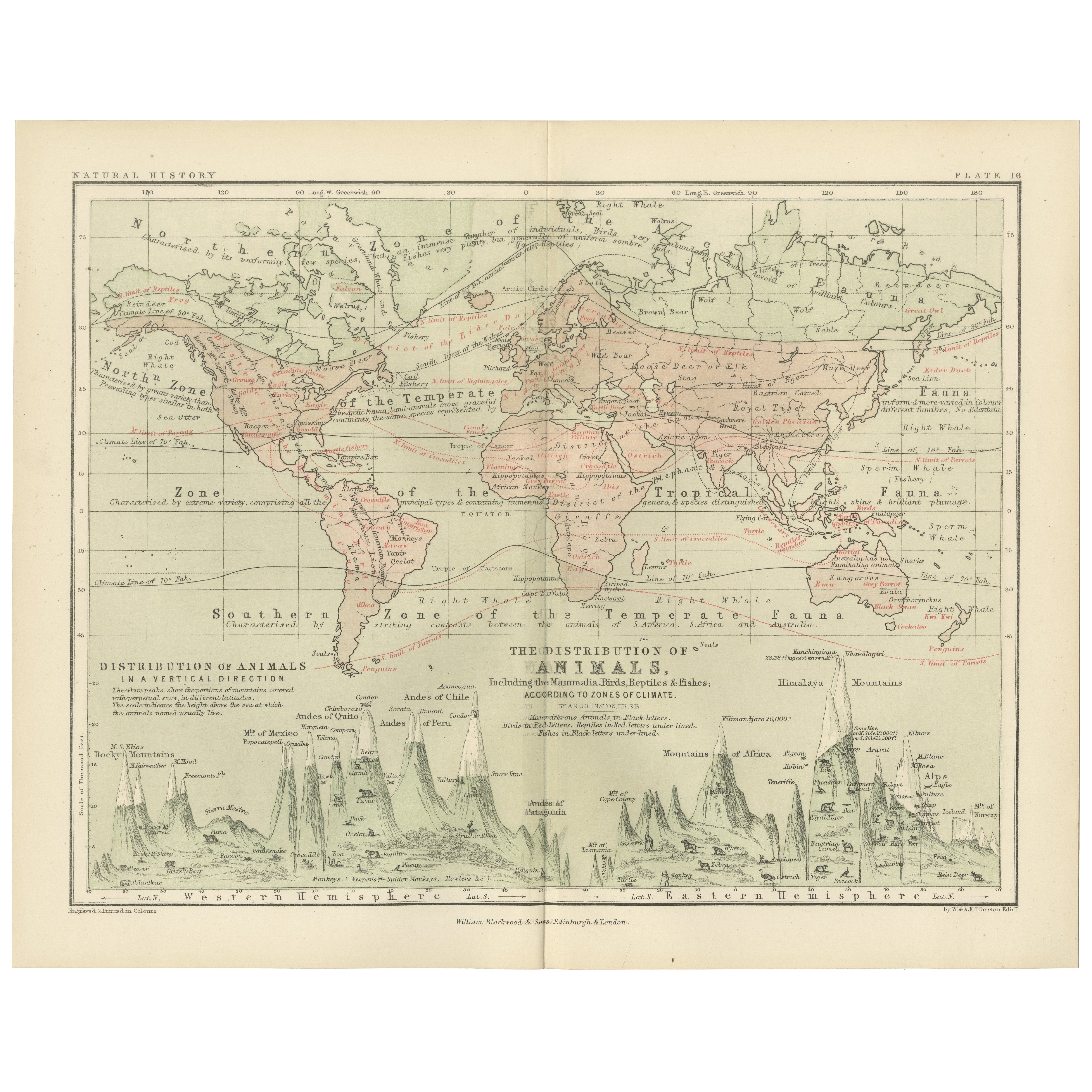
Animal Distribution Map by A.K. Johnston – Fauna by Climate Zones 1852
Animal Distribution Map by A.K. Johnston – Fauna by Climate Zones 1852
This beautifully engraved chart titled "The Distribution of Animals Including the Mammalia, Birds, Reptiles & ...
Kategorie
Antik, Mittleres 19. Jahrhundert, Schottisch, Drucke
Materialien
Papier
Antike Karte der Meeresströmungen und der Lufttemperatur, '1872'.
Zwei Karten auf einem Blatt mit den Titeln 'Johnson's Oceans Currents (..)' und 'Johnson's World showing the Distribution of the Temperature of the Air'. Original-Weltkarte mit Darst...
Kategorie
Antik, Spätes 19. Jahrhundert, Landkarten
Materialien
Papier

280 € Angebotspreis
20 % Rabatt
Das könnte Ihnen auch gefallen
Original antike Originalkarte der Welt von Thomas Clerk, 1817
Große Karte der östlichen und westlichen Hemisphäre
Auf 2 Blättern
Kupferstich
Gezeichnet und gestochen von Thomas Clerk, Edinburgh.
Veröffentlicht von Mackenzie und Dent...
Kategorie
Antik, 1810er, Englisch, Landkarten
Materialien
Papier

Original antike Karte der östlichen Hemisphäre von Dower, um 1835
Schöne Karte der östlichen Hemisphäre
Gezeichnet und gestochen von J. Dower
Herausgegeben von Orr & Smith. C.1835
Ungerahmt.
Kostenloser Versand
Kategorie
Antik, 1830er, Englisch, Landkarten
Materialien
Papier

Hemisphäre des Neuen Kontinents – Antike Karte von J.G. Heck - 1834.
Von Johann Georg Heck
Hemisphäre des neuen Kontinents ist ein um 1760 entstandenes Kunstwerk von Johann Georg Heck
Original-Farbdruck.
Guter Zustand mit Ausnahme der Vergilbung des Papiers und der Einrisse am Rand.
Originaltitel Hemisphere du Nouveau Continent et ses Antipodes. Gedruckt bei Engelmann & Compagnie, S.F., Paris.
Dieser Druck ist die Tafel Nr. 7 aus "Atlas geographique, astronomique et historique, servant a l'intelligence de l'histoire ancienne, du moyen age et moderne et a la lecture des voyages les plus recens. Dresse d'apres les meilleurs materiaux tant francais qu'etrangers conformement aus progres de la science, par J.G. Mist."
Johann Georg Heck (1795 - 1857) war ein deutscher Buchhändler...
Kategorie
1830er, Moderne, Figurative Drucke
Materialien
Radierung

487 € Angebotspreis
25 % Rabatt
Original antike Weltkarte von Dower, um 1835
Schöne Karte der Welt
Gezeichnet und gestochen von J. Dower
Herausgegeben von Orr & Smith. C.1835
Ungerahmt.
Kostenloser Versand
Kategorie
Antik, 1830er, Englisch, Landkarten
Materialien
Papier

Original Antike Karte der westlichen Hemisphäre von Dower, circa 1835
Schöne Karte der westlichen Hemisphäre
Gezeichnet und gestochen von J. Dower
Herausgegeben von Orr & Smith. C.1835
Ungerahmt.
Kostenloser Versand
Kategorie
Antik, 1830er, Englisch, Landkarten
Materialien
Papier

Old British Empire Map – Antike Karte von Karl Spruner – 1760, ca.
Von Karl Spruner von Merz
Old British Empire Map ist ein um 1760 entstandenes Kunstwerk von Karl Spruner.
Original handkolorierter Druck.
Guter Zustand bis auf die Vergilbung des Papiers am Rand und einen k...
Kategorie
1760er, Moderne, Figurative Drucke
Materialien
Radierung

210 € Angebotspreis
25 % Rabatt