Objekte ähnlich wie Ethnographic Map of the World by A.K. Johnston – Races of Man Chart 1852


Möchten Sie mehr Bilder oder Videos?
Zusätzliche Bilder oder Videos von dem*der Anbieter*in anfordern
1 von 10
Ethnographic Map of the World by A.K. Johnston – Races of Man Chart 1852
260 €pro Objekt|Einschließlich MwSt.
Menge
Angaben zum Objekt
Ethnographic Map of the World by A.K. Johnston – Races of Man Chart 1852
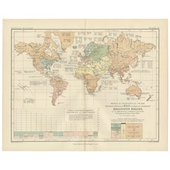
This antique map titled "Ethnographic Map of the World Showing the Present Distribution of the Leading Races of Man" was created by Alexander Keith Johnston and published in 1852 by William Blackwood & Sons in Edinburgh and London. Issued as Plate 17 in Johnston’s *Physical Atlas of Natural Phenomena*, this map reflects 19th-century efforts to visualize human diversity across the globe through early ethnographic theory.
The map categorizes the world's populations into ten generalized racial and cultural groupings, each represented in distinct pastel shades. These include classifications such as Indo-European, Semitic, Negro, Mongolian, Malay, American, and others based on contemporary (now outdated) 19th-century anthropological thought. The regions of distribution are shaded accordingly, spanning continents from the Arctic Circle to the islands of the Pacific.
A large inset map at the bottom right provides a focused view of Europe, showing greater detail in the distribution of groups such as Slavonic, Germanic, Celtic, Basque, and Finnic peoples. Alongside it is a striking profile diagram illustrating the elevation of Earth's landmasses, tying physical geography to patterns of human settlement.
This map, like many from the mid-19th century, combines the empirical ambitions of early anthropology with the visual clarity of scientific cartography. While its categories and terminology are now considered outdated and oversimplified, the chart is an important artifact from the history of ethnography and reflects the European scientific worldview of the time.
Alexander Keith Johnston (1804–1871), one of the most respected geographers of his age, created the *Physical Atlas* as an educational tool to help readers understand the natural world and its human patterns through maps. His work remains a landmark in the development of thematic cartography.
This plate is a compelling object for collectors of antique maps, anthropology history, or Victorian educational materials, and is often studied for its role in the evolution of ethnographic science.
Condition and framing tips:
Very good condition with minimal age toning and a clean printed surface. Centerfold as issued. Frame in black or dark oak wood with a neutral ivory or parchment mat to complement the subdued palette and historic typography. Suitable for a library, academic office, or collection of early scientific prints.
- Maße:Höhe: 27,4 cm (10,79 in)Breite: 34,5 cm (13,59 in)Tiefe: 0,2 mm (0,01 in)
- Materialien und Methoden:
- Herkunftsort:
- Zeitalter:
- Herstellungsjahr:1852
- Zustand:Very good condition. Light overall toning near the margins and some offset over Europe. The paper remains strong and well-preserved. Folding line as issued.
- Anbieterstandort:Langweer, NL
- Referenznummer:Anbieter*in: BG-13207-171stDibs: LU3054345393552
Anbieterinformationen
5,0
Anerkannte Anbieter*innen
Diese renommierten Anbieter*innen sind führend in der Branche und repräsentieren die höchste Klasse in Sachen Qualität und Design.
Platin-Anbieter*in
Premium-Anbieter*innen mit einer Bewertung über 4,7 und 24 Stunden Reaktionszeit
Gründungsjahr 2009
1stDibs-Anbieter*in seit 2017
2.656 Verkäufe auf 1stDibs
Typische Antwortzeit: <1 Stunde
- VersandAngebot wird abgerufen …Versand von: Langweer, Niederlande
- Rückgabebedingungen
Einige Inhalte dieser Seite wurden automatisch übersetzt. Daher kann 1stDibs nicht die Richtigkeit der Übersetzungen garantieren. Englisch ist die Standardsprache dieser Website.
Authentizitätsgarantie
Im unwahrscheinlichen Fall eines Problems mit der Echtheit eines Objekts kontaktieren Sie uns bitte innerhalb von 1 Jahr für eine volle Rückerstattung. DetailsGeld-Zurück-Garantie
Wenn Ihr Objekt nicht der Beschreibung entspricht, beim Transport beschädigt wurde oder nicht ankommt, kontaktieren Sie uns bitte innerhalb von 7 Tagen für eine vollständige Rückerstattung. DetailsStornierung innerhalb von 24 Stunden
Sie können Ihren Kauf jederzeit innerhalb von 24 Stunden stornieren, ohne jegliche Gründe dafür angeben zu müssen.Geprüfte Anbieter*innen
Unsere Anbieter*innen unterliegen strengen Dienstleistungs- und Qualitätsstandards, wodurch wir die Seriosität unserer Angebote gewährleisten können.Preisgarantie
Wenn Sie feststellen, dass ein*e Anbieter*in dasselbe Objekt anderswo zu einem niedrigeren Preis anbietet, werden wir den Preis entsprechend anpassen.Zuverlässige weltweite Lieferung
Unsere erstklassigen Versandunternehmen bieten spezielle Versandoptionen weltweit, einschließlich individueller Lieferung.Mehr von diesem*dieser Anbieter*in
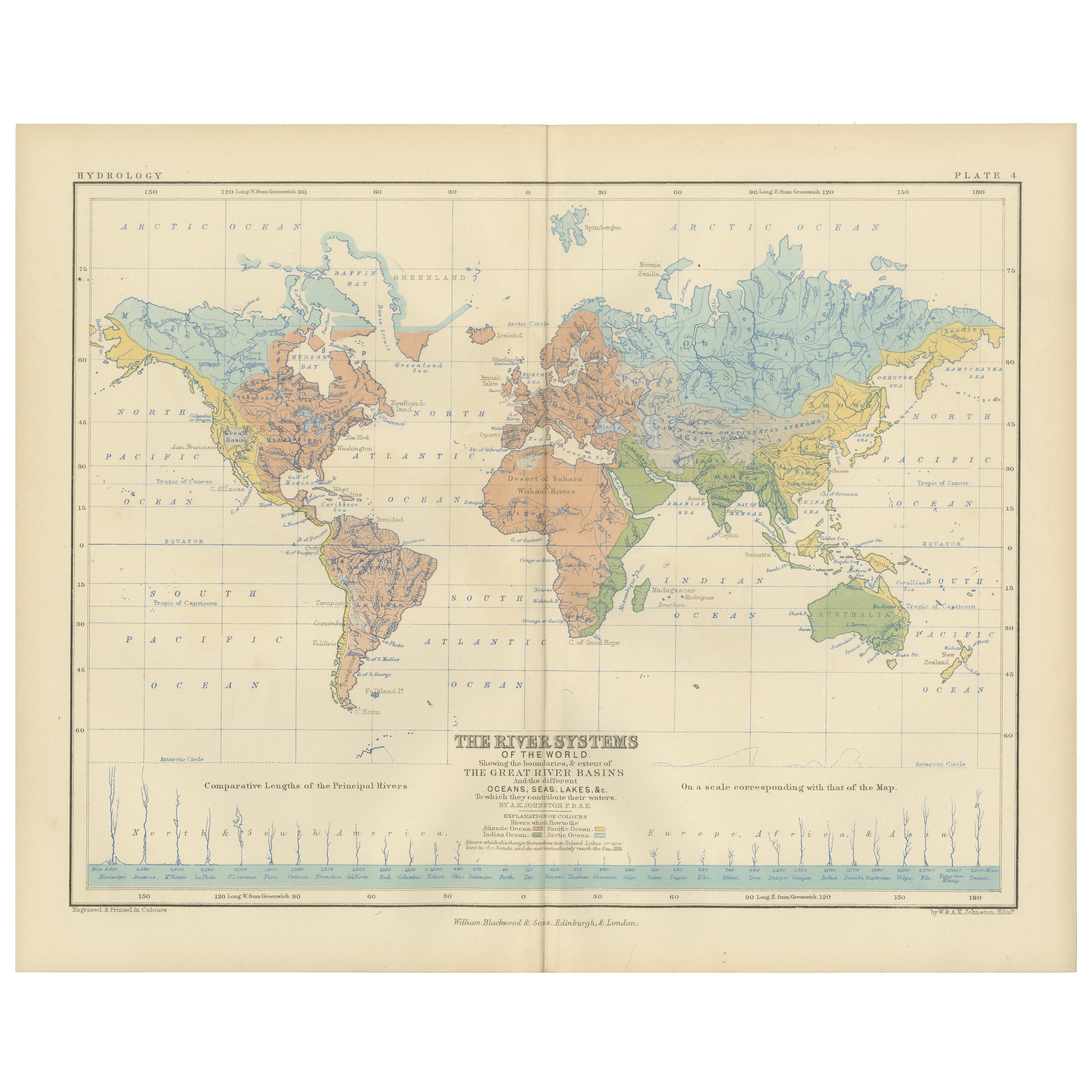
Alle anzeigenRiver Systems Map of the World by A.K. Johnston – Educational Print 1852
River Systems Map of the World by A.K. Johnston – Educational Print 1852
This striking 1852 map titled "The River Systems of the World" was created by the noted Scottish geographer ...
Kategorie
Antik, Mittleres 19. Jahrhundert, Schottisch, Drucke
Materialien
Papier

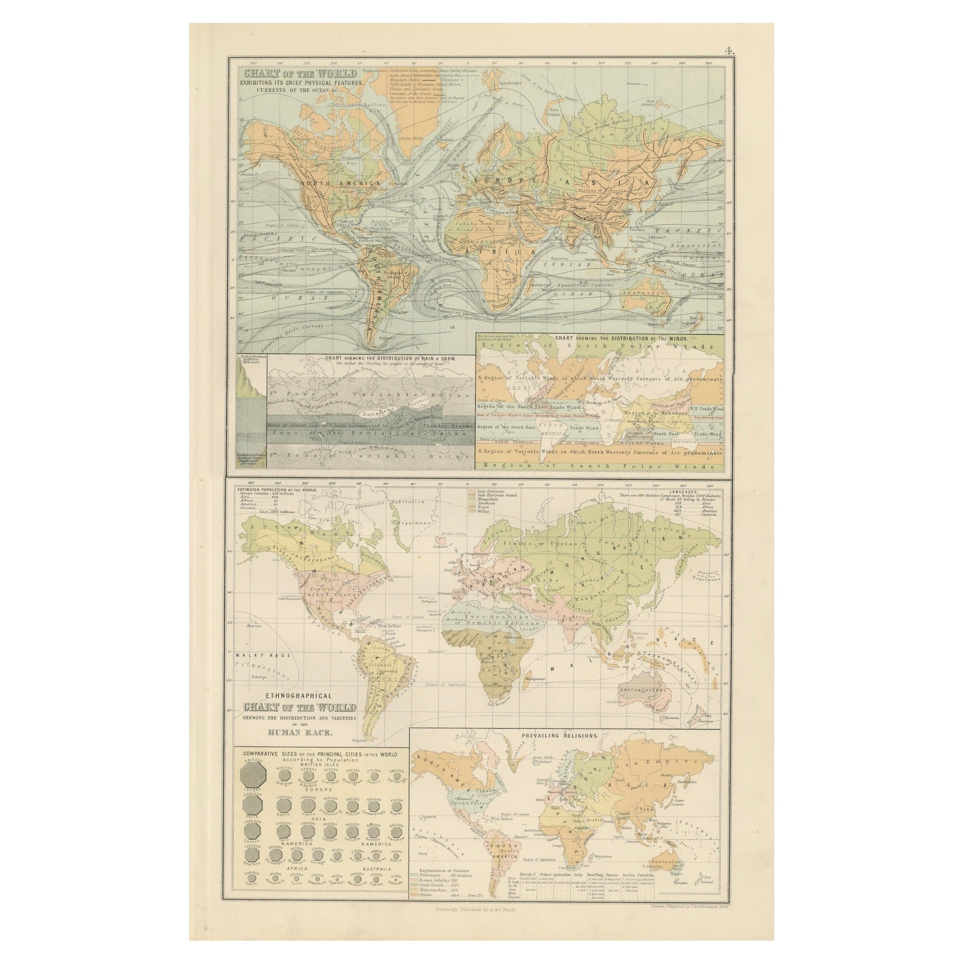
Antike Weltkarte - Physikalische Merkmale und ethnographische Karte, 1884
Antike Weltkarte - Physikalische Merkmale und ethnographische Karte, 1884
Beschreibung:
Diese faszinierende Doppeltafel aus der New and Revised Edition von Black's General Atlas of ...
Kategorie
Antik, 1880er, Schottisch, Landkarten
Materialien
Papier
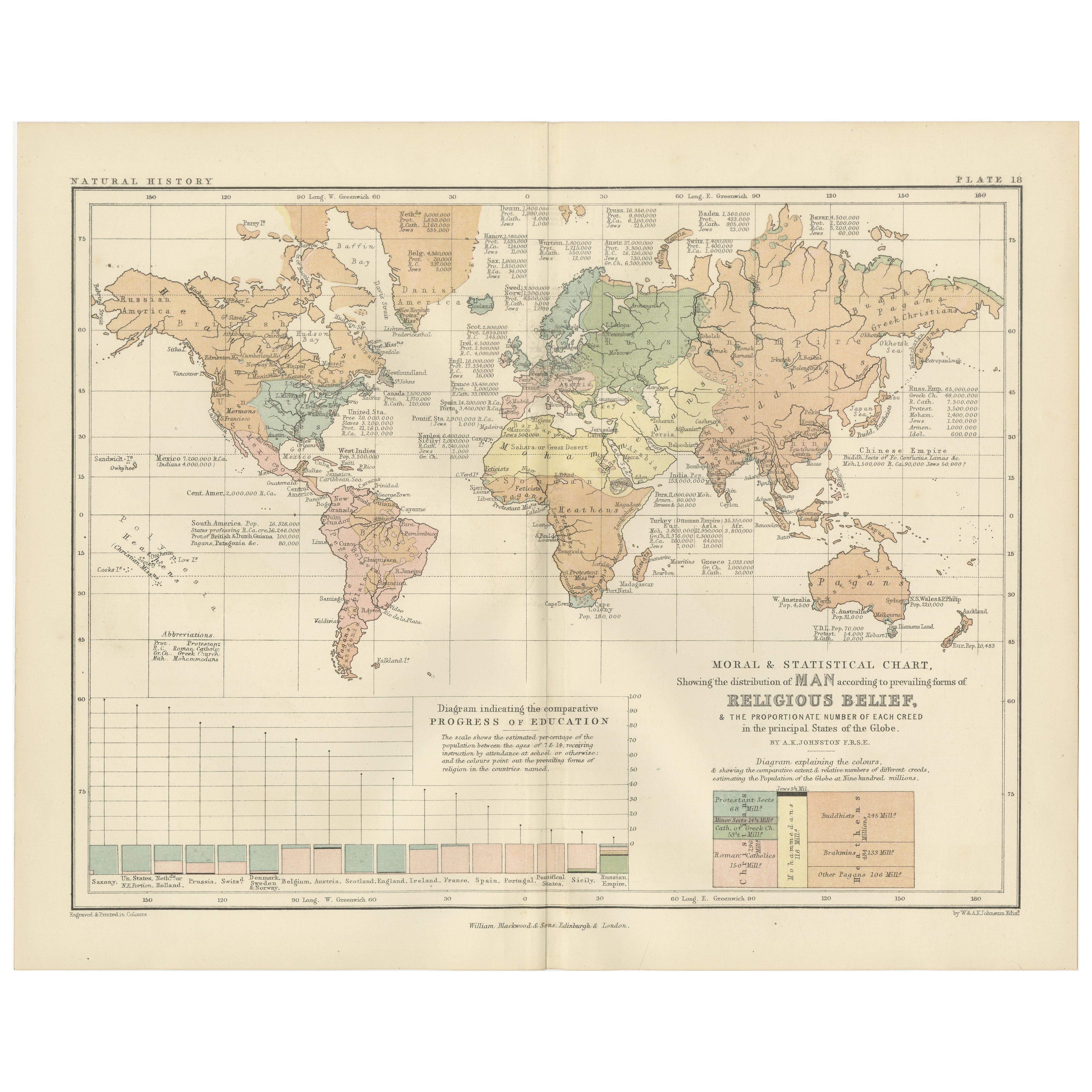
Antike antike Karte, die Religionen um die Welt zeigt, von Johnston '1854'
Antike Karte mit dem Titel "Moralische und statistische Darstellung der geografischen Verteilung der Menschen nach religiöser Zugehörigkeit". Seltene großformatige thematische Karte ...
Kategorie
Antik, Mittleres 19. Jahrhundert, Landkarten
Materialien
Papier

780 € Angebotspreis
35 % Rabatt
Religious Belief Map by A.K. Johnston – Moral and Statistical Chart 1852
Religious Belief Map by A.K. Johnston – Moral and Statistical Chart 1852
This antique chart titled "Moral & Statistical Chart Showing the Distribution of Man According to Prevailing...
Kategorie
Antik, Mittleres 19. Jahrhundert, Schottisch, Drucke
Materialien
Papier
Antike Karte der Welt, die Verteilung von Pflanzen und Mineralien zeigt, 1872
Antike Karte mit dem Titel 'Johnson's World showing the distribution of the Characteristic Forest Trees (..)'. Original-Weltkarte, die die Verteilung von Pflanzen und Mineralien auf ...
Kategorie
Antik, Spätes 19. Jahrhundert, Landkarten
Materialien
Papier

160 € Angebotspreis
20 % Rabatt
Antike Karte mit der Darstellung der Abteilung und der Verteilung von Mammalen von Johnston aus dem Jahr 1850
Antike Karte mit dem Titel "Geografische Einteilung und Verbreitung der Säugetiere der Ordnungen Rodentia und Ruminantia über den Globus". Originale antike Karte mit der geografische...
Kategorie
Antik, Mittleres 19. Jahrhundert, Landkarten
Materialien
Papier

160 € Angebotspreis
20 % Rabatt
Das könnte Ihnen auch gefallen
Original antike Weltkarte von Dower, um 1835
Schöne Karte der Welt
Gezeichnet und gestochen von J. Dower
Herausgegeben von Orr & Smith. C.1835
Ungerahmt.
Kostenloser Versand
Kategorie
Antik, 1830er, Englisch, Landkarten
Materialien
Papier

Original illustrierte Planisphere von 1864 – Weltkarte – Geographie
Tauchen Sie ein in die epische Reise der Vergangenheit mit der Illustrierten Historischen Planisphäre von 1864 von Charpentier! 🗺️ Dieser kartografische Schatz entführt Sie in die F...
Kategorie
1860er, Druckgrafiken und Multiples
Materialien
Leinen, Lithografie, Papier

Old British Empire Map – Antike Karte von Karl Spruner – 1760, ca.
Von Karl Spruner von Merz
Old British Empire Map ist ein um 1760 entstandenes Kunstwerk von Karl Spruner.
Original handkolorierter Druck.
Guter Zustand bis auf die Vergilbung des Papiers am Rand und einen k...
Kategorie
1760er, Moderne, Figurative Drucke
Materialien
Radierung

210 € Angebotspreis
25 % Rabatt
Karte der Welt – Original-Radierung – 1820
Die Weltkarte ist eine Original-Radierung eines unbekannten Künstlers des 19. Jahrhunderts aus dem Jahr 1820.
Sehr guter Zustand auf zwei in der Mitte verbundenen weißen Blättern.
...
Kategorie
1820er, Moderne, Figurative Drucke
Materialien
Radierung

Antike Karte der östlichen Hemisphäre aus der Sammlung von Thierry Despont
Entworfen von Enrico Bonetti (E. Bonatti) und herausgegeben von Francesco Vallardi Editore. Auf der Grundlage einer früheren Karte von Evangelista Azzi (Ev. Azzi). Am unteren Rand de...
Kategorie
Antik, Spätes 19. Jahrhundert, Italienisch, Landkarten
Materialien
Leinwand, Holz

Original antike Originalkarte der Welt von Thomas Clerk, 1817
Große Karte der östlichen und westlichen Hemisphäre
Auf 2 Blättern
Kupferstich
Gezeichnet und gestochen von Thomas Clerk, Edinburgh.
Veröffentlicht von Mackenzie und Dent...
Kategorie
Antik, 1810er, Englisch, Landkarten
Materialien
Papier
