Objekte ähnlich wie River Systems Map of the World by A.K. Johnston – Educational Print 1852


Möchten Sie mehr Bilder oder Videos?
Zusätzliche Bilder oder Videos von dem*der Anbieter*in anfordern
1 von 10
River Systems Map of the World by A.K. Johnston – Educational Print 1852
260 €pro Objekt|Einschließlich MwSt.
Menge
Angaben zum Objekt
River Systems Map of the World by A.K. Johnston – Educational Print 1852
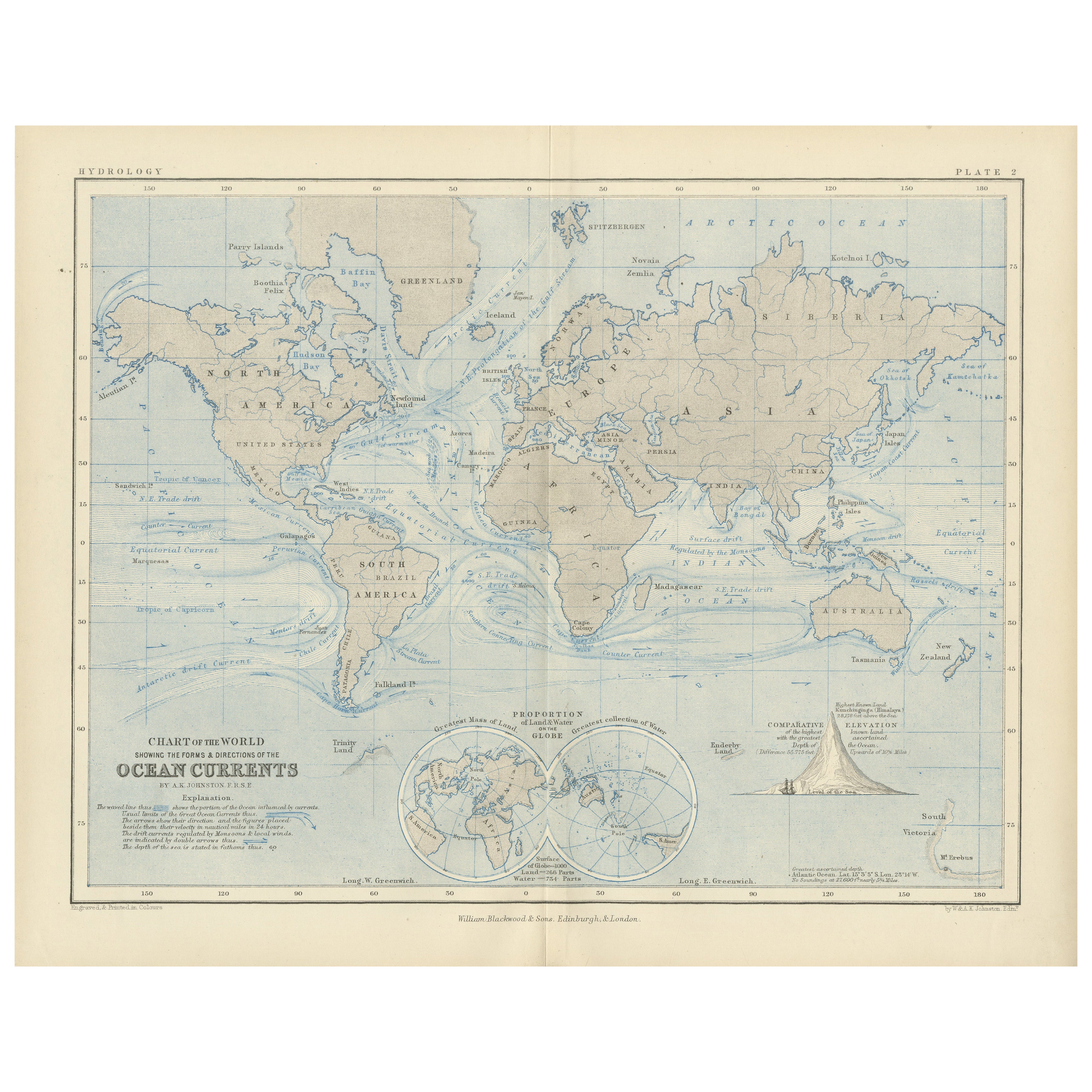
This striking 1852 map titled "The River Systems of the World" was created by the noted Scottish geographer Alexander Keith Johnston and published by William Blackwood & Sons in Edinburgh and London. It is Plate 4 from Johnston’s groundbreaking work *The Physical Atlas of Natural Phenomena*, a pioneering example of thematic cartography that visually communicates scientific data on a global scale.
This hand-colored copperplate engraving displays the world’s major river basins, categorized by color to represent the direction of river drainage toward different oceans and inland basins. Each continental landmass is divided by watershed, visually illustrating how rivers flow to the Atlantic, Pacific, Indian, Arctic Oceans, or into interior lakes and deserts. For instance, blue shows drainage toward the Arctic Ocean, brown for the Atlantic, green for the Indian Ocean, and so forth. The result is a vividly segmented and scientifically meaningful depiction of Earth's hydrological patterns.
A fascinating feature of the print is the comparative diagram running along the bottom, showing the relative lengths of the world’s principal rivers such as the Amazon, Nile, Mississippi, Yangtze, and Volga. This allows the viewer to grasp the scale and hierarchy of global river systems at a glance.
Johnston, who served as Geographer in Ordinary to Queen Victoria in Scotland, was renowned for his clarity, precision, and ability to synthesize scientific knowledge into accessible graphic forms. His *Physical Atlas* was one of the first atlases to present natural phenomena using maps rather than text alone, making it a cornerstone of modern data visualization.
This particular map is of special interest to collectors, educators, and designers for its combination of scientific accuracy and striking color composition. It appeals to those interested in geography, environmental science, and historical education, while also offering decorative appeal through its classic layout and 19th-century color palette.
Condition and framing tips:
Very good antique condition with some mild toning and occasional foxing in the margins. The printed area is clean and well-preserved. For framing, a walnut or black frame with a warm cream or ivory mat will bring out the map’s subtle hand-coloring. Pale blue or light earth-toned mats also work well to echo the map’s thematic hues. Ideal for display in a study, library, or educational setting.
- Maße:Höhe: 27,4 cm (10,79 in)Breite: 34,5 cm (13,59 in)Tiefe: 0,2 mm (0,01 in)
- Materialien und Methoden:
- Herkunftsort:
- Zeitalter:
- Herstellungsjahr:1856
- Zustand:Very good condition. Light overall toning near the margins. The paper remains strong and well-preserved. Folding line as issued.
- Anbieterstandort:Langweer, NL
- Referenznummer:Anbieter*in: BG-13207-41stDibs: LU3054345385942
Anbieterinformationen
5,0
Anerkannte Anbieter*innen
Diese renommierten Anbieter*innen sind führend in der Branche und repräsentieren die höchste Klasse in Sachen Qualität und Design.
Platin-Anbieter*in
Premium-Anbieter*innen mit einer Bewertung über 4,7 und 24 Stunden Reaktionszeit
Gründungsjahr 2009
1stDibs-Anbieter*in seit 2017
2.658 Verkäufe auf 1stDibs
Typische Antwortzeit: <1 Stunde
- VersandAngebot wird abgerufen …Versand von: Langweer, Niederlande
- Rückgabebedingungen
Einige Inhalte dieser Seite wurden automatisch übersetzt. Daher kann 1stDibs nicht die Richtigkeit der Übersetzungen garantieren. Englisch ist die Standardsprache dieser Website.
Authentizitätsgarantie
Im unwahrscheinlichen Fall eines Problems mit der Echtheit eines Objekts kontaktieren Sie uns bitte innerhalb von 1 Jahr für eine volle Rückerstattung. DetailsGeld-Zurück-Garantie
Wenn Ihr Objekt nicht der Beschreibung entspricht, beim Transport beschädigt wurde oder nicht ankommt, kontaktieren Sie uns bitte innerhalb von 7 Tagen für eine vollständige Rückerstattung. DetailsStornierung innerhalb von 24 Stunden
Sie können Ihren Kauf jederzeit innerhalb von 24 Stunden stornieren, ohne jegliche Gründe dafür angeben zu müssen.Geprüfte Anbieter*innen
Unsere Anbieter*innen unterliegen strengen Dienstleistungs- und Qualitätsstandards, wodurch wir die Seriosität unserer Angebote gewährleisten können.Preisgarantie
Wenn Sie feststellen, dass ein*e Anbieter*in dasselbe Objekt anderswo zu einem niedrigeren Preis anbietet, werden wir den Preis entsprechend anpassen.Zuverlässige weltweite Lieferung
Unsere erstklassigen Versandunternehmen bieten spezielle Versandoptionen weltweit, einschließlich individueller Lieferung.Mehr von diesem*dieser Anbieter*in
Alle anzeigenEthnographic Map of the World by A.K. Johnston – Races of Man Chart 1852
Ethnographic Map of the World by A.K. Johnston – Races of Man Chart 1852
This antique map titled "Ethnographic Map of the World Showing the Present Distribution of the Leading Races...
Kategorie
Antik, Mittleres 19. Jahrhundert, Schottisch, Drucke
Materialien
Papier
Antike Karte der Flusssysteme Europas und Asien von Johnston '1850'
Antike Karte mit dem Titel "Die Flusssysteme Europas und Asiens mit den Grenzen und der vergleichenden Ausdehnung der Flusseinzugsgebiete". Original antike Karte der Flusssysteme Eur...
Kategorie
Antik, Mittleres 19. Jahrhundert, Landkarten
Materialien
Papier

160 € Angebotspreis
20 % Rabatt
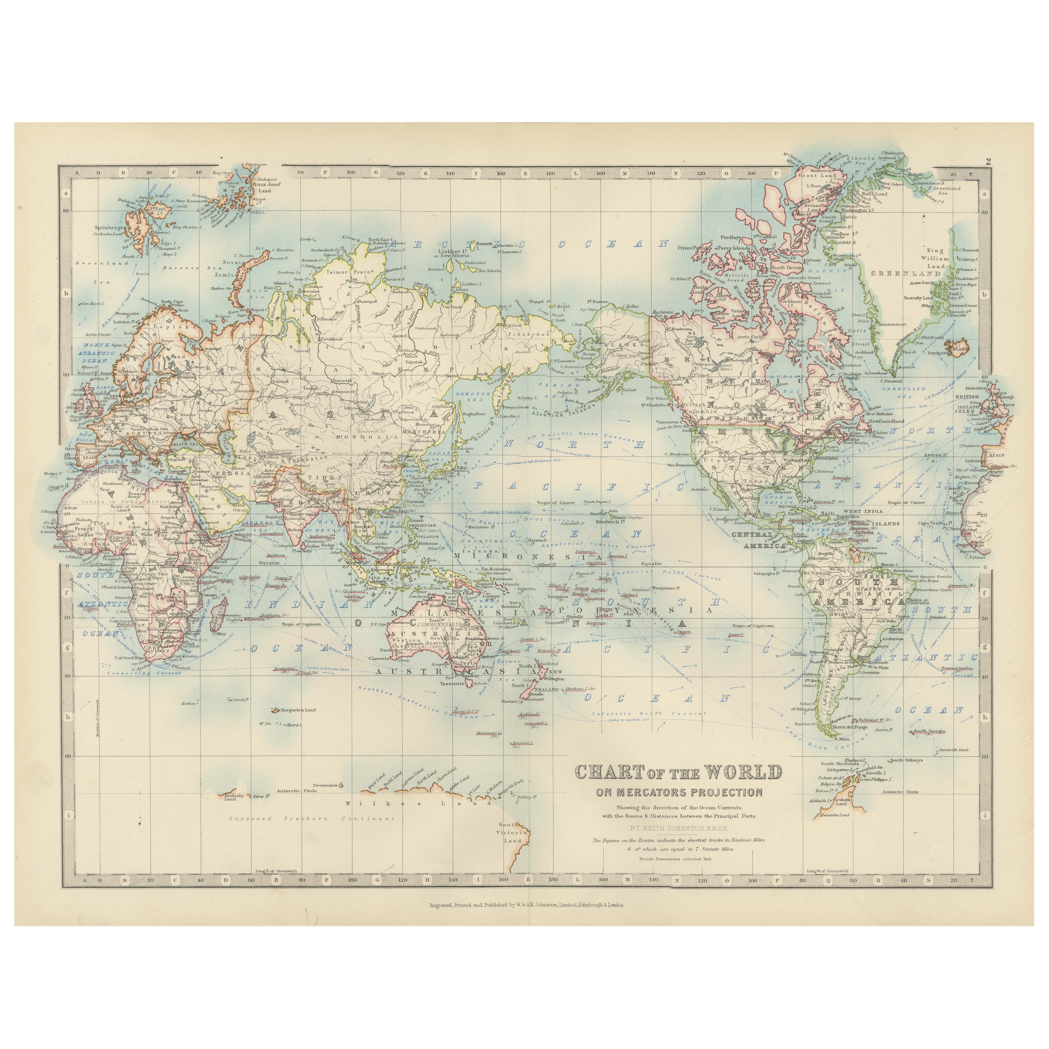
Antike Weltkarte auf Mercator-Projektion, Meeresströmungen und Handelsrouten 1903
Titel: Antike Weltkarte auf Mercator-Projektion, 1903, mit Darstellung der Meeresströmungen und Handelswege
Beschreibung:
Diese antike Karte mit dem Titel "Chart of the World on Mer...
Kategorie
Frühes 20. Jahrhundert, Landkarten
Materialien
Papier

Antike antike Karte, die Religionen um die Welt zeigt, von Johnston '1854'
Antike Karte mit dem Titel "Moralische und statistische Darstellung der geografischen Verteilung der Menschen nach religiöser Zugehörigkeit". Seltene großformatige thematische Karte ...
Kategorie
Antik, Mittleres 19. Jahrhundert, Landkarten
Materialien
Papier

780 € Angebotspreis
35 % Rabatt
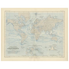
World Map of Ocean Currents by A.K. Johnston, Educational Print 1852
World Map of Ocean Currents by A.K. Johnston, Educational Print 1852
This detailed and scientifically rich chart titled 'Chart of the World Showing the Form & Direction of the Ocean...
Kategorie
Antik, Mittleres 19. Jahrhundert, Schottisch, Drucke
Materialien
Papier
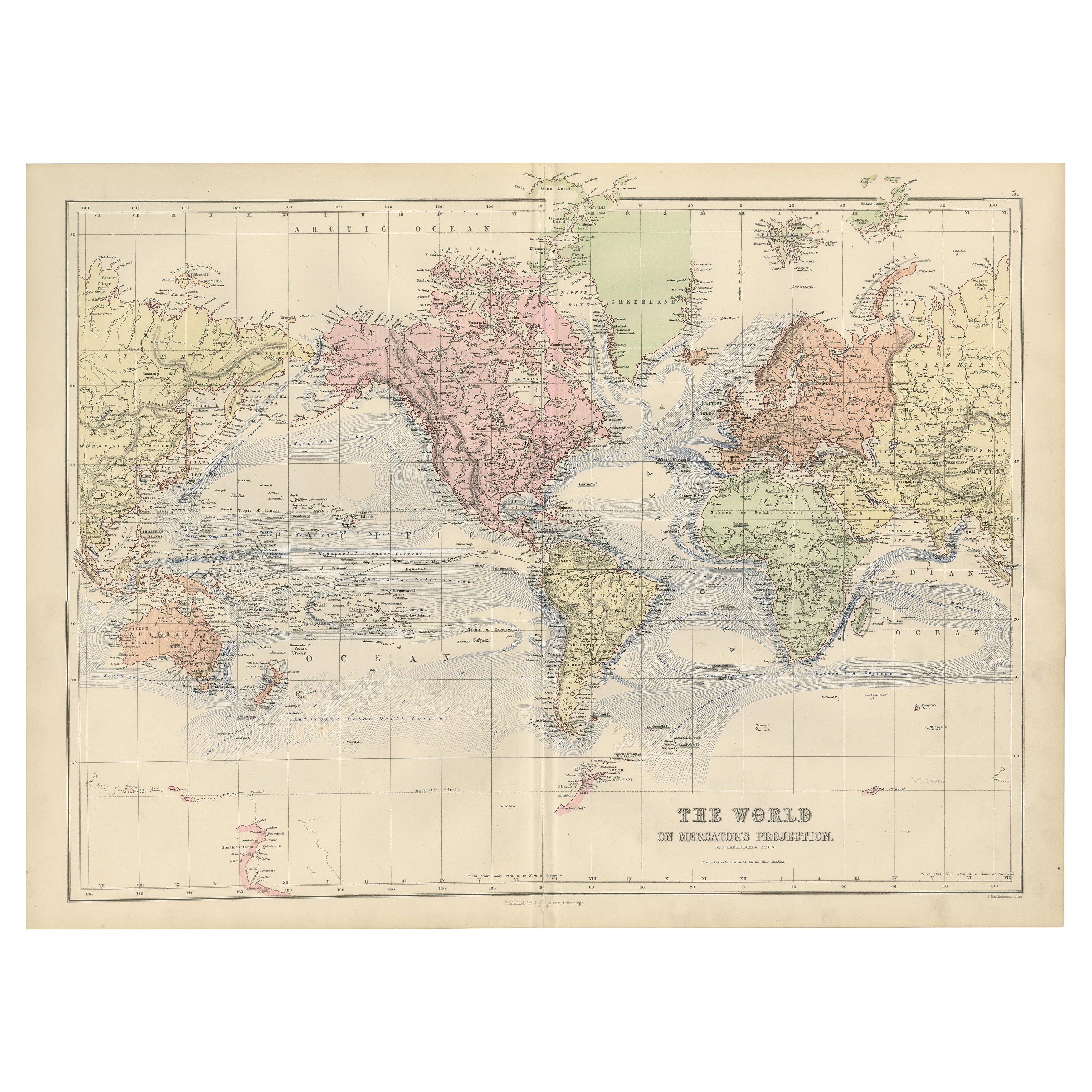
1884 Antike dekorative Weltkarte - Mercator Projektion, viktorianische Epoche Druck
Antike Weltkarte auf Mercator-Projektion - Black's Atlas, 1884
Diese fein gestochene und kolorierte Karte mit dem Titel The World on Mercator's Projection wurde in der New and Revis...
Kategorie
Antik, 1880er, Schottisch, Landkarten
Materialien
Papier

Das könnte Ihnen auch gefallen
Original antike Weltkarte von Dower, um 1835
Schöne Karte der Welt
Gezeichnet und gestochen von J. Dower
Herausgegeben von Orr & Smith. C.1835
Ungerahmt.
Kostenloser Versand
Kategorie
Antik, 1830er, Englisch, Landkarten
Materialien
Papier

Original illustrierte Planisphere von 1864 – Weltkarte – Geographie
Tauchen Sie ein in die epische Reise der Vergangenheit mit der Illustrierten Historischen Planisphäre von 1864 von Charpentier! 🗺️ Dieser kartografische Schatz entführt Sie in die F...
Kategorie
1860er, Druckgrafiken und Multiples
Materialien
Leinen, Lithografie, Papier

Große Original-Antike Originalkarte der Welt, Fullarton, um 1870
Großartige Karte der Welt. Zeigt beide Hemisphären
Aus dem berühmten Royal Illustrated Atlas
Lithografie. Originalfarbe.
Veröffentlicht von Fullarton, Edinburgh, um 1870
Ungerah...
Kategorie
Antik, 1870er, Schottisch, Landkarten
Materialien
Papier

Original Antike Karte der westlichen Hemisphäre von Dower, circa 1835
Schöne Karte der westlichen Hemisphäre
Gezeichnet und gestochen von J. Dower
Herausgegeben von Orr & Smith. C.1835
Ungerahmt.
Kostenloser Versand
Kategorie
Antik, 1830er, Englisch, Landkarten
Materialien
Papier

Karte der Welt – Original-Radierung – 1820
Die Weltkarte ist eine Original-Radierung eines unbekannten Künstlers des 19. Jahrhunderts aus dem Jahr 1820.
Sehr guter Zustand auf zwei in der Mitte verbundenen weißen Blättern.
...
Kategorie
1820er, Moderne, Figurative Drucke
Materialien
Radierung

Original antike Karte der östlichen Hemisphäre von Dower, um 1835
Schöne Karte der östlichen Hemisphäre
Gezeichnet und gestochen von J. Dower
Herausgegeben von Orr & Smith. C.1835
Ungerahmt.
Kostenloser Versand
Kategorie
Antik, 1830er, Englisch, Landkarten
Materialien
Papier
