Objekte ähnlich wie Wind and Hurricane Map by A.K. Johnston – Meteorological Chart 1852


Möchten Sie mehr Bilder oder Videos?
Zusätzliche Bilder oder Videos von dem*der Anbieter*in anfordern
1 von 10
Wind and Hurricane Map by A.K. Johnston – Meteorological Chart 1852
260 €pro Objekt|Einschließlich MwSt.
Menge
Angaben zum Objekt
Wind and Hurricane Map by A.K. Johnston – Meteorological Chart 1852
This scientifically significant 1852 map titled "The Distribution of the Constant, Periodical & Variable Winds Over the Globe and the Regions Visited by Storms & Hurricanes" was produced by Alexander Keith Johnston and published by William Blackwood & Sons, Edinburgh and London. Issued as Plate 13 from Johnston’s acclaimed *Physical Atlas of Natural Phenomena*, this chart represents one of the earliest comprehensive visualizations of global wind patterns and storm activity.
The map displays worldwide atmospheric circulation zones, including the trade winds, westerlies, monsoons, and polar winds. Shaded areas and directional arrows show the dominant wind flows across latitudes, while regions of calms, such as the doldrums and horse latitudes, are clearly marked. The map is divided into latitudinal climate bands, offering a framework that reveals how wind systems vary seasonally and geographically.
Particularly notable are the detailed insets at the bottom, which highlight:
* The course of the Rodriguez hurricane on 13 April 1843.
* Seasonal monsoon shifts in the Indian Ocean.
* The pattern of hurricanes in the West Indies.
* Zones of equatorial and subtropical wind divergence.
These inset diagrams combine observational data with early meteorological theory, helping to explain how storms originate and travel—an especially important concept during an era of global exploration and colonial maritime trade.
Alexander Keith Johnston (1804–1871), Geographer in Ordinary to Queen Victoria in Scotland, was a key figure in the evolution of thematic mapping. His *Physical Atlas* was groundbreaking for its use of visual language to communicate complex environmental and scientific information. The map remains an important historical document in the study of meteorology and global climatology.
This plate will appeal to collectors of early scientific prints, maritime history enthusiasts, and decorators seeking atmospheric, vintage cartographic works.
Condition and framing tips:
Very good condition with minor age toning and original centerfold as issued. Printed area clean and well preserved. Frame in a classic dark wood or black frame with an ivory, parchment, or pale tan mat to enhance the warm earth tones and precise linework. A unique and intelligent addition to a study, library, or natural history-themed space.
- Maße:Höhe: 27,4 cm (10,79 in)Breite: 34,5 cm (13,59 in)Tiefe: 0,2 mm (0,01 in)
- Materialien und Methoden:
- Herkunftsort:
- Zeitalter:
- Herstellungsjahr:1852
- Zustand:Very good condition. Light overall toning near the margins. The paper remains strong and well-preserved. Folding line as issued.
- Anbieterstandort:Langweer, NL
- Referenznummer:Anbieter*in: BG-13207-131stDibs: LU3054345393452
Anbieterinformationen
5,0
Anerkannte Anbieter*innen
Diese renommierten Anbieter*innen sind führend in der Branche und repräsentieren die höchste Klasse in Sachen Qualität und Design.
Platin-Anbieter*in
Premium-Anbieter*innen mit einer Bewertung über 4,7 und 24 Stunden Reaktionszeit
Gründungsjahr 2009
1stDibs-Anbieter*in seit 2017
2.641 Verkäufe auf 1stDibs
Typische Antwortzeit: <1 Stunde
- VersandAngebot wird abgerufen …Versand von: Langweer, Niederlande
- Rückgabebedingungen
Einige Inhalte dieser Seite wurden automatisch übersetzt. Daher kann 1stDibs nicht die Richtigkeit der Übersetzungen garantieren. Englisch ist die Standardsprache dieser Website.
Authentizitätsgarantie
Im unwahrscheinlichen Fall eines Problems mit der Echtheit eines Objekts kontaktieren Sie uns bitte innerhalb von 1 Jahr für eine volle Rückerstattung. DetailsGeld-Zurück-Garantie
Wenn Ihr Objekt nicht der Beschreibung entspricht, beim Transport beschädigt wurde oder nicht ankommt, kontaktieren Sie uns bitte innerhalb von 7 Tagen für eine vollständige Rückerstattung. DetailsStornierung innerhalb von 24 Stunden
Sie können Ihren Kauf jederzeit innerhalb von 24 Stunden stornieren, ohne jegliche Gründe dafür angeben zu müssen.Geprüfte Anbieter*innen
Unsere Anbieter*innen unterliegen strengen Dienstleistungs- und Qualitätsstandards, wodurch wir die Seriosität unserer Angebote gewährleisten können.Preisgarantie
Wenn Sie feststellen, dass ein*e Anbieter*in dasselbe Objekt anderswo zu einem niedrigeren Preis anbietet, werden wir den Preis entsprechend anpassen.Zuverlässige weltweite Lieferung
Unsere erstklassigen Versandunternehmen bieten spezielle Versandoptionen weltweit, einschließlich individueller Lieferung.Mehr von diesem*dieser Anbieter*in
Alle anzeigenAntike Karte mit der Darstellung der Verteilung der aktuellen Luftdaten von Johnston „1850“
Antike Karte mit dem Titel "Geografische Verteilung der Luftströme". Originale antike Karte, die die Verteilung der Luftströme zeigt. Diese Karte stammt aus "The Physical Atlas of Na...
Kategorie
Antik, Mittleres 19. Jahrhundert, Landkarten
Materialien
Papier

160 € Angebotspreis
20 % Rabatt
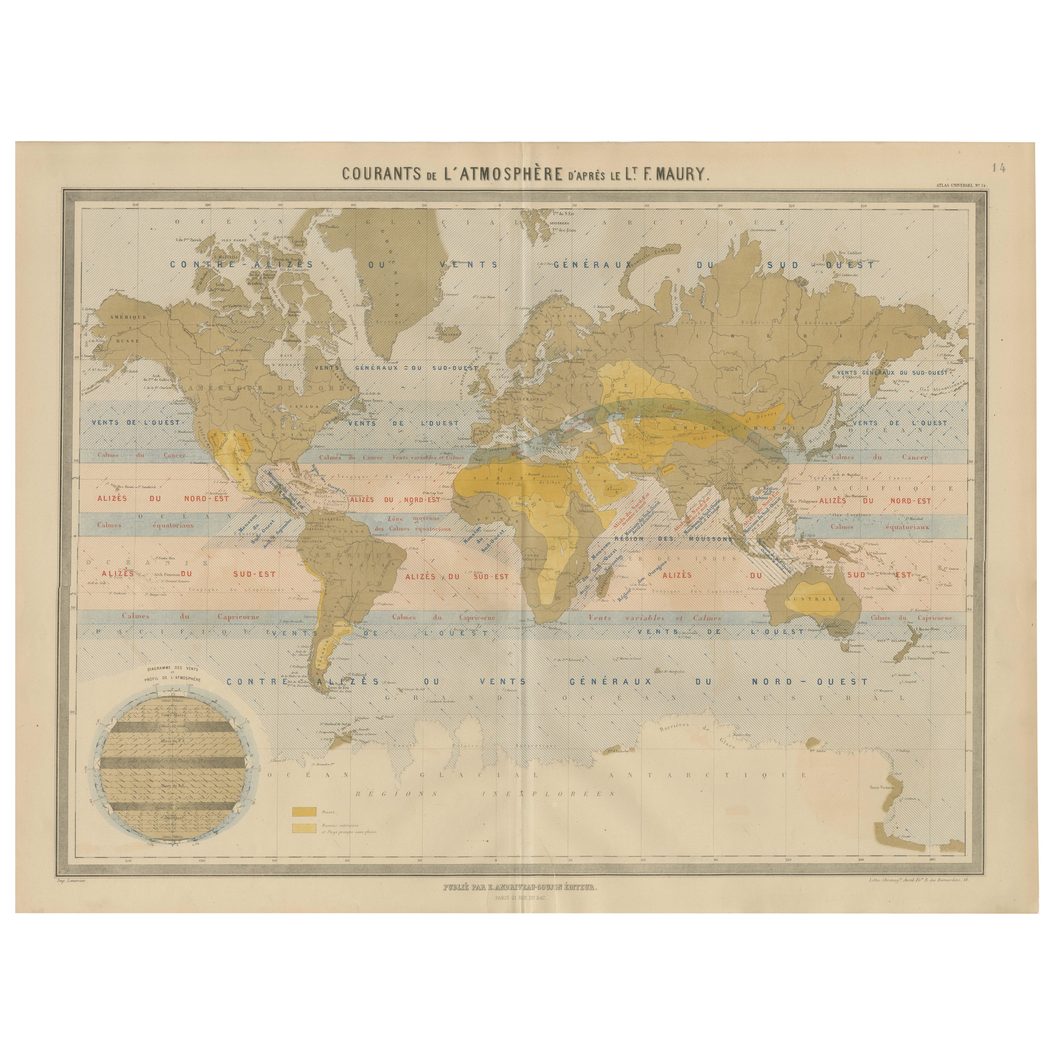
Weltkarte der Windströmungen - "Courants de l'Atmosphère" von Andriveau-Goujon, 1861
Weltkarte der Windströmungen - "Courants de l'Atmosphère" von Andriveau-Goujon, 1861
Diese eindrucksvolle und lehrreiche antike Karte mit dem Titel "Courants de l'Atmosphère d'après...
Kategorie
Antik, Mittleres 19. Jahrhundert, Französisch, Landkarten
Materialien
Papier

Antike Karte mit Isotherm-Linien auf der ganzen Welt von Johnston, um 1850
Antike Karte mit dem Titel 'Humboldt's System of Isothermal Lines'. Originale antike Karte mit Isothermenlinien in der ganzen Welt. Diese Karte stammt aus "The Physical Atlas of Natu...
Kategorie
Antik, Mittleres 19. Jahrhundert, Landkarten
Materialien
Papier

160 € Angebotspreis
20 % Rabatt
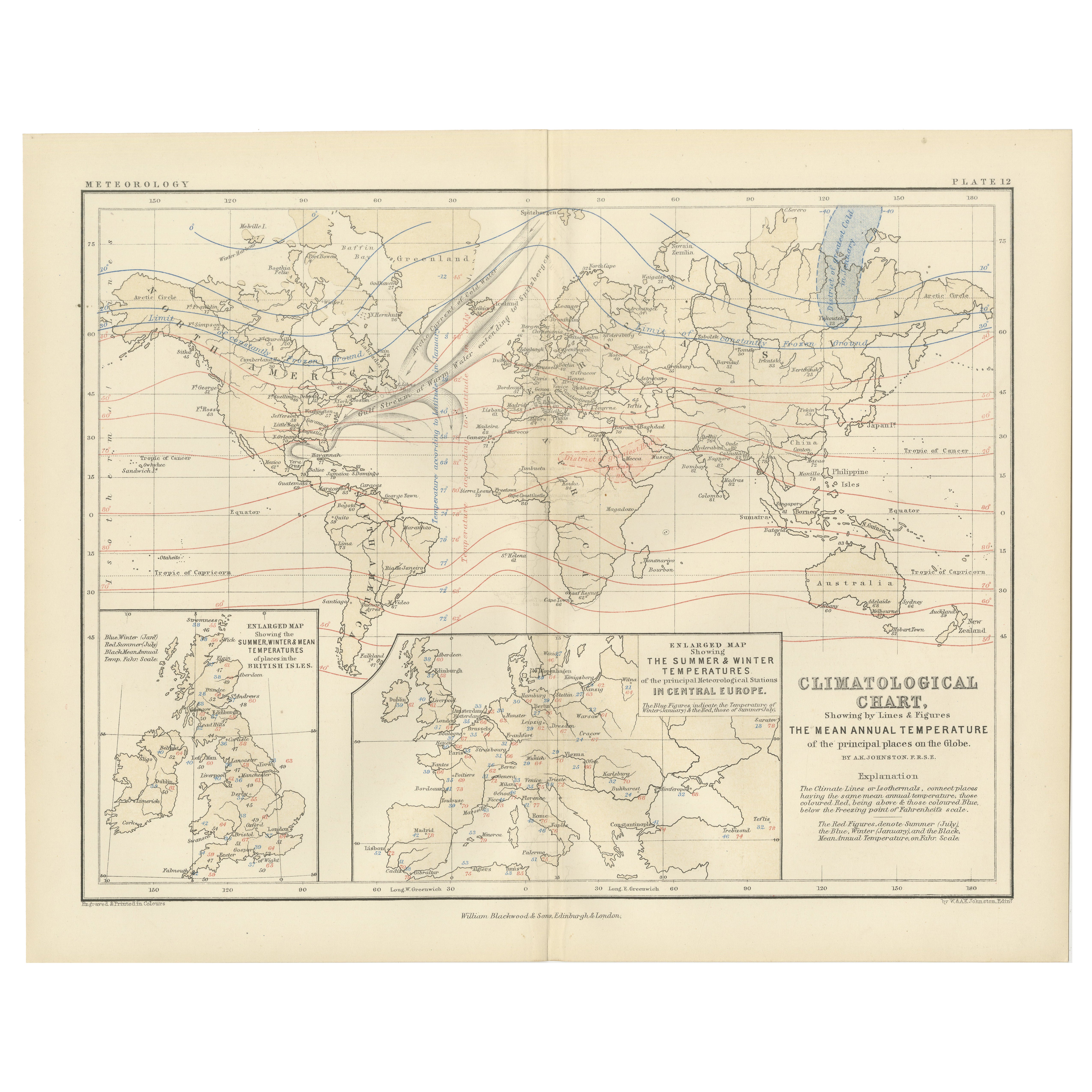
Climatological Map by A.K. Johnston – Global Temperatures Chart 1852
Climatological Map by A.K. Johnston – Global Temperatures Chart 1852
This exceptional antique map titled "Climatological Chart Showing by Lines & Figures the Mean Annual Temperature...
Kategorie
Antik, Mittleres 19. Jahrhundert, Schottisch, Drucke
Materialien
Papier
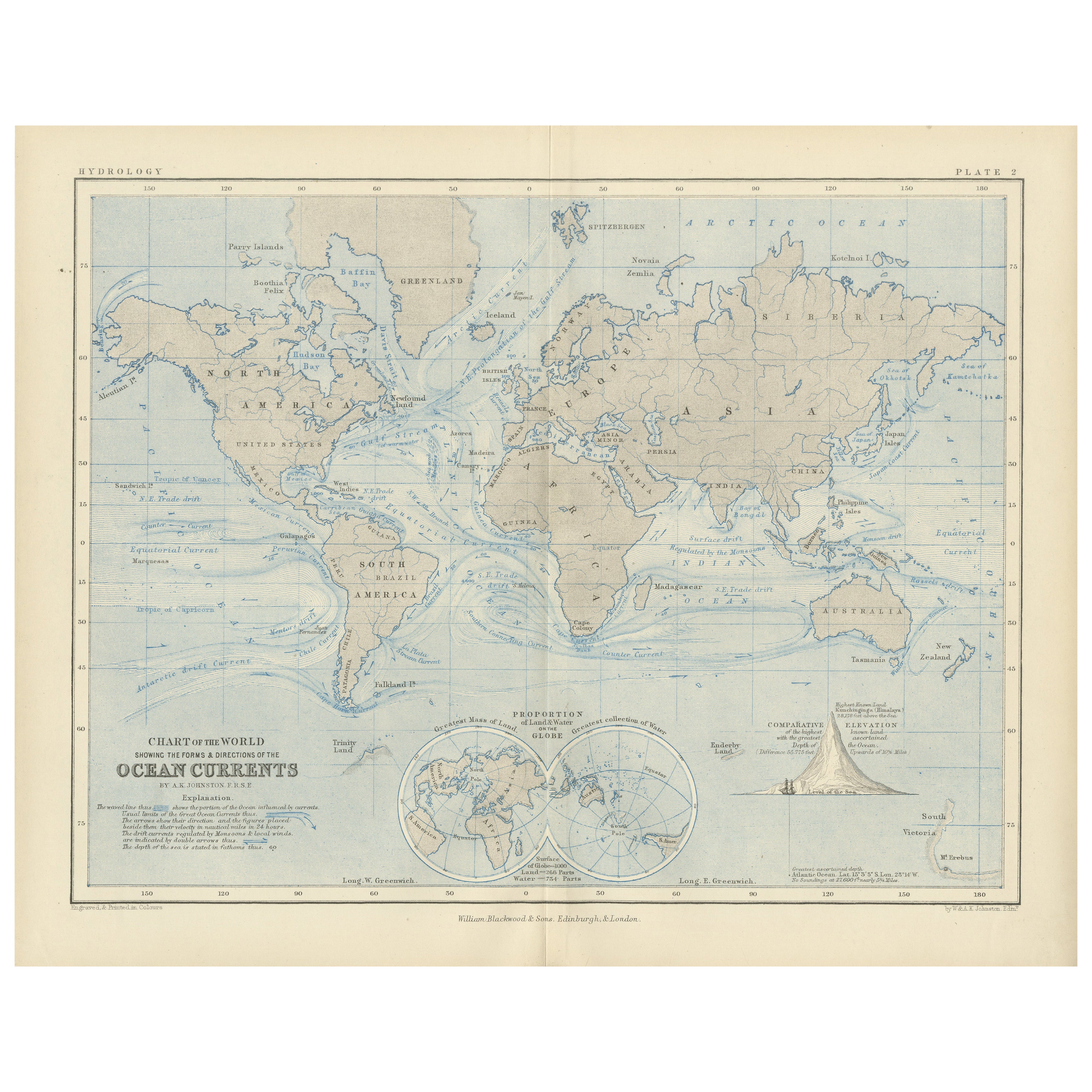
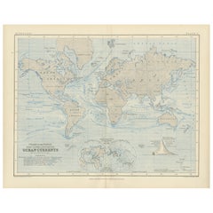
World Map of Ocean Currents by A.K. Johnston, Educational Print 1852
World Map of Ocean Currents by A.K. Johnston, Educational Print 1852
This detailed and scientifically rich chart titled 'Chart of the World Showing the Form & Direction of the Ocean...
Kategorie
Antik, Mittleres 19. Jahrhundert, Schottisch, Drucke
Materialien
Papier
Antike Karte der Meeresströmungen und der Lufttemperatur, '1872'.
Zwei Karten auf einem Blatt mit den Titeln 'Johnson's Oceans Currents (..)' und 'Johnson's World showing the Distribution of the Temperature of the Air'. Original-Weltkarte mit Darst...
Kategorie
Antik, Spätes 19. Jahrhundert, Landkarten
Materialien
Papier

280 € Angebotspreis
20 % Rabatt
Das könnte Ihnen auch gefallen
Original Antike Karte der westlichen Hemisphäre von Dower, circa 1835
Schöne Karte der westlichen Hemisphäre
Gezeichnet und gestochen von J. Dower
Herausgegeben von Orr & Smith. C.1835
Ungerahmt.
Kostenloser Versand
Kategorie
Antik, 1830er, Englisch, Landkarten
Materialien
Papier

Original illustrierte Planisphere von 1864 – Weltkarte – Geographie
Tauchen Sie ein in die epische Reise der Vergangenheit mit der Illustrierten Historischen Planisphäre von 1864 von Charpentier! 🗺️ Dieser kartografische Schatz entführt Sie in die F...
Kategorie
1860er, Druckgrafiken und Multiples
Materialien
Leinen, Lithografie, Papier

Hemisphäre des Neuen Kontinents – Antike Karte von J.G. Heck - 1834.
Von Johann Georg Heck
Hemisphäre des neuen Kontinents ist ein um 1760 entstandenes Kunstwerk von Johann Georg Heck
Original-Farbdruck.
Guter Zustand mit Ausnahme der Vergilbung des Papiers und der Einrisse am Rand.
Originaltitel Hemisphere du Nouveau Continent et ses Antipodes. Gedruckt bei Engelmann & Compagnie, S.F., Paris.
Dieser Druck ist die Tafel Nr. 7 aus "Atlas geographique, astronomique et historique, servant a l'intelligence de l'histoire ancienne, du moyen age et moderne et a la lecture des voyages les plus recens. Dresse d'apres les meilleurs materiaux tant francais qu'etrangers conformement aus progres de la science, par J.G. Mist."
Johann Georg Heck (1795 - 1857) war ein deutscher Buchhändler...
Kategorie
1830er, Moderne, Figurative Drucke
Materialien
Radierung

487 € Angebotspreis
25 % Rabatt
Original antike Weltkarte von Dower, um 1835
Schöne Karte der Welt
Gezeichnet und gestochen von J. Dower
Herausgegeben von Orr & Smith. C.1835
Ungerahmt.
Kostenloser Versand
Kategorie
Antik, 1830er, Englisch, Landkarten
Materialien
Papier

Original antike Karte der östlichen Hemisphäre von Dower, um 1835
Schöne Karte der östlichen Hemisphäre
Gezeichnet und gestochen von J. Dower
Herausgegeben von Orr & Smith. C.1835
Ungerahmt.
Kostenloser Versand
Kategorie
Antik, 1830er, Englisch, Landkarten
Materialien
Papier

Original antike Originalkarte der Welt von Thomas Clerk, 1817
Große Karte der östlichen und westlichen Hemisphäre
Auf 2 Blättern
Kupferstich
Gezeichnet und gestochen von Thomas Clerk, Edinburgh.
Veröffentlicht von Mackenzie und Dent...
Kategorie
Antik, 1810er, Englisch, Landkarten
Materialien
Papier
