Objekte ähnlich wie World Map of Ocean Currents by A.K. Johnston, Educational Print 1852


Möchten Sie mehr Bilder oder Videos?
Zusätzliche Bilder oder Videos von dem*der Anbieter*in anfordern
1 von 10
World Map of Ocean Currents by A.K. Johnston, Educational Print 1852
240 €pro Objekt|Einschließlich MwSt.
Menge
Angaben zum Objekt
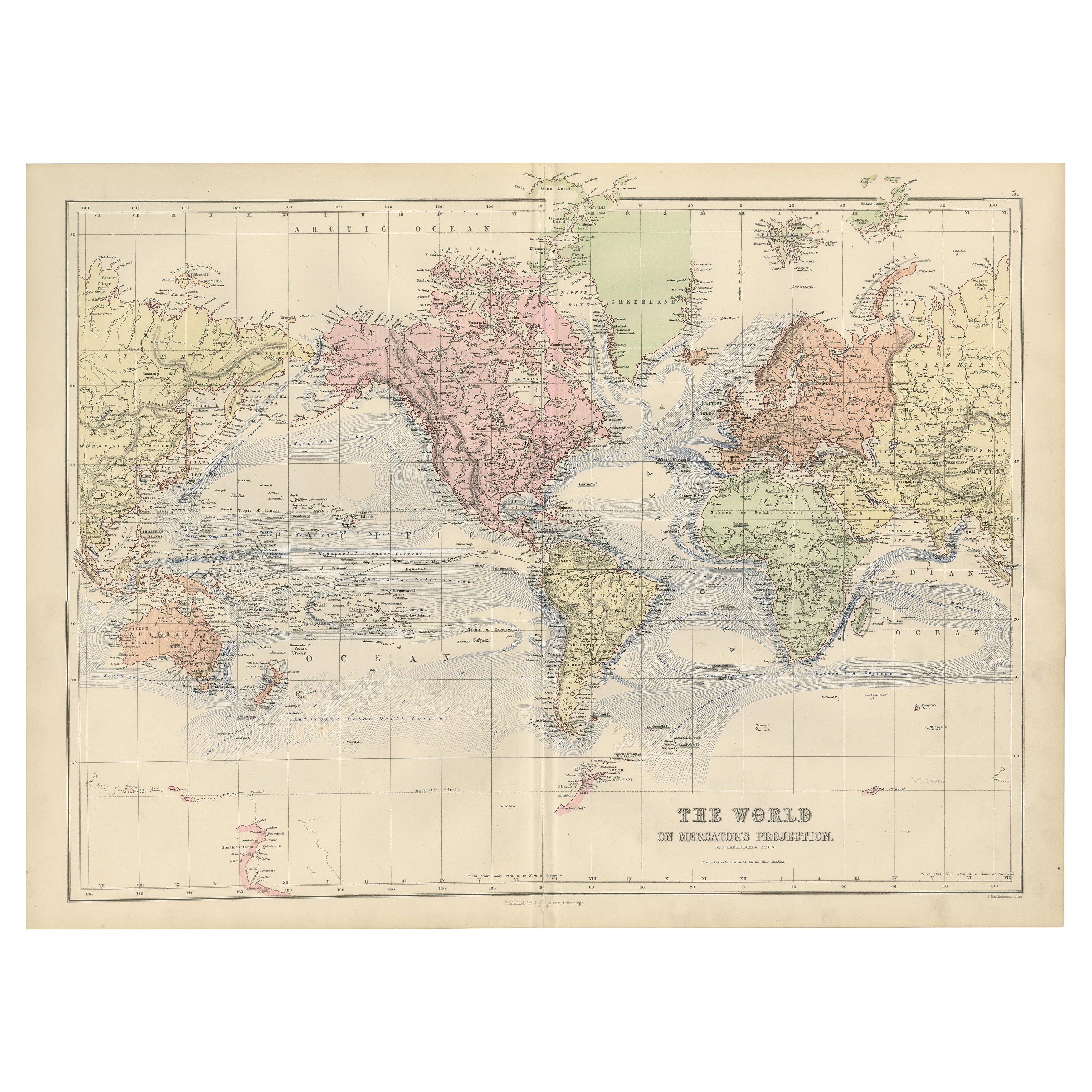
World Map of Ocean Currents by A.K. Johnston, Educational Print 1852
This detailed and scientifically rich chart titled 'Chart of the World Showing the Form & Direction of the Ocean Currents' was created by the Scottish cartographer Alexander Keith Johnston and published in 1852 by William Blackwood & Sons of Edinburgh and London. Issued as Plate 2 in a series on hydrology, it appeared in Johnston’s influential educational work *The Physical Atlas*.
The map illustrates the world’s ocean currents with remarkable clarity, using finely engraved directional arrows and shading to indicate both warm and cold currents across the globe’s seas. The Equatorial Current, Gulf Stream, Brazil Current, Kuroshio, and Antarctic Circumpolar Current are all clearly labeled and presented in relation to the major continents and climatic zones. The precise depiction of ocean flow patterns reveals the 19th-century understanding of global oceanography and its connection to trade, navigation, and climatology.
This map is not just a geographic representation, but a visual explanation of hydrological science. Two insets enhance the plate’s instructional value: one shows the “Proportion of Land & Water on the Globe,” and the other compares the relative elevation of mountain chains and ocean depths, including the Mariana Trench and Mount Everest. These contextual diagrams reflect the Enlightenment ideal of synthesizing visual data with scientific observation for public education.
Johnston (1804–1871) was known for merging scientific accuracy with elegant presentation. As “Geographer in Ordinary to Her Majesty for Scotland,” his maps were widely used in schools and universities. His Physical Atlas is considered one of the first thematic atlases, combining cartography with natural sciences.
This print is a compelling artifact of early scientific cartography, ideal for collectors of antique maps, maritime history, or 19th-century educational materials.
Condition and framing tips:
Excellent condition with minor age toning and clean margins. Frame in dark wood or matte black with a pale blue or neutral-toned mat to complement the soft blue engraving and highlight the fine scientific detailing.
- Maße:Höhe: 27,4 cm (10,79 in)Breite: 34,5 cm (13,59 in)Tiefe: 0,2 mm (0,01 in)
- Materialien und Methoden:
- Herkunftsort:
- Zeitalter:
- Herstellungsjahr:1852
- Zustand:Very good antique condition. Clean impression with light age-toning and minimal foxing. Edges show only minor wear. Fold in middle as issued. Suitable for immediate display or archival framing.
- Anbieterstandort:Langweer, NL
- Referenznummer:Anbieter*in: BG-13207-21stDibs: LU3054345385652
Anbieterinformationen
5,0
Anerkannte Anbieter*innen
Diese renommierten Anbieter*innen sind führend in der Branche und repräsentieren die höchste Klasse in Sachen Qualität und Design.
Platin-Anbieter*in
Premium-Anbieter*innen mit einer Bewertung über 4,7 und 24 Stunden Reaktionszeit
Gründungsjahr 2009
1stDibs-Anbieter*in seit 2017
2.641 Verkäufe auf 1stDibs
Typische Antwortzeit: <1 Stunde
- VersandAngebot wird abgerufen …Versand von: Langweer, Niederlande
- Rückgabebedingungen
Einige Inhalte dieser Seite wurden automatisch übersetzt. Daher kann 1stDibs nicht die Richtigkeit der Übersetzungen garantieren. Englisch ist die Standardsprache dieser Website.
Authentizitätsgarantie
Im unwahrscheinlichen Fall eines Problems mit der Echtheit eines Objekts kontaktieren Sie uns bitte innerhalb von 1 Jahr für eine volle Rückerstattung. DetailsGeld-Zurück-Garantie
Wenn Ihr Objekt nicht der Beschreibung entspricht, beim Transport beschädigt wurde oder nicht ankommt, kontaktieren Sie uns bitte innerhalb von 7 Tagen für eine vollständige Rückerstattung. DetailsStornierung innerhalb von 24 Stunden
Sie können Ihren Kauf jederzeit innerhalb von 24 Stunden stornieren, ohne jegliche Gründe dafür angeben zu müssen.Geprüfte Anbieter*innen
Unsere Anbieter*innen unterliegen strengen Dienstleistungs- und Qualitätsstandards, wodurch wir die Seriosität unserer Angebote gewährleisten können.Preisgarantie
Wenn Sie feststellen, dass ein*e Anbieter*in dasselbe Objekt anderswo zu einem niedrigeren Preis anbietet, werden wir den Preis entsprechend anpassen.Zuverlässige weltweite Lieferung
Unsere erstklassigen Versandunternehmen bieten spezielle Versandoptionen weltweit, einschließlich individueller Lieferung.Mehr von diesem*dieser Anbieter*in
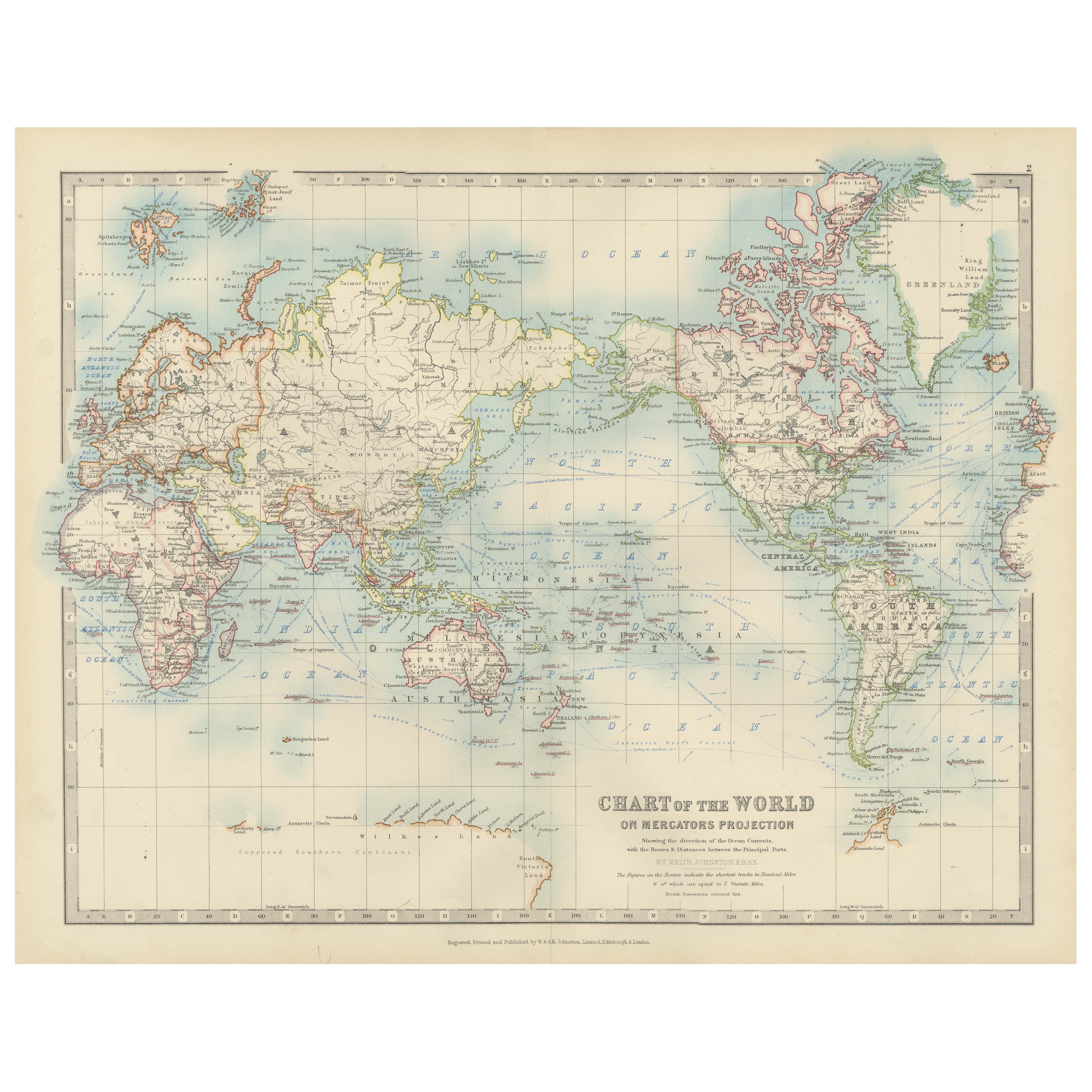
Alle anzeigenAntike Weltkarte auf Mercator-Projektion, Meeresströmungen und Handelsrouten 1903
Titel: Antike Weltkarte auf Mercator-Projektion, 1903, mit Darstellung der Meeresströmungen und Handelswege
Beschreibung:
Diese antike Karte mit dem Titel "Chart of the World on Mer...
Kategorie
Frühes 20. Jahrhundert, Landkarten
Materialien
Papier

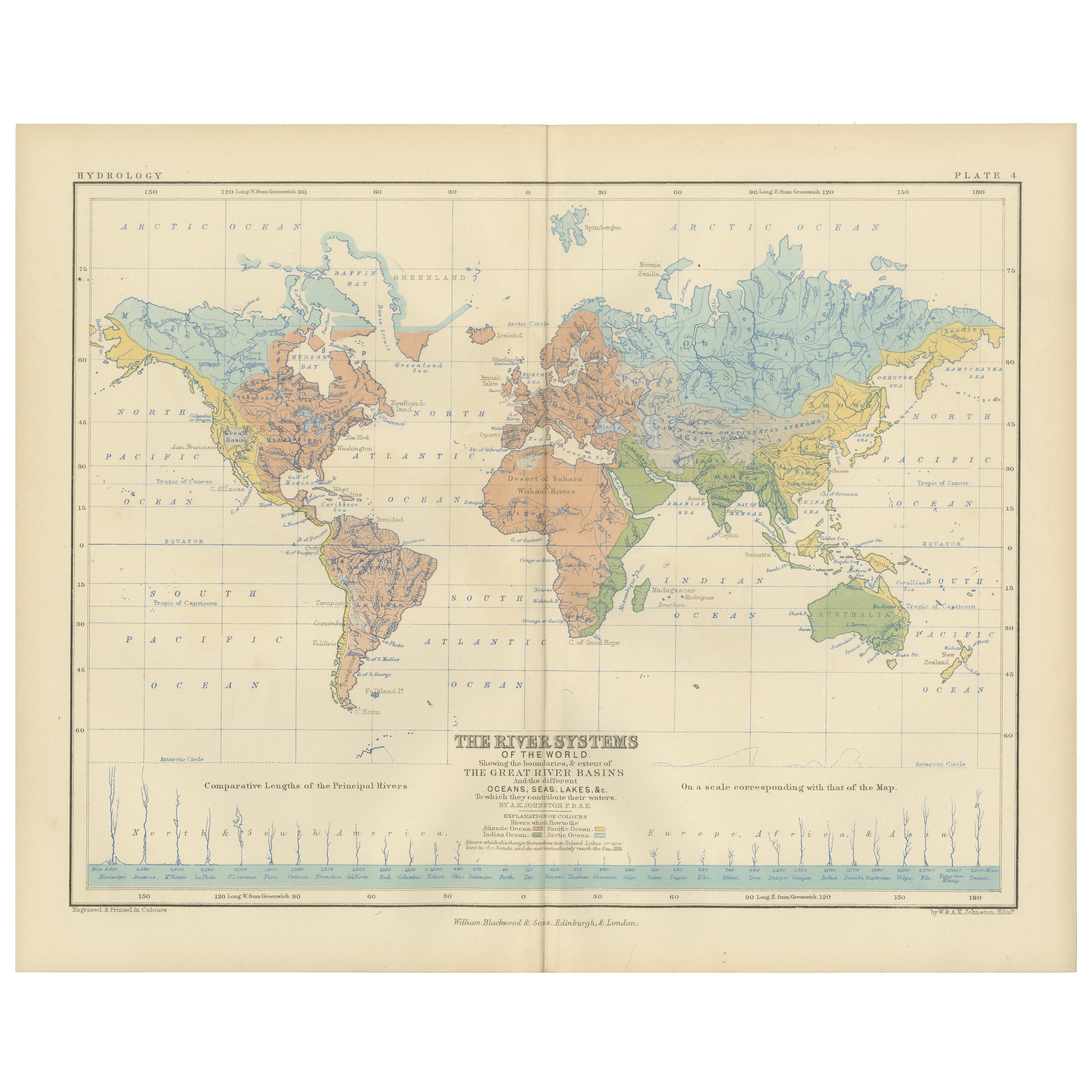
River Systems Map of the World by A.K. Johnston – Educational Print 1852
River Systems Map of the World by A.K. Johnston – Educational Print 1852
This striking 1852 map titled "The River Systems of the World" was created by the noted Scottish geographer ...
Kategorie
Antik, Mittleres 19. Jahrhundert, Schottisch, Drucke
Materialien
Papier

Antike Karte der Meeresströmungen und der Lufttemperatur, '1872'.
Zwei Karten auf einem Blatt mit den Titeln 'Johnson's Oceans Currents (..)' und 'Johnson's World showing the Distribution of the Temperature of the Air'. Original-Weltkarte mit Darst...
Kategorie
Antik, Spätes 19. Jahrhundert, Landkarten
Materialien
Papier

280 € Angebotspreis
20 % Rabatt
Wind and Hurricane Map by A.K. Johnston – Meteorological Chart 1852
Wind and Hurricane Map by A.K. Johnston – Meteorological Chart 1852
This scientifically significant 1852 map titled "The Distribution of the Constant, Periodical & Variable Winds Ov...
Kategorie
Antik, Mittleres 19. Jahrhundert, Schottisch, Drucke
Materialien
Papier

Antike Karte mit der Darstellung der Verteilung der aktuellen Luftdaten von Johnston „1850“
Antike Karte mit dem Titel "Geografische Verteilung der Luftströme". Originale antike Karte, die die Verteilung der Luftströme zeigt. Diese Karte stammt aus "The Physical Atlas of Na...
Kategorie
Antik, Mittleres 19. Jahrhundert, Landkarten
Materialien
Papier

160 € Angebotspreis
20 % Rabatt
1884 Antike dekorative Weltkarte - Mercator Projektion, viktorianische Epoche Druck
Antike Weltkarte auf Mercator-Projektion - Black's Atlas, 1884
Diese fein gestochene und kolorierte Karte mit dem Titel The World on Mercator's Projection wurde in der New and Revis...
Kategorie
Antik, 1880er, Schottisch, Landkarten
Materialien
Papier

Das könnte Ihnen auch gefallen
Große Original-Antiquitätenkarte des pazifischen Ozeans, Fullarton, um 1870
Große Karte des Pazifischen Ozeans
Aus dem berühmten Royal Illustrated Atlas
Lithographie von Swanston. Originalfarbe.
Herausgegeben von Fullarton, Edinburgh. C.1870
Rep...
Kategorie
Antik, 1870er, Schottisch, Landkarten
Materialien
Papier

Original antike Weltkarte von Dower, um 1835
Schöne Karte der Welt
Gezeichnet und gestochen von J. Dower
Herausgegeben von Orr & Smith. C.1835
Ungerahmt.
Kostenloser Versand
Kategorie
Antik, 1830er, Englisch, Landkarten
Materialien
Papier

Original illustrierte Planisphere von 1864 – Weltkarte – Geographie
Tauchen Sie ein in die epische Reise der Vergangenheit mit der Illustrierten Historischen Planisphäre von 1864 von Charpentier! 🗺️ Dieser kartografische Schatz entführt Sie in die F...
Kategorie
1860er, Druckgrafiken und Multiples
Materialien
Leinen, Lithografie, Papier

Original Antike Karte der westlichen Hemisphäre von Dower, circa 1835
Schöne Karte der westlichen Hemisphäre
Gezeichnet und gestochen von J. Dower
Herausgegeben von Orr & Smith. C.1835
Ungerahmt.
Kostenloser Versand
Kategorie
Antik, 1830er, Englisch, Landkarten
Materialien
Papier

Antike Karte von Ozeanien - Original-Radierung - 19. Jahrhundert
Diese Karte von Ozeanien ist eine Radierung aus dem 19. Jahrhundert.
Der Erhaltungszustand der Kunstwerke ist gut. Oben auf dem Papier steht die Aufschrift "Longitudine del Meridian...
Kategorie
19. Jahrhundert, Mehr Drucke
Materialien
Radierung

Karte der Welt – Original-Radierung – 1820
Die Weltkarte ist eine Original-Radierung eines unbekannten Künstlers des 19. Jahrhunderts aus dem Jahr 1820.
Sehr guter Zustand auf zwei in der Mitte verbundenen weißen Blättern.
...
Kategorie
1820er, Moderne, Figurative Drucke
Materialien
Radierung
