Artículos similares a Rain and Snow Map by A.K. Johnston – Global Precipitation Chart 1852


¿Quieres más imágenes o vídeos?
Solicita imágenes o vídeos adicionales al vendedor
1 de 11
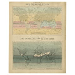
Rain and Snow Map by A.K. Johnston – Global Precipitation Chart 1852
260 €por artículo|IVA incluido
Cantidad
Acerca del artículo
Rain and Snow Map by A.K. Johnston – Global Precipitation Chart 1852
This antique meteorological chart titled "The Distribution of Rain and Snow over the Globe" was created by Alexander Keith Johnston and published in 1852 by William Blackwood & Sons in Edinburgh and London. It is Plate 14 from Johnston’s groundbreaking *Physical Atlas of Natural Phenomena*, a landmark 19th-century atlas that visually documented natural science using elegant cartographic design.
This thematic map represents one of the earliest global attempts to chart patterns of precipitation, displaying how rainfall and snowfall vary according to geography, latitude, topography, and proximity to oceans. The map divides the world into meteorological zones based on the frequency and regularity of rainfall. Shaded bands mark areas of constant equatorial rainfall, seasonal monsoon regions, zones of periodic tropical downpours, and drier arid zones such as the Sahara, Arabian Peninsula, central Australia, and western South America.
The map is annotated with explanatory observations, including statements such as “rains fall only at night and early morning” and “rains accompany heat and decrease with altitude,” reflecting the 19th-century state of meteorological knowledge. Areas with snowfall or extremely low precipitation are also marked, highlighting the climatological variety across continents.
In addition to the main map, the plate includes three detailed diagrams:
* A vertical section comparing snow-line elevations across different mountain ranges worldwide.
* A graph illustrating the relationship between precipitation and temperature.
* A chart showing how rainfall decreases with increasing distance from coastal regions.
Johnston (1804–1871), Geographer in Ordinary to Queen Victoria in Scotland, was among the first to bring natural science into the visual domain through cartography. His *Physical Atlas* is considered one of the most influential works of 19th-century thematic mapping, and this plate is a remarkable example of its ambition and execution.
This print offers collectors and scholars a glimpse into early meteorological theory and global climatology. Its elegant engraving and carefully hand-colored zones also make it an attractive decorative item for libraries, offices, and scientific interiors.
Condition and framing tips:
Good condition with light toning and mild signs of age near the edges. Printed surface clean and crisp. Best framed in dark wood or matte black with a neutral or parchment mat to bring out the warm tonal shading of the climatic zones. A refined and thought-provoking piece for any natural science or vintage cartography collection.
- Dimensiones:Altura: 27,4 cm (10,79 in)Anchura: 34,5 cm (13,59 in)Profundidad: 0,2 mm (0,01 in)
- Materiales y técnicas:
- Lugar de origen:
- Época:
- Fecha de fabricación:1852
- Estado:Very good condition. Light overall toning near the margins. The paper remains strong and well-preserved. Folding line as issued.
- Ubicación del vendedor:Langweer, NL
- Número de referencia:Vendedor: BG-13207-141stDibs: LU3054345393472
Sobre el vendedor
5,0
Vendedor reconocido
Estos prestigiosos vendedores son líderes del sector y representan el escalón más alto en cuanto a calidad y diseño de artículos.
Vendedor Platino
Vendedores premium con una calificación de +4,7 y tiempos de respuesta de 24 horas
Establecido en 2009
Vendedor de 1stDibs desde 2017
2647 ventas en 1stDibs
Tiempo de respuesta usual: <1 hora
- EnvíoRecuperando presupuesto…Envío desde: Langweer, Países Bajos
- Política de devolución
Partes de esta página se han traducido automáticamente. 1stDibs no puede garantizar la exactitud de las traducciones. El inglés es el idioma predeterminado de este sitio web.
Garantía de autenticidad
En el improbable caso de que haya algún problema con la autenticidad de un artículo, ponte en contacto con nosotros en un plazo de 1 año para recibir un reembolso total. DetallesGarantía de devolución de dinero
Si tu artículo no es como se describe, sufre daños durante el transporte o no llega, ponte en contacto con nosotros en un plazo de 7 días para recibir un reembolso total. DetallesCancelación dentro de las 24 horas
Tienes un período de gracia de 24 horas para reconsiderar tu compra, sin preguntas.Vendedores profesionales aprobados
Nuestros vendedores de primera clase deben cumplir estrictos estándares de servicio para mantener la integridad de nuestros anuncios.Garantía de igualación de precios
Si encuentras que un vendedor publicó el mismo artículo por un precio menor en otro lado, igualaremos ese precio.Entrega global de confianza
Nuestra red de transporte de primera ofrece opciones de envío especializado en todo el mundo, que incluye envío personalizado.Más de este vendedor
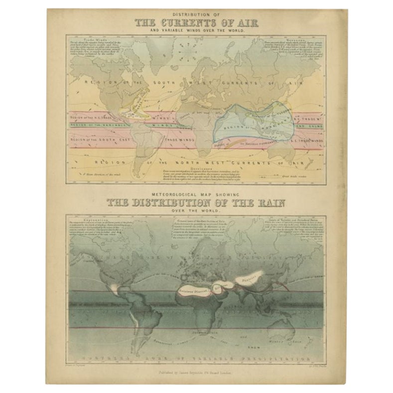
Ver todoMapa antiguo de la distribución del aire y la lluvia por Reynolds, 1843
Dos mapamundis antiguos en una sola hoja. El mapa superior muestra la distribución de las corrientes de aire y los vientos variables sobre el mundo. El mapa meteorológico inferior mu...
Categoría
Antiguo, siglo XIX, Mapas
Materiales
Papel
143 € Precio de venta
Descuento del 20 %
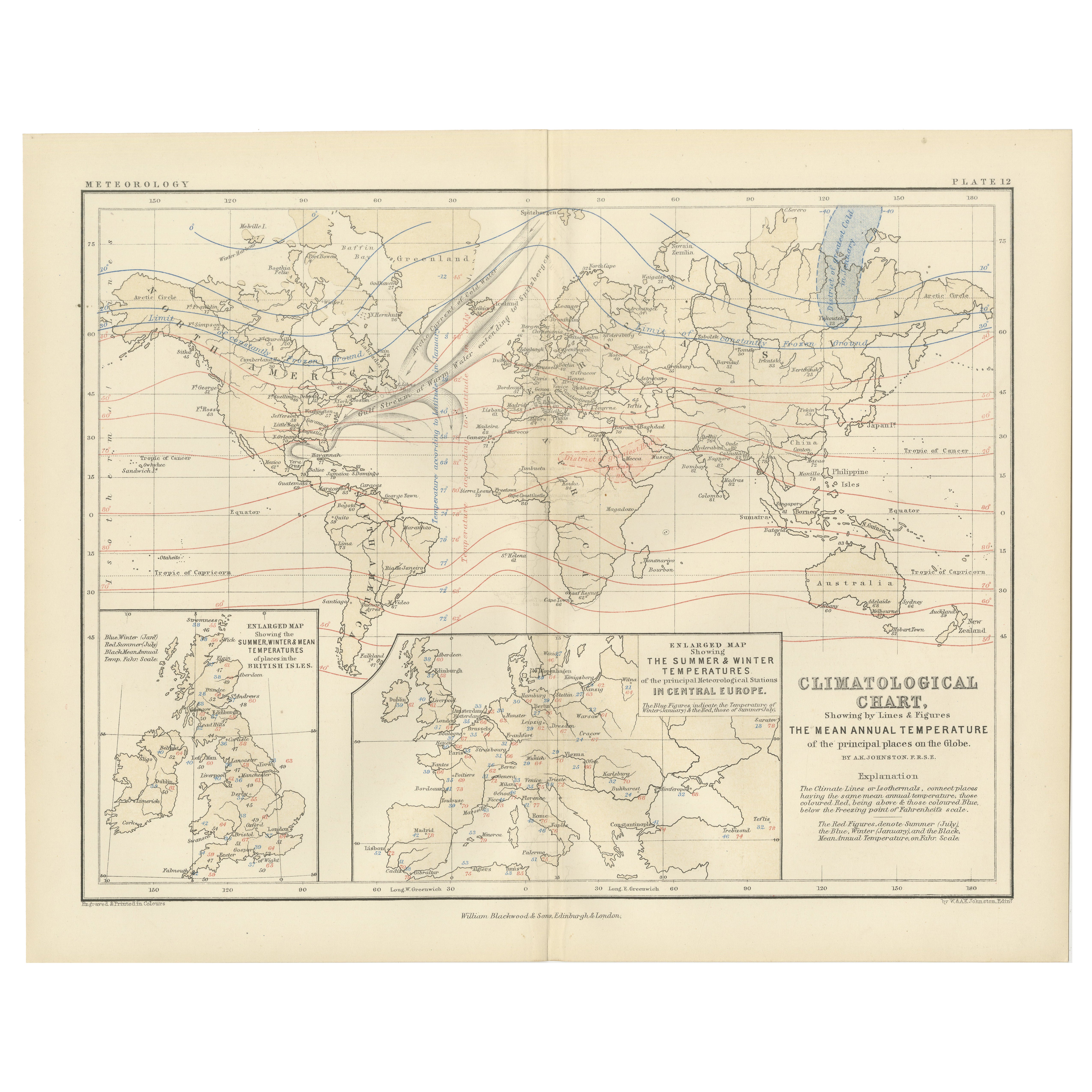
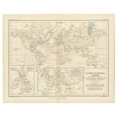
Climatological Map by A.K. Johnston – Global Temperatures Chart 1852
Climatological Map by A.K. Johnston – Global Temperatures Chart 1852
This exceptional antique map titled "Climatological Chart Showing by Lines & Figures the Mean Annual Temperature...
Categoría
Antiguo, Mediados del siglo XIX, Escocés, Impresiones
Materiales
Papel
Antiguo Mapa Pluvial del Mundo por Johnston '1850
Mapa antiguo titulado "Mapa Hietográfico o Pluviométrico del Mundo". Antiguo mapamundi original de la lluvia. Este mapa procede de "El Atlas Físico de los Fenómenos Naturales" de A.K...
Categoría
Antiguo, Mediados del siglo XIX, Mapas
Materiales
Papel

160 € Precio de venta
Descuento del 20 %
Wind and Hurricane Map by A.K. Johnston – Meteorological Chart 1852
Wind and Hurricane Map by A.K. Johnston – Meteorological Chart 1852
This scientifically significant 1852 map titled "The Distribution of the Constant, Periodical & Variable Winds Ov...
Categoría
Antiguo, Mediados del siglo XIX, Escocés, Impresiones
Materiales
Papel

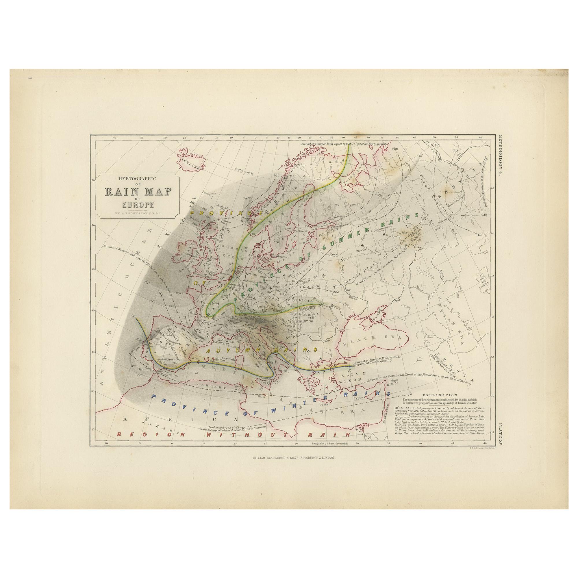
Antiguo Mapa Pluvial de Europa por Johnston '1850
Mapa antiguo titulado "Mapa Hietográfico o Pluviométrico de Europa". Mapa original antiguo de la lluvia de Europa. Este mapa procede de "El Atlas Físico de los Fenómenos Naturales" d...
Categoría
Antiguo, Mediados del siglo XIX, Mapas
Materiales
Papel

160 € Precio de venta
Descuento del 20 %
Mapa antiguo del mundo con la distribución de plantas y minerales, 1872
Mapa antiguo titulado 'El mundo de Johnson mostrando la distribución de los árboles forestales característicos (..)'. Mapamundi original que muestra la distribución de plantas y mine...
Categoría
Antiguo, Fines del siglo XIX, Mapas
Materiales
Papel

160 € Precio de venta
Descuento del 20 %
También te puede gustar
Mapa del Mundo - Grabado original - 1820
Mapa del Mundo es un Grabado Original realizado por un artista desconocido del siglo XIX en 1820.
Muy buen estado en dos hojas de papel blanco unidas por el centro.
El mapa es un a...
Categoría
Década de 1820, Moderno, Impresiones figurativas
Materiales
Grabado químico

Hemisferio del Nuevo Continente - Mapa antiguo de J.G. J. Heck - 1834.
Por Johann Georg Heck
Hemisferio del Nuevo Continente es una obra de arte realizada hacia 1760 por Johann Georg Heck
Impresión original en color.
Buen estado, salvo por el amarilleamiento del papel y l...
Categoría
Década de 1830, Moderno, Impresiones figurativas
Materiales
Grabado químico

487 € Precio de venta
Descuento del 25 %
1864 Planisferio ilustrado original - Mapamundi - Geografía
Sumérgete en el viaje épico del pasado con el Planisferio Histórico Ilustrado de 1864 de Charpentier! 🗺️ Este tesoro cartográfico te transporta a través de los entresijos de la hist...
Categoría
Década de 1860, Impresiones y múltiplos
Materiales
Lino, Litografía, Papel

Antiguo mapa original del mundo de Thomas Clerk, 1817
Gran mapa de los hemisferios oriental y occidental
En 2 hojas
Grabado en cobre
Dibujado y grabado por Thomas Clerk, Edimburgo.
Publicado por Mackenzie And Dent, 1817
S...
Categoría
Antiguo, Década de 1810, Inglés, Mapas
Materiales
Papel

Mapa antiguo del Imperio Británico - Mapa antiguo de Karl Spruner - 1760 ca.
Por Karl Spruner von Merz
Antiguo mapa del Imperio Británico es una obra de arte realizada hacia 1760 por Karl Spruner.
Grabado original coloreado a mano.
Buen estado, salvo por el amarilleamiento del papel...
Categoría
Década de 1760, Moderno, Impresiones figurativas
Materiales
Grabado químico

210 € Precio de venta
Descuento del 25 %
Mapa Antiguo Original del Mundo por Dower, circa 1835
Bonito mapa del Mundo
Dibujado y grabado por J.Dower
Publicado por Orr & Smith. C.1835
Sin enmarcar.
Envío gratuito
Categoría
Antiguo, Década de 1830, Inglés, Mapas
Materiales
Papel
