Artículos similares a Wind and Hurricane Map by A.K. Johnston – Meteorological Chart 1852


¿Quieres más imágenes o vídeos?
Solicita imágenes o vídeos adicionales al vendedor
1 de 10
Wind and Hurricane Map by A.K. Johnston – Meteorological Chart 1852
260 €por artículo|IVA incluido
Cantidad
Acerca del artículo
Wind and Hurricane Map by A.K. Johnston – Meteorological Chart 1852
This scientifically significant 1852 map titled "The Distribution of the Constant, Periodical & Variable Winds Over the Globe and the Regions Visited by Storms & Hurricanes" was produced by Alexander Keith Johnston and published by William Blackwood & Sons, Edinburgh and London. Issued as Plate 13 from Johnston’s acclaimed *Physical Atlas of Natural Phenomena*, this chart represents one of the earliest comprehensive visualizations of global wind patterns and storm activity.
The map displays worldwide atmospheric circulation zones, including the trade winds, westerlies, monsoons, and polar winds. Shaded areas and directional arrows show the dominant wind flows across latitudes, while regions of calms, such as the doldrums and horse latitudes, are clearly marked. The map is divided into latitudinal climate bands, offering a framework that reveals how wind systems vary seasonally and geographically.
Particularly notable are the detailed insets at the bottom, which highlight:
* The course of the Rodriguez hurricane on 13 April 1843.
* Seasonal monsoon shifts in the Indian Ocean.
* The pattern of hurricanes in the West Indies.
* Zones of equatorial and subtropical wind divergence.
These inset diagrams combine observational data with early meteorological theory, helping to explain how storms originate and travel—an especially important concept during an era of global exploration and colonial maritime trade.
Alexander Keith Johnston (1804–1871), Geographer in Ordinary to Queen Victoria in Scotland, was a key figure in the evolution of thematic mapping. His *Physical Atlas* was groundbreaking for its use of visual language to communicate complex environmental and scientific information. The map remains an important historical document in the study of meteorology and global climatology.
This plate will appeal to collectors of early scientific prints, maritime history enthusiasts, and decorators seeking atmospheric, vintage cartographic works.
Condition and framing tips:
Very good condition with minor age toning and original centerfold as issued. Printed area clean and well preserved. Frame in a classic dark wood or black frame with an ivory, parchment, or pale tan mat to enhance the warm earth tones and precise linework. A unique and intelligent addition to a study, library, or natural history-themed space.
- Dimensiones:Altura: 27,4 cm (10,79 in)Anchura: 34,5 cm (13,59 in)Profundidad: 0,2 mm (0,01 in)
- Materiales y técnicas:
- Lugar de origen:
- Época:
- Fecha de fabricación:1852
- Estado:Very good condition. Light overall toning near the margins. The paper remains strong and well-preserved. Folding line as issued.
- Ubicación del vendedor:Langweer, NL
- Número de referencia:Vendedor: BG-13207-131stDibs: LU3054345393452
Sobre el vendedor
5,0
Vendedor reconocido
Estos prestigiosos vendedores son líderes del sector y representan el escalón más alto en cuanto a calidad y diseño de artículos.
Vendedor Platino
Vendedores premium con una calificación de +4,7 y tiempos de respuesta de 24 horas
Establecido en 2009
Vendedor de 1stDibs desde 2017
2641 ventas en 1stDibs
Tiempo de respuesta usual: <1 hora
- EnvíoRecuperando presupuesto…Envío desde: Langweer, Países Bajos
- Política de devolución
Partes de esta página se han traducido automáticamente. 1stDibs no puede garantizar la exactitud de las traducciones. El inglés es el idioma predeterminado de este sitio web.
Garantía de autenticidad
En el improbable caso de que haya algún problema con la autenticidad de un artículo, ponte en contacto con nosotros en un plazo de 1 año para recibir un reembolso total. DetallesGarantía de devolución de dinero
Si tu artículo no es como se describe, sufre daños durante el transporte o no llega, ponte en contacto con nosotros en un plazo de 7 días para recibir un reembolso total. DetallesCancelación dentro de las 24 horas
Tienes un período de gracia de 24 horas para reconsiderar tu compra, sin preguntas.Vendedores profesionales aprobados
Nuestros vendedores de primera clase deben cumplir estrictos estándares de servicio para mantener la integridad de nuestros anuncios.Garantía de igualación de precios
Si encuentras que un vendedor publicó el mismo artículo por un precio menor en otro lado, igualaremos ese precio.Entrega global de confianza
Nuestra red de transporte de primera ofrece opciones de envío especializado en todo el mundo, que incluye envío personalizado.Más de este vendedor
Ver todoMapa antiguo que muestra la distribución de las corrientes de aire por Johnston '1850
Mapa antiguo titulado "Distribución geográfica de las corrientes de aire". Mapa original antiguo que muestra la distribución de las corrientes de aire. Este mapa procede de "El Atlas...
Categoría
Antiguo, Mediados del siglo XIX, Mapas
Materiales
Papel

160 € Precio de venta
Descuento del 20 %
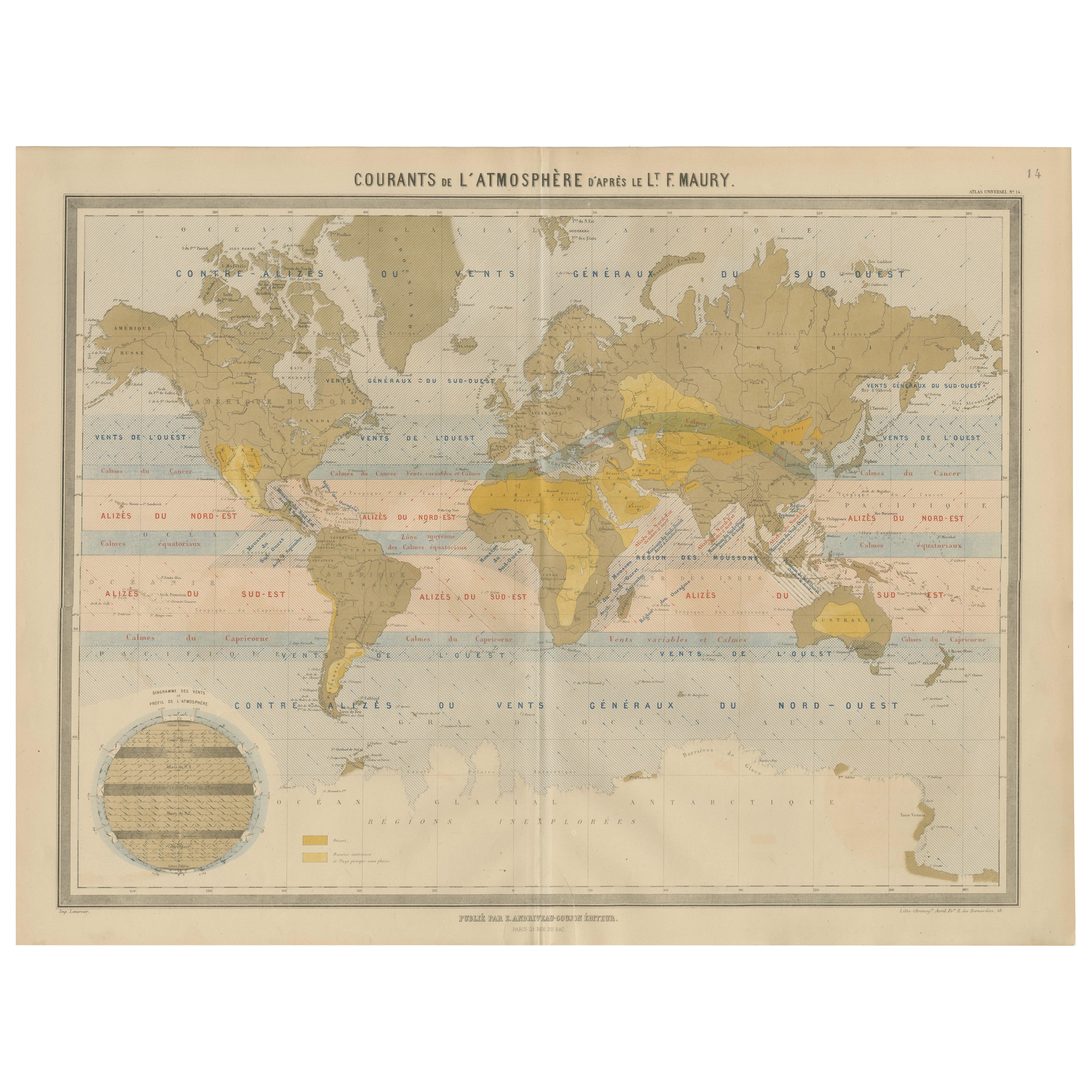
Mapa mundial de las corrientes de viento - "Courants de l'Atmosphère" de Andriveau-Goujon, 1861
Mapa mundial de las corrientes de viento - "Courants de l'Atmosphère" de Andriveau-Goujon, 1861
Este sorprendente y educativo gráfico antiguo titulado "Courants de l'Atmosphère d'ap...
Categoría
Antiguo, Mediados del siglo XIX, Francés, Mapas
Materiales
Papel

Mapa antiguo que muestra las líneas isotérmicas en todo el mundo por Johnston '1850
Mapa antiguo titulado "Sistema de líneas isotérmicas de Humboldt". Mapa original antiguo que muestra las líneas de isoterma en todo el mundo. Este mapa procede de "El Atlas Físico de...
Categoría
Antiguo, Mediados del siglo XIX, Mapas
Materiales
Papel

160 € Precio de venta
Descuento del 20 %
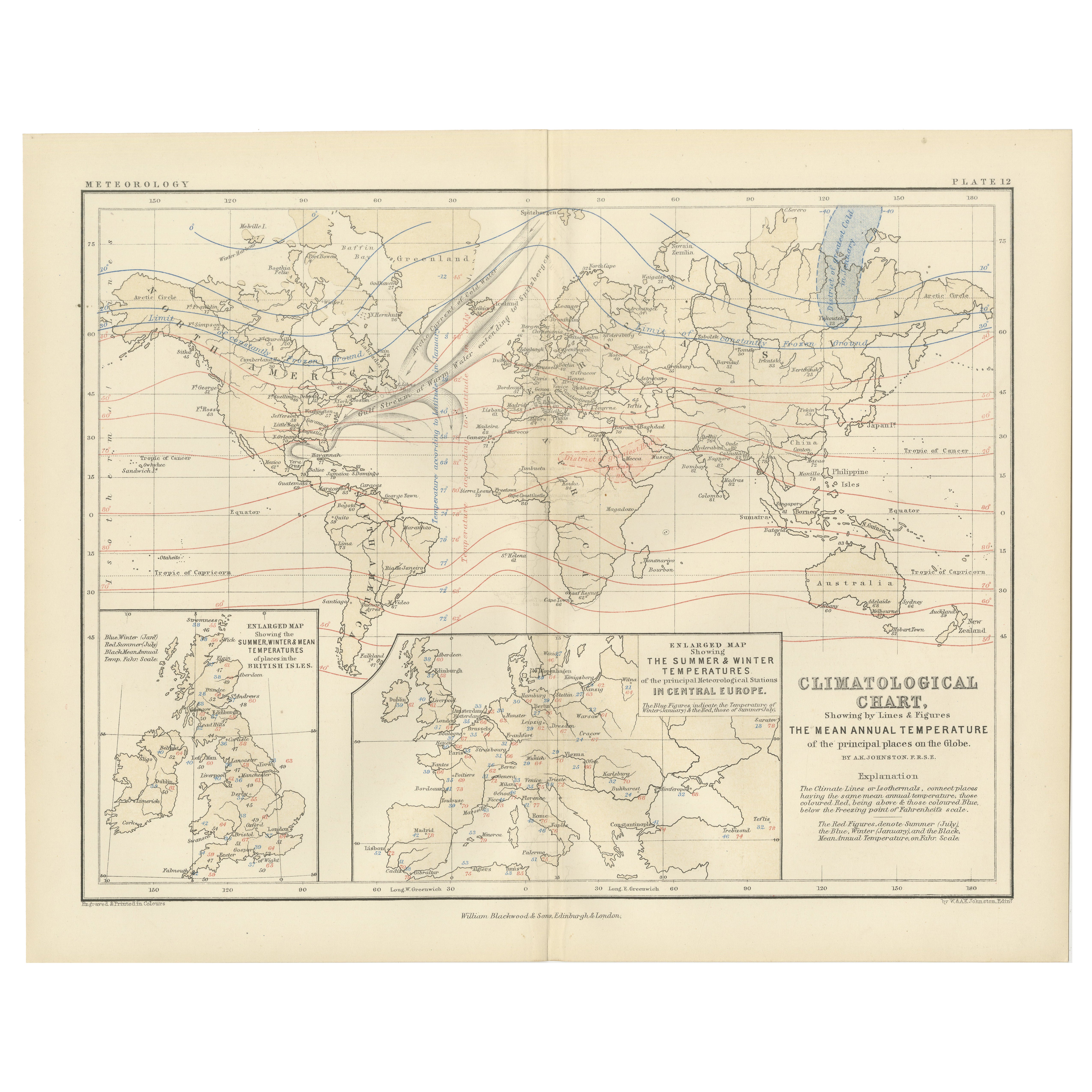
Climatological Map by A.K. Johnston – Global Temperatures Chart 1852
Climatological Map by A.K. Johnston – Global Temperatures Chart 1852
This exceptional antique map titled "Climatological Chart Showing by Lines & Figures the Mean Annual Temperature...
Categoría
Antiguo, Mediados del siglo XIX, Escocés, Impresiones
Materiales
Papel
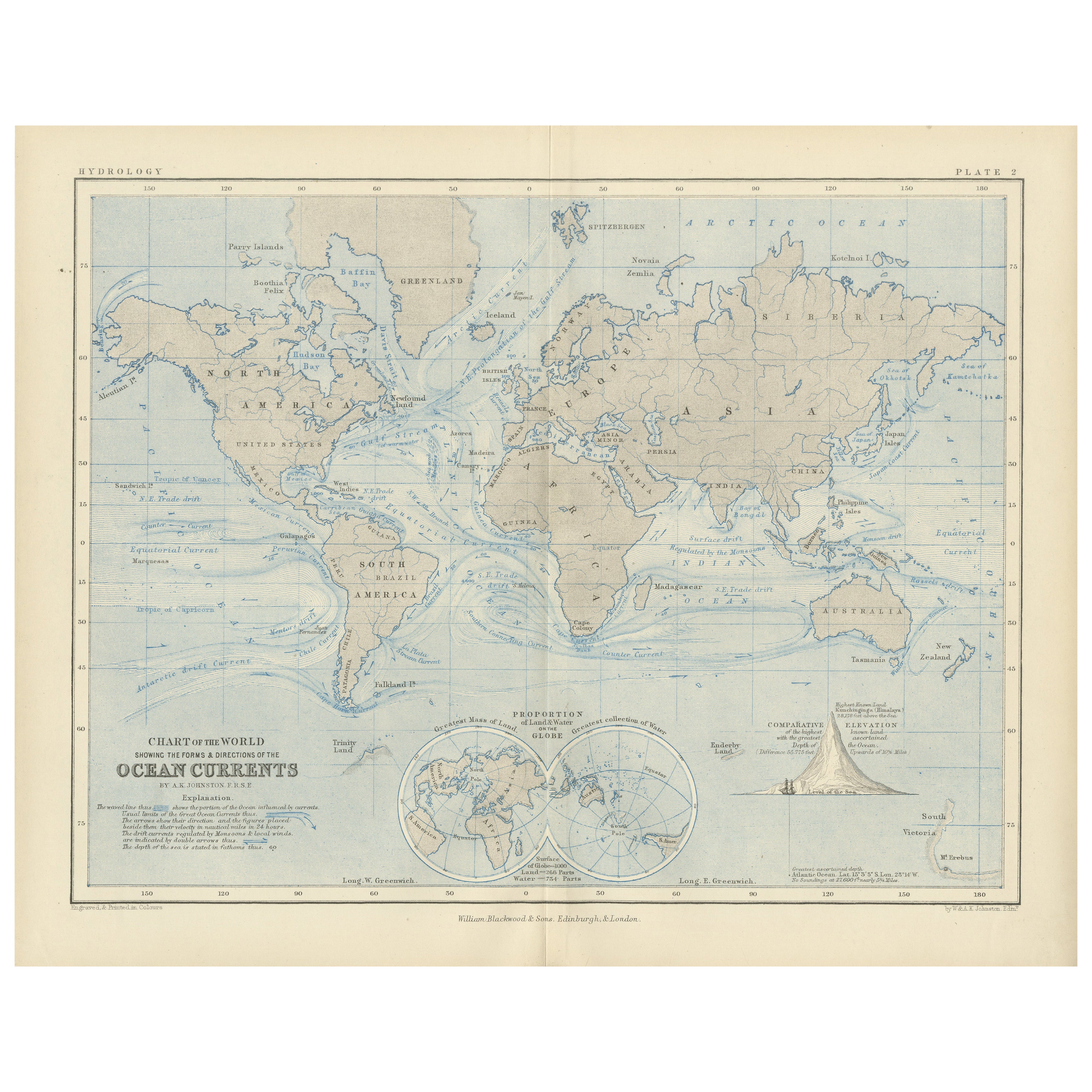
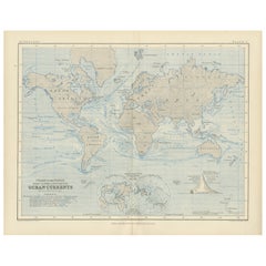
World Map of Ocean Currents by A.K. Johnston, Educational Print 1852
World Map of Ocean Currents by A.K. Johnston, Educational Print 1852
This detailed and scientifically rich chart titled 'Chart of the World Showing the Form & Direction of the Ocean...
Categoría
Antiguo, Mediados del siglo XIX, Escocés, Impresiones
Materiales
Papel
Mapa antiguo que muestra las corrientes oceánicas y la temperatura del aire, '1872
Dos mapas en una hoja titulados "Las corrientes oceánicas de Johnson (..)" y "El mundo de Johnson mostrando la distribución de la temperatura del aire". Mapamundi original que muestr...
Categoría
Antiguo, Fines del siglo XIX, Mapas
Materiales
Papel

280 € Precio de venta
Descuento del 20 %
También te puede gustar
Mapa original antiguo del hemisferio occidental por Dower, hacia 1835
Bonito mapa del Hemisferio Occidental
Dibujado y grabado por J.Dower
Publicado por Orr & Smith. C.1835
Sin enmarcar.
Envío gratuito
Categoría
Antiguo, Década de 1830, Inglés, Mapas
Materiales
Papel

1864 Planisferio ilustrado original - Mapamundi - Geografía
Sumérgete en el viaje épico del pasado con el Planisferio Histórico Ilustrado de 1864 de Charpentier! 🗺️ Este tesoro cartográfico te transporta a través de los entresijos de la hist...
Categoría
Década de 1860, Impresiones y múltiplos
Materiales
Lino, Litografía, Papel

Hemisferio del Nuevo Continente - Mapa antiguo de J.G. J. Heck - 1834.
Por Johann Georg Heck
Hemisferio del Nuevo Continente es una obra de arte realizada hacia 1760 por Johann Georg Heck
Impresión original en color.
Buen estado, salvo por el amarilleamiento del papel y l...
Categoría
Década de 1830, Moderno, Impresiones figurativas
Materiales
Grabado químico

487 € Precio de venta
Descuento del 25 %
Mapa Antiguo Original del Mundo por Dower, circa 1835
Bonito mapa del Mundo
Dibujado y grabado por J.Dower
Publicado por Orr & Smith. C.1835
Sin enmarcar.
Envío gratuito
Categoría
Antiguo, Década de 1830, Inglés, Mapas
Materiales
Papel

Mapa Antiguo Original del Hemisferio Oriental por Dower, hacia 1835
Bonito mapa del hemisferio oriental
Dibujado y grabado por J.Dower
Publicado por Orr & Smith. C.1835
Sin enmarcar.
Envío gratuito
Categoría
Antiguo, Década de 1830, Inglés, Mapas
Materiales
Papel

Antiguo mapa original del mundo de Thomas Clerk, 1817
Gran mapa de los hemisferios oriental y occidental
En 2 hojas
Grabado en cobre
Dibujado y grabado por Thomas Clerk, Edimburgo.
Publicado por Mackenzie And Dent, 1817
S...
Categoría
Antiguo, Década de 1810, Inglés, Mapas
Materiales
Papel
