Artículos similares a Antique Map of Africa, Highlighting Colonial Divisions, Geographic Features 1903


¿Quieres más imágenes o vídeos?
Solicita imágenes o vídeos adicionales al vendedor
1 de 10
Antique Map of Africa, Highlighting Colonial Divisions, Geographic Features 1903
Acerca del artículo
Title: Antique Map of Africa, 1903, Highlighting Colonial Divisions and Geographic Features
Description: This antique map, titled "Africa," was engraved and published in 1903 by W. & A.K. Johnston in Edinburgh and London. It provides a fascinating and detailed look at the African continent at the height of the colonial era, reflecting the complex interplay of geography, culture, and imperial ambitions.
Hand-colored in soft pastel shades, the map delineates the colonial territories that defined Africa during this period, including the spheres of influence of the British, French, German, Portuguese, Italian, Belgian, and Spanish empires. Major rivers, mountain ranges, and lakes are all clearly depicted, offering a rich geographical context for the colonial boundaries imposed by European powers.
The map’s elegant typography and refined linework capture the grandeur of Africa’s natural features and underscore the political realities of the time. From the Sahara Desert to the fertile Nile basin, from the Cape of Good Hope to the islands of the Indian Ocean, this map illustrates the diverse environments and cultures that make Africa such a dynamic and significant part of the world.
For collectors, historians, and those with an interest in African history, this map is more than a decorative piece—it is a testament to a pivotal period in the continent’s story, reflecting both the beauty of its landscapes and the dramatic changes brought by colonization.
Condition report:
This map is in very good antique condition, with only minor foxing and gentle edge toning typical for its age. The colors remain vibrant and the paper is stable and well-preserved.
Framing tips:
A classic wooden frame in walnut or cherry will enhance the soft pastel colors and historical detail of this map. Use a cream or off-white matting to highlight the refined linework and create a sophisticated, timeless focal point for any home, library, or study.
- Dimensiones:Altura: 36,8 cm (14,49 in)Anchura: 47 cm (18,51 in)Profundidad: 0,2 mm (0,01 in)
- Materiales y técnicas:
- Época:
- Fecha de fabricación:1903
- Estado:This map is in very good antique condition, with only minor foxing and gentle edge toning typical for its age. The colors remain vibrant and the paper is stable and well-preserved.
- Ubicación del vendedor:Langweer, NL
- Número de referencia:Vendedor: BG-13577-351stDibs: LU3054345271972
Sobre el vendedor
5,0
Vendedor reconocido
Estos prestigiosos vendedores son líderes del sector y representan el escalón más alto en cuanto a calidad y diseño de artículos.
Vendedor Oro
Vendedores premium que mantienen una calificación de +4,3 y tiempos de respuesta de 24 horas
Establecido en 2009
Vendedor de 1stDibs desde 2017
2452 ventas en 1stDibs
Tiempo de respuesta usual: <1 hora
- EnvíoRecuperando presupuesto…Envío desde: Langweer, Países Bajos
- Política de devolución
Partes de esta página se han traducido automáticamente. 1stDibs no puede garantizar la exactitud de las traducciones. El inglés es el idioma predeterminado de este sitio web.
Garantía de autenticidad
En el improbable caso de que haya algún problema con la autenticidad de un artículo, ponte en contacto con nosotros en un plazo de 1 año para recibir un reembolso total. DetallesGarantía de devolución de dinero
Si tu artículo no es como se describe, sufre daños durante el transporte o no llega, ponte en contacto con nosotros en un plazo de 7 días para recibir un reembolso total. DetallesCancelación dentro de las 24 horas
Tienes un período de gracia de 24 horas para reconsiderar tu compra, sin preguntas.Vendedores profesionales aprobados
Nuestros vendedores de primera clase deben cumplir estrictos estándares de servicio para mantener la integridad de nuestros anuncios.Garantía de igualación de precios
Si encuentras que un vendedor publicó el mismo artículo por un precio menor en otro lado, igualaremos ese precio.Entrega global de confianza
Nuestra red de transporte de primera ofrece opciones de envío especializado en todo el mundo, que incluye envío personalizado.Más de este vendedor
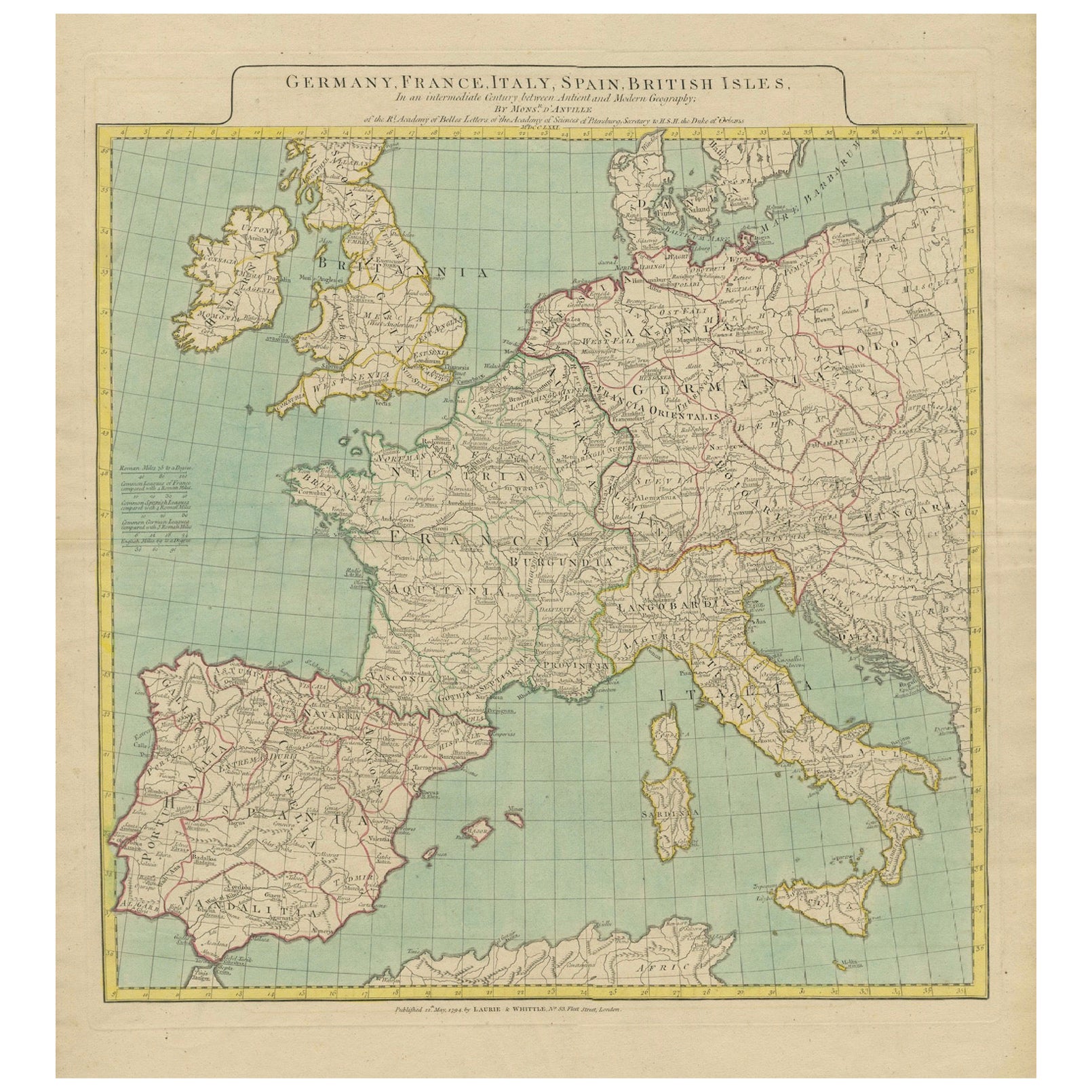
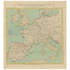
Ver todoMapa de Europa en el que se destacan las divisiones geográficas antiguas y modernas (1794)
Mapa de Europa en el que se destacan las divisiones geográficas antiguas y modernas (1794). Alemania, Francia, Italia, España y las Islas Británicas - Mapa de D'Anville (1794).
Est...
Categoría
Antiguo, Década de 1790, Mapas
Materiales
Papel
1577 US$ Precio de venta
Descuento del 20 %
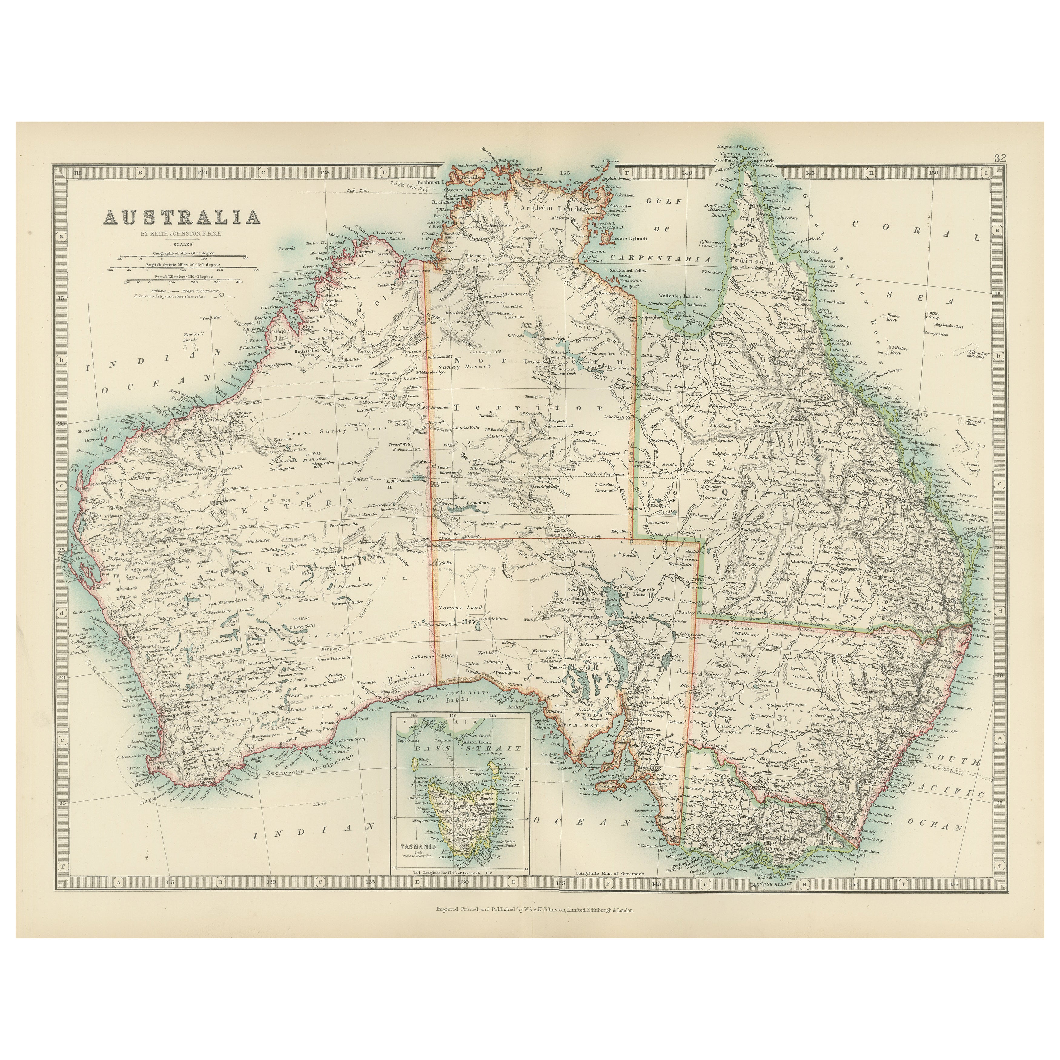
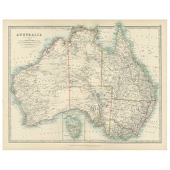
Antique Map of Australia, 1903, with Colonial Divisions and Detailed Topography
Title: Antique Map of Australia, 1903, with Colonial Divisions and Detailed Topography
Description: This antique map, titled "Australia," was engraved and published in 1903 by W. & ...
Categoría
principios del siglo XX, Mapas
Materiales
Papel
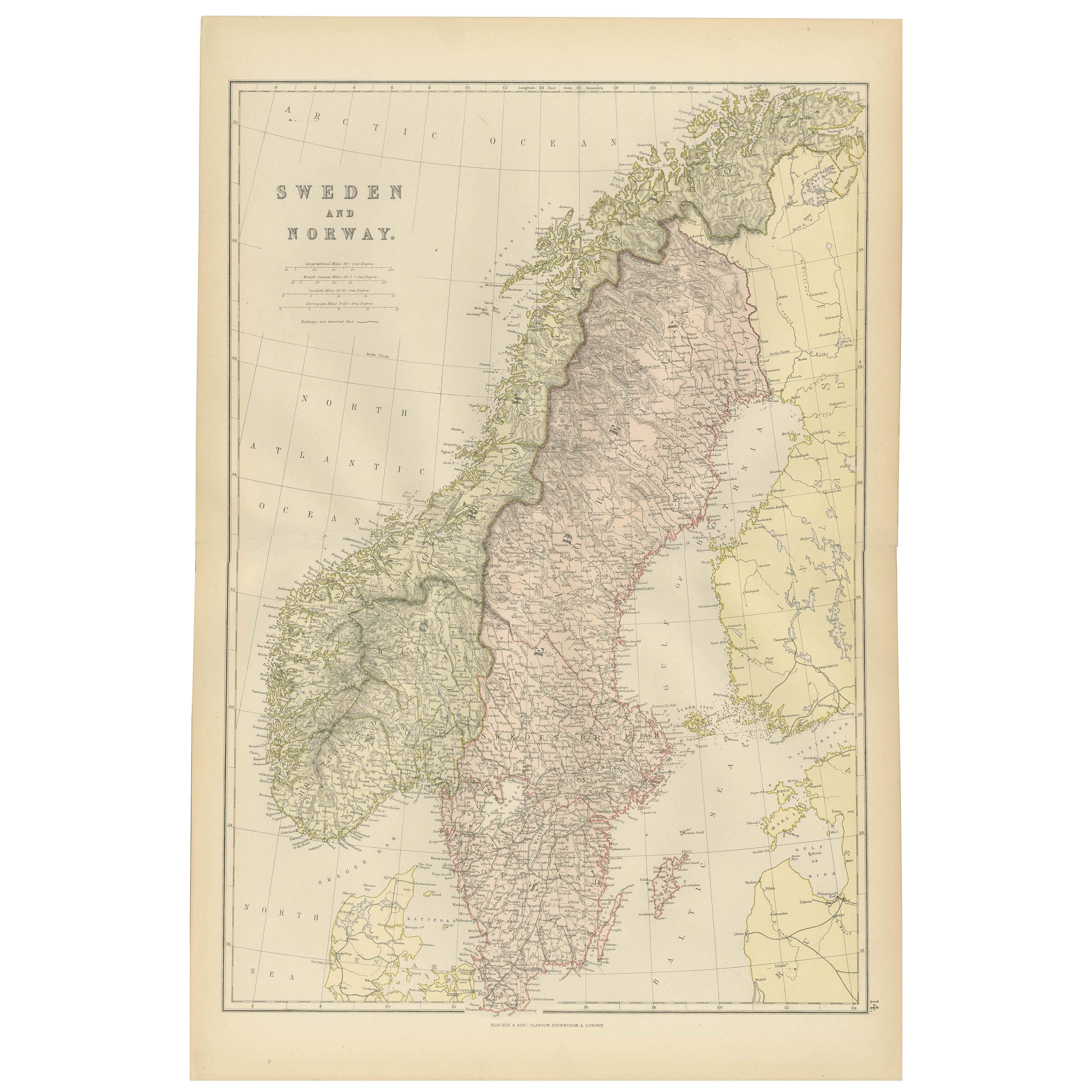
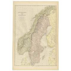
Mapa de Suecia y Noruega de 1882 en el que se destacan las características geográficas y políticas
Este mapa de Suecia y Noruega de 1882, publicado por Blackie and Son como parte del "Atlas y Geografía Completos del Mundo", ofrece una descripción detallada de la Península Escandin...
Categoría
Antiguo, Década de 1880, Mapas
Materiales
Papel
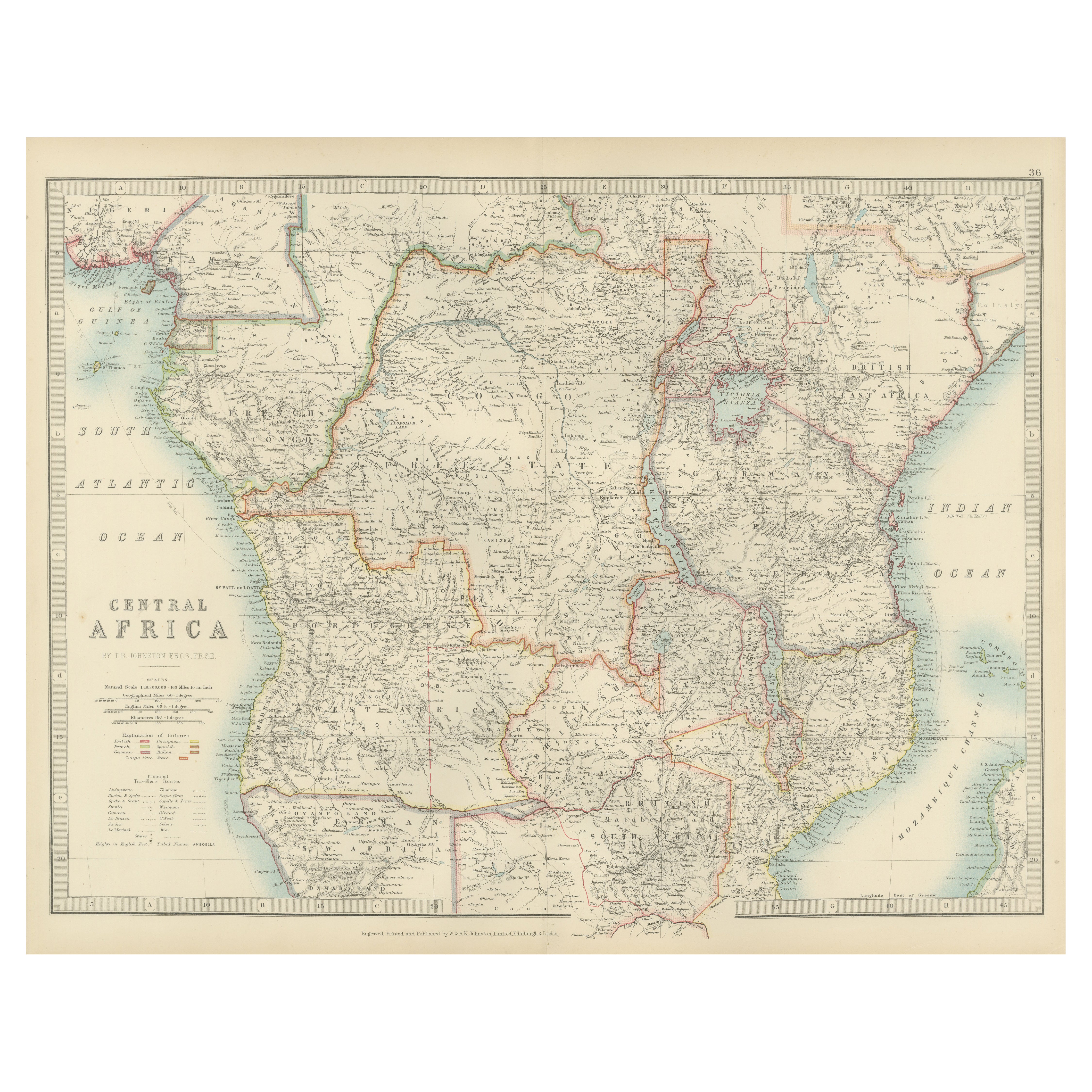
Antique Map of Central Africa, 1903, With Colonial Territories Explorers Routes
Antique Map of Central Africa, 1903, Featuring Colonial Territories and Explorers’ Routes
This antique map, titled "Central Africa," was engraved and published in 1903 by W. & A.K. ...
Categoría
principios del siglo XX, Mapas
Materiales
Papel

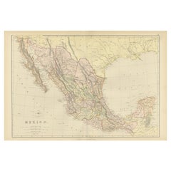
1882 Mapa antiguo de México en el que se destacan los límites geográficos y políticos
Este mapa de México de 1882, publicado por Blackie and Son como parte del "Atlas y Geografía Completos del Mundo", ofrece una representación muy detallada de la geografía y las divis...
Categoría
Antiguo, Década de 1880, Mapas
Materiales
Papel
Antique Map of Northern Scotland, 1903, with Intricate Coastal Features
Title: Antique Map of Northern Scotland and Islands, 1903, with Intricate Coastal Features
Description:
This striking antique map, titled "Scotland (Northern Sheet I)," was engraved...
Categoría
principios del siglo XX, Mapas
Materiales
Papel

También te puede gustar
Mapa Geográfico Antiguo del Principado de Mónaco
Por Bruno Santini
ST/609 - Interesante mapa antiguo en color del Principado de Mónaco en lengua francesa : "Carte qui contient le Principauté de Piémont, le Monferrat et la comté de Nice avec la Riviè...
Categoría
Antiguo, finales del siglo XVIII, Italiano, Otro, Mapas
Materiales
Papel

Mapa original antiguo del estado norteamericano de Minnesota, 1903
Mapa antiguo de Minnesota
Publicado por A & C Black. 1903
Color original
Buen estado
Sin enmarcar.
Envío gratuito
Categoría
Antiguo, Principios del 1900, Inglés, Mapas
Materiales
Papel

Mapa original antiguo del estado norteamericano de Alabama, 1903
Antique map of Alabama
Published By A & C Black. 1903
Original colour
Good condition
Unframed.
Free shipping
Categoría
Antiguo, Principios del 1900, Inglés, Mapas
Materiales
Papel

Mapa original antiguo del estado norteamericano de Alaska, 1903
Mapa antiguo de Alaska
Publicado por A & C Black. 1903
Color original
Buen estado
Sin enmarcar.
Envío gratuito
Categoría
Antiguo, Principios del 1900, Inglés, Mapas
Materiales
Papel

Mapa original antiguo del estado norteamericano de Nebraska, 1903
Mapa antiguo de Nebraska
Publicado por A & C Black. 1903
Color original
Buen estado
Sin enmarcar.
Envío gratuito
Categoría
Antiguo, Principios del 1900, Inglés, Mapas
Materiales
Papel

Mapa Antiguo Original del Estado Americano de Washington, 1903
Mapa antiguo de Washington
Publicado por A & C Black. 1903
Color original
Buen estado
Sin enmarcar.
Envío gratuito
Categoría
Antiguo, Principios del 1900, Inglés, Mapas
Materiales
Papel
