Artículos similares a Antique Map of France, 1903, with Inset of Paris and Corsica


¿Quieres más imágenes o vídeos?
Solicita imágenes o vídeos adicionales al vendedor
1 de 10
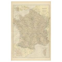
Antique Map of France, 1903, with Inset of Paris and Corsica
Acerca del artículo
Title: Antique Map of France, 1903, with Inset of Paris and Corsica
Description:
This antique map, titled "France," was engraved and published in 1903 by the renowned W. & A.K. Johnston firm in Edinburgh and London. It offers a comprehensive and meticulously detailed view of France at the turn of the 20th century, capturing both its diverse geography and its political organization.
The map features an intricate network of departments, with boundaries delicately shaded in pastel greens, pinks, yellows, and blues, making each region stand out with subtle elegance. Cities, towns, rivers, and mountain ranges are finely rendered, showcasing the exceptional craftsmanship and precision that Johnston maps are known for.
A standout feature of this map is its inset detailing the "Environs of Paris," providing an in-depth view of the French capital and its surrounding area. Another inset focuses on the island of Corsica, ensuring no part of the French Republic is left undocumented. The clear, crisp typography and fine linework highlight the map’s quality, while the soft color palette adds a refined aesthetic that complements both modern and traditional interiors.
For collectors and enthusiasts, this map offers more than geographic data—it’s a snapshot of France at a time when the country was a leading European power with a rich cultural and political heritage. It also reflects a period of modernization, with railways connecting even the remotest parts of the nation.
Condition report:
The map is in very good antique condition, with minimal foxing and light edge toning typical for its age. The colors remain vibrant and the paper is stable and well-preserved.
Framing tips:
A dark wooden frame, such as walnut or mahogany, will add warmth and sophistication to this map. Use a cream or off-white matting to highlight the soft pastel colors and intricate detail, making this a refined and elegant focal point in any room or office.
- Dimensiones:Altura: 36,8 cm (14,49 in)Anchura: 48 cm (18,9 in)Profundidad: 0,2 mm (0,01 in)
- Materiales y técnicas:
- Época:
- Fecha de fabricación:1903
- Estado:The map is in very good antique condition, with minor age-related foxing and slight edge toning typical for its vintage. The colors remain vibrant and the paper is stable and well-preserved. Folding line as issued.
- Ubicación del vendedor:Langweer, NL
- Número de referencia:Vendedor: BG-13577-91stDibs: LU3054345241512
Sobre el vendedor
5,0
Vendedor reconocido
Estos prestigiosos vendedores son líderes del sector y representan el escalón más alto en cuanto a calidad y diseño de artículos.
Vendedor Oro
Vendedores premium que mantienen una calificación de +4,3 y tiempos de respuesta de 24 horas
Establecido en 2009
Vendedor de 1stDibs desde 2017
2452 ventas en 1stDibs
Tiempo de respuesta usual: <1 hora
- EnvíoRecuperando presupuesto…Envío desde: Langweer, Países Bajos
- Política de devolución
Partes de esta página se han traducido automáticamente. 1stDibs no puede garantizar la exactitud de las traducciones. El inglés es el idioma predeterminado de este sitio web.
Garantía de autenticidad
En el improbable caso de que haya algún problema con la autenticidad de un artículo, ponte en contacto con nosotros en un plazo de 1 año para recibir un reembolso total. DetallesGarantía de devolución de dinero
Si tu artículo no es como se describe, sufre daños durante el transporte o no llega, ponte en contacto con nosotros en un plazo de 7 días para recibir un reembolso total. DetallesCancelación dentro de las 24 horas
Tienes un período de gracia de 24 horas para reconsiderar tu compra, sin preguntas.Vendedores profesionales aprobados
Nuestros vendedores de primera clase deben cumplir estrictos estándares de servicio para mantener la integridad de nuestros anuncios.Garantía de igualación de precios
Si encuentras que un vendedor publicó el mismo artículo por un precio menor en otro lado, igualaremos ese precio.Entrega global de confianza
Nuestra red de transporte de primera ofrece opciones de envío especializado en todo el mundo, que incluye envío personalizado.Más de este vendedor
Ver todoMapa Antiguo de Francia con Mapa Inserto de la Isla de Córcega, 1820
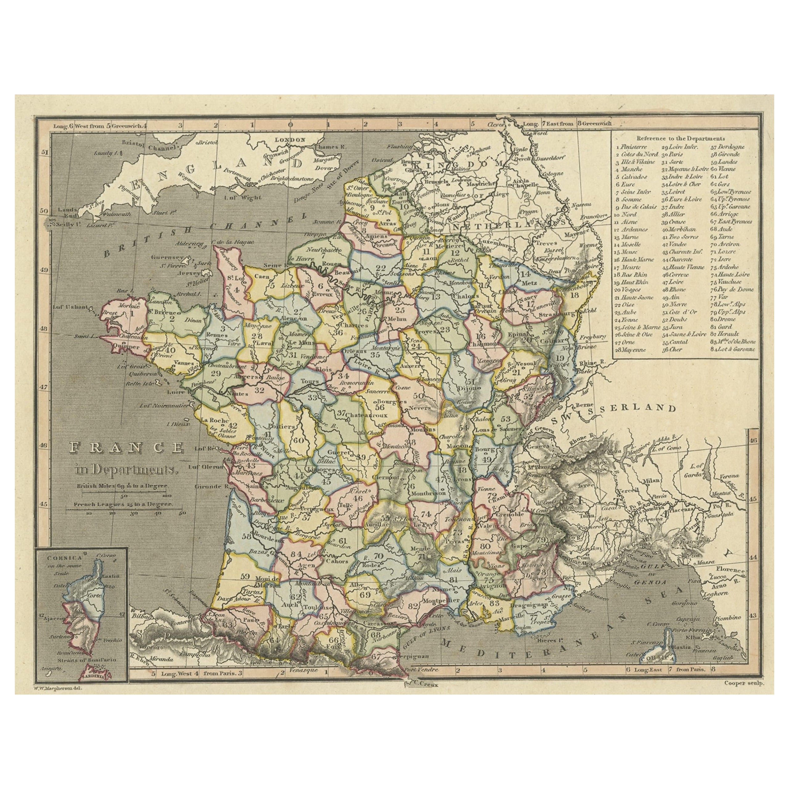
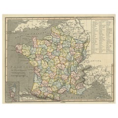
Mapa antiguo titulado "Francia en Departamentos". Antiguo mapa de Francia, con un pequeño mapa de la isla de Córcega. Incluye una tabla con referencias a los departamentos.
Artis...
Categoría
Antiguo, siglo XIX, Mapas
Materiales
Papel
241 US$ Precio de venta
Descuento del 20 %
Mapa antiguo de Francia con un mapa de la isla de Córcega, c.1820
Mapa antiguo titulado "Frankrijk naar de nieuwste bepalingen meerendeels gevolgd naar Lapie". Precioso mapa de Francia con un mapa inserto de la isla de Córcega. Incluye una tabla co...
Categoría
Antiguo, siglo XIX, Mapas
Materiales
Papel

166 US$ Precio de venta
Descuento del 20 %
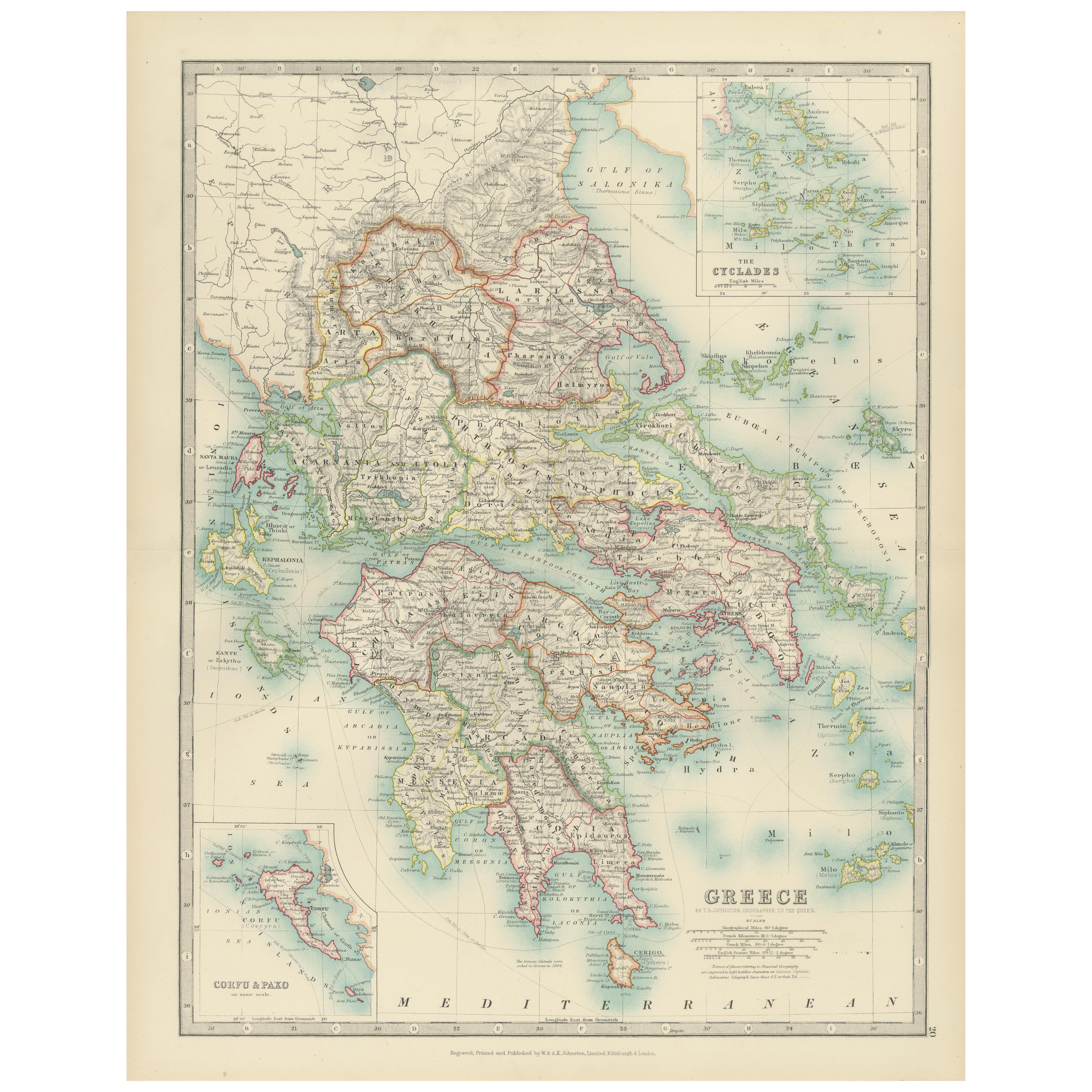
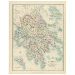
Antique Map of Greece and the Cyclades, 1903, with Many Details and Inset Maps
Title: Antique Map of Greece and the Cyclades, 1903, with Intricate Detail and Inset Maps
Description: This antique map, titled "Greece with Its Islands, Including the Cyclades," wa...
Categoría
principios del siglo XX, Mapas
Materiales
Papel
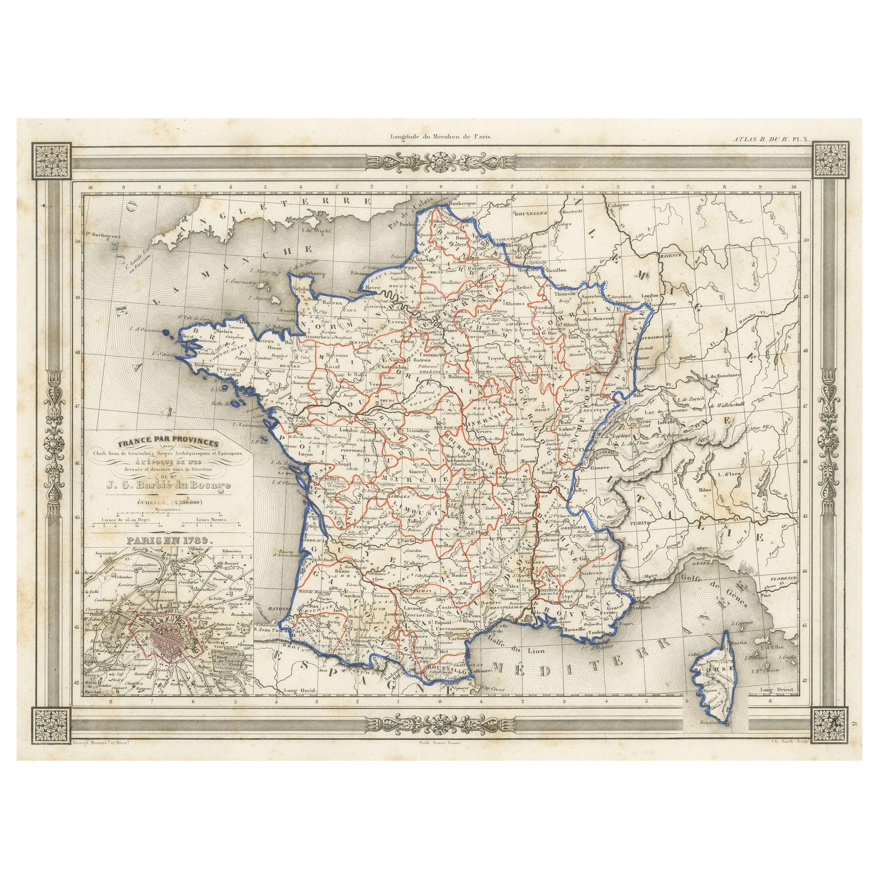
Mapa antiguo de Francia en Provincias, con recuadro de París
Mapa antiguo titulado "France par Provinces". Mapa original antiguo de Francia en Provincias. Abarca desde Flandes, al norte, hasta el Rosellón, al sur, y desde Bretaña, al oeste, ha...
Categoría
Antiguo, Mediados del siglo XIX, Mapas
Materiales
Papel

102 US$ Precio de venta
Descuento del 20 %
Mapa de Francia de 1882 en el que se destacan los límites políticos, las ciudades y las inserciones de Córcega
Este mapa de Francia de 1882, publicado por Blackie and Son como parte del "Atlas y Geografía Completos del Mundo", ofrece una descripción detallada del país a finales del siglo XIX....
Categoría
Antiguo, Década de 1880, Mapas
Materiales
Papel
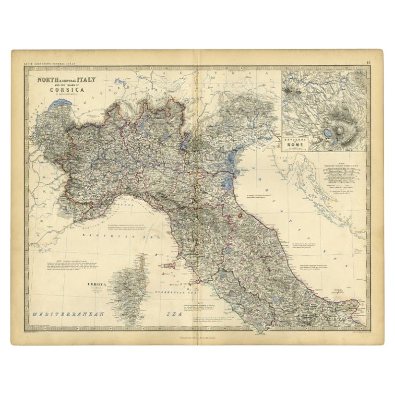
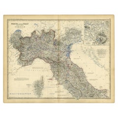
Mapa antiguo de Italia y Córcega, c.1860
Mapa antiguo titulado "Italia Septentrional y Central e Isla de Córcega".
Mapa antiguo del norte y centro de Italia, y de la isla de Córcega. Con un mapa de la región de Roma. Pr...
Categoría
Antiguo, siglo XIX, Mapas
Materiales
Papel
102 US$ Precio de venta
Descuento del 20 %
También te puede gustar
Mapa original antiguo del estado norteamericano de Minnesota, 1903
Mapa antiguo de Minnesota
Publicado por A & C Black. 1903
Color original
Buen estado
Sin enmarcar.
Envío gratuito
Categoría
Antiguo, Principios del 1900, Inglés, Mapas
Materiales
Papel

Mapa original antiguo del estado norteamericano de Alabama, 1903
Antique map of Alabama
Published By A & C Black. 1903
Original colour
Good condition
Unframed.
Free shipping
Categoría
Antiguo, Principios del 1900, Inglés, Mapas
Materiales
Papel

Mapa original antiguo del estado norteamericano de Alaska, 1903
Mapa antiguo de Alaska
Publicado por A & C Black. 1903
Color original
Buen estado
Sin enmarcar.
Envío gratuito
Categoría
Antiguo, Principios del 1900, Inglés, Mapas
Materiales
Papel

Mapa original antiguo del estado norteamericano de Nebraska, 1903
Mapa antiguo de Nebraska
Publicado por A & C Black. 1903
Color original
Buen estado
Sin enmarcar.
Envío gratuito
Categoría
Antiguo, Principios del 1900, Inglés, Mapas
Materiales
Papel

Mapa Antiguo Original del Estado Americano de Washington, 1903
Mapa antiguo de Washington
Publicado por A & C Black. 1903
Color original
Buen estado
Sin enmarcar.
Envío gratuito
Categoría
Antiguo, Principios del 1900, Inglés, Mapas
Materiales
Papel

Mapa original antiguo del estado norteamericano de Tennessee, 1903
Antique map of Tennessee
Published By A & C Black. 1903
Original colour
Good condition
Unframed.
Free shipping
Categoría
Antiguo, Principios del 1900, Inglés, Mapas
Materiales
Papel
