Artículos similares a Antique Map of Greece and the Cyclades, 1903, with Many Details and Inset Maps


¿Quieres más imágenes o vídeos?
Solicita imágenes o vídeos adicionales al vendedor
1 de 10
Antique Map of Greece and the Cyclades, 1903, with Many Details and Inset Maps
Acerca del artículo
Title: Antique Map of Greece and the Cyclades, 1903, with Intricate Detail and Inset Maps
Description: This antique map, titled "Greece with Its Islands, Including the Cyclades," was engraved and published in 1903 by W. & A.K. Johnston in Edinburgh and London. It provides an exquisite depiction of Greece and its surrounding islands, capturing the stunning geography and complex political landscape of this historically rich region at the start of the 20th century.
The map’s delicate pastel coloring in shades of pink, green, and yellow highlights the boundaries of Greek provinces, showing major cities, rivers, and mountain ranges with precision and clarity. Key areas such as the Peloponnese, Thessaly, Epirus, and Central Greece are detailed, offering insight into a landscape shaped by millennia of history and mythology.
Inset maps of Corfu & Paxo and the Cyclades offer additional detail, emphasizing the maritime and cultural importance of these islands in the Aegean and Ionian Seas. The Cyclades inset, in particular, is a visual highlight, capturing the unique charm and interconnectedness of these legendary islands.
For collectors, historians, and lovers of Greek culture, this map is more than a decorative item—it is a portal into the classical and modern heritage of Greece. It reflects a time of national revival and modernization, when Greece was emerging as a unified state with a proud and storied past.
Condition report:
This map is in very good antique condition, with slight foxing and gentle toning around the edges typical for its age. The colors remain vibrant and the paper is well-preserved.
Framing tips:
A classic wooden frame in dark walnut or cherry will add warmth and sophistication to this piece. Use a cream or off-white matting to highlight the pastel coloring and detailed engraving, creating a timeless and elegant focal point for any space.
- Dimensiones:Altura: 36,8 cm (14,49 in)Anchura: 47 cm (18,51 in)Profundidad: 0,2 mm (0,01 in)
- Materiales y técnicas:
- Época:
- Fecha de fabricación:1903
- Estado:The map is in very good antique condition, with minor foxing and gentle toning at the edges typical for its age. The colors remain vibrant and the paper well-preserved. Folding line as issued.
- Ubicación del vendedor:Langweer, NL
- Número de referencia:Vendedor: BG-13577-201stDibs: LU3054345242952
Sobre el vendedor
5,0
Vendedor reconocido
Estos prestigiosos vendedores son líderes del sector y representan el escalón más alto en cuanto a calidad y diseño de artículos.
Vendedor Oro
Vendedores premium que mantienen una calificación de +4,3 y tiempos de respuesta de 24 horas
Establecido en 2009
Vendedor de 1stDibs desde 2017
2446 ventas en 1stDibs
Tiempo de respuesta usual: 1 hora
- EnvíoRecuperando presupuesto…Envío desde: Langweer, Países Bajos
- Política de devolución
Partes de esta página se han traducido automáticamente. 1stDibs no puede garantizar la exactitud de las traducciones. El inglés es el idioma predeterminado de este sitio web.
Garantía de autenticidad
En el improbable caso de que haya algún problema con la autenticidad de un artículo, ponte en contacto con nosotros en un plazo de 1 año para recibir un reembolso total. DetallesGarantía de devolución de dinero
Si tu artículo no es como se describe, sufre daños durante el transporte o no llega, ponte en contacto con nosotros en un plazo de 7 días para recibir un reembolso total. DetallesCancelación dentro de las 24 horas
Tienes un período de gracia de 24 horas para reconsiderar tu compra, sin preguntas.Vendedores profesionales aprobados
Nuestros vendedores de primera clase deben cumplir estrictos estándares de servicio para mantener la integridad de nuestros anuncios.Garantía de igualación de precios
Si encuentras que un vendedor publicó el mismo artículo por un precio menor en otro lado, igualaremos ese precio.Entrega global de confianza
Nuestra red de transporte de primera ofrece opciones de envío especializado en todo el mundo, que incluye envío personalizado.Más de este vendedor
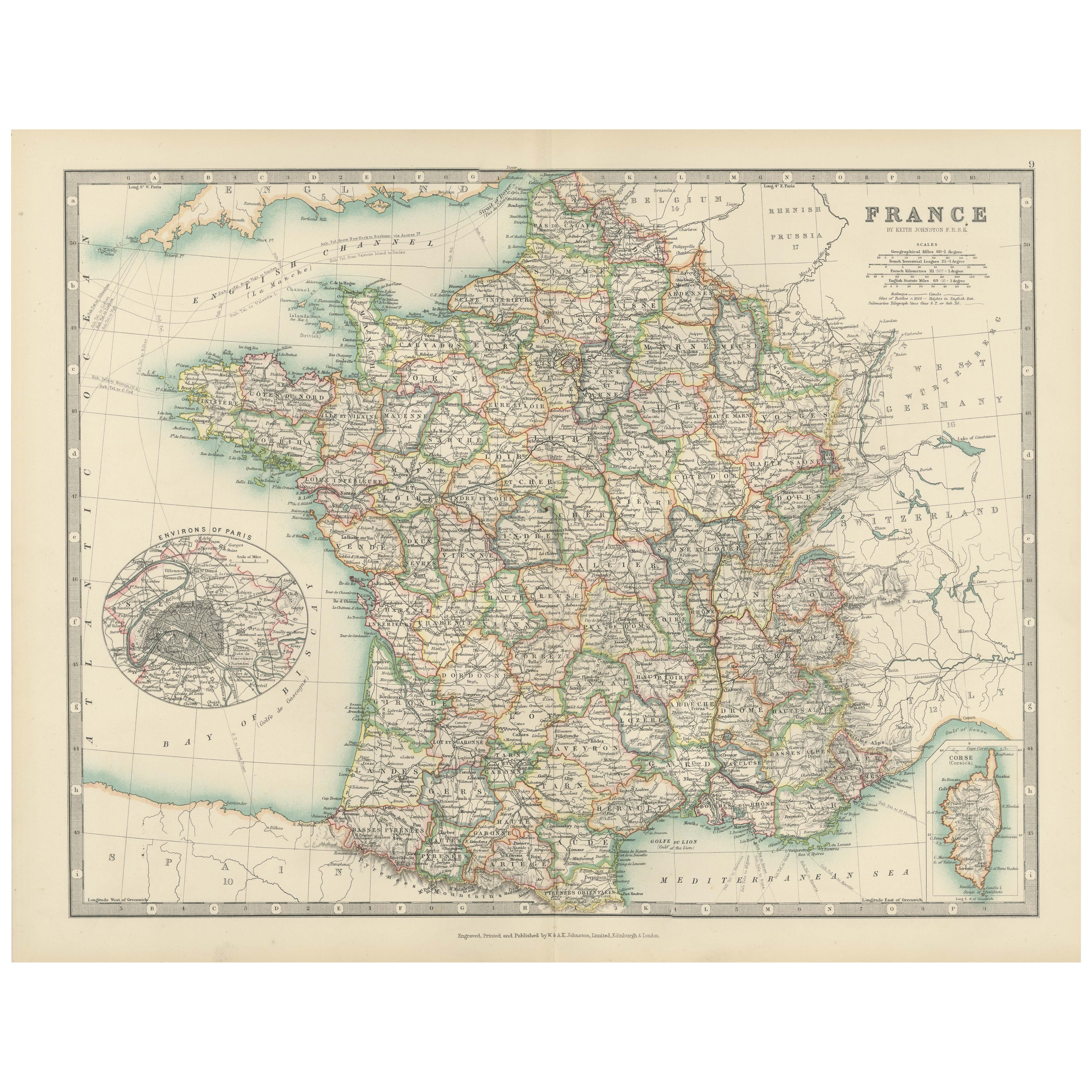
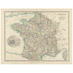
Ver todoAntique Map of France, 1903, with Inset of Paris and Corsica
Title: Antique Map of France, 1903, with Inset of Paris and Corsica
Description:
This antique map, titled "France," was engraved and published in 1903 by the renowned W. & A.K. John...
Categoría
principios del siglo XX, Mapas
Materiales
Papel
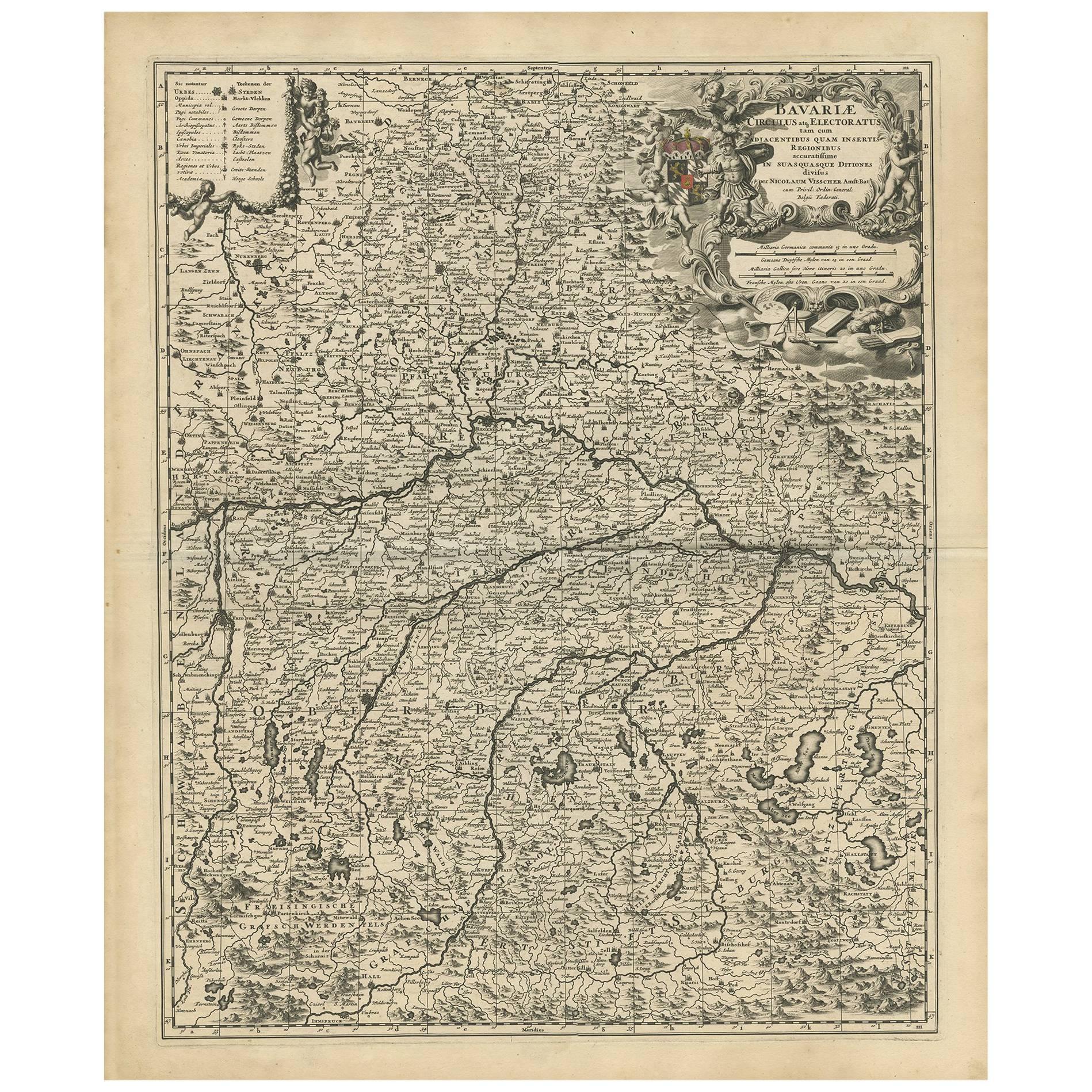
Mapa antiguo de Baviera con muchos detalles, Alemania
Mapa antiguo titulado "Bavariae Circulus atq Electoratus tam cum Adiacentibus quam insertis Regionibus (..)". Mapa holandés de Baviera, que muestra las numerosas ciudades, pueblos y ...
Categoría
Antiguo, finales del siglo XVII, Mapas
Materiales
Papel
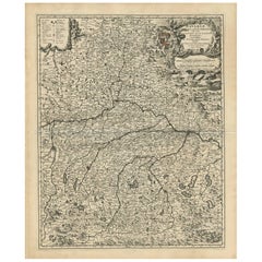
615 US$ Precio de venta
Descuento del 20 %
Mapa antiguo de Grecia con un mapa en recuadro de la región del Alto Danubio, c.1720
Mapa antiguo titulado "Fluviorum in Europa principis Danubii cum adiacentibus Regnis".
Mapa detallado de Grecia, los Balcanes y las partes contiguas de los mares Adriático y Egeo. ...
Categoría
Antiguo, siglo XVIII, Mapas
Materiales
Papel

698 US$ Precio de venta
Descuento del 20 %
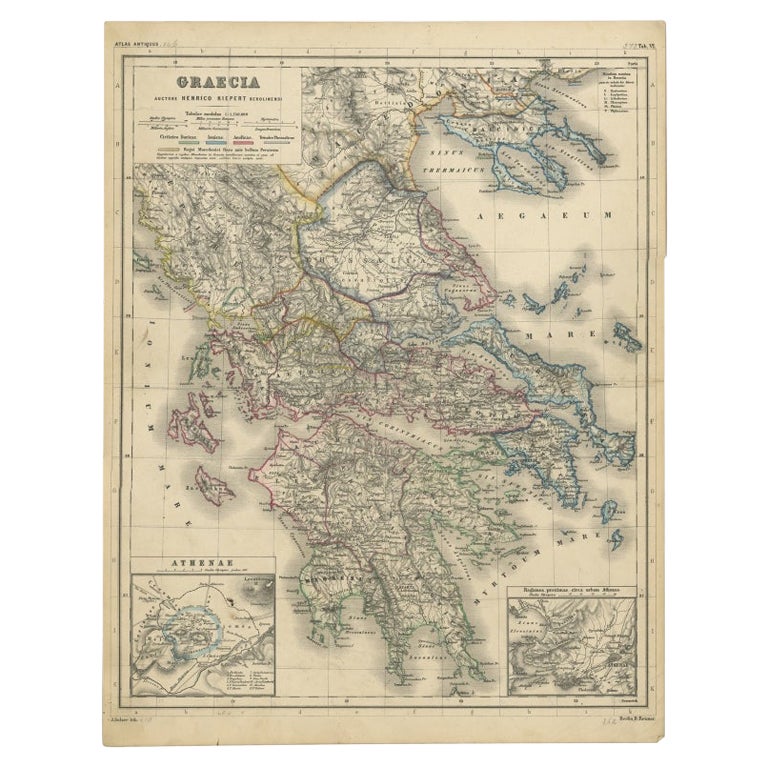
Mapa antiguo de Grecia con dos pequeños mapas de Atenas, c.1870
Mapa antiguo titulado "Graecia". Antiguo mapa de Grecia con dos pequeños mapas de Atenas. Este mapa procede del "Atlas Antiquus, twaalf kaarten behoorende bij de Oude Geschiedenis". ...
Categoría
Antiguo, siglo XIX, Mapas
Materiales
Papel

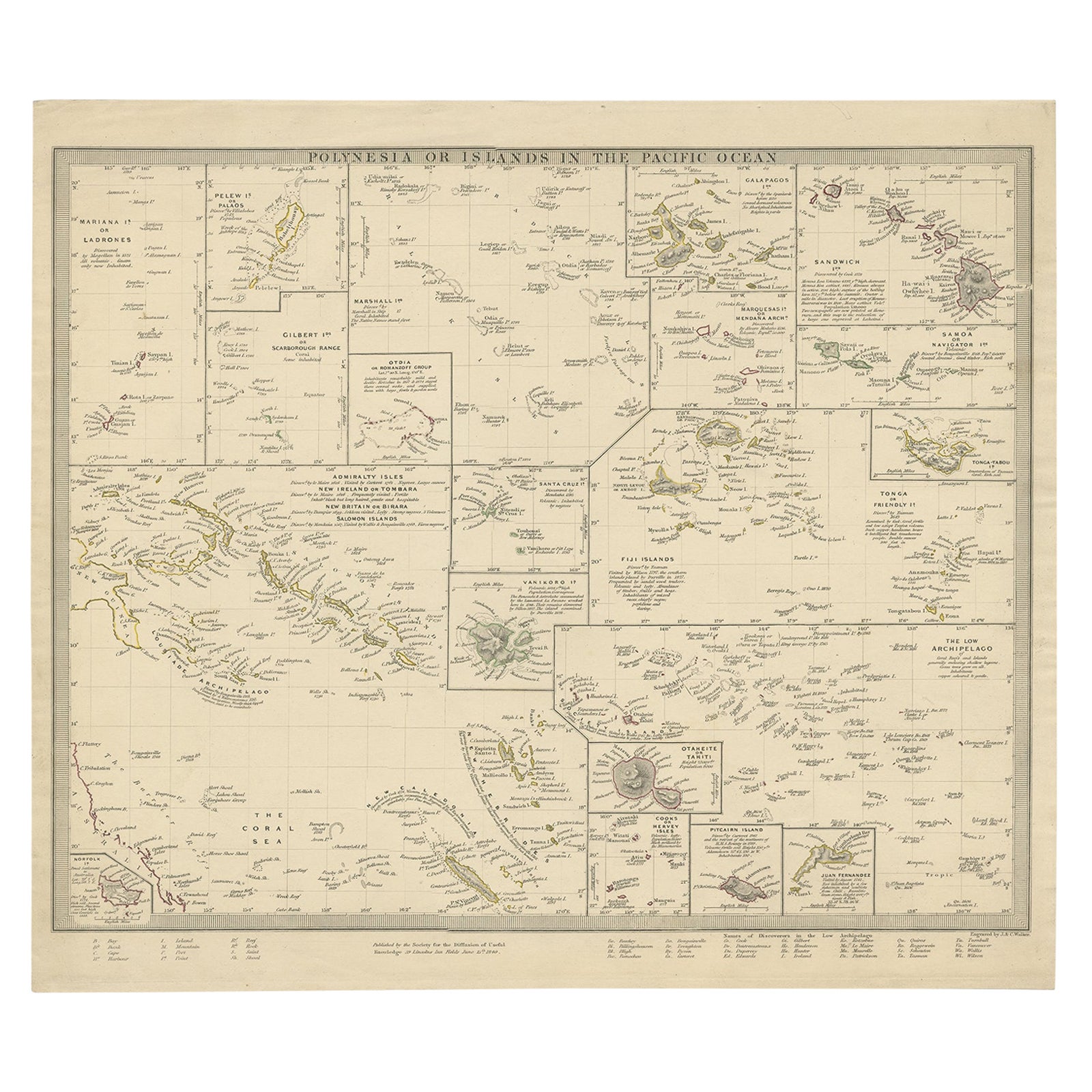
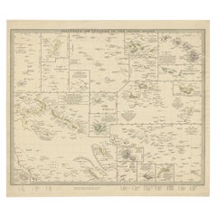
Mapa antiguo de Polinesia con detalles de muchas islas, 1840
Mapa antiguo titulado "Polinesia o Islas del Océano Pacífico".
Este mapa representa varias islas, como el Archipiélago de las Lousiade, Tahití, la Isla Pitcairn, Juan Fernández, el...
Categoría
Antiguo, siglo XIX, Mapas
Materiales
Papel
Antique Map of Southern Scotland, 1903, with Coastal and Inland Details
Title: Antique Map of Southern Scotland, 1903, with Coastal and Inland Details
Description:
This exquisite antique map, titled "Scotland (Southern Sheet I)," was engraved and publis...
Categoría
principios del siglo XX, Mapas
Materiales
Papel

También te puede gustar
Mapa original antiguo del estado norteamericano de Tennessee, 1903
Antique map of Tennessee
Published By A & C Black. 1903
Original colour
Good condition
Unframed.
Free shipping
Categoría
Antiguo, Principios del 1900, Inglés, Mapas
Materiales
Papel

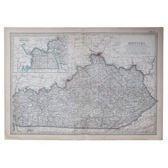
Mapa original antiguo del estado norteamericano de Kentucky, 1903
Mapa antiguo de Kentucky
Publicado por A & C Black. 1903
Color original
Buen estado
Sin enmarcar.
Envío gratuito
Categoría
Antiguo, Principios del 1900, Inglés, Mapas
Materiales
Papel
Mapa original antiguo del estado norteamericano de Mississippi, 1903
Mapa antiguo de Mississippi
Publicado por A & C Black. 1903
Color original
Buen estado
Sin enmarcar.
Envío gratuito
Categoría
Antiguo, Principios del 1900, Inglés, Mapas
Materiales
Papel

Mapa original antiguo del estado norteamericano de Massachusetts, 1903
Antique map of Vermont and New Hampshire
Published By A & C Black. 1903
Original colour
Good condition
Unframed.
Free shipping
Categoría
Antiguo, Principios del 1900, Inglés, Mapas
Materiales
Papel

Mapa original antiguo del estado norteamericano de Alabama, 1903
Antique map of Alabama
Published By A & C Black. 1903
Original colour
Good condition
Unframed.
Free shipping
Categoría
Antiguo, Principios del 1900, Inglés, Mapas
Materiales
Papel

Mapa original antiguo del estado norteamericano de Luisiana, 1903
Mapa antiguo de Luisiana
Publicado por A & C Black. 1903
Color original
Buen estado
Sin enmarcar.
Envío gratuito
Categoría
Antiguo, Principios del 1900, Inglés, Mapas
Materiales
Papel
