Artículos similares a Antique Map of Ireland, 1903, with Intricate County Boundaries & Coastal Details


¿Quieres más imágenes o vídeos?
Solicita imágenes o vídeos adicionales al vendedor
1 de 10
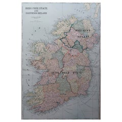
Antique Map of Ireland, 1903, with Intricate County Boundaries & Coastal Details
Acerca del artículo
Title: Antique Map of Ireland, 1903, with Intricate County Boundaries and Coastal Detail
Description:
This antique map of Ireland, engraved and published in 1903 by the esteemed W. & A.K. Johnston firm in Edinburgh and London, is a beautifully detailed portrayal of the Emerald Isle. It offers a fascinating snapshot of Ireland’s political and geographical landscape at the turn of the 20th century.
The map captures the entire island of Ireland with exceptional clarity, extending from the rugged coastlines of Donegal in the north to the sun-warmed shores of Cork and Kerry in the south. Delicately colored in soft pastels of green, pink, and yellow, it highlights the various counties and their administrative boundaries. Rivers, mountain ranges, and major cities such as Dublin, Belfast, and Cork are all meticulously documented, reflecting the cartographic precision of Johnston’s work.
Of particular interest are the intricate networks of railways and roads that connect the towns and villages, illustrating the early 20th-century infrastructure that helped shape the social and economic fabric of Ireland. The inclusion of historical province names—Ulster, Leinster, Munster, and Connaught—adds an extra layer of cultural context, evoking Ireland’s rich and complex history.
For collectors, historians, and lovers of Irish heritage, this map is more than just a beautiful artifact. It is a tangible record of Ireland during a time of significant social and political change, just before the transformative events of the Irish struggle for independence. Its soft coloring and fine engraving make it a stunning decorative piece that also sparks historical curiosity.
Condition report:
The map is in very good antique condition, with minor age-related foxing and slight edge toning typical for its vintage. The colors remain vibrant and the paper is stable and well-preserved.
Framing tips:
A classic wooden frame in walnut or oak will bring warmth and elegance to this map. Pair with a cream or off-white matting to accentuate the pastel coloring and delicate detail, creating a timeless and sophisticated display perfect for any home or office.
- Dimensiones:Altura: 36,8 cm (14,49 in)Anchura: 48 cm (18,9 in)Profundidad: 0,2 mm (0,01 in)
- Materiales y técnicas:
- Época:
- Fecha de fabricación:1903
- Estado:The map is in very good antique condition, with minor age-related foxing and slight edge toning typical for its vintage. The colors remain vibrant and the paper is stable and well-preserved. Folding line as issued.
- Ubicación del vendedor:Langweer, NL
- Número de referencia:Vendedor: BG-13577-81stDibs: LU3054345241432
Sobre el vendedor
5,0
Vendedor reconocido
Estos prestigiosos vendedores son líderes del sector y representan el escalón más alto en cuanto a calidad y diseño de artículos.
Vendedor Oro
Vendedores premium que mantienen una calificación de +4,3 y tiempos de respuesta de 24 horas
Establecido en 2009
Vendedor de 1stDibs desde 2017
2452 ventas en 1stDibs
Tiempo de respuesta usual: <1 hora
- EnvíoRecuperando presupuesto…Envío desde: Langweer, Países Bajos
- Política de devolución
Partes de esta página se han traducido automáticamente. 1stDibs no puede garantizar la exactitud de las traducciones. El inglés es el idioma predeterminado de este sitio web.
Garantía de autenticidad
En el improbable caso de que haya algún problema con la autenticidad de un artículo, ponte en contacto con nosotros en un plazo de 1 año para recibir un reembolso total. DetallesGarantía de devolución de dinero
Si tu artículo no es como se describe, sufre daños durante el transporte o no llega, ponte en contacto con nosotros en un plazo de 7 días para recibir un reembolso total. DetallesCancelación dentro de las 24 horas
Tienes un período de gracia de 24 horas para reconsiderar tu compra, sin preguntas.Vendedores profesionales aprobados
Nuestros vendedores de primera clase deben cumplir estrictos estándares de servicio para mantener la integridad de nuestros anuncios.Garantía de igualación de precios
Si encuentras que un vendedor publicó el mismo artículo por un precio menor en otro lado, igualaremos ese precio.Entrega global de confianza
Nuestra red de transporte de primera ofrece opciones de envío especializado en todo el mundo, que incluye envío personalizado.Más de este vendedor
Ver todoAntique Map of Europe, 1903, with Intricate Political Boundaries and Rich Detail
Title: Antique Map of Europe, 1903, with Intricate Political Boundaries and Rich Detail
Description:
This antique map, titled "Europe," is a finely engraved and beautifully colored ...
Categoría
principios del siglo XX, Mapas
Materiales
Papel

Antique Map of Asia with Intricate Provincial Boundaries, Published in 1903
Title: Antique Map of Asia, 1903, with Intricate Provincial Boundaries and Coastal Features
Description:
This antique map, titled "Asia," was engraved and published in 1903 by the r...
Categoría
principios del siglo XX, Mapas
Materiales
Papel

Antique Map of the German Empire, 1903, with Intricate Provincial Boundaries
Title: Antique Map of the German Empire, 1903, with Intricate Provincial Boundaries
Description:
This antique map, titled "Empire of Germany (Southern Portion)," was engraved and pu...
Categoría
principios del siglo XX, Mapas
Materiales
Papel

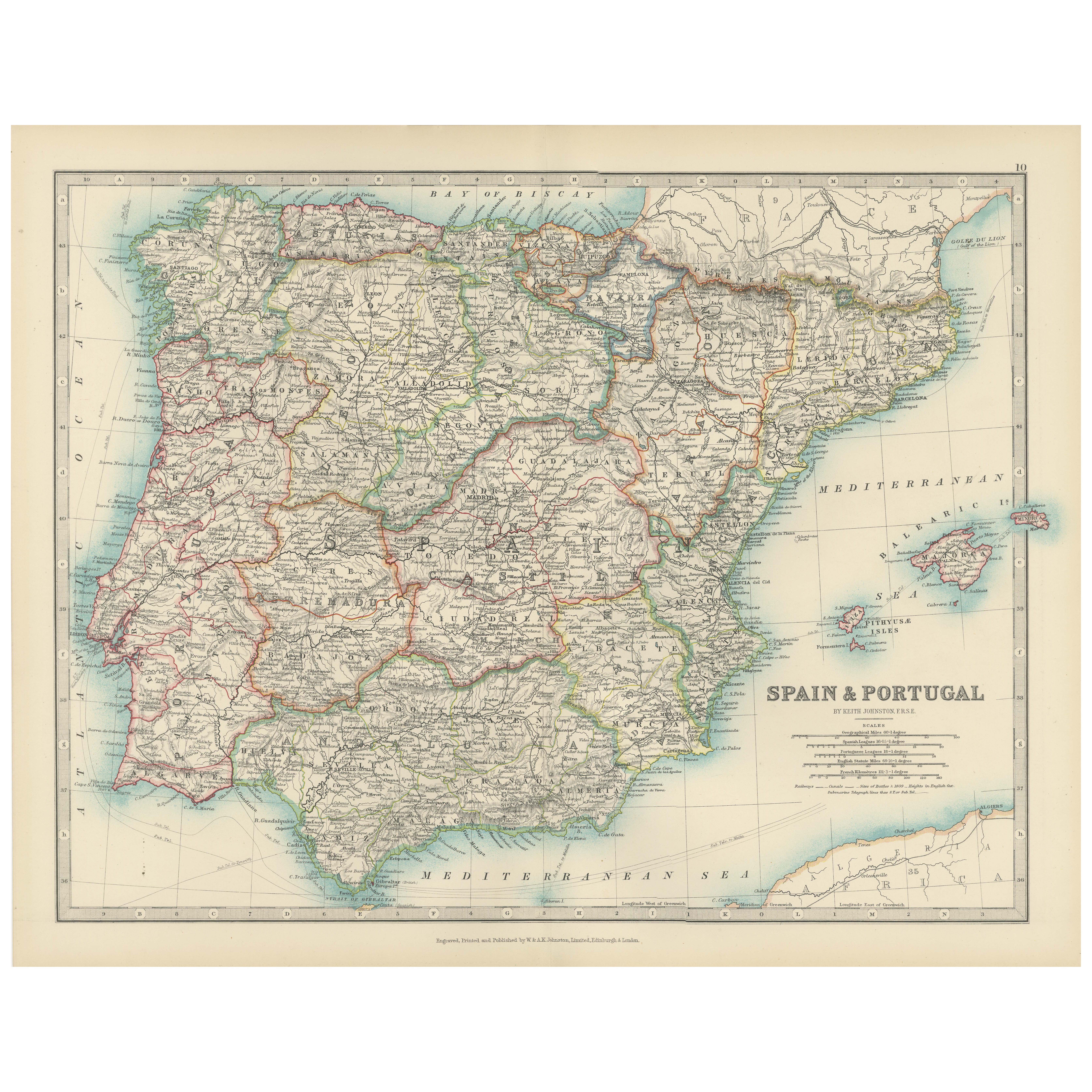
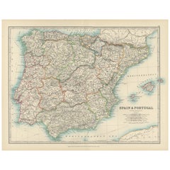
Antique Map of Spain and Portugal, 1903, Regional Boundaries and Coastal Detail
Antique Map of Spain and Portugal, 1903, Featuring Regional Boundaries and Coastal Detail
Description: This antique map, titled "Spain & Portugal," was engraved and published in 190...
Categoría
principios del siglo XX, Mapas
Materiales
Papel
Antique Map of Northern Scotland, 1903, with Intricate Coastal Features
Title: Antique Map of Northern Scotland and Islands, 1903, with Intricate Coastal Features
Description:
This striking antique map, titled "Scotland (Northern Sheet I)," was engraved...
Categoría
principios del siglo XX, Mapas
Materiales
Papel

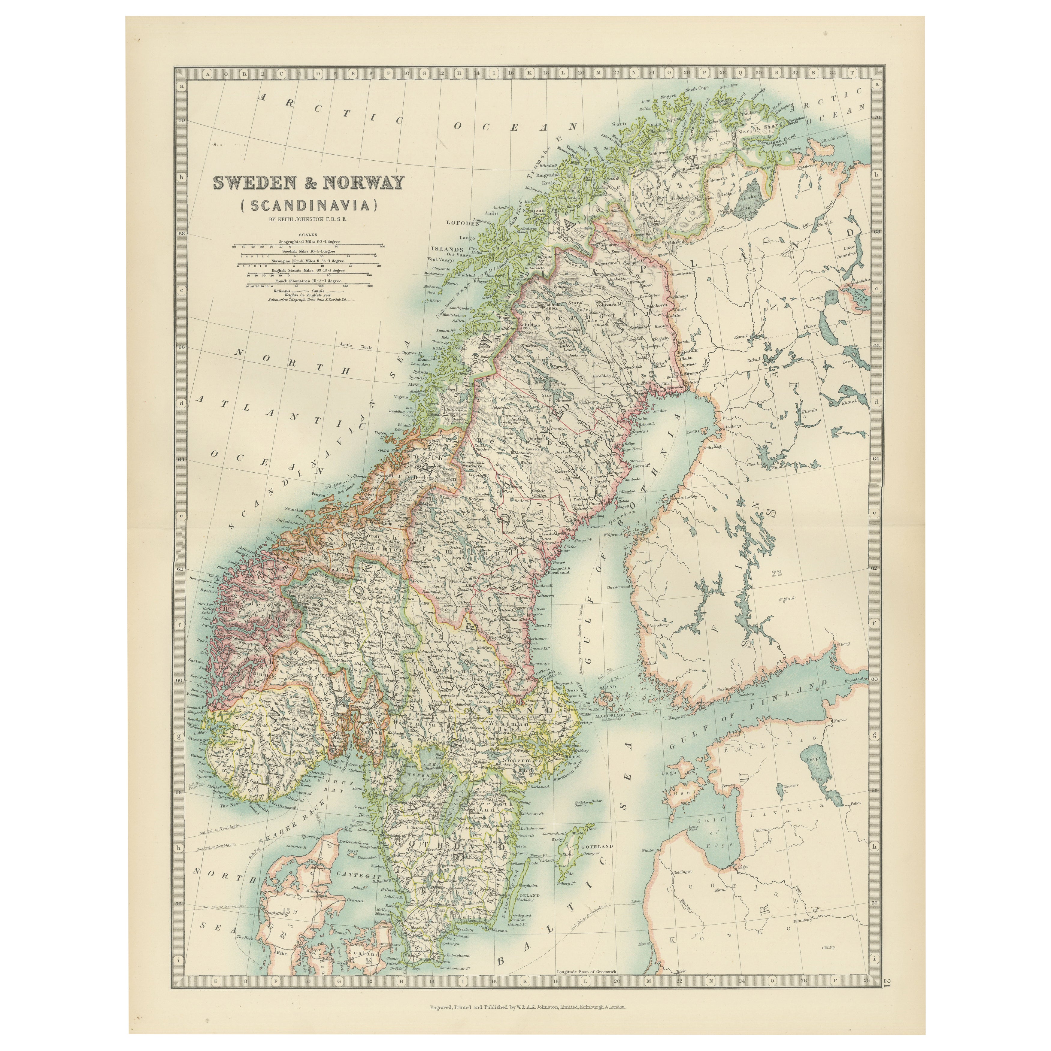
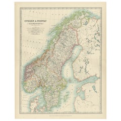
Antique Map of Sweden & Norway, 1903, with Intricate Topographical Detail
Title: Antique Map of Sweden & Norway, 1903, with Intricate Topographical Detail
Description:
This antique map, titled "Sweden & Norway (Scandinavia)," was engraved and published in...
Categoría
principios del siglo XX, Mapas
Materiales
Papel
También te puede gustar
Mapa original antiguo de Irlanda - Kerry. C.1840
Gran mapa de Kerry
Grabado en acero
Dibujado bajo la dirección de A.Adlard
Publicado por How y Parsons, C.1840
Sin enmarcar.
Categoría
Antiguo, Década de 1840, Inglés, Mapas
Materiales
Papel

Gran Mapa Antiguo Original de Irlanda. C.1900
Fabuloso mapa de Irlanda
Color original.
Grabado e impreso por la George F. Cram Company, Indianápolis.
Publicado, C.1900.
Sin enmarcar.
Envío gratuito.
Categoría
Antiguo, Década de 1890, Estadounidense, Mapas
Materiales
Papel
Mapa original antiguo del estado norteamericano de Minnesota, 1903
Mapa antiguo de Minnesota
Publicado por A & C Black. 1903
Color original
Buen estado
Sin enmarcar.
Envío gratuito
Categoría
Antiguo, Principios del 1900, Inglés, Mapas
Materiales
Papel

Mapa original antiguo del estado norteamericano de Alabama, 1903
Antique map of Alabama
Published By A & C Black. 1903
Original colour
Good condition
Unframed.
Free shipping
Categoría
Antiguo, Principios del 1900, Inglés, Mapas
Materiales
Papel

Mapa original antiguo del estado norteamericano de Alaska, 1903
Mapa antiguo de Alaska
Publicado por A & C Black. 1903
Color original
Buen estado
Sin enmarcar.
Envío gratuito
Categoría
Antiguo, Principios del 1900, Inglés, Mapas
Materiales
Papel

Mapa original antiguo del estado norteamericano de Nebraska, 1903
Mapa antiguo de Nebraska
Publicado por A & C Black. 1903
Color original
Buen estado
Sin enmarcar.
Envío gratuito
Categoría
Antiguo, Principios del 1900, Inglés, Mapas
Materiales
Papel
