Artículos similares a Antique Map of Northern India, Featuring Boundaries & Himalayan Detail, 1903


¿Quieres más imágenes o vídeos?
Solicita imágenes o vídeos adicionales al vendedor
1 de 10
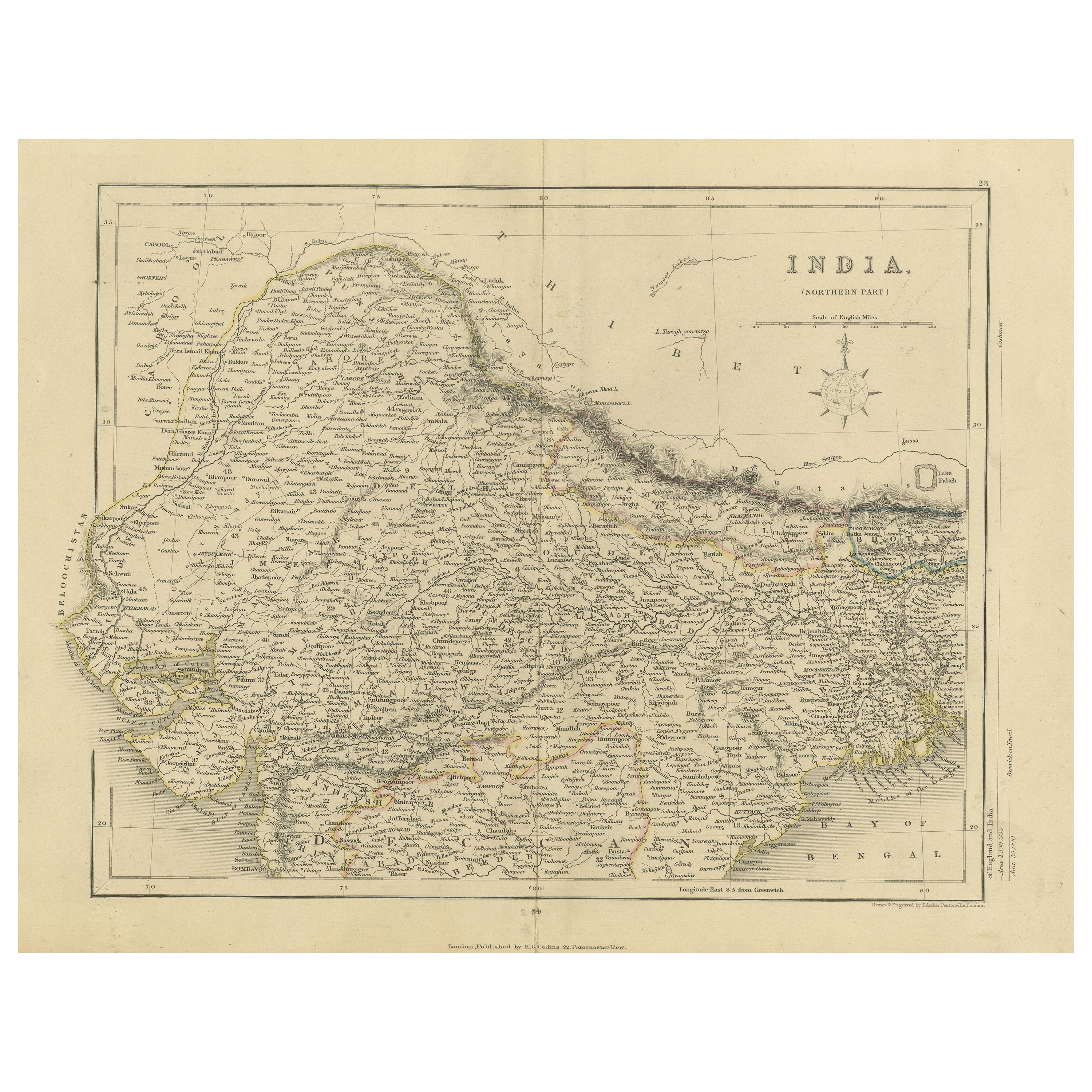
Antique Map of Northern India, Featuring Boundaries & Himalayan Detail, 1903
Acerca del artículo
Antique Map of Northern India, 1903, Featuring Provincial Boundaries and Himalayan Detail
This antique map, titled "India (Northern Sheet)," was engraved and published in 1903 by W. & A.K. Johnston in Edinburgh and London. It offers an intricate depiction of the northern regions of India at the dawn of the 20th century, capturing the country’s rich geographical and political complexity during a period of British colonial rule.
The map is delicately colored in pastel shades to highlight provincial and state boundaries, extending from the lush plains of the Ganges basin to the dramatic heights of the Himalayas. Major cities, rivers, mountain ranges, and railway lines are all clearly marked, offering a fascinating look at a time when India’s colonial infrastructure was rapidly expanding and reshaping the subcontinent.
From the culturally vibrant cities of Delhi, Lahore, and Calcutta to the remote passes and valleys of Tibet, this map captures the dynamic interplay between natural beauty and human endeavor. The careful typography and precision of Johnston’s cartography provide a clear and elegant window into this vast and diverse landscape.
For collectors, historians, and those with a deep interest in Indian history, this map is more than a decorative piece—it is a reflection of an era of both ambition and change. It highlights the enduring complexity of India’s natural and cultural environments, set against the backdrop of empire and exploration.
Condition report:
This map is in very good antique condition, with minor foxing and gentle edge toning typical for its age. The colors remain vibrant and the paper is stable and well-preserved.
Framing tips:
A classic dark wood frame in walnut or mahogany will enhance the warm pastel tones and the historical richness of the map. Use a cream or light tan matting to highlight the delicate linework and create an elegant, timeless focal point for any home, library, or study.
- Dimensiones:Altura: 36,8 cm (14,49 in)Anchura: 47 cm (18,51 in)Profundidad: 0,2 mm (0,01 in)
- Materiales y técnicas:
- Época:
- Fecha de fabricación:1903
- Estado:This map is in very good antique condition, with minor foxing and gentle edge toning typical for its age. The colors remain vibrant and the paper is stable and well-preserved. Folding line as issued.
- Ubicación del vendedor:Langweer, NL
- Número de referencia:Vendedor: BG-13577-281stDibs: LU3054345262532
Sobre el vendedor
5,0
Vendedor reconocido
Estos prestigiosos vendedores son líderes del sector y representan el escalón más alto en cuanto a calidad y diseño de artículos.
Vendedor Oro
Vendedores premium que mantienen una calificación de +4,3 y tiempos de respuesta de 24 horas
Establecido en 2009
Vendedor de 1stDibs desde 2017
2452 ventas en 1stDibs
Tiempo de respuesta usual: <1 hora
- EnvíoRecuperando presupuesto…Envío desde: Langweer, Países Bajos
- Política de devolución
Partes de esta página se han traducido automáticamente. 1stDibs no puede garantizar la exactitud de las traducciones. El inglés es el idioma predeterminado de este sitio web.
Garantía de autenticidad
En el improbable caso de que haya algún problema con la autenticidad de un artículo, ponte en contacto con nosotros en un plazo de 1 año para recibir un reembolso total. DetallesGarantía de devolución de dinero
Si tu artículo no es como se describe, sufre daños durante el transporte o no llega, ponte en contacto con nosotros en un plazo de 7 días para recibir un reembolso total. DetallesCancelación dentro de las 24 horas
Tienes un período de gracia de 24 horas para reconsiderar tu compra, sin preguntas.Vendedores profesionales aprobados
Nuestros vendedores de primera clase deben cumplir estrictos estándares de servicio para mantener la integridad de nuestros anuncios.Garantía de igualación de precios
Si encuentras que un vendedor publicó el mismo artículo por un precio menor en otro lado, igualaremos ese precio.Entrega global de confianza
Nuestra red de transporte de primera ofrece opciones de envío especializado en todo el mundo, que incluye envío personalizado.Más de este vendedor
Ver todoAntique Map of Ireland, 1903, with Intricate County Boundaries & Coastal Details
Title: Antique Map of Ireland, 1903, with Intricate County Boundaries and Coastal Detail
Description:
This antique map of Ireland, engraved and published in 1903 by the esteemed W. ...
Categoría
principios del siglo XX, Mapas
Materiales
Papel

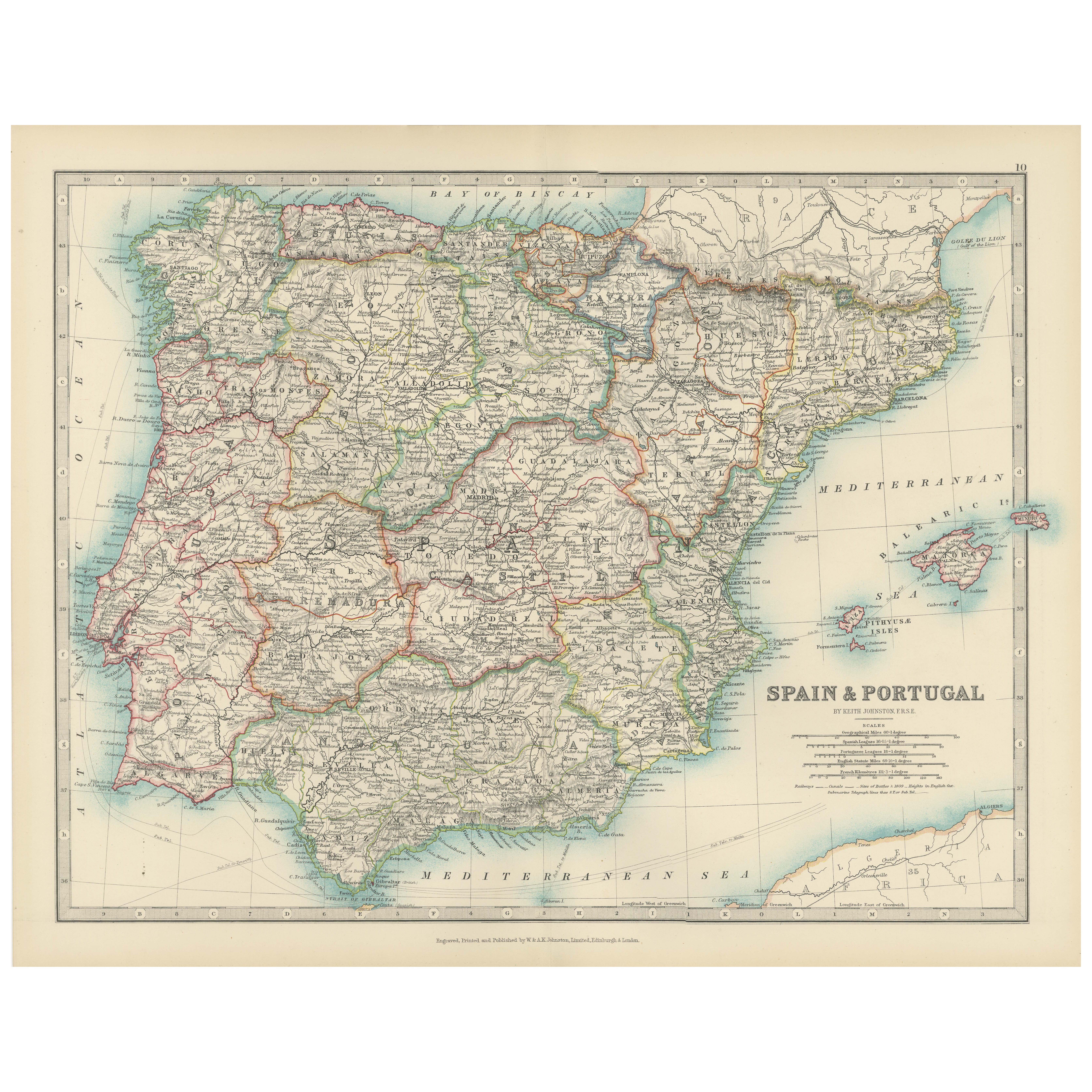
Antique Map of Spain and Portugal, 1903, Regional Boundaries and Coastal Detail
Antique Map of Spain and Portugal, 1903, Featuring Regional Boundaries and Coastal Detail
Description: This antique map, titled "Spain & Portugal," was engraved and published in 190...
Categoría
principios del siglo XX, Mapas
Materiales
Papel
Antique Map of Europe, 1903, with Intricate Political Boundaries and Rich Detail
Title: Antique Map of Europe, 1903, with Intricate Political Boundaries and Rich Detail
Description:
This antique map, titled "Europe," is a finely engraved and beautifully colored ...
Categoría
principios del siglo XX, Mapas
Materiales
Papel

Mapa original antiguo del norte de la India
Por Jakob van der Schley
Mapa antiguo titulado "Carte de l'Indoustan (..) - Kaart van Hindoestan (..)". Mapa antiguo original del norte de la India. Este mapa procede de "Historische beschryving der reizen, ...
Categoría
Antiguo, mediados del siglo XVIII, Mapas
Materiales
Papel

205 US$ Precio de venta
Descuento del 20 %
Mapa original antiguo del norte de la India
Mapa antiguo titulado "India. Parte Norte". Mapa antiguo original del norte de la India. Dibujado y grabado por J. Archer. Publica por H.G. Collins, hacia 1850.
Categoría
Antiguo, Mediados del siglo XIX, Mapas
Materiales
Papel
317 US$ Precio de venta
Descuento del 20 %
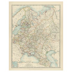
Antique Map of European Russia, 1903, with Colorful Provincial Boundaries
Title: Antique Map of European Russia, 1903, with Colorful Provincial Boundaries
Description:
This antique map, titled "European Russia," was engraved and published in 1903 by W. & ...
Categoría
principios del siglo XX, Mapas
Materiales
Papel
También te puede gustar
Mapa Antiguo Original del Estado Americano de Illinois ( Parte Norte ), 1903
Mapa antiguo de Illinois ( Parte norte )
Publicado por A & C Black. 1903
Color original
Buen estado
Sin enmarcar.
Envío gratuito
Categoría
Antiguo, Principios del 1900, Inglés, Mapas
Materiales
Papel

Mapa Antiguo Original del Estado Americano de Michigan ( Parte Norte ), 1903
Mapa antiguo de Michigan ( parte norte )
Publicado por A & C Black. 1903
Color original
Buen estado
Sin enmarcar.
Envío gratuito
Categoría
Antiguo, Principios del 1900, Inglés, Mapas
Materiales
Papel

Mapa Antiguo Original del Estado Americano de Ohio ( Parte Norte ), 1903
Mapa antiguo de Ohio ( Parte norte )
Publicado por A & C Black. 1903
Color original
Buen estado
Sin enmarcar.
Envío gratuito
Categoría
Antiguo, Principios del 1900, Inglés, Mapas
Materiales
Papel

Mapa Antiguo Original del Estado Americano de California ( Parte Norte ), 1903
Mapa antiguo de California ( Parte norte )
Publicado por A & C Black. 1903
Color original
Buen estado
Sin enmarcar.
Envío gratuito
Categoría
Antiguo, Principios del 1900, Inglés, Mapas
Materiales
Papel

Mapa Antiguo Original del Estado Americano de Missouri ( Parte Norte ), 1903
Mapa antiguo de Missouri ( Parte Norte )
Publicado por A & C Black. 1903
Color original
Buen estado
Sin enmarcar.
Envío gratuito
Categoría
Antiguo, Principios del 1900, Inglés, Mapas
Materiales
Papel

Mapa Antiguo Original del Estado Americano de Nueva York ( Parte Norte ) 1903
Antique map of New York ( Northern Part )
Published By A & C Black. 1903
Original colour
Good condition
Unframed.
Free shipping
Categoría
Antiguo, Principios del 1900, Inglés, Mapas
Materiales
Papel
