Artículos similares a Antique Map of Oceania, 1903, Featuring the Pacific Islands and Australasia


¿Quieres más imágenes o vídeos?
Solicita imágenes o vídeos adicionales al vendedor
1 de 10
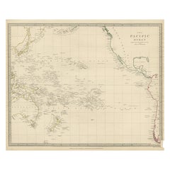
Antique Map of Oceania, 1903, Featuring the Pacific Islands and Australasia
Acerca del artículo
Title: Antique Map of Oceania, 1903, Featuring the Pacific Islands and Australasian Region
Description:
This antique map, titled "Oceania," was engraved and published in 1903 by W. & A.K. Johnston in Edinburgh and London. It provides a comprehensive and visually captivating depiction of the vast and culturally diverse region that includes the islands of the Pacific Ocean, as well as Australia and New Zealand.
Hand-colored in soft pastel shades, the map highlights the political and geographical boundaries of the region at the turn of the 20th century. The major landmasses of Australia, New Zealand, and the Indonesian archipelago are rendered with careful detail, while the islands of Micronesia, Melanesia, and Polynesia—scattered across the Pacific—are marked with precision and clarity.
This map captures not just the geography, but also the maritime networks and colonial ambitions that defined the region at the dawn of the modern era. Trade routes, ocean currents, and key ports are included, emphasizing the interconnectedness of these far-flung lands with the broader world.
For collectors, historians, and those with a passion for the history of exploration and the rich cultures of the Pacific, this map is a window into a time when distant islands and ancient cultures were coming into closer contact with the rest of the globe. The refined engraving and soft colors of the map also make it a striking decorative piece.
Condition report:
This map is in very good antique condition, with minor foxing and gentle edge toning typical for its age. The colors remain vibrant and the paper is stable and well-preserved.
Framing tips:
A classic dark wood frame in walnut or cherry will enhance the pastel colors and maritime elegance of the map. Use a cream or off-white matting to highlight the intricate linework and create a sophisticated, timeless focal point in any home, study, or library.
- Dimensiones:Altura: 36,8 cm (14,49 in)Anchura: 47 cm (18,51 in)Profundidad: 0,2 mm (0,01 in)
- Materiales y técnicas:
- Época:
- Fecha de fabricación:1903
- Estado:This map is in very good antique condition, with minor foxing and gentle edge toning typical for its age. The colors remain vibrant and the paper is stable and well-preserved. Folding line as issued.
- Ubicación del vendedor:Langweer, NL
- Número de referencia:Vendedor: BG-13577-311stDibs: LU3054345262762
Sobre el vendedor
5,0
Vendedor reconocido
Estos prestigiosos vendedores son líderes del sector y representan el escalón más alto en cuanto a calidad y diseño de artículos.
Vendedor Oro
Vendedores premium que mantienen una calificación de +4,3 y tiempos de respuesta de 24 horas
Establecido en 2009
Vendedor de 1stDibs desde 2017
2452 ventas en 1stDibs
Tiempo de respuesta usual: <1 hora
- EnvíoRecuperando presupuesto…Envío desde: Langweer, Países Bajos
- Política de devolución
Partes de esta página se han traducido automáticamente. 1stDibs no puede garantizar la exactitud de las traducciones. El inglés es el idioma predeterminado de este sitio web.
Garantía de autenticidad
En el improbable caso de que haya algún problema con la autenticidad de un artículo, ponte en contacto con nosotros en un plazo de 1 año para recibir un reembolso total. DetallesGarantía de devolución de dinero
Si tu artículo no es como se describe, sufre daños durante el transporte o no llega, ponte en contacto con nosotros en un plazo de 7 días para recibir un reembolso total. DetallesCancelación dentro de las 24 horas
Tienes un período de gracia de 24 horas para reconsiderar tu compra, sin preguntas.Vendedores profesionales aprobados
Nuestros vendedores de primera clase deben cumplir estrictos estándares de servicio para mantener la integridad de nuestros anuncios.Garantía de igualación de precios
Si encuentras que un vendedor publicó el mismo artículo por un precio menor en otro lado, igualaremos ese precio.Entrega global de confianza
Nuestra red de transporte de primera ofrece opciones de envío especializado en todo el mundo, que incluye envío personalizado.Más de este vendedor
Ver todoAntique Map of Italy, 1903, Featuring Islands of Sardinia and Sicily
Title: Antique Map of Italy, 1903, Featuring Islands of Sardinia and Sicily
Description:
This finely detailed antique map, titled "Italy," was engraved and published in 1903 by the ...
Categoría
principios del siglo XX, Mapas
Materiales
Papel
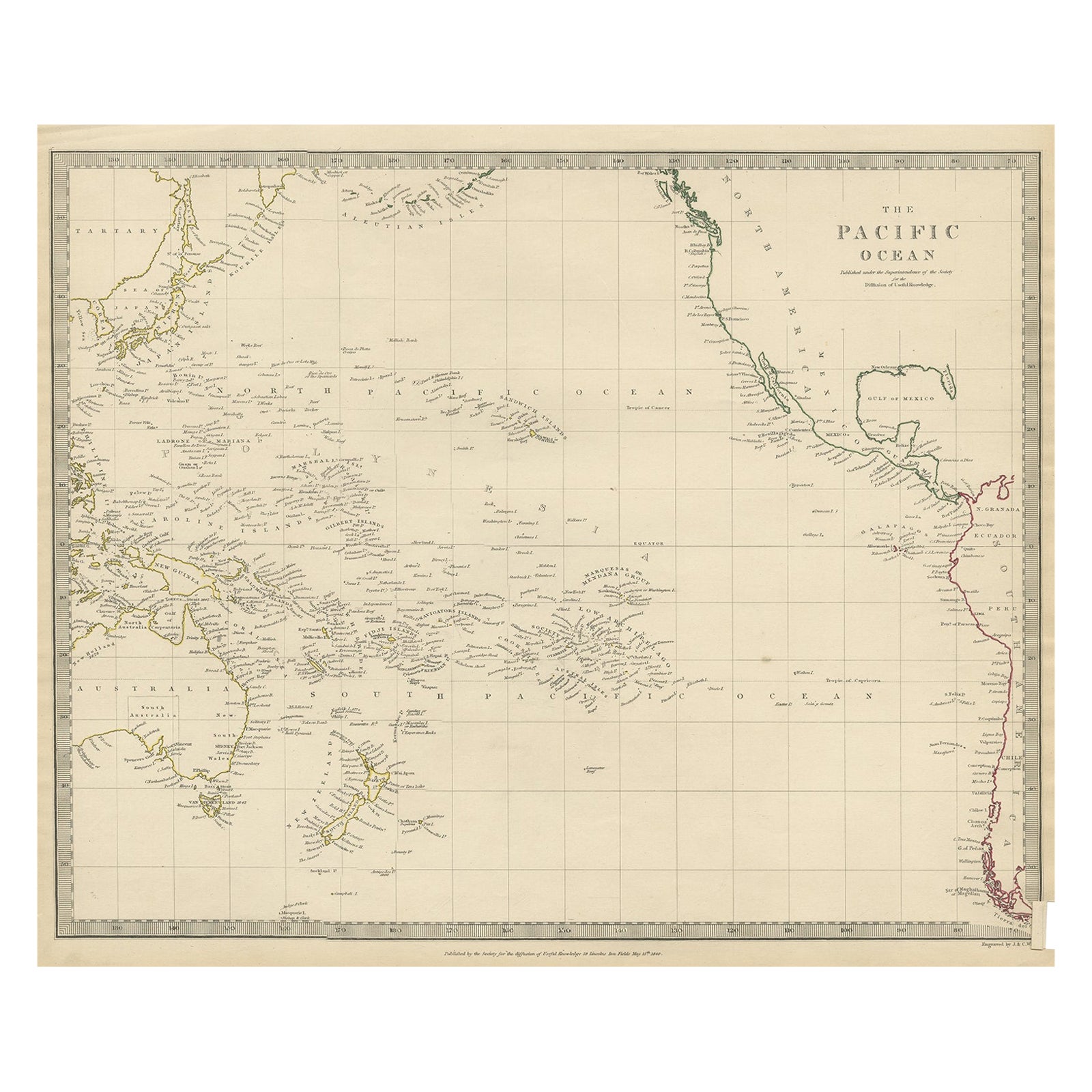
Mapa antiguo de Australasia, Nueva Zelanda, Polinesia y el Océano Pacífico, 1840
Mapa antiguo titulado "El océano Pacífico".
Este mapa representa Australasia, Nueva Zelanda, Polinesia e islas del océano Pacífico, incluidas las islas Sandwich.
Artistas y G...
Categoría
Antiguo, Década de 1840, Mapas
Materiales
Abulón, Papel
205 US$ Precio de venta
Descuento del 20 %
Antique Map of New Zealand, 1903, Featuring the North and South Islands and Alps
Title: Antique Map of New Zealand, 1903, Featuring the North and South Islands and the Southern Alps
Description:
This antique map, titled "New Zealand," was engraved and published ...
Categoría
principios del siglo XX, Mapas
Materiales
Papel

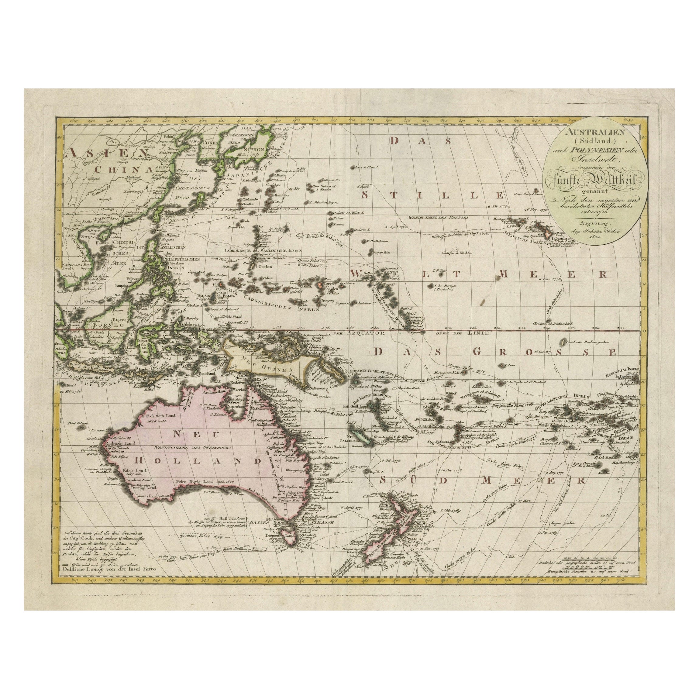
Mapa de Australasia y el Pacífico Sur de 1802 - Rutas de exploración europeas
1802 Johann Walch Mapa de Australasia y el Pacífico Sur - Rutas de exploración europeas
Este mapa de 1802 de Johann Walch ofrece una visión muy detallada de Australasia y el Pacífic...
Categoría
Antiguo, Principios del 1800, Mapas
Materiales
Papel
1680 US$ Precio de venta
Descuento del 20 %
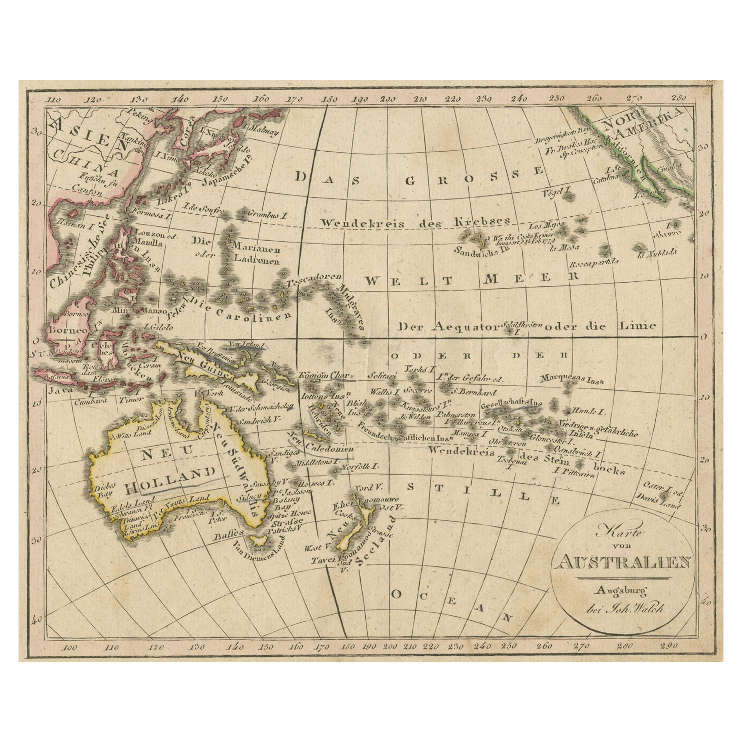
Mapa antiguo de Oceanía y del Océano Pacífico, Australia y Nueva Zelanda, 1826
Mapa antiguo de Australia titulado "Karte von Australien". Antiguo mapa de Australia y Nueva Zelanda. Publicado en el "Neuester Schul-Atlas" de Walch.
Artistas y grabadores: Joha...
Categoría
Antiguo, siglo XIX, Mapas
Materiales
Papel
149 US$ Precio de venta
Descuento del 20 %
Mapa antiguo de las Islas del Océano Pacífico por Wyld, '1845
Mapa antiguo titulado "Islas del Océano Pacífico". Mapa antiguo original de las islas del océano Pacífico. Este mapa procede de "An Atlas of the World, Comprehending Separate Maps of...
Categoría
Antiguo, Mediados del siglo XIX, Mapas
Materiales
Papel

186 US$ Precio de venta
Descuento del 20 %
También te puede gustar
Mapa Antiguo Original del Estado Americano de Connecticut y Rhode Island, 1903
Antique map of Connecticut and Rhode Island
Published By A & C Black. 1903
Original colour
Good condition
Unframed.
Free shipping
Categoría
Antiguo, Principios del 1900, Inglés, Mapas
Materiales
Papel

Gran mapa original de época de las islas del Pacífico, incluido Hawaii
Gran mapa de las Islas del Pacífico
Sin enmarcar
Color original
Por John Bartholomew y Co. Instituto Geográfico de Edimburgo
Publicado, hacia 1920
Envío gratuito.
Categoría
Vintage, Década de 1920, Británico, Mapas
Materiales
Papel

Mapa original antiguo del estado norteamericano de Minnesota, 1903
Mapa antiguo de Minnesota
Publicado por A & C Black. 1903
Color original
Buen estado
Sin enmarcar.
Envío gratuito
Categoría
Antiguo, Principios del 1900, Inglés, Mapas
Materiales
Papel

Mapa original antiguo del estado norteamericano de Alabama, 1903
Antique map of Alabama
Published By A & C Black. 1903
Original colour
Good condition
Unframed.
Free shipping
Categoría
Antiguo, Principios del 1900, Inglés, Mapas
Materiales
Papel

Mapa original antiguo del estado norteamericano de Alaska, 1903
Mapa antiguo de Alaska
Publicado por A & C Black. 1903
Color original
Buen estado
Sin enmarcar.
Envío gratuito
Categoría
Antiguo, Principios del 1900, Inglés, Mapas
Materiales
Papel

Mapa original antiguo del estado norteamericano de Nebraska, 1903
Mapa antiguo de Nebraska
Publicado por A & C Black. 1903
Color original
Buen estado
Sin enmarcar.
Envío gratuito
Categoría
Antiguo, Principios del 1900, Inglés, Mapas
Materiales
Papel
