Artículos similares a Antique Map of Piedmont, Savoy and Liguria by Justus Danckerts, Amsterdam c.1690


¿Quieres más imágenes o vídeos?
Solicita imágenes o vídeos adicionales al vendedor
1 de 11
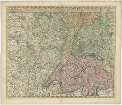
Antique Map of Piedmont, Savoy and Liguria by Justus Danckerts, Amsterdam c.1690
850 €IVA incluido
Acerca del artículo
Map of Piedmont, Savoy and Liguria by Justus Danckerts, Amsterdam c.1690
This richly detailed and decorative map, titled *Tabula Generalis Ducatus Sabaudiae Principatus Pedemontii Comitatum Nicaeensis et Ducatus Montisferrati*, was published around 1690 by the Amsterdam cartographer Justus Danckerts (Iustinus Danckerus). He was one of the leading mapmakers in the Netherlands during the late 17th century, part of a family renowned for producing finely engraved and colored maps.
The map covers a large swath of Northern Italy and parts of southeastern France, focusing on the Duchy of Savoy, the Principality of Piedmont, the County of Nice, and the Ligurian coast, including Genoa. It reflects the strategic and political importance of these territories, especially during a time of shifting alliances and ongoing wars among European powers.
Danckerts’s map stands out for its clarity and precision, showing a dense network of cities, rivers, mountain ranges, and territorial boundaries. The Alps are rendered in expressive hachuring, and each region is outlined in hand-applied color. Prominent cities such as Turin, Nice, and Genoa are labeled, as well as key geographic features like Lake Geneva, the Po River, and the Mediterranean coast.
A beautifully ornate cartouche at the lower right features allegorical figures, coats of arms, and a dedication, highlighting the grandeur and authority of the map. The artistry and execution are typical of Dutch Golden Age cartography—both practical and decorative.
This map would have served as an important reference for military strategists, diplomats, and merchants operating in this politically significant region at the crossroads of France and Italy.
Condition summary:
Very good condition with original hand-color, central fold as issued, mild age toning. Strong impression but tight margins and some borders reinforced. A fine example of late 17th-century Dutch cartography.
Framing tips:
Best displayed in a dark wood or gold-leaf frame with a cream or soft beige mat to bring out the color contrast. Use UV-protective glass to preserve the hand-coloring and paper integrity over time.
- Dimensiones:Altura: 52 cm (20,48 in)Anchura: 60,6 cm (23,86 in)Profundidad: 0,2 mm (0,01 in)
- Materiales y técnicas:Papel,Grabado
- Época:finales del siglo XVII
- Fecha de fabricación:circa 1690
- Estado:Refinado. Very good condition with original hand-color, central fold as issued, mild age toning. Strong impression but tight margins and some borders reinforced. A fine example of late 17th-century Dutch cartography.
- Ubicación del vendedor:Langweer, NL
- Número de referencia:Vendedor: BG-13732-51stDibs: LU3054345364122
Sobre el vendedor
5,0
Vendedor reconocido
Estos prestigiosos vendedores son líderes del sector y representan el escalón más alto en cuanto a calidad y diseño de artículos.
Vendedor Platino
Vendedores premium con una calificación de +4,7 y tiempos de respuesta de 24 horas
Establecido en 2009
Vendedor de 1stDibs desde 2017
2622 ventas en 1stDibs
Tiempo de respuesta usual: <1 hora
- EnvíoRecuperando presupuesto…Envío desde: Langweer, Países Bajos
- Política de devolución
Partes de esta página se han traducido automáticamente. 1stDibs no puede garantizar la exactitud de las traducciones. El inglés es el idioma predeterminado de este sitio web.
Garantía de autenticidad
En el improbable caso de que haya algún problema con la autenticidad de un artículo, ponte en contacto con nosotros en un plazo de 1 año para recibir un reembolso total. DetallesGarantía de devolución de dinero
Si tu artículo no es como se describe, sufre daños durante el transporte o no llega, ponte en contacto con nosotros en un plazo de 7 días para recibir un reembolso total. DetallesCancelación dentro de las 24 horas
Tienes un período de gracia de 24 horas para reconsiderar tu compra, sin preguntas.Vendedores profesionales aprobados
Nuestros vendedores de primera clase deben cumplir estrictos estándares de servicio para mantener la integridad de nuestros anuncios.Garantía de igualación de precios
Si encuentras que un vendedor publicó el mismo artículo por un precio menor en otro lado, igualaremos ese precio.Entrega global de confianza
Nuestra red de transporte de primera ofrece opciones de envío especializado en todo el mundo, que incluye envío personalizado.Más de este vendedor
Ver todoMapa antiguo del norte de Italia por F. de Wit, 1690
Mapa muy decorativo centrado en Génova y que incluye las ciudades de Milán, Turín, Parma, Cremona, etc. Cartela decorativa en la parte superior derecha con cinco putti que sostienen ...
Categoría
Antiguo, finales del siglo XVII, Mapas
Materiales
Papel

440 € Precio de venta
Descuento del 20 %
Mapa antiguo de Suiza por N. Visscher, hacia 1690
Mapa antiguo titulado "Tabula Geogaphica qua Pars Meridionalis sive Superior Rheni, Mosae, et Mosellae (..)". Publicado por N. Visscher, Amsterdam, hacia 1690. Coloración contemporánea.
Categoría
Antiguo, finales del siglo XVII, Mapas
Materiales
Papel
532 € Precio de venta
Descuento del 20 %
Mapa antiguo de Austria por F. de Wit, 1690
Mapa antiguo titulado "Circuli Austriaci pars Septentrionalis in qua Archiducatus". Mapa decorativo y detallado de Austria por F. de Wit.
Categoría
Antiguo, finales del siglo XVII, Holandés, Mapas
Materiales
Papel

Raro mapa coloreado a mano de la región del Lyonnais en Francia por Frederik De Wit c. 1688
Título: Raro mapa coloreado a mano de la región de Lyonnais por Frederik De Wit c. 1688
Descripción: Este mapa bellamente detallado, "Gouvernement General du Lyonnois", muestra la r...
Categoría
Antiguo, Década de 1680, Mapas
Materiales
Papel

Decorativo Mapa Antiguo Original del Sur de Alemania, c.1730
"Mapa antiguo titulado "La parte suroeste de Alemania. Containing ye Dominions of the Archbishops and Electors of Mentz Y Treves, and of ye Elec. Palatino del Rin; con Franconia, Sua...
Categoría
Antiguo, siglo XVIII, Mapas
Materiales
Papel

Mapa antiguo del norte de Italia por Homann Heirs, c.1730
Mapa antiguo titulado 'Domini Veneti cum vicinis Parmae Mutinae, Matuae et Mirandol (..).' Mapa detallado del norte de Italia por J. B. Homann. Este mapa muestra Venecia y sus estado...
Categoría
Antiguo, siglo XVIII, Mapas
Materiales
Papel

416 € Precio de venta
Descuento del 20 %
También te puede gustar
1640 Mapa de Willem Blaeu titulado "Contado di molise et principato vltra, " Ric.a003
Por Willem Blaeu
Mapa de Willem Blaeu de 1640 titulado
"Contado di molise et principato vltra,"
Coloreado
Ric. a003
Medidas: 38 x 49,6 cm y amplios márgenes
DBLAEU.
Condado de Molise y P...
Categoría
Antiguo, siglo XVII, Holandés, Mapas
Materiales
Papel

Mapa original antiguo de Suiza, grabado por Barlow, fechado en 1807
Gran mapa de Suiza
Grabado en plancha de cobre de Barlow
Publicado por Brightly & Kinnersly, Bungay, Suffolk.
Fechado en 1807
Sin enmarcar.
Categoría
Antiguo, Principios del 1800, Inglés, Mapas
Materiales
Papel

Mapa del siglo XVIII del sur de los Balcanes, de Giovanni Maria Cassini
Por Giovanni Maria Cassini
Mapa del siglo XVIII del grabador italiano Giovanni Maria Cassini (Italia 1745-1824).
Mapa de los Balcanes Meridionales: Roma. Estampa coloreada a mano y grabada en cobre realizada ...
Categoría
Antiguo, siglo XVIII, Italiano, Mapas
Materiales
Papel

690 € Precio de venta
Descuento del 36 %
Mapa antiguo - Macedonia - Grabado de Johannes Janssonius - Década de 1650
Por Johannes Janssonius
Macedonia es un mapa antiguo realizado en 1650 por Johannes Janssonius (1588-1664).
El Mapa es un grabado coloreado a mano, con acuarela coetánea.
Buen estado de conservación, con ...
Categoría
Década de 1650, Moderno, Impresiones figurativas
Materiales
Grabado químico

Alemania Occidental: Mapa original del siglo XVII coloreado a mano por Johannes Janssonius
Por Johannes Janssonius
Mapa original grabado en cobre coloreado a mano, titulado en latín "Archiepiscopatus Maghdeburgensis et Anhaltinus Ducatus cum terris adjacentibus", publicado en Amsterdam en 1640 en...
Categoría
mediados del siglo XVII, Antiguos maestros, Más impresiones
Materiales
Grabado

Mapa antiguo - Gallia - Grabado de Johannes Janssonius - Década de 1650
Por Johannes Janssonius
Mapa antiguo - Gallia es un mapa antiguo realizado en 1650 por Johannes Janssonius (1588-1664).
El Mapa es un grabado coloreado a mano, con acuarela coetánea.
Buen estado de conser...
Categoría
Década de 1650, Moderno, Impresiones figurativas
Materiales
Grabado químico
