Artículos similares a Antique Map of South Australia, New South Wales, Victoria and Queensland, 1903


¿Quieres más imágenes o vídeos?
Solicita imágenes o vídeos adicionales al vendedor
1 de 10
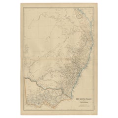
Antique Map of South Australia, New South Wales, Victoria and Queensland, 1903
Acerca del artículo
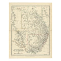
Title: Antique Map of South Australia, New South Wales, Victoria, and Queensland, 1903
Description:
This antique map, titled "South Australia, New South Wales, Victoria, and Queensland," was engraved and published in 1903 by W. & A.K. Johnston in Edinburgh and London. It provides a beautifully detailed and historically rich depiction of southeastern Australia during a formative period in its development as part of the British Empire and, after 1901, the Commonwealth of Australia.
The map is delicately hand-colored in soft pastel shades to differentiate the colonial borders of the time. It meticulously traces out major cities, towns, rivers, mountain ranges, and transportation routes, offering a snapshot of the political and economic landscape of these bustling colonies at the dawn of the 20th century.
An inset of the Torres Strait and northern Queensland provides additional detail on these important coastal regions. The map’s precision and clarity speak to the exceptional skill of Johnston’s cartographers, capturing the interplay between natural features and the growing infrastructure of a rapidly developing continent.
For collectors, historians, and enthusiasts of Australian history, this map is more than just a decorative piece—it is a tangible record of the region’s colonial heritage and the roots of modern Australia. It highlights both the grandeur of Australia’s natural environment and the ambition of the settlers and Indigenous communities who shaped its destiny.
Condition report:
This map is in very good antique condition, with only minor foxing and gentle toning along the edges, consistent with its age. The colors remain vibrant and the paper is stable and well-preserved.
Framing tips:
A classic wooden frame in walnut or cherry will complement the warm pastel colors and fine detailing of this map. Use a cream or off-white matting to highlight the intricate linework and create a refined, timeless focal point for any home, library, or study.
- Dimensiones:Altura: 47 cm (18,51 in)Anchura: 36,8 cm (14,49 in)Profundidad: 0,2 mm (0,01 in)
- Materiales y técnicas:
- Época:
- Fecha de fabricación:1903
- Estado:This map is in very good antique condition, with minor foxing and gentle edge toning typical for its age. The colors remain vibrant and the paper is stable and well-preserved. Folding line as issued.
- Ubicación del vendedor:Langweer, NL
- Número de referencia:Vendedor: BG-13577-331stDibs: LU3054345263362
Sobre el vendedor
5,0
Vendedor reconocido
Estos prestigiosos vendedores son líderes del sector y representan el escalón más alto en cuanto a calidad y diseño de artículos.
Vendedor Oro
Vendedores premium que mantienen una calificación de +4,3 y tiempos de respuesta de 24 horas
Establecido en 2009
Vendedor de 1stDibs desde 2017
2464 ventas en 1stDibs
Tiempo de respuesta usual: 1 hora
- EnvíoRecuperando presupuesto…Envío desde: Langweer, Países Bajos
- Política de devolución
Partes de esta página se han traducido automáticamente. 1stDibs no puede garantizar la exactitud de las traducciones. El inglés es el idioma predeterminado de este sitio web.
Garantía de autenticidad
En el improbable caso de que haya algún problema con la autenticidad de un artículo, ponte en contacto con nosotros en un plazo de 1 año para recibir un reembolso total. DetallesGarantía de devolución de dinero
Si tu artículo no es como se describe, sufre daños durante el transporte o no llega, ponte en contacto con nosotros en un plazo de 7 días para recibir un reembolso total. DetallesCancelación dentro de las 24 horas
Tienes un período de gracia de 24 horas para reconsiderar tu compra, sin preguntas.Vendedores profesionales aprobados
Nuestros vendedores de primera clase deben cumplir estrictos estándares de servicio para mantener la integridad de nuestros anuncios.Garantía de igualación de precios
Si encuentras que un vendedor publicó el mismo artículo por un precio menor en otro lado, igualaremos ese precio.Entrega global de confianza
Nuestra red de transporte de primera ofrece opciones de envío especializado en todo el mundo, que incluye envío personalizado.Más de este vendedor
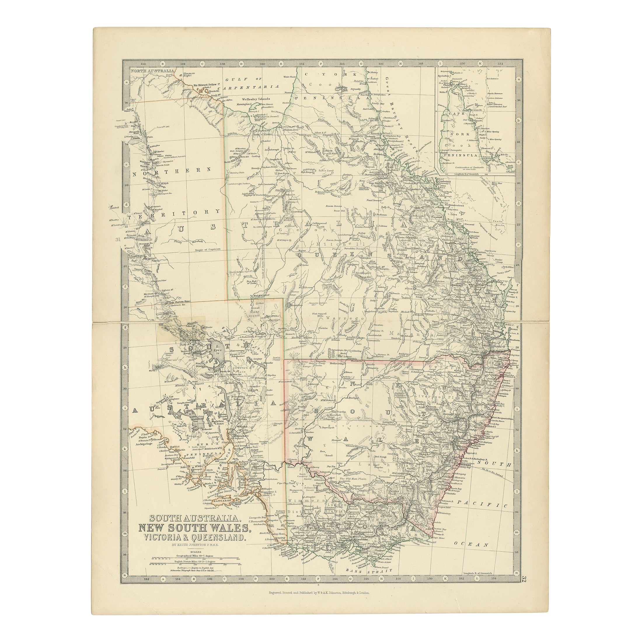
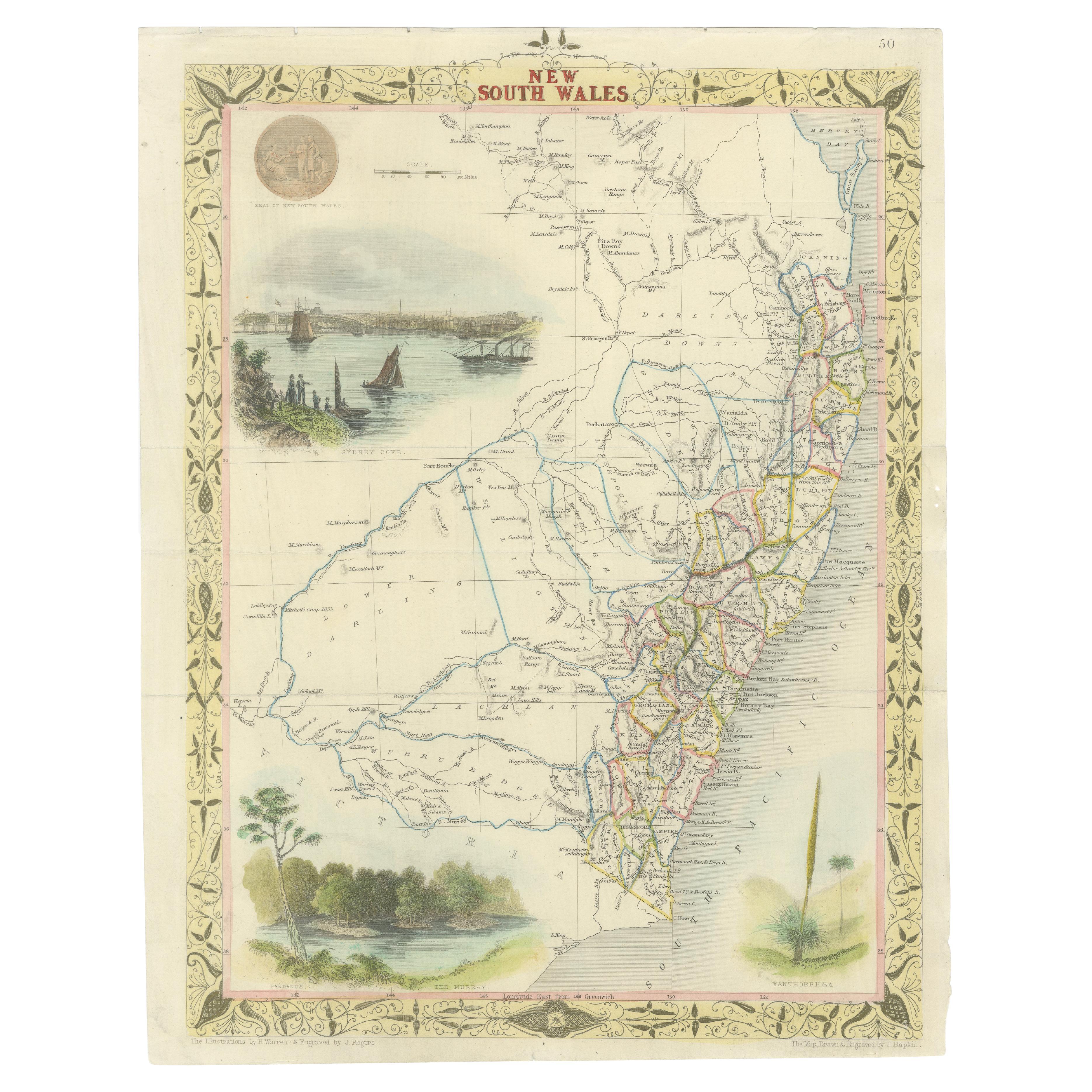
Ver todoMapa antiguo de Australia Meridional, Victoria, Queensland y Nueva Gales del Sur, c.1860
Mapa antiguo de Australia titulado "Australia Meridional, Nueva Gales del Sur, Victoria y Queensland". Antiguo mapa que representa Australia Meridional, incluyendo Nueva Gales del Su...
Categoría
Antiguo, siglo XIX, Mapas
Materiales
Papel
316 US$ Precio de venta
Descuento del 20 %
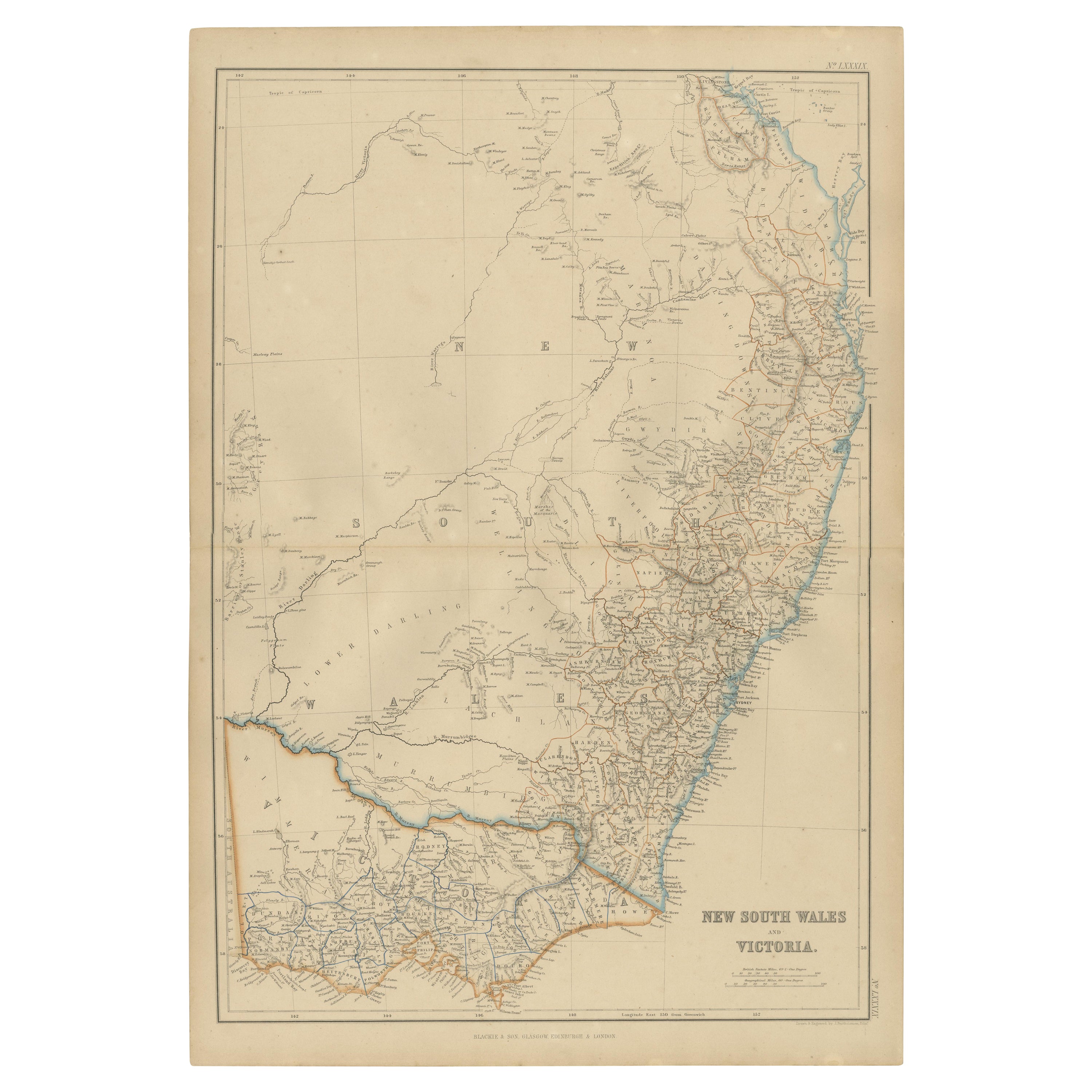
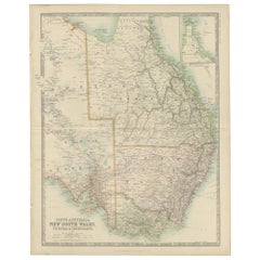
Antiguo mapa detallado de Nueva Gales del Sur, Queensland y Victoria, Australia, 1865
Mapa antiguo de Australia titulado "Australia Meridional, Nueva Gales del Sur, Victoria y Queensland". Antiguo mapa que representa Australia Meridional, incluyendo Nueva Gales del Su...
Categoría
Antiguo, siglo XIX, Mapas
Materiales
Papel
325 US$ Precio de venta
Descuento del 20 %
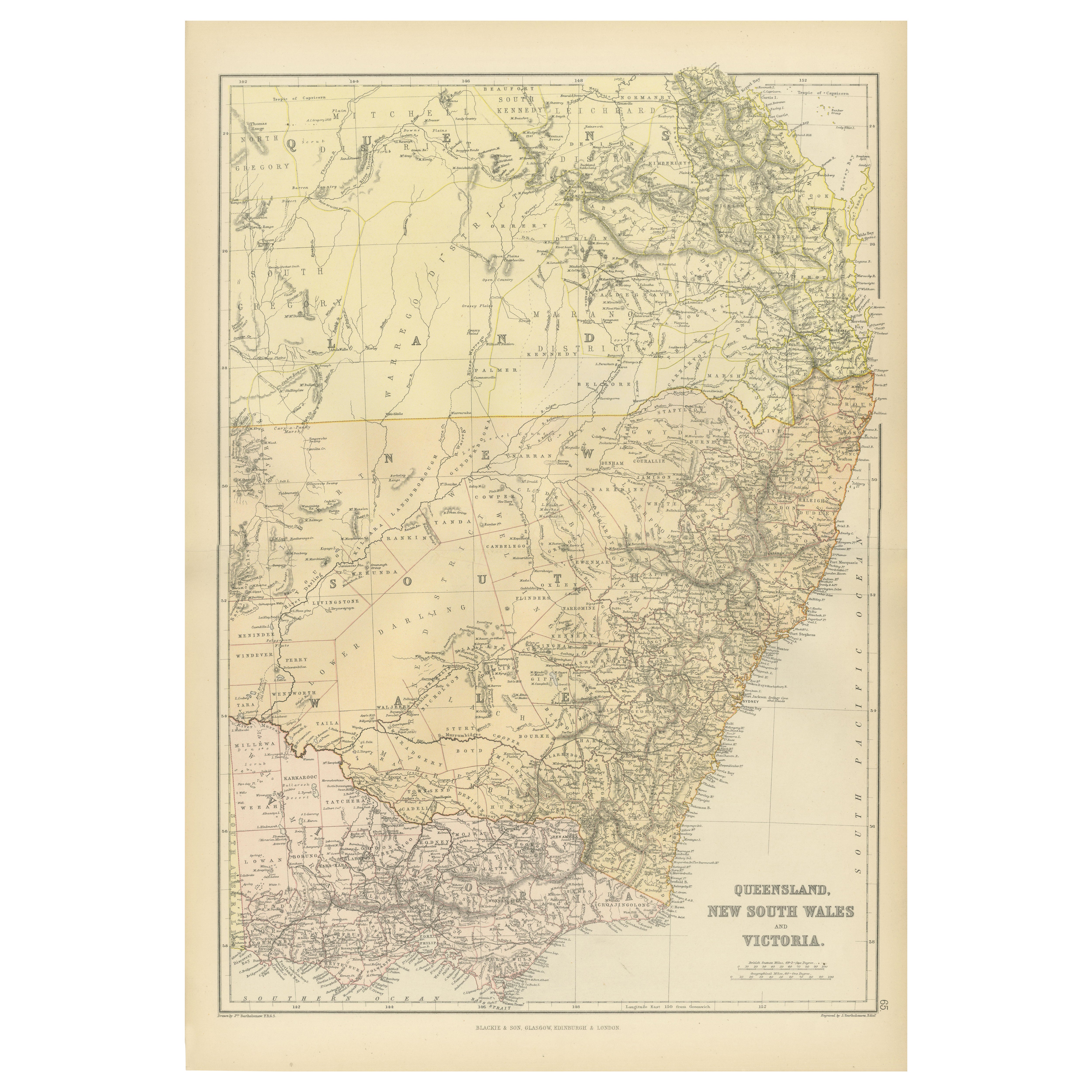
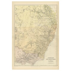
Mapa de Queensland, Nueva Gales del Sur y Victoria de 1882 con características detalladas
Este mapa de 1882 de Queensland, Nueva Gales del Sur y Victoria, publicado por Blackie and Son como parte del "Atlas y Geografía Completos del Mundo", ofrece una descripción detallad...
Categoría
Antiguo, Década de 1880, Mapas
Materiales
Papel
Mapa antiguo de Nueva Gales del Sur y Victoria por W. G. Blackie, 1859
Mapa antiguo titulado "Nueva Gales del Sur y Victoria". Mapa antiguo original de Nueva Gales del Sur y Victoria. Este mapa procede del "Atlas Imperial de Geografía Moderna". Publicad...
Categoría
Antiguo, Mediados del siglo XIX, Mapas
Materiales
Papel
232 US$ Precio de venta
Descuento del 20 %
Mapa antiguo de Nueva Gales del Sur 'Australia' por Wyld '1845'
Mapa antiguo titulado "Asentamientos británicos en Nueva Gales del Sur". Mapa antiguo original de Nueva Gales del Sur, Australia. Este mapa procede de "An Atlas of the World, Compreh...
Categoría
Antiguo, Mediados del siglo XIX, Mapas
Materiales
Papel

232 US$ Precio de venta
Descuento del 20 %
Mapa antiguo de Nueva Gales del Sur en Australia, ca. 1850
Mapa antiguo de Victoria, o Port Phillip (12,7 x 10,0") en Australia. Magnífico mapa de Victoria centrado aproximadamente en Melbourne. Viñetas de aborígenes, un canguro y una gran v...
Categoría
Antiguo, Mediados del siglo XIX, Europeo, Mapas
Materiales
Papel

690 US$ Precio de venta
Descuento del 40 %
Envío gratuito
También te puede gustar
Mapa Antiguo Original del Estado Americano de Carolina del Sur, 1903
Antique map of South Carolina
Published By A & C Black. 1903
Original colour
Good condition
Unframed.
Free shipping
Categoría
Antiguo, Principios del 1900, Inglés, Mapas
Materiales
Papel

Mapa original antiguo del estado norteamericano de Dakota del Sur, 1903
Mapa antiguo de Dakota del Sur
Publicado por A & C Black. 1903
Color original
Buen estado
Sin enmarcar.
Envío gratuito
Categoría
Antiguo, Principios del 1900, Inglés, Mapas
Materiales
Papel

Mapa original antiguo del estado norteamericano de Nueva Jersey, 1903
Antique map of New Jersey
Published By A & C Black. 1903
Original colour
Good condition
Unframed.
Free shipping
Categoría
Antiguo, Principios del 1900, Inglés, Mapas
Materiales
Papel
Mapa Antiguo Original del Estado Americano de Arizona y Nuevo México, 1903
Mapa antiguo de Arizona y Nuevo México
Publicado por A & C Black. 1903
Color original
Buen estado
Sin enmarcar.
Envío gratuito
Categoría
Antiguo, Principios del 1900, Inglés, Mapas
Materiales
Papel

Mapa original antiguo de los estados americanos de Vermont y Nuevo Hampshire, 1903
Antique map of Vermont and New Hampshire
Published By A & C Black. 1903
Original colour
Good condition
Unframed.
Free shipping
Categoría
Antiguo, Principios del 1900, Inglés, Mapas
Materiales
Papel
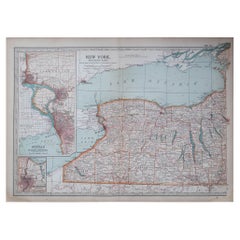
Mapa Antiguo Original del Estado Americano de Nueva York ( Parte Occidental ) 1903
Antique map of New York ( Western Part )
Published By A & C Black. 1903
Original colour
Good condition
Unframed.
Free shipping
Categoría
Antiguo, Principios del 1900, Inglés, Mapas
Materiales
Papel