Artículos similares a Antique Map of Southern England & Wales, 1903, with Coastal Details and Railways


¿Quieres más imágenes o vídeos?
Solicita imágenes o vídeos adicionales al vendedor
1 de 10
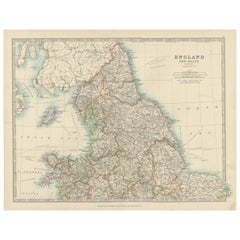
Antique Map of Southern England & Wales, 1903, with Coastal Details and Railways
Acerca del artículo
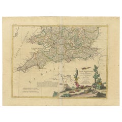
Title: Antique Map of Southern England and Wales, 1903, with Coastal Details and Railways
Description:
This detailed antique map, titled "England and Wales (Southern Sheet I)," was engraved and published in 1903 by W. & A.K. Johnston in Edinburgh and London. It offers a fascinating and intricate depiction of the southern part of England and Wales, showcasing counties, cities, towns, and natural features with exceptional clarity and artistry.
The map features the vibrant regions of Southern England, including Devon, Cornwall, Somerset, and the bustling metropolis of London. It also extends to Wales, highlighting the rugged coastline along the Bristol Channel and the scenic beauty of the English Channel. The fine engraving and subtle pastel coloring—using shades of green, pink, and yellow—create a refined and harmonious composition that brings this historical period to life.
One of the map’s highlights is its inclusion of the Scilly Islands in a dedicated inset, emphasizing their geographical and navigational importance. Extensive railway lines are meticulously marked, a testament to the region’s burgeoning industrial development and the vital role of rail transport in connecting towns and fostering economic growth during this transformative period.
For collectors and history enthusiasts, this map is not only a decorative statement but also a window into the geography and infrastructure of the United Kingdom at the beginning of the 20th century. It reflects an era of rapid modernization and urban expansion while preserving the rich character of the British landscape.
Condition report:
This map is in very good antique condition, with slight toning around the edges and minor foxing consistent with its age. The colors remain vibrant and the paper stable and intact.
Framing tips:
Select a traditional wooden frame in walnut or oak to complement the map’s historic charm. Use a cream or light tan matting to highlight the pastel coloring and intricate engraving, ensuring the map stands out as a sophisticated and elegant addition to any room.
- Dimensiones:Altura: 36,8 cm (14,49 in)Anchura: 48 cm (18,9 in)Profundidad: 0,2 mm (0,01 in)
- Materiales y técnicas:
- Época:
- Fecha de fabricación:1903
- Estado:This map is in very good antique condition, with slight toning around the edges and minor foxing consistent with its age. The colors remain vibrant and the paper stable and intact. Folding line as issued.
- Ubicación del vendedor:Langweer, NL
- Número de referencia:Vendedor: BG-13577-51stDibs: LU3054345241052
Sobre el vendedor
5,0
Vendedor reconocido
Estos prestigiosos vendedores son líderes del sector y representan el escalón más alto en cuanto a calidad y diseño de artículos.
Vendedor Oro
Vendedores premium que mantienen una calificación de +4,3 y tiempos de respuesta de 24 horas
Establecido en 2009
Vendedor de 1stDibs desde 2017
2452 ventas en 1stDibs
Tiempo de respuesta usual: <1 hora
- EnvíoRecuperando presupuesto…Envío desde: Langweer, Países Bajos
- Política de devolución
Partes de esta página se han traducido automáticamente. 1stDibs no puede garantizar la exactitud de las traducciones. El inglés es el idioma predeterminado de este sitio web.
Garantía de autenticidad
En el improbable caso de que haya algún problema con la autenticidad de un artículo, ponte en contacto con nosotros en un plazo de 1 año para recibir un reembolso total. DetallesGarantía de devolución de dinero
Si tu artículo no es como se describe, sufre daños durante el transporte o no llega, ponte en contacto con nosotros en un plazo de 7 días para recibir un reembolso total. DetallesCancelación dentro de las 24 horas
Tienes un período de gracia de 24 horas para reconsiderar tu compra, sin preguntas.Vendedores profesionales aprobados
Nuestros vendedores de primera clase deben cumplir estrictos estándares de servicio para mantener la integridad de nuestros anuncios.Garantía de igualación de precios
Si encuentras que un vendedor publicó el mismo artículo por un precio menor en otro lado, igualaremos ese precio.Entrega global de confianza
Nuestra red de transporte de primera ofrece opciones de envío especializado en todo el mundo, que incluye envío personalizado.Más de este vendedor
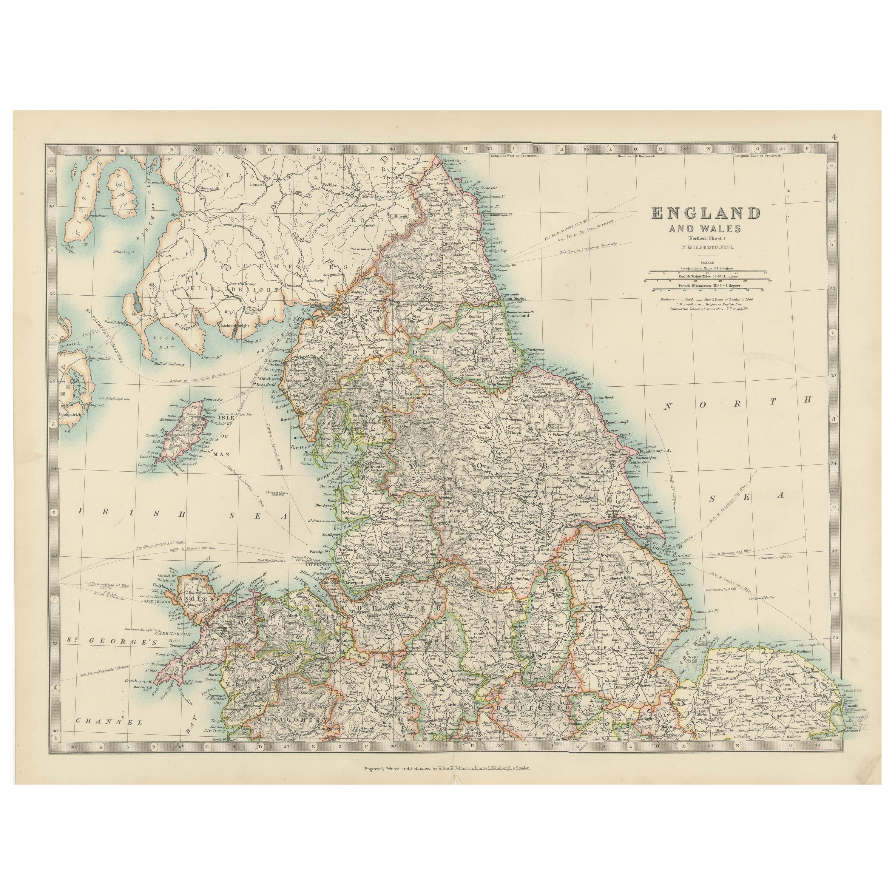
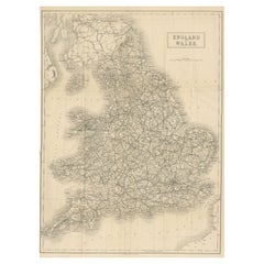
Ver todoAntique Map of England and Wales, 1903, with Detailed Counties and Railways
Title: Antique Map of England and Wales, 1903, with Detailed Counties and Railways
Description:
This beautifully detailed antique map, titled "England and Wales," was engraved and p...
Categoría
principios del siglo XX, Mapas
Materiales
Papel
Antique Map of Southern Scotland, 1903, with Coastal and Inland Details
Title: Antique Map of Southern Scotland, 1903, with Coastal and Inland Details
Description:
This exquisite antique map, titled "Scotland (Southern Sheet I)," was engraved and publis...
Categoría
principios del siglo XX, Mapas
Materiales
Papel

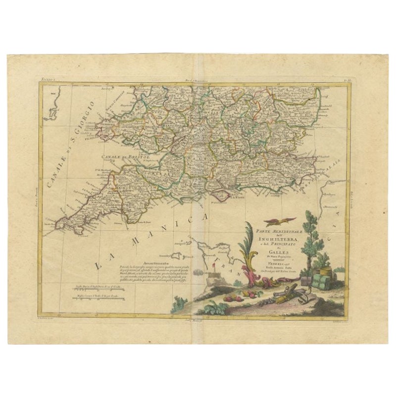
Mapa antiguo del sur de Inglaterra y Gales por Zatta, 1784
"Mapa antiguo titulado "Parte Meridionale dell' Inghilterra e del Pricipato di Galles". Mapa grabado de la parte meridional de Inglaterra y Gales, con cartela en el título. Muestra d...
Categoría
Antiguo, siglo XVIII, Mapas
Materiales
Papel
198 US$ Precio de venta
Descuento del 20 %
Antique Map of Ireland, 1903, with Intricate County Boundaries & Coastal Details
Title: Antique Map of Ireland, 1903, with Intricate County Boundaries and Coastal Detail
Description:
This antique map of Ireland, engraved and published in 1903 by the esteemed W. ...
Categoría
principios del siglo XX, Mapas
Materiales
Papel

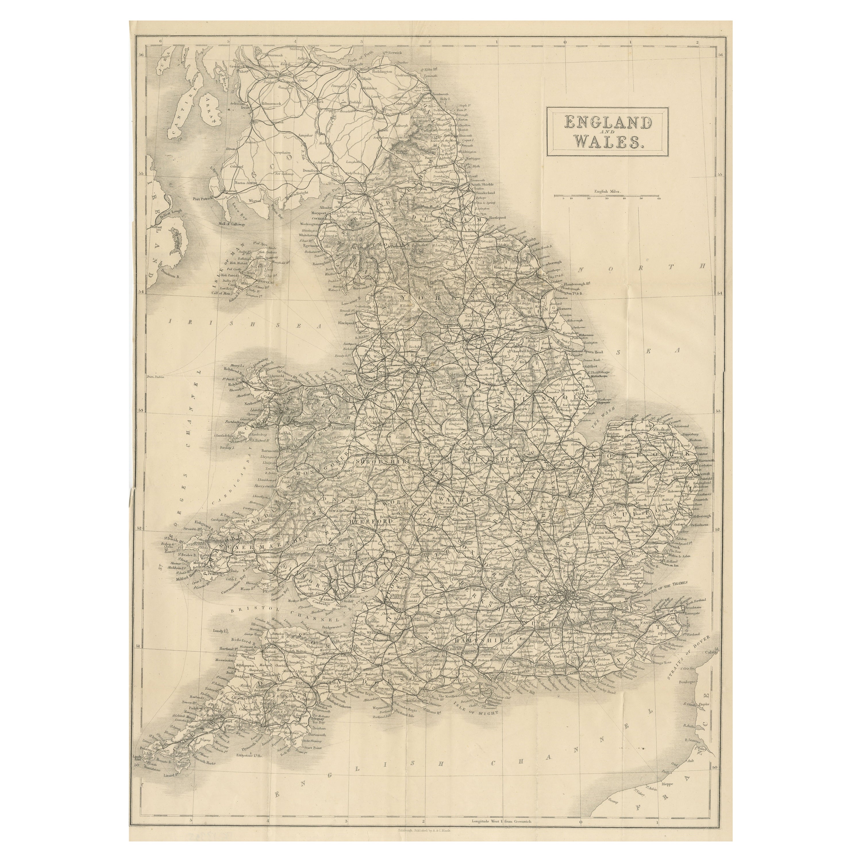
Antiguo mapa plegable de Inglaterra y Gales
Mapa antiguo titulado "Inglaterra y Gales". Mapa original plegable de Inglaterra y Gales. Publicado por A. & C. Black, hacia 1890.
Categoría
Antiguo, Fines del siglo XIX, Mapas
Materiales
Papel
392 US$ Precio de venta
Descuento del 20 %
Gran Mapa Antiguo de Inglaterra y Gales
Mapa antiguo titulado "Un mapa preciso de Inglaterra y Gales". Antiguo mapa original de Inglaterra y Gales. Grabado por John Cary. Procede del "Nuevo Atlas Británico" de John Stockda...
Categoría
Antiguo, principios del siglo XIX, Mapas
Materiales
Papel

308 US$ Precio de venta
Descuento del 20 %
También te puede gustar
Mapa Antiguo Original del Estado Americano de Michigan ( Parte Sur ), 1903
Mapa antiguo de Michigan ( Parte sur )
Publicado por A & C Black. 1903
Color original
Buen estado
Sin enmarcar.
Envío gratuito
Categoría
Antiguo, Principios del 1900, Inglés, Mapas
Materiales
Papel

Mapa Antiguo Original del Estado Americano de Ohio ( Parte Sur ), 1903
Mapa antiguo de Ohio ( Parte sur )
Publicado por A & C Black. 1903
Color original
Buen estado
Sin enmarcar.
Envío gratuito
Categoría
Antiguo, Principios del 1900, Inglés, Mapas
Materiales
Papel

Mapa Antiguo Original del Estado Americano de California ( Parte Sur ), 1903
Mapa antiguo de California ( Parte sur )
Publicado por A & C Black. 1903
Color original
Buen estado
Sin enmarcar.
Envío gratuito
Categoría
Antiguo, Principios del 1900, Inglés, Mapas
Materiales
Papel

Mapa Antiguo Original del Estado Americano de Illinois ( Parte Sur ), 1903
Mapa antiguo de Illinois ( Parte sur )
Publicado por A & C Black. 1903
Color original
Buen estado
Sin enmarcar.
Envío gratuito
Categoría
Antiguo, Principios del 1900, Inglés, Mapas
Materiales
Papel

Mapa Antiguo Original del Estado Americano de Missouri ( Parte Sur ), 1903
Mapa antiguo de Missouri ( Parte Sur )
Publicado por A & C Black. 1903
Color original
Buen estado
Sin enmarcar.
Envío gratuito
Categoría
Antiguo, Principios del 1900, Inglés, Mapas
Materiales
Papel

Mapa Antiguo Original del Estado Americano de Nueva York ( Parte Sur ) 1903
Antique map of New York ( Southern Part )
Published By A & C Black. 1903
Original colour
Good condition
Unframed.
Free shipping
Categoría
Antiguo, Principios del 1900, Inglés, Mapas
Materiales
Papel
