Artículos similares a Antique Map of Southern India and South Eastern Provinces, 1903

¿Quieres más imágenes o vídeos?
Solicita imágenes o vídeos adicionales al vendedor
1 de 10
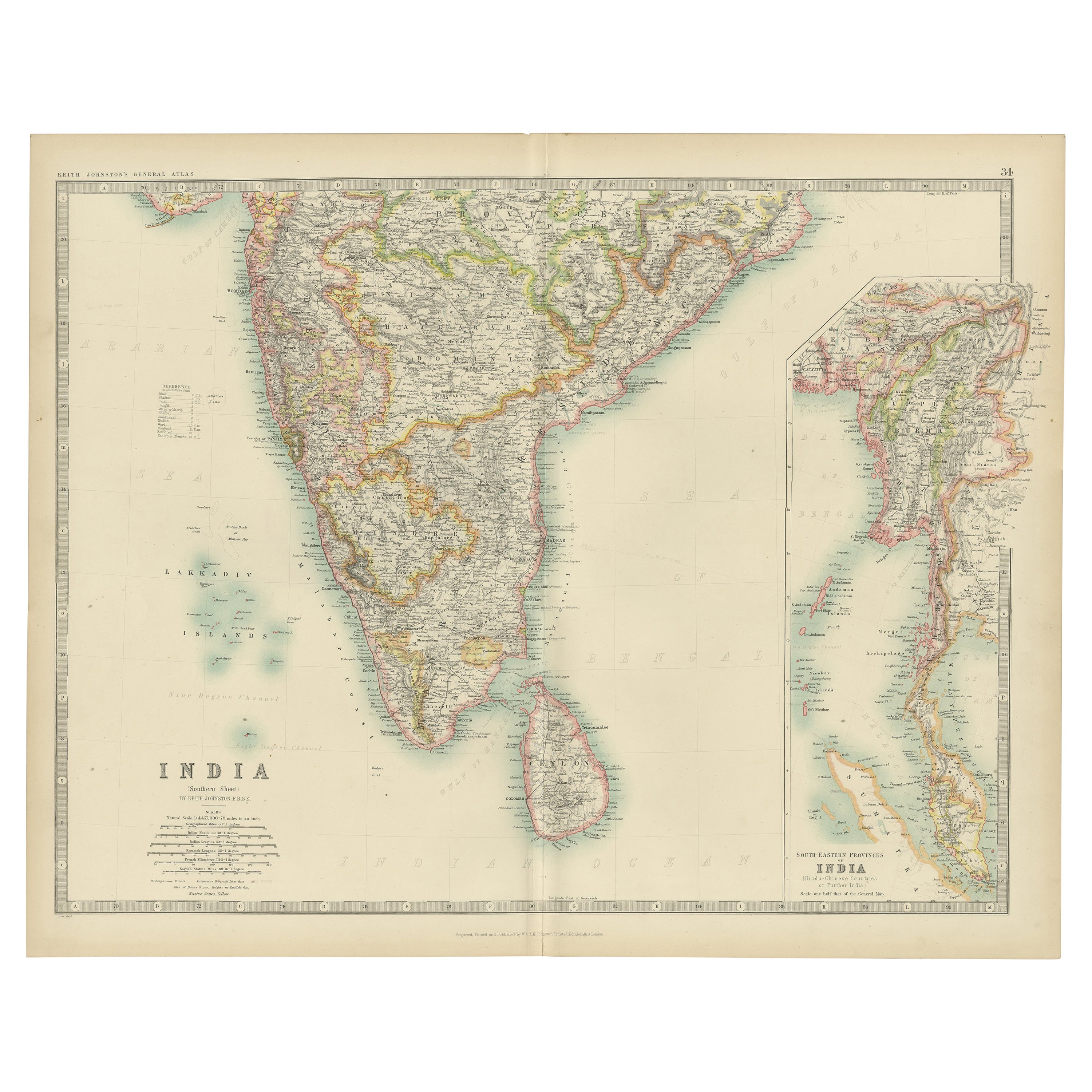
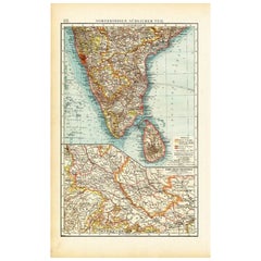
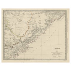
Antique Map of Southern India and South Eastern Provinces, 1903
Acerca del artículo
Title: Antique Map of Southern India and South Eastern Provinces, 1903, with Intricate Detail
Description:
This antique map, titled "India (Southern Sheet) and the South Eastern Provinces," was engraved and published in 1903 by W. & A.K. Johnston in Edinburgh and London. It provides a beautiful and detailed depiction of the southern part of the Indian subcontinent and the southeastern provinces of what is now Myanmar (Burma).
The map is delicately colored in soft pastel shades to highlight provincial and regional boundaries, illustrating the rich geographical and cultural diversity of the region. Major cities, rivers, mountain ranges, and coastal features are marked with precision, reflecting the cartographic skill and artistry of Johnston’s team. The inset map of the South Eastern Provinces provides a closer look at the territories of Burma and its relationship to the Indian subcontinent.
This map captures the dynamic interplay between ancient cultures and British colonial influence at the turn of the 20th century, offering a fascinating window into an era of significant political and social change. The careful engraving and elegant typography make this map not just a historical document, but also a work of art that celebrates the beauty and complexity of southern Asia.
For collectors, historians, and lovers of Indian history and culture, this map is a testament to a time of exploration, trade, and cultural exchange, showcasing the enduring legacy of these lands at the crossroads of empires.
Condition report:
This map is in very good antique condition, with minor age-related foxing and gentle toning along the edges. The colors remain vibrant and the paper is stable and well-preserved.
Framing tips:
A classic wooden frame in walnut or cherry will enhance the warm pastel tones and intricate detailing of the map. Use a cream or off-white matting to highlight the refined linework and create a sophisticated, timeless focal point for any home, study, or library.
- Dimensiones:Altura: 36,8 cm (14,49 in)Anchura: 47 cm (18,51 in)Profundidad: 0,2 mm (0,01 in)
- Materiales y técnicas:
- Época:
- Fecha de fabricación:1903
- Estado:This map is in very good antique condition, with minor age-related foxing and gentle toning along the edges. The colors remain vibrant and the paper is stable and well-preserved. Folding line as issued.
- Ubicación del vendedor:Langweer, NL
- Número de referencia:Vendedor: BG-13577-291stDibs: LU3054345262582
Sobre el vendedor
5,0
Vendedor reconocido
Estos prestigiosos vendedores son líderes del sector y representan el escalón más alto en cuanto a calidad y diseño de artículos.
Vendedor Oro
Vendedores premium que mantienen una calificación de +4,3 y tiempos de respuesta de 24 horas
Establecido en 2009
Vendedor de 1stDibs desde 2017
2462 ventas en 1stDibs
Tiempo de respuesta usual: <1 hora
- EnvíoRecuperando presupuesto…Envío desde: Langweer, Países Bajos
- Política de devolución
Partes de esta página se han traducido automáticamente. 1stDibs no puede garantizar la exactitud de las traducciones. El inglés es el idioma predeterminado de este sitio web.
Garantía de autenticidad
En el improbable caso de que haya algún problema con la autenticidad de un artículo, ponte en contacto con nosotros en un plazo de 1 año para recibir un reembolso total. DetallesGarantía de devolución de dinero
Si tu artículo no es como se describe, sufre daños durante el transporte o no llega, ponte en contacto con nosotros en un plazo de 7 días para recibir un reembolso total. DetallesCancelación dentro de las 24 horas
Tienes un período de gracia de 24 horas para reconsiderar tu compra, sin preguntas.Vendedores profesionales aprobados
Nuestros vendedores de primera clase deben cumplir estrictos estándares de servicio para mantener la integridad de nuestros anuncios.Garantía de igualación de precios
Si encuentras que un vendedor publicó el mismo artículo por un precio menor en otro lado, igualaremos ese precio.Entrega global de confianza
Nuestra red de transporte de primera ofrece opciones de envío especializado en todo el mundo, que incluye envío personalizado.Más de este vendedor
Ver todoMapa antiguo del sur de la India por Andree, 1904
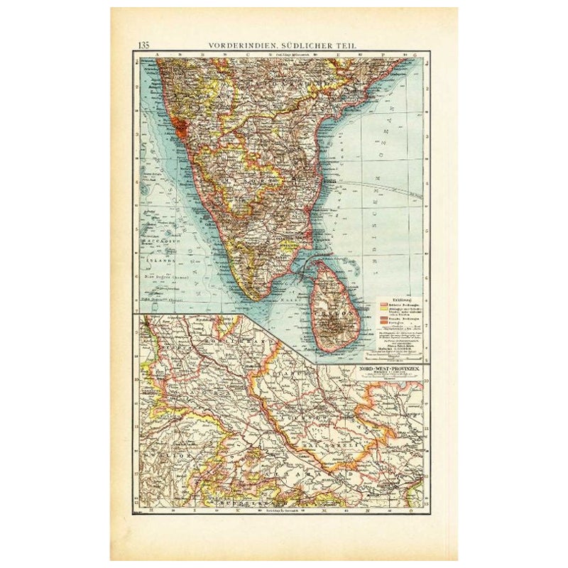
"Mapa antiguo titulado 'Vorderindien, sudlicher Teil'. Mapa de la India, parte sur. Este mapa procede de "Andrees Allgemeiner Handatlas in 126 Haupt-Und 139 Nebenkarten", Bielefeld; ...
Categoría
siglo XX, Mapas
Materiales
Papel
68 US$ Precio de venta
Descuento del 20 %
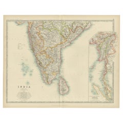
Mapa antiguo de la India ( Sur ) por Johnston (1909)
Mapa antiguo titulado "India". Mapa antiguo original de la India Hoja Sur. Con recuadros de mapas de las provincias del sudeste de la India. Este mapa procede del "Atlas Real de Geog...
Categoría
principios del siglo XX, Mapas
Materiales
Papel
233 US$ Precio de venta
Descuento del 20 %
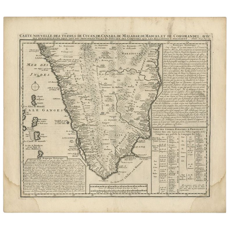
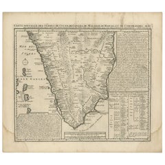
Mapa antiguo de la India meridional por Chatelain, c.1720
"Mapa antiguo titulado 'Carte Nouvelle des Terres de Cucan, de Canara, de Malabar, de Madura, et de Coromandel'. Mapa de la parte meridional de la India, procedente del "Atlas Histor...
Categoría
Antiguo, siglo XVIII, Mapas
Materiales
Papel
289 US$ Precio de venta
Descuento del 20 %
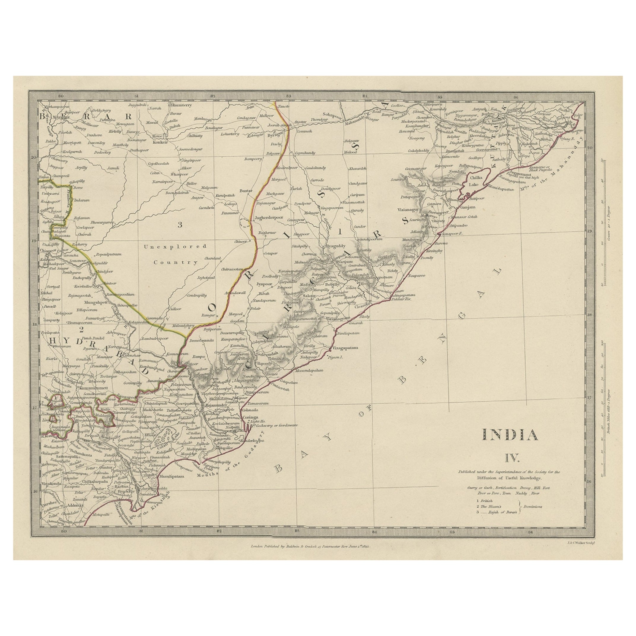
Interesante Mapa Antiguo Detallado de la India Oriental, 1832
Mapa antiguo titulado "India IV". Antiguo mapa grabado en acero de la parte oriental de la India, incluidos el golfo de Bengala, Hydrabad y Masulipatam.
Artistas y grabadores: Gra...
Categoría
Antiguo, siglo XIX, Mapas
Materiales
Papel
270 US$ Precio de venta
Descuento del 20 %
Antique Map of Southern Scotland, 1903, with Coastal and Inland Details
Title: Antique Map of Southern Scotland, 1903, with Coastal and Inland Details
Description:
This exquisite antique map, titled "Scotland (Southern Sheet I)," was engraved and publis...
Categoría
principios del siglo XX, Mapas
Materiales
Papel

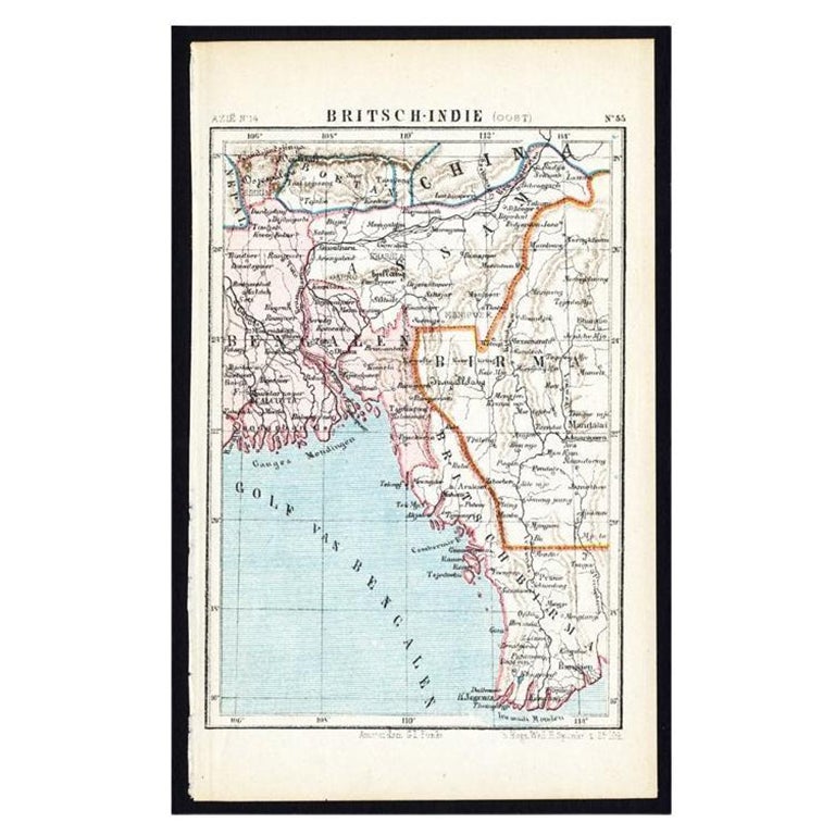
Mapa antiguo de la India oriental por Kuyper, C.1880
Placa 55 : "Britsch-Indie, Oost." (Indias Británicas, Este) (Indias Británicas, Este). Este mapa litografiado procede de: "Wereld-atlas voor Kantoor en Huiskamer" (traducido: Atlas d...
Categoría
Antiguo, siglo XIX, Mapas
Materiales
Papel
También te puede gustar
Mapa Antiguo Original del Estado Americano de Michigan ( Parte Sur ), 1903
Mapa antiguo de Michigan ( Parte sur )
Publicado por A & C Black. 1903
Color original
Buen estado
Sin enmarcar.
Envío gratuito
Categoría
Antiguo, Principios del 1900, Inglés, Mapas
Materiales
Papel

Mapa Antiguo Original del Estado Americano de Ohio ( Parte Sur ), 1903
Mapa antiguo de Ohio ( Parte sur )
Publicado por A & C Black. 1903
Color original
Buen estado
Sin enmarcar.
Envío gratuito
Categoría
Antiguo, Principios del 1900, Inglés, Mapas
Materiales
Papel

Mapa Antiguo Original del Estado Americano de California ( Parte Sur ), 1903
Mapa antiguo de California ( Parte sur )
Publicado por A & C Black. 1903
Color original
Buen estado
Sin enmarcar.
Envío gratuito
Categoría
Antiguo, Principios del 1900, Inglés, Mapas
Materiales
Papel

Mapa Antiguo Original del Estado Americano de Illinois ( Parte Sur ), 1903
Mapa antiguo de Illinois ( Parte sur )
Publicado por A & C Black. 1903
Color original
Buen estado
Sin enmarcar.
Envío gratuito
Categoría
Antiguo, Principios del 1900, Inglés, Mapas
Materiales
Papel

Mapa Antiguo Original del Estado Americano de Missouri ( Parte Sur ), 1903
Mapa antiguo de Missouri ( Parte Sur )
Publicado por A & C Black. 1903
Color original
Buen estado
Sin enmarcar.
Envío gratuito
Categoría
Antiguo, Principios del 1900, Inglés, Mapas
Materiales
Papel

Mapa Antiguo Original del Estado Americano de Pensilvania( Parte Este ), 1903
Antique map of Pennsylvania ( Eastern part )
Published By A & C Black. 1903
Original colour
Good condition
Unframed.
Free shipping
Categoría
Antiguo, Principios del 1900, Inglés, Mapas
Materiales
Papel
