Artículos similares a Antique Map of the Northeast USA - Vibrant 1903 Cartographic Detail
¿Quieres más imágenes o vídeos?
Solicita imágenes o vídeos adicionales al vendedor
1 de 10
Antique Map of the Northeast USA - Vibrant 1903 Cartographic Detail
Acerca del artículo
Map of the Northeastern United States of North America, 1903
This striking antique map titled “United States of North America (North Eastern Sheet)” was created by the renowned Scottish cartographer Keith Johnston and published in 1903. It captures the northeastern portion of the United States, including states such as New York, Pennsylvania, New Jersey, New England, and parts of the Midwest like Ohio and Indiana. With its fine engraving and hand-colored boundaries, this map offers a vivid snapshot of America’s bustling northeastern corridor at the turn of the century.
Notable features include major cities such as New York, Boston, and Philadelphia, as well as detailed renderings of the Great Lakes region, showcasing Lake Michigan, Lake Erie, and Lake Ontario with exceptional precision. The map’s inset of Maine provides additional geographical context for the northernmost reaches of this region, along with a clear delineation of rivers, railways, and mountain ranges. The typography is both elegant and easy to read, displaying Johnston’s trademark clarity and meticulous attention to detail.
The map’s condition is very good to excellent, with a clean impression and minimal age-related toning, adding character without compromising legibility. It’s a wonderful example of the craftsmanship that defined early 20th-century cartography and a superb item for collectors and history enthusiasts.
For framing, consider using a classic wooden or dark frame to complement the antique colors and highlight the intricate details. A neutral matting will help draw the eye to the delicate engraved lines and fine coloration, making this piece an attractive addition to any study, library, or home gallery.
- Dimensiones:Altura: 36,8 cm (14,49 in)Anchura: 47 cm (18,51 in)Profundidad: 0,2 mm (0,01 in)
- Materiales y técnicas:
- Época:
- Fecha de fabricación:1903
- Estado:The map’s condition is excellent, with a clean impression and minimal age-related toning, adding character without compromising legibility.
- Ubicación del vendedor:Langweer, NL
- Número de referencia:Vendedor: BG-13577-451stDibs: LU3054345291742
Sobre el vendedor
5,0
Vendedor reconocido
Estos prestigiosos vendedores son líderes del sector y representan el escalón más alto en cuanto a calidad y diseño de artículos.
Vendedor Oro
Vendedores premium que mantienen una calificación de +4,3 y tiempos de respuesta de 24 horas
Establecido en 2009
Vendedor de 1stDibs desde 2017
2452 ventas en 1stDibs
Tiempo de respuesta usual: <1 hora
- EnvíoRecuperando presupuesto…Envío desde: Langweer, Países Bajos
- Política de devolución
Partes de esta página se han traducido automáticamente. 1stDibs no puede garantizar la exactitud de las traducciones. El inglés es el idioma predeterminado de este sitio web.
Garantía de autenticidad
En el improbable caso de que haya algún problema con la autenticidad de un artículo, ponte en contacto con nosotros en un plazo de 1 año para recibir un reembolso total. DetallesGarantía de devolución de dinero
Si tu artículo no es como se describe, sufre daños durante el transporte o no llega, ponte en contacto con nosotros en un plazo de 7 días para recibir un reembolso total. DetallesCancelación dentro de las 24 horas
Tienes un período de gracia de 24 horas para reconsiderar tu compra, sin preguntas.Vendedores profesionales aprobados
Nuestros vendedores de primera clase deben cumplir estrictos estándares de servicio para mantener la integridad de nuestros anuncios.Garantía de igualación de precios
Si encuentras que un vendedor publicó el mismo artículo por un precio menor en otro lado, igualaremos ese precio.Entrega global de confianza
Nuestra red de transporte de primera ofrece opciones de envío especializado en todo el mundo, que incluye envío personalizado.Más de este vendedor
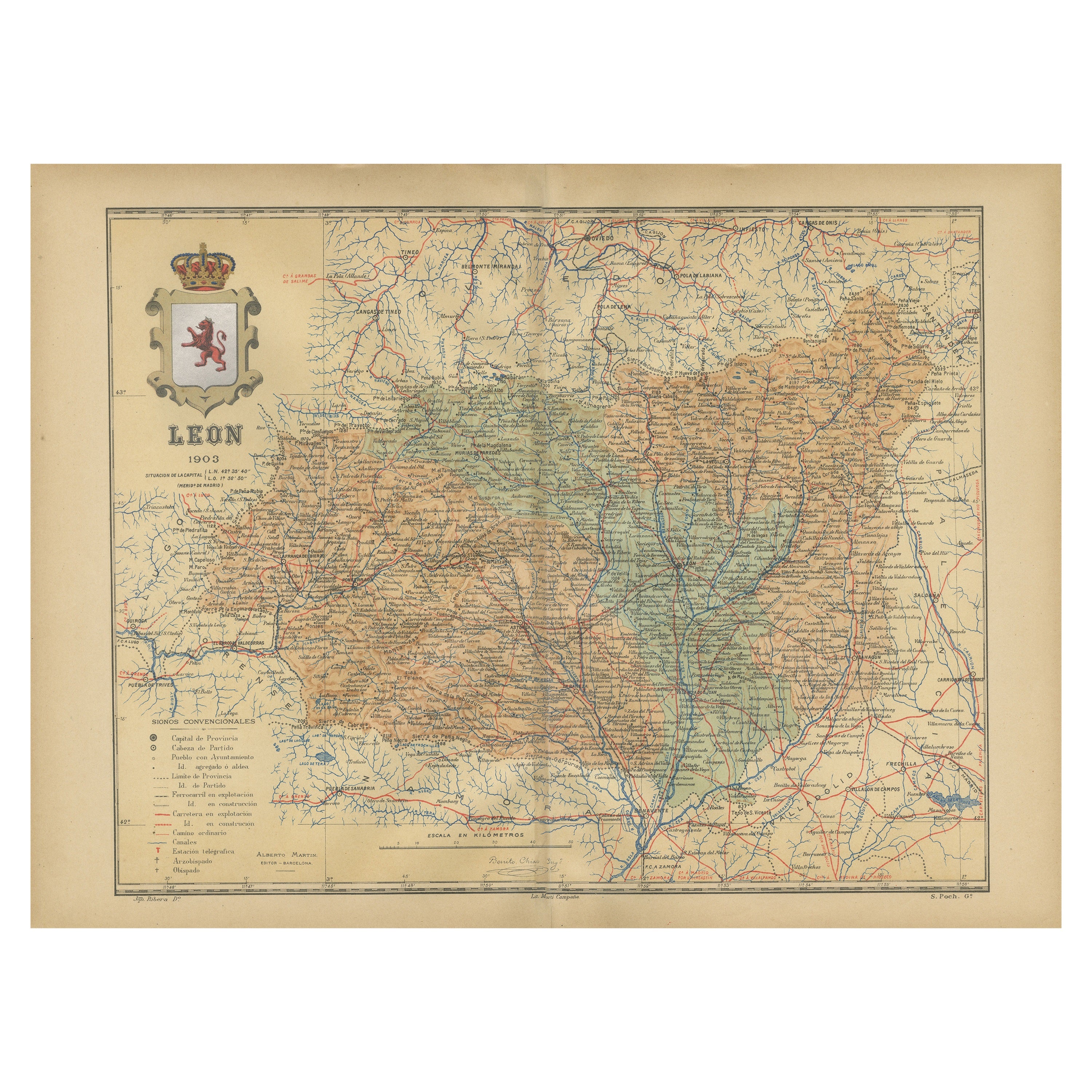
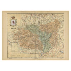
Ver todoLeón 1903: Un Detalle Cartográfico de la Provincia Montañosa de Castilla y León
El mapa representa la provincia de León, que está situada en el noroeste de España y forma parte de la comunidad autónoma de Castilla y León, a partir de 1903. Entre las característi...
Categoría
Antiguo, Principios del 1900, Mapas
Materiales
Papel
270 US$ Precio de venta
Descuento del 20 %
Envío gratuito
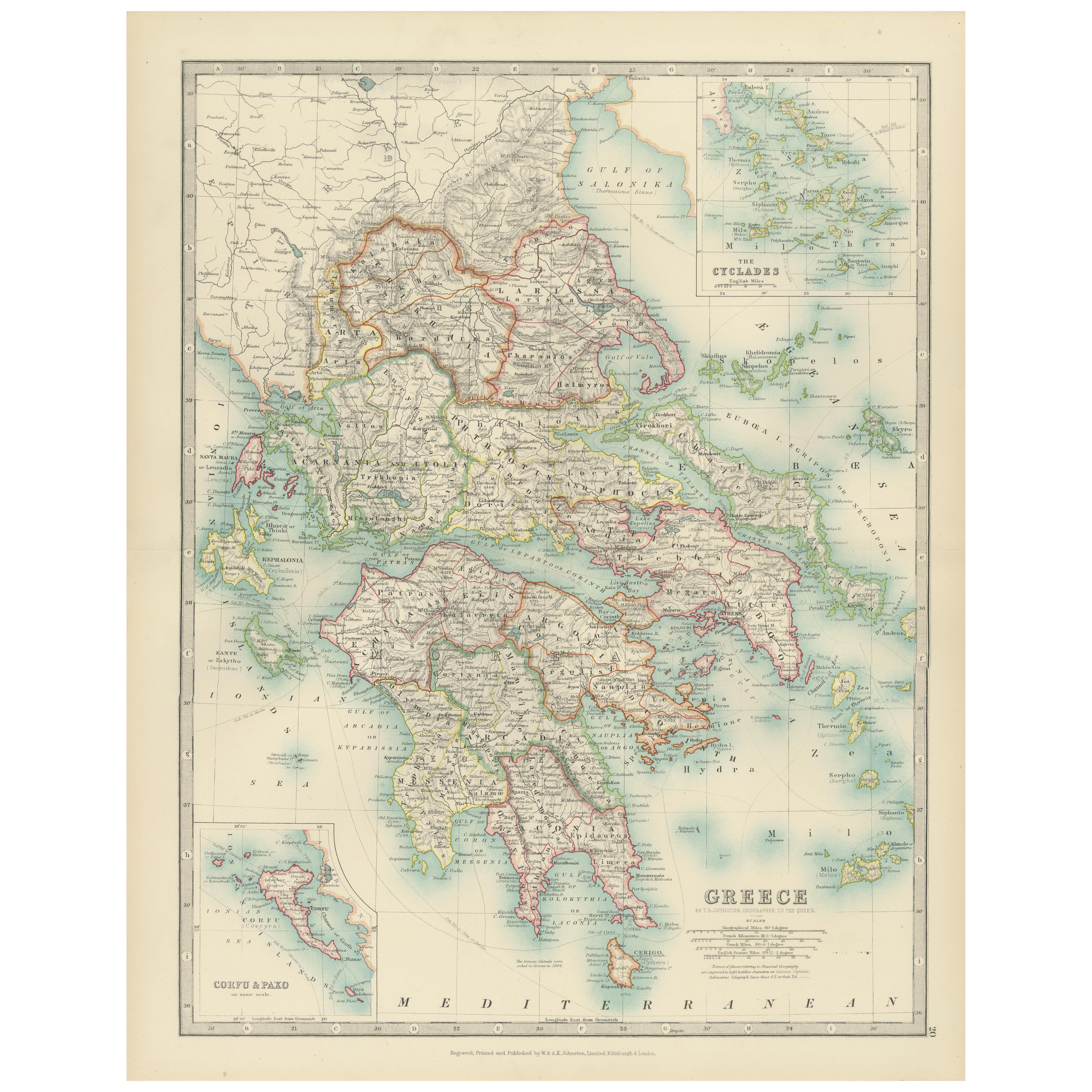
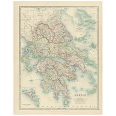
Antique Map of Greece and the Cyclades, 1903, with Many Details and Inset Maps
Title: Antique Map of Greece and the Cyclades, 1903, with Intricate Detail and Inset Maps
Description: This antique map, titled "Greece with Its Islands, Including the Cyclades," wa...
Categoría
principios del siglo XX, Mapas
Materiales
Papel
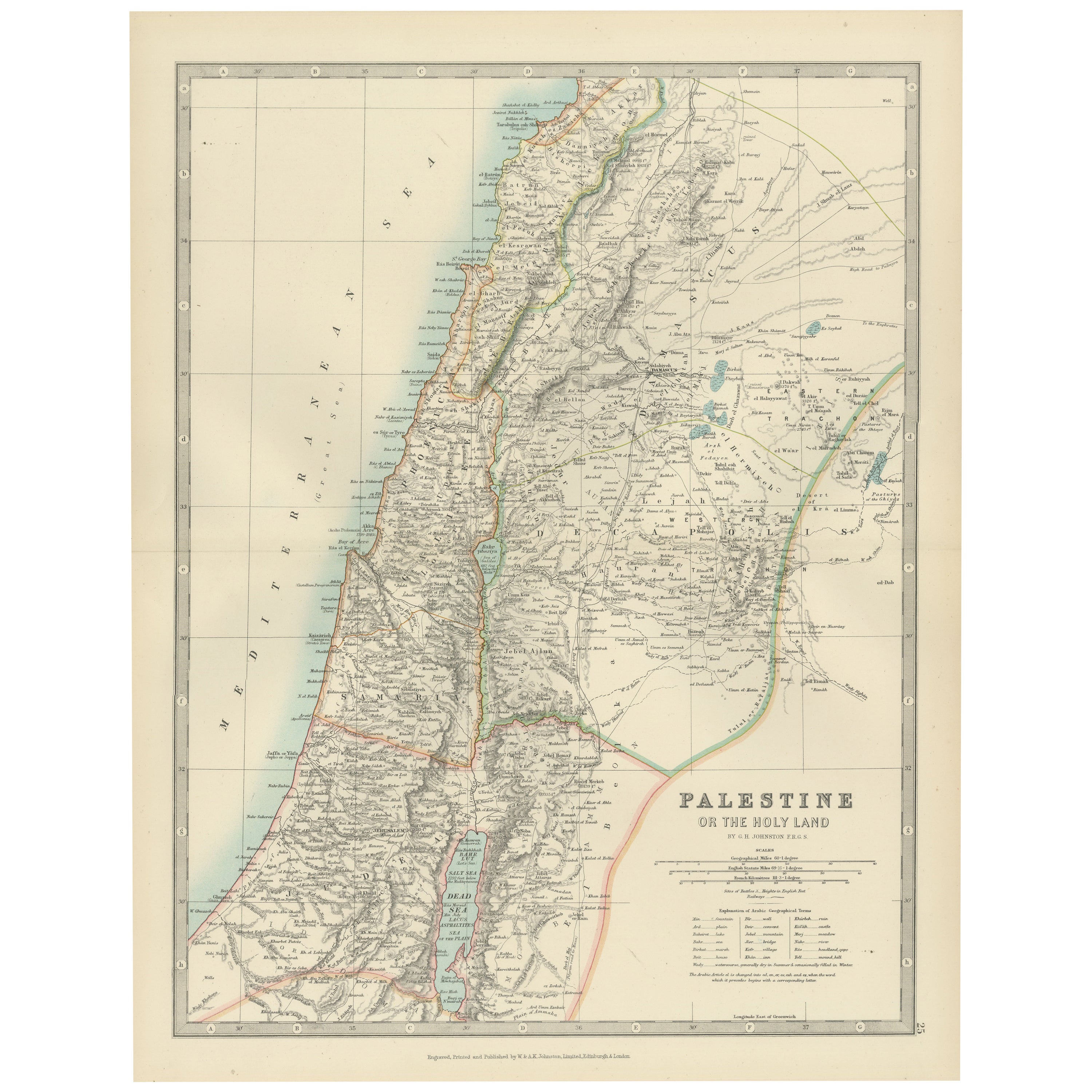
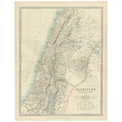
Antique Map of Palestine or The Holy Land, 1903, with Biblical Details
Title: Antique Map of Palestine or The Holy Land, 1903, with Biblical and Geographical Details
Description:
This antique map, titled "Palestine or The Holy Land," was engraved and p...
Categoría
principios del siglo XX, Mapas
Materiales
Papel
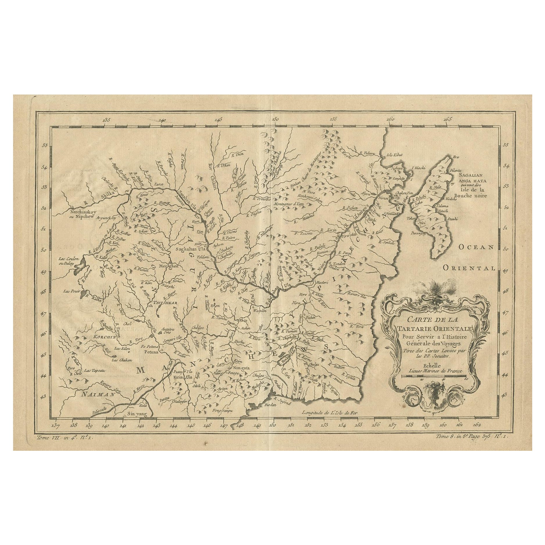
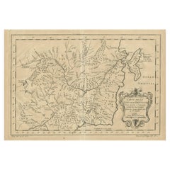
Mapa antiguo de Manchuria y la parte noreste de Tartaria
Mapa antiguo titulado 'Carte de la Tartarie Orientale (..)'. Mapa detallado de Manchuria y de la parte noreste de Tartaria, incluyendo Sagallan Anga Hata--Isla de la Bouche Noire, et...
Categoría
Antiguo, mediados del siglo XVIII, Mapas
Materiales
Papel
270 US$ Precio de venta
Descuento del 20 %
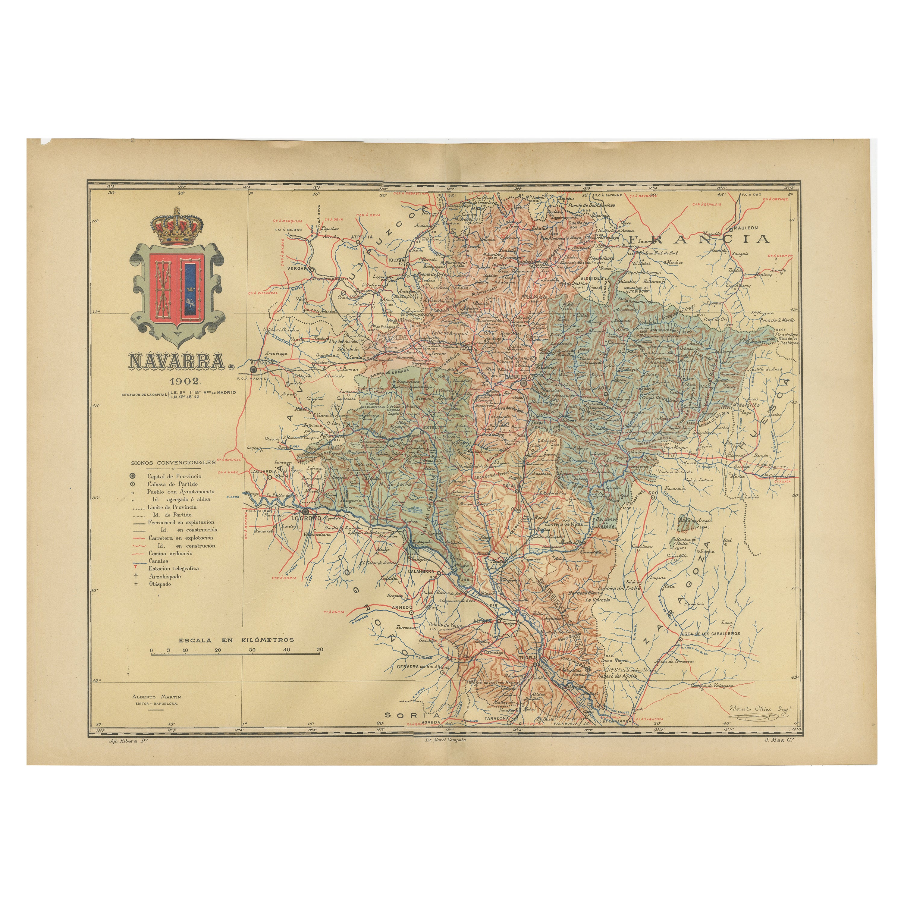
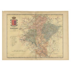
Navarra en detalle cartográfico: Un mapa de 1902 de las encrucijadas del norte de España
El mapa antiguo original en venta muestra la provincia española de Navarra tal y como era en 1902. Aquí tienes una breve descripción y un posible título para el mapa:
Descripción:
-...
Categoría
Antiguo, Principios del 1900, Mapas
Materiales
Papel
317 US$ Precio de venta
Descuento del 20 %
Envío gratuito
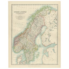
Antique Map of Sweden & Norway, 1903, with Intricate Topographical Detail
Title: Antique Map of Sweden & Norway, 1903, with Intricate Topographical Detail
Description:
This antique map, titled "Sweden & Norway (Scandinavia)," was engraved and published in...
Categoría
principios del siglo XX, Mapas
Materiales
Papel
También te puede gustar
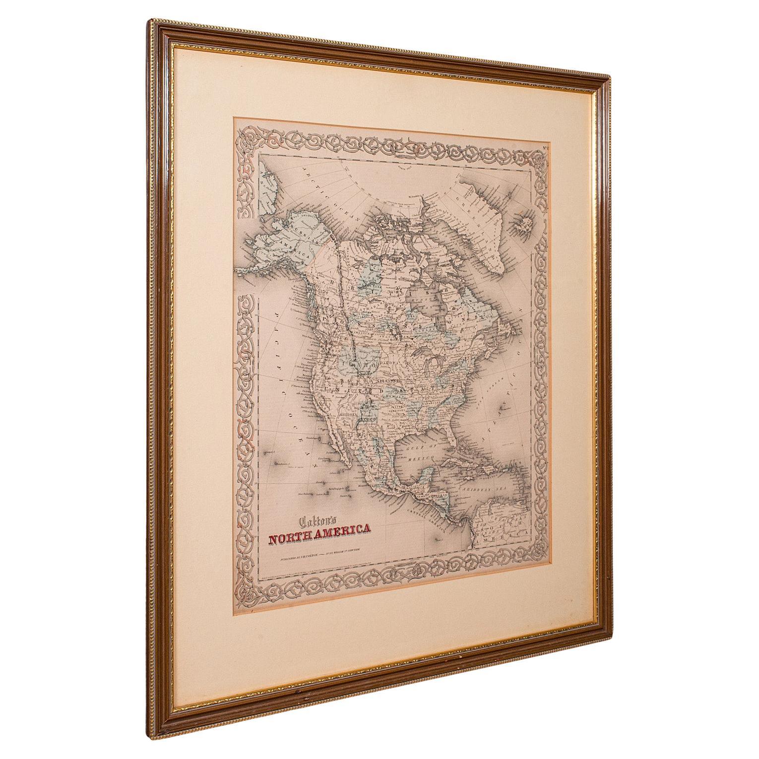
Mapa antiguo de América del Norte, EE.UU., Canadá, México, Cartografía, Colton, Victoriano
Se trata de un mapa antiguo de Norteamérica. EE.UU., grabado litográfico enmarcado de un atlas del continente, obra de JH Colton, de la época victoriana y posterior, hacia 1860.
Fa...
Categoría
Antiguo, Mediados del siglo XIX, Estadounidense, Victoriano, Mapas
Materiales
Papel

Mapa original antiguo del estado norteamericano de Minnesota, 1903
Mapa antiguo de Minnesota
Publicado por A & C Black. 1903
Color original
Buen estado
Sin enmarcar.
Envío gratuito
Categoría
Antiguo, Principios del 1900, Inglés, Mapas
Materiales
Papel

Mapa original antiguo del estado norteamericano de Alabama, 1903
Antique map of Alabama
Published By A & C Black. 1903
Original colour
Good condition
Unframed.
Free shipping
Categoría
Antiguo, Principios del 1900, Inglés, Mapas
Materiales
Papel

Mapa original antiguo del estado norteamericano de Alaska, 1903
Mapa antiguo de Alaska
Publicado por A & C Black. 1903
Color original
Buen estado
Sin enmarcar.
Envío gratuito
Categoría
Antiguo, Principios del 1900, Inglés, Mapas
Materiales
Papel

Mapa original antiguo del estado norteamericano de Nebraska, 1903
Mapa antiguo de Nebraska
Publicado por A & C Black. 1903
Color original
Buen estado
Sin enmarcar.
Envío gratuito
Categoría
Antiguo, Principios del 1900, Inglés, Mapas
Materiales
Papel

Mapa Antiguo Original del Estado Americano de Washington, 1903
Mapa antiguo de Washington
Publicado por A & C Black. 1903
Color original
Buen estado
Sin enmarcar.
Envío gratuito
Categoría
Antiguo, Principios del 1900, Inglés, Mapas
Materiales
Papel
