Artículos similares a Egypt and Lower Nubia, 1903 - Historical Map Highlighting Nile and Red Sea


¿Quieres más imágenes o vídeos?
Solicita imágenes o vídeos adicionales al vendedor
1 de 10
Egypt and Lower Nubia, 1903 - Historical Map Highlighting Nile and Red Sea
Acerca del artículo
Egypt and Lower Nubia, 1903 - Historical Map Highlighting Nile and Red Sea
This beautifully detailed map titled "Egypt, Arabia Petraea, and Lower Nubia" was engraved, printed, and published by W. & A.K. Johnston in Edinburgh and London in 1903. It captures the landscapes and geopolitical boundaries of Egypt and Lower Nubia during a period of intense archaeological exploration and European colonial influence.
The map covers the course of the Nile River as it flows through Egypt and Lower Nubia, from the Mediterranean Sea down to the region of modern-day Sudan. Cities, ancient sites, and topographical features are meticulously labeled, reflecting a deep historical knowledge and an eagerness to catalog the region's landmarks, including the Delta, Cairo, and the ancient ruins along the Nile. The Red Sea’s western coastline is also prominently detailed, showing key ports and trade routes that were vital in connecting Africa, the Middle East, and Asia.
Of particular interest to collectors and historians is how the map captures the geopolitical borders of Egypt as they existed at the turn of the 20th century, reflecting the British occupation that began in 1882. The map's clarity, fine engraving, and subtle color palette make it a compelling piece of cartographic history, perfect for framing and display.
Condition report:
This map is in very good condition for its age, with only minimal signs of wear at the edges and some minor foxing in the margins. The paper is stable and the printed detail remains crisp and vibrant.
Framing tips:
A classic wooden frame in dark walnut or mahogany, paired with a cream or light beige mat, would highlight the map’s soft colors and intricate linework. Ideal for display in an office, library, or gallery, this piece offers both aesthetic appeal and historical significance.
- Dimensiones:Altura: 47 cm (18,51 in)Anchura: 36,8 cm (14,49 in)Profundidad: 0,2 mm (0,01 in)
- Materiales y técnicas:
- Época:
- Fecha de fabricación:1903
- Estado:This map is in very good condition for its age, with only minimal signs of wear at the edges and some minor foxing in the margins. The paper is stable and the printed detail remains crisp and vibrant.
- Ubicación del vendedor:Langweer, NL
- Número de referencia:Vendedor: BG-13577-381stDibs: LU3054345272022
Sobre el vendedor
5,0
Vendedor reconocido
Estos prestigiosos vendedores son líderes del sector y representan el escalón más alto en cuanto a calidad y diseño de artículos.
Vendedor Oro
Vendedores premium que mantienen una calificación de +4,3 y tiempos de respuesta de 24 horas
Establecido en 2009
Vendedor de 1stDibs desde 2017
2452 ventas en 1stDibs
Tiempo de respuesta usual: <1 hora
- EnvíoRecuperando presupuesto…Envío desde: Langweer, Países Bajos
- Política de devolución
Partes de esta página se han traducido automáticamente. 1stDibs no puede garantizar la exactitud de las traducciones. El inglés es el idioma predeterminado de este sitio web.
Garantía de autenticidad
En el improbable caso de que haya algún problema con la autenticidad de un artículo, ponte en contacto con nosotros en un plazo de 1 año para recibir un reembolso total. DetallesGarantía de devolución de dinero
Si tu artículo no es como se describe, sufre daños durante el transporte o no llega, ponte en contacto con nosotros en un plazo de 7 días para recibir un reembolso total. DetallesCancelación dentro de las 24 horas
Tienes un período de gracia de 24 horas para reconsiderar tu compra, sin preguntas.Vendedores profesionales aprobados
Nuestros vendedores de primera clase deben cumplir estrictos estándares de servicio para mantener la integridad de nuestros anuncios.Garantía de igualación de precios
Si encuentras que un vendedor publicó el mismo artículo por un precio menor en otro lado, igualaremos ese precio.Entrega global de confianza
Nuestra red de transporte de primera ofrece opciones de envío especializado en todo el mundo, que incluye envío personalizado.Más de este vendedor
Ver todoGran Mapa Antiguo del Valle del Bajo Nilo, incluyendo Egipto y Nubia, 1842
Mapa antiguo titulado "Carte de l'Égypte, de la Nubie, de l'Abissinie". Mapa de Egipto, que abarca el valle inferior del Nilo, incluyendo Egipto y Nubia. Este mapa procede del "Atlas...
Categoría
Antiguo, siglo XIX, Mapas
Materiales
Papel

420 US$ Precio de venta
Descuento del 20 %
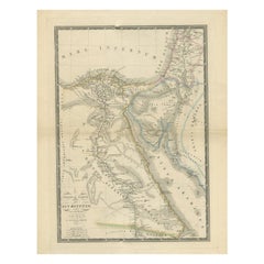
Mapa antiguo de Egipto, Arabia Petraea y Baja Nubia por Johnston '1909
Mapa antiguo titulado "Egipto, Arabia Petraea y Baja Nubia". Mapa antiguo original de Egipto, Arabia Petraea y Baja Nubia. Con mapas de Alejandría, El Cairo y el Canal de Suez. Este ...
Categoría
principios del siglo XX, Mapas
Materiales
Papel

219 US$ Precio de venta
Descuento del 24 %
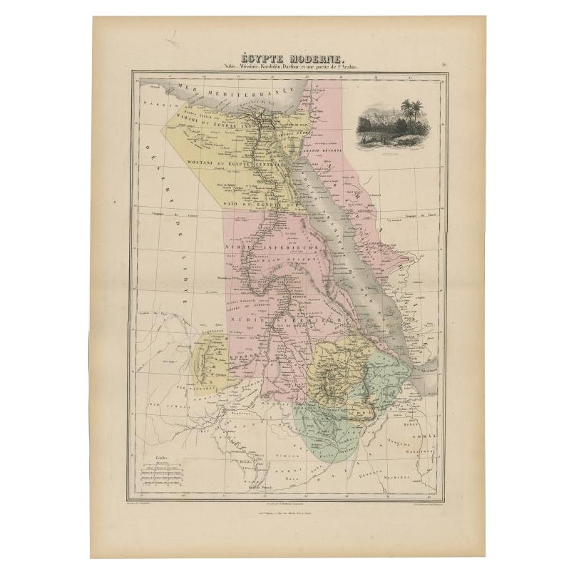
Mapa antiguo del Nilo, Egipto, Nubia y Abisinia con Jerusalén, 1880
Mapa antiguo titulado "Égypte Moderne". Antiguo mapa de Egipto, Nubia y Abisinia (Etiopía), Kordofán y Darfur (partes de Sudán), así como parte de Arabia. Con viñeta decorativa de Je...
Categoría
Antiguo, siglo XIX, Mapas
Materiales
Papel

Mapa antiguo del Nilo, Egipto y el Mar Rojo por Bachiene, 1765
Mapa antiguo titulado "De XIde Landkaart verbeeldende Egypte en de Woestyne der Schelf-Zee (..)". Mapa del Egipto bíblico y del Mar Rojo. Con cartela en el título, rosa de los viento...
Categoría
Antiguo, siglo XVIII, Mapas
Materiales
Papel

163 US$ Precio de venta
Descuento del 20 %
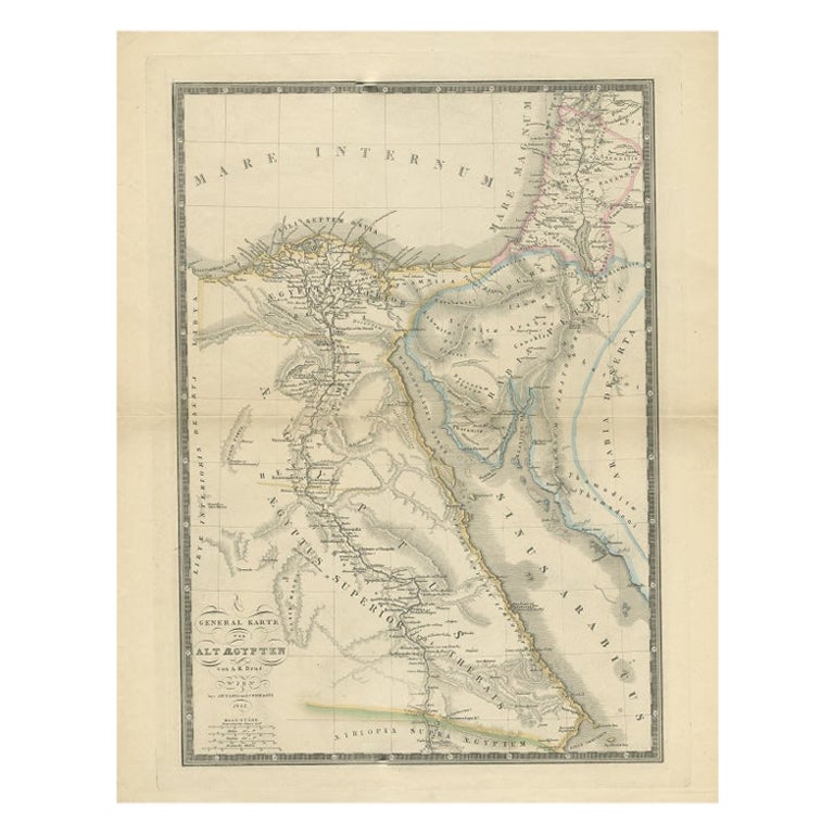
Mapa antiguo del Antiguo Egipto que representa también el río Nilo y el Mar Rojo, 1845
Mapa antiguo Egipto titulado 'General Karte von Alt Aegypten von A.H. Brué'. Gran mapa de Egipto que representa también el río Nilo y el Mar Rojo. Fuente desconocida, por determinar....
Categoría
Antiguo, siglo XIX, Mapas
Materiales
Papel
233 US$ Precio de venta
Descuento del 20 %
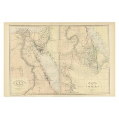
Antiguo Mapa Decorativo Coloreado Egipto, Nubia, Abisinia y más, 1882
Esta imagen contiene dos mapas, el de la izquierda titulado "Egipto" y el de la derecha "Nubia, Abisinia y las tierras adyacentes". Estos mapas destacan el Valle del Nilo y las regio...
Categoría
Antiguo, Década de 1880, Mapas
Materiales
Papel
219 US$ Precio de venta
Descuento del 24 %
Envío gratuito
También te puede gustar
2 Grandes Vols Libro de Referencia Antiguo, Egipto - Histórico y Pintoresco, Inglés
Se trata de 2 grandes volúmenes del antiguo libro de referencia "Egipto - Descriptivo, Histórico y Pintoresco" de G. Ebers. Traducción inglesa de Clara Bell, con ilustraciones, de la...
Categoría
Antiguo, Fines del siglo XIX, Británico, Victoriano, Libros
Materiales
Textil, Papel
Mapa litográfico del siglo XIX del Bajo Manhattan, Nueva York
Mapa coloreado a mano de 1859 del Bajo Manhattan o Nueva Amsterdam por George H. Moore.
Categoría
Antiguo, siglo XIX, Inglés, Arte popular, Mapas
Materiales
Papel

Mapa vintage sobredimensionado de Nueva York, Lower Manhattan, 1840
Reproducción impresa vintage de finales del siglo XX de la ciudad de Nueva York, con el bajo Manhattan en 1840.
Categoría
finales del siglo XX, Victoriano, Mapas
Materiales
Papel

800 US$ Precio de venta
Descuento del 20 %
Mapa original antiguo del estado norteamericano de Minnesota, 1903
Mapa antiguo de Minnesota
Publicado por A & C Black. 1903
Color original
Buen estado
Sin enmarcar.
Envío gratuito
Categoría
Antiguo, Principios del 1900, Inglés, Mapas
Materiales
Papel

Mapa original antiguo del estado norteamericano de Alabama, 1903
Antique map of Alabama
Published By A & C Black. 1903
Original colour
Good condition
Unframed.
Free shipping
Categoría
Antiguo, Principios del 1900, Inglés, Mapas
Materiales
Papel

Mapa original antiguo del estado norteamericano de Alaska, 1903
Mapa antiguo de Alaska
Publicado por A & C Black. 1903
Color original
Buen estado
Sin enmarcar.
Envío gratuito
Categoría
Antiguo, Principios del 1900, Inglés, Mapas
Materiales
Papel
