Artículos similares a Map of Ardèche France with Annonay and Vineyards by Vuillemin, 19th c


¿Quieres más imágenes o vídeos?
Solicita imágenes o vídeos adicionales al vendedor
1 de 11
Map of Ardèche France with Annonay and Vineyards by Vuillemin, 19th c
120 €IVA incluido
Acerca del artículo
Map of Ardèche France with Annonay and Vineyards by Vuillemin, 19th c
This beautifully engraved 19th-century map of Ardèche, a department in southeastern France, comes from Alexandre Vuillemin’s *Nouvel Atlas Illustré*, published in Paris by Migeon. The map offers a detailed and artistic representation of the region, enhanced by vignettes, coats of arms, and historical references that highlight Ardèche’s cultural and natural richness.
The map presents the department’s full geographical scope with towns, rivers, and road networks, bordered by hand-applied yellow watercolor. Key locations such as Annonay, Privas, and Aubenas are clearly marked. The engraving also depicts the rugged terrain for which the Ardèche is well known, including the mountainous Massif Central and deep river gorges. In the upper left is a vignette of the town of Annonay, famous as the birthplace of the Montgolfier brothers, pioneers of balloon flight. Below that is a depiction of the natural stone arch of the Pont d’Arc, one of the most iconic landmarks in the region.
In the lower right corner, a striking scene depicts Joseph Marie Jacquard presenting his invention of the Jacquard loom, symbolizing Ardèche’s historical contributions to the textile industry. Jacquard’s automated loom was a key innovation in the development of modern weaving.
Ardèche is also a celebrated wine-producing region, especially in the southern part of the department near the Rhône Valley. The area is known for its rustic, characterful wines, including red blends made from Grenache, Syrah, and Merlot, as well as fresh white wines from Viognier and Chardonnay grapes. These wines are often labeled under the Côtes du Vivarais and Coteaux de l’Ardèche designations. The region’s climate and diverse terroirs make it an increasingly respected area within the Rhône wine landscape.
Alexandre Vuillemin, a skilled 19th-century French cartographer, was renowned for blending geography with artistic and cultural elements in his maps. His works were both decorative and informative, aimed at a growing educated public. The publisher, Migeon, was known for high-quality atlases that brought historical and geographic knowledge to a broad audience.
Condition summary:
Excellent impression with mild toning to the edges and a few small, scattered foxing marks. The hand-coloring remains vivid and the engraving is sharp and detailed.
Framing tips:
A classic dark wood or olive-toned frame will highlight the natural character of the Ardèche region. A warm off-white or light tan mat works well to emphasize the yellow hand-coloring. Use UV-protective glass for preservation.
- Dimensiones:Altura: 26,1 cm (10,28 in)Anchura: 32,5 cm (12,8 in)Profundidad: 0,2 mm (0,01 in)
- Materiales y técnicas:Papel,Grabado
- Lugar de origen:
- Época:
- Fecha de fabricación:circa 1850
- Estado:Excellent impression with mild toning to the edges and a few small, scattered foxing marks. The hand-coloring remains vivid and the engraving is sharp and detailed.
- Ubicación del vendedor:Langweer, NL
- Número de referencia:Vendedor: BG-13331-61stDibs: LU3054345359162
Sobre el vendedor
5,0
Vendedor reconocido
Estos prestigiosos vendedores son líderes del sector y representan el escalón más alto en cuanto a calidad y diseño de artículos.
Vendedor Platino
Vendedores premium con una calificación de +4,7 y tiempos de respuesta de 24 horas
Establecido en 2009
Vendedor de 1stDibs desde 2017
2656 ventas en 1stDibs
Tiempo de respuesta usual: <1 hora
- EnvíoRecuperando presupuesto…Envío desde: Langweer, Países Bajos
- Política de devolución
Partes de esta página se han traducido automáticamente. 1stDibs no puede garantizar la exactitud de las traducciones. El inglés es el idioma predeterminado de este sitio web.
Garantía de autenticidad
En el improbable caso de que haya algún problema con la autenticidad de un artículo, ponte en contacto con nosotros en un plazo de 1 año para recibir un reembolso total. DetallesGarantía de devolución de dinero
Si tu artículo no es como se describe, sufre daños durante el transporte o no llega, ponte en contacto con nosotros en un plazo de 7 días para recibir un reembolso total. DetallesCancelación dentro de las 24 horas
Tienes un período de gracia de 24 horas para reconsiderar tu compra, sin preguntas.Vendedores profesionales aprobados
Nuestros vendedores de primera clase deben cumplir estrictos estándares de servicio para mantener la integridad de nuestros anuncios.Garantía de igualación de precios
Si encuentras que un vendedor publicó el mismo artículo por un precio menor en otro lado, igualaremos ese precio.Entrega global de confianza
Nuestra red de transporte de primera ofrece opciones de envío especializado en todo el mundo, que incluye envío personalizado.Más de este vendedor
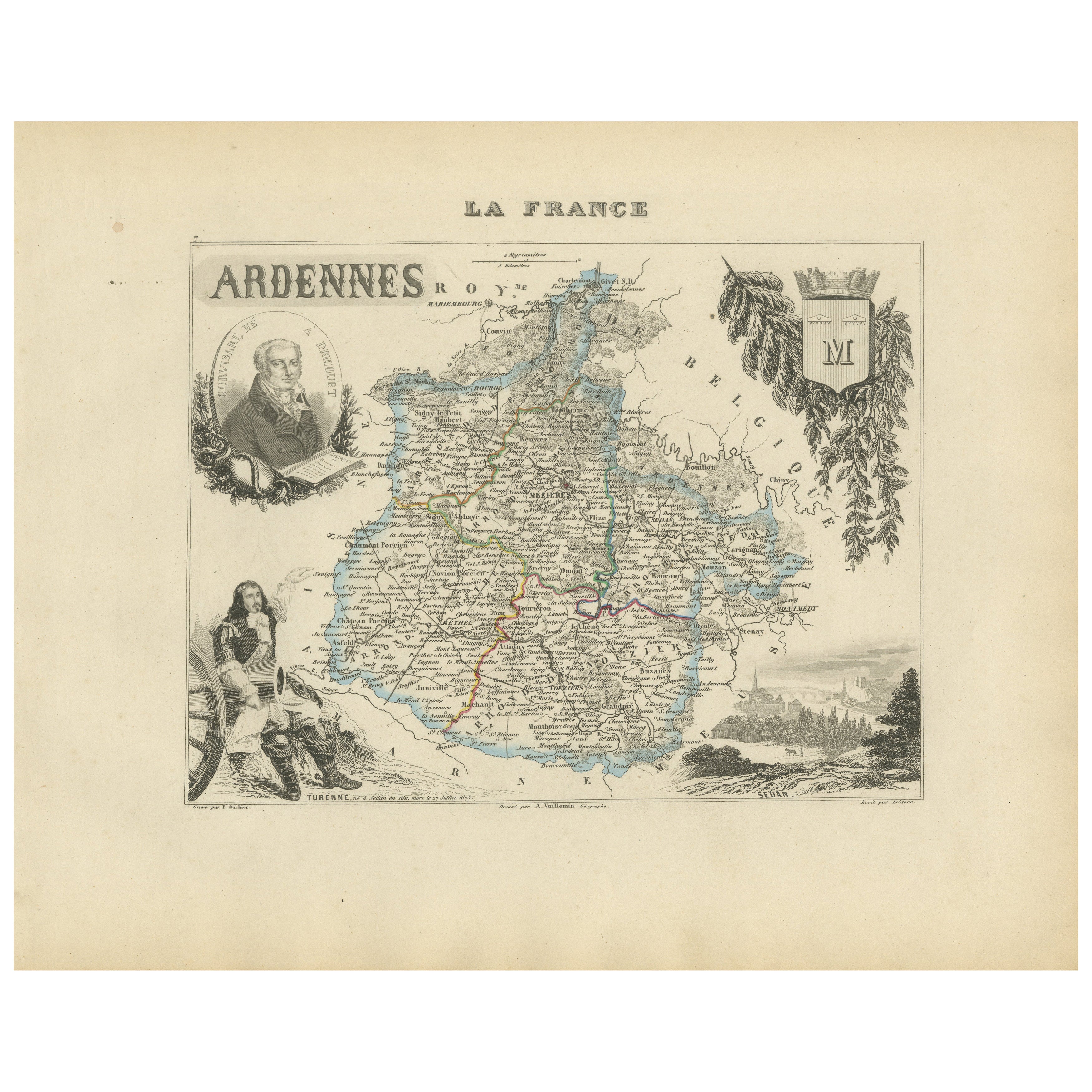
Ver todoMap of Ardennes France with Sedan and Military History by Vuillemin, c.1850
Map of Ardennes France with Sedan and Military History by Vuillemin, 19th c
Description:
This detailed and decorative 19th-century map of the Ardennes department in northeastern Fra...
Categoría
Antiguo, Mediados del siglo XIX, Francés, Mapas
Materiales
Papel
Map of Aisne France with Soissons and Champagne Vineyards by Vuillemin, 19th c
Map of Aisne France with Soissons and Champagne Vineyards by Vuillemin, 19th c
Description:
This richly detailed 19th-century engraved and hand-colored map of the department of Aisn...
Categoría
Antiguo, Mediados del siglo XIX, Francés, Mapas
Materiales
Papel

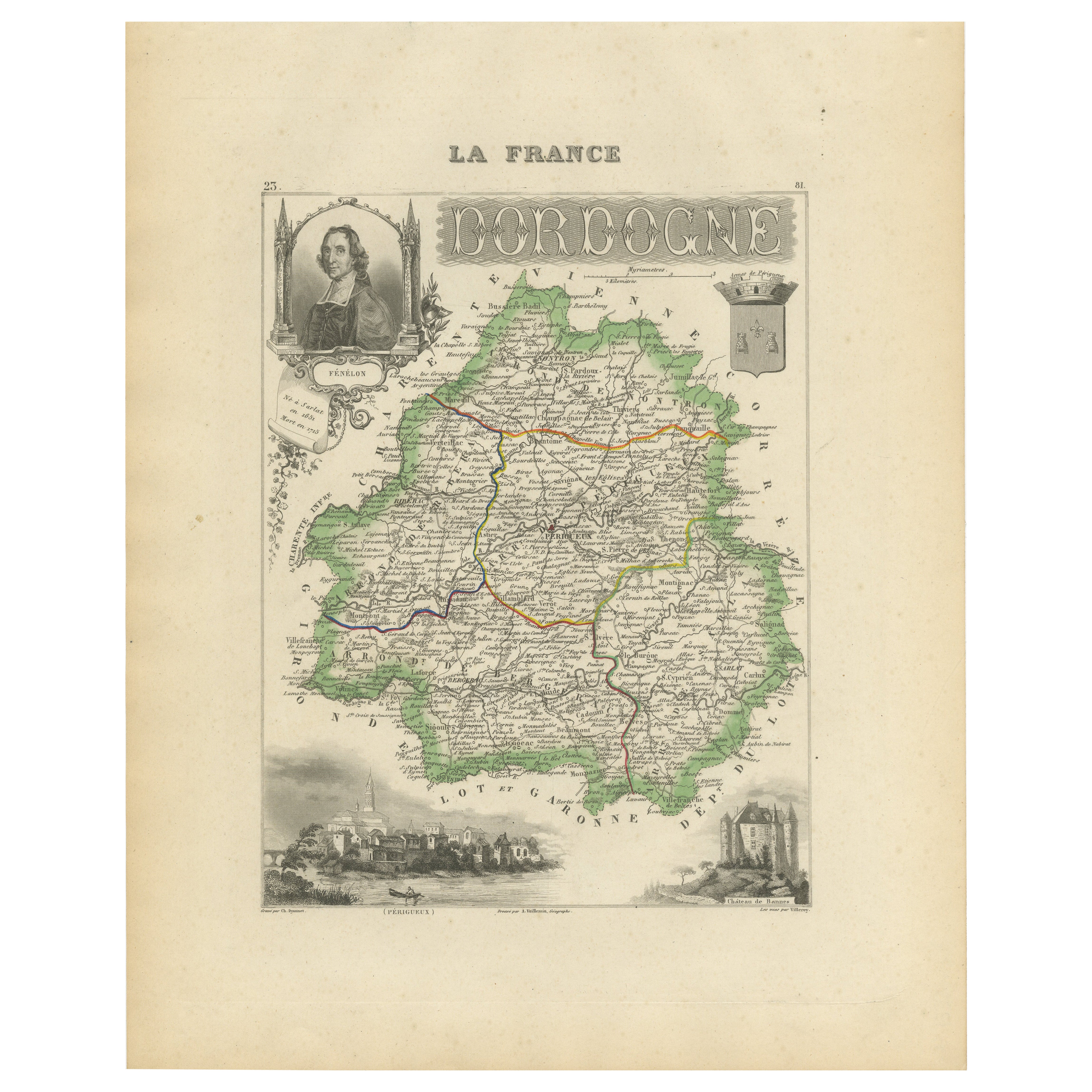
Map of Dordogne France with Périgueux and Château de Jumilhac, 19th Century
Map of Dordogne France with Périgueux and Château de Jumilhac, 19th Century
Description:
This richly detailed 19th-century map of the Dordogne department in southwestern France was ...
Categoría
Antiguo, Mediados del siglo XIX, Francés, Mapas
Materiales
Papel
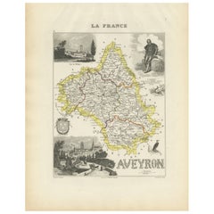
Map of Aveyron France with Rodez, Millau and Wine Routes, 19th Century
Map of Aveyron France with Rodez, Millau and Wine Routes, 19th Century
Description:
This detailed and decorative 19th-century map of Aveyron, a department in southern France, was dr...
Categoría
Antiguo, Mediados del siglo XIX, Francés, Mapas
Materiales
Papel
Map of Allier France with Saint-Pourçain Wine Region by Vuillemin, 19th c
Map of Allier France with Saint-Pourçain Wine Region by Vuillemin, 19th c
This decorative 19th-century map of Allier, a central department of France, comes from the celebrated Nouve...
Categoría
Antiguo, Mediados del siglo XIX, Francés, Mapas
Materiales
Papel

Mapa de Gers, Francia, con Auch y la región vinícola de Armagnac, por Vuillemin, s. XIX
Mapa de Gers, Francia, con Auch y la región vinícola de Armagnac, por Vuillemin, s. XIX
Este mapa grabado y coloreado a mano del siglo XIX del departamento de Gers, en el suroeste d...
Categoría
Antiguo, Mediados del siglo XIX, Francés, Mapas
Materiales
Papel

También te puede gustar
Aude, Francia. Mapa antiguo de un departamento francés, 1856
Por Victor Levasseur
"Dept. de L' Aude", grabado en acero con contorno original coloreado a mano., 1856, del "Atlas National Illustre" de Levasseur.
Esta zona de Francia es famosa por su gran variedad ...
Categoría
siglo XIX, Naturalista, Impresiones de paisajes
Materiales
Grabado

Var, Francia. Mapa antiguo de un departamento francés, 1856
Por Victor Levasseur
Dept. du Var", grabado en acero con contorno original coloreado a mano, 1856, del Atlas National Illustre de Levasseur.
Var abarca el corazón de la Costa Azul, e incluye las ciudad...
Categoría
siglo XIX, Naturalista, Impresiones de paisajes
Materiales
Grabado

Lozere, Francia. Mapa antiguo de un departamento francés, 1856
Por Victor Levasseur
Dept. de La Lozere", grabado en acero con contorno original coloreado a mano, 1856, del "Atlas National Illustre" de Levasseur.
Esta remota zona montañosa de Languedoc es rural, po...
Categoría
siglo XIX, Naturalista, Impresiones de paisajes
Materiales
Grabado

L'Isere, Francia. Mapa antiguo del departamento francés, 1856
Por Victor Levasseur
Dept. de L'Isere", grabado en acero con contorno original coloreado a mano, 1856, del "Atlas National Illustre" de Levasseur.
Esta zona es conocida por su producción de Bleu du Ver...
Categoría
siglo XIX, Naturalista, Impresiones de paisajes
Materiales
Grabado

Aube, Francia. Mapa antiguo de un departamento francés, 1856
Por Victor Levasseur
Dept. de L'Aube", grabado en acero con contorno original coloreado a mano, 1856, del "Atlas National Illustre" de Levasseur.
Esta zona de Francia es conocida por su producción de C...
Categoría
siglo XIX, Naturalista, Impresiones de paisajes
Materiales
Grabado

L'Herault, Francia. Mapa antiguo de un departamento francés, 1856
Por Victor Levasseur
Dept. de Saone et Loire", grabado en acero con contorno original coloreado a mano, 1856, del Atlas National Illustre de Levasseur.
Esta zona alberga una gran variedad de viñedos y ...
Categoría
siglo XIX, Naturalista, Impresiones de paisajes
Materiales
Grabado
