Artículos similares a Map of Aube France with Troyes and Champagne Wine Region, 19th Century


¿Quieres más imágenes o vídeos?
Solicita imágenes o vídeos adicionales al vendedor
1 de 10
Map of Aube France with Troyes and Champagne Wine Region, 19th Century
120 €IVA incluido
Acerca del artículo
Map of Aube France with Troyes and Champagne Vineyards by Vuillemin, 19th c
Description:
This 19th-century map of the Aube department in the Grand Est region of northeastern France was engraved by Alexandre Vuillemin and published by Migeon in Paris as part of the Nouvel Atlas Illustré. Combining fine cartography with historical and cultural illustration, the map offers a visual journey through one of France’s most historically rich and agriculturally significant regions.
Aube is part of the historic Champagne region, and the map clearly displays its towns, rivers, and roadways, all bordered in hand-applied pastel pink. The capital city of Troyes is prominently positioned at the center, surrounded by a dense network of communes. To the right, a finely engraved vignette shows the town of Nogent-sur-Seine, situated along the banks of the river, offering a calm and picturesque atmosphere.
Two prominent portraits are featured in the lower left corner: Denis Diderot, the Enlightenment philosopher and editor of the Encyclopédie, who was born in Langres just outside Aube but is associated with the regional intellectual landscape; and Georges Cuvier, a pioneering naturalist who laid the foundations for paleontology. Their inclusion highlights the region’s contribution to French intellectual and scientific advancement.
Aube plays a major role in France’s wine culture as part of the southern Champagne-producing area. The Côte des Bar, located in the southern part of Aube, is especially known for producing high-quality Pinot Noir grapes, crucial for blending in Champagne production. While less internationally known than the vineyards of Reims and Épernay to the north, the vineyards around Bar-sur-Seine and Bar-sur-Aube have gained increasing recognition for their elegant and expressive sparkling wines.
Alexandre Vuillemin was a leading 19th-century French cartographer celebrated for merging technical accuracy with decorative and educational value. His maps are valued today for their aesthetic qualities and insight into the political and cultural geography of the time. The publisher Migeon specialized in illustrated educational works, bringing finely engraved atlases to a broad audience.
Condition summary:
Very good condition with minimal toning and a few scattered foxing spots, mostly confined to the margins. Original hand coloring remains vibrant and the engraving is clear and sharp.
Framing tips:
This map pairs well with a dark or gold-toned frame. A soft beige or off-white mat will complement the pink border color and engraved details. Use UV-filtering glass for preservation and to maintain the crispness of the print.
- Dimensiones:Altura: 26,1 cm (10,28 in)Anchura: 32,5 cm (12,8 in)Profundidad: 0,2 mm (0,01 in)
- Materiales y técnicas:Papel,Grabado
- Lugar de origen:
- Época:
- Fecha de fabricación:circa 1850
- Estado:Very good condition with minimal toning and a few scattered foxing spots, mostly confined to the margins. Original hand coloring remains vibrant and the engraving is clear and sharp.
- Ubicación del vendedor:Langweer, NL
- Número de referencia:Vendedor: BG-13331-91stDibs: LU3054345359582
Sobre el vendedor
5,0
Vendedor reconocido
Estos prestigiosos vendedores son líderes del sector y representan el escalón más alto en cuanto a calidad y diseño de artículos.
Vendedor Platino
Vendedores premium con una calificación de +4,7 y tiempos de respuesta de 24 horas
Establecido en 2009
Vendedor de 1stDibs desde 2017
2656 ventas en 1stDibs
Tiempo de respuesta usual: <1 hora
- EnvíoRecuperando presupuesto…Envío desde: Langweer, Países Bajos
- Política de devolución
Partes de esta página se han traducido automáticamente. 1stDibs no puede garantizar la exactitud de las traducciones. El inglés es el idioma predeterminado de este sitio web.
Garantía de autenticidad
En el improbable caso de que haya algún problema con la autenticidad de un artículo, ponte en contacto con nosotros en un plazo de 1 año para recibir un reembolso total. DetallesGarantía de devolución de dinero
Si tu artículo no es como se describe, sufre daños durante el transporte o no llega, ponte en contacto con nosotros en un plazo de 7 días para recibir un reembolso total. DetallesCancelación dentro de las 24 horas
Tienes un período de gracia de 24 horas para reconsiderar tu compra, sin preguntas.Vendedores profesionales aprobados
Nuestros vendedores de primera clase deben cumplir estrictos estándares de servicio para mantener la integridad de nuestros anuncios.Garant�ía de igualación de precios
Si encuentras que un vendedor publicó el mismo artículo por un precio menor en otro lado, igualaremos ese precio.Entrega global de confianza
Nuestra red de transporte de primera ofrece opciones de envío especializado en todo el mundo, que incluye envío personalizado.Más de este vendedor
Ver todoMap of Allier France with Saint-Pourçain Wine Region by Vuillemin, 19th c
Map of Allier France with Saint-Pourçain Wine Region by Vuillemin, 19th c
This decorative 19th-century map of Allier, a central department of France, comes from the celebrated Nouve...
Categoría
Antiguo, Mediados del siglo XIX, Francés, Mapas
Materiales
Papel

Map of Aisne France with Soissons and Champagne Vineyards by Vuillemin, 19th c
Map of Aisne France with Soissons and Champagne Vineyards by Vuillemin, 19th c
Description:
This richly detailed 19th-century engraved and hand-colored map of the department of Aisn...
Categoría
Antiguo, Mediados del siglo XIX, Francés, Mapas
Materiales
Papel

Map of Côtes-du-Nord France with Saint-Brieuc and Brittany Coastline, c.1850
Map of Côtes-du-Nord France with Saint-Brieuc and Brittany Coastline, 19th c
Description:
This elegant 19th-century map of Côtes-du-Nord, the historic name for what is now known as ...
Categoría
Antiguo, Mediados del siglo XIX, Francés, Mapas
Materiales
Papel

Mapa de Gers, Francia, con Auch y la región vinícola de Armagnac, por Vuillemin, s. XIX
Mapa de Gers, Francia, con Auch y la región vinícola de Armagnac, por Vuillemin, s. XIX
Este mapa grabado y coloreado a mano del siglo XIX del departamento de Gers, en el suroeste d...
Categoría
Antiguo, Mediados del siglo XIX, Francés, Mapas
Materiales
Papel

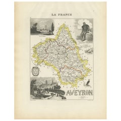
Map of Aveyron France with Rodez, Millau and Wine Routes, 19th Century
Map of Aveyron France with Rodez, Millau and Wine Routes, 19th Century
Description:
This detailed and decorative 19th-century map of Aveyron, a department in southern France, was dr...
Categoría
Antiguo, Mediados del siglo XIX, Francés, Mapas
Materiales
Papel
Map of Ain France with Vineyards of Bugey and Notable Portraits, c.1850
Map of Ain France with Portraits of Bichat and Joubert by Vuillemin, 19th c
This highly decorative 19th-century map of the French department of Ain is taken from the celebrated Nouv...
Categoría
Antiguo, Mediados del siglo XIX, Francés, Mapas
Materiales
Papel

También te puede gustar
Aube, Francia. Mapa antiguo de un departamento francés, 1856
Por Victor Levasseur
Dept. de L'Aube", grabado en acero con contorno original coloreado a mano, 1856, del "Atlas National Illustre" de Levasseur.
Esta zona de Francia es conocida por su producción de C...
Categoría
siglo XIX, Naturalista, Impresiones de paisajes
Materiales
Grabado

Aude, Francia. Mapa antiguo de un departamento francés, 1856
Por Victor Levasseur
"Dept. de L' Aude", grabado en acero con contorno original coloreado a mano., 1856, del "Atlas National Illustre" de Levasseur.
Esta zona de Francia es famosa por su gran variedad ...
Categoría
siglo XIX, Naturalista, Impresiones de paisajes
Materiales
Grabado

Gran mapa de Francia del siglo XIX
Gran mapa de Francia del siglo XIX.
Notable estado, con una agradable pátina desgastada por el tiempo.
Recientemente enmarcado.
Francia Circa 1874.
Categoría
Antiguo, Fines del siglo XIX, Francés, Mapas
Materiales
Lino, Papel

Saona y Loira, Francia. Mapa antiguo de un departamento francés, 1856
Por Victor Levasseur
Dept. de Saone et Loire", grabado en acero con contorno original coloreado a mano, 1856, del Atlas National Illustre de Levasseur.
El departamento francés de Saone et Loire está en...
Categoría
siglo XIX, Naturalista, Impresiones de paisajes
Materiales
Grabado

Indre y Loira, Francia. Mapa antiguo de un departamento francés, 1856
Por Victor Levasseur
"Dept. d'Indre et Loire", grabado en acero con contorno original coloreado a mano., 1856, del "Atlas National Illustre" de Levasseur.
Esta zona es conocida por su producción de Che...
Categoría
siglo XIX, Naturalista, Impresiones de paisajes
Materiales
Grabado

Mapa de Bonne de 1771 de Poitou, Touraine y Anjou, Francia, Ric.a015
1771 Bonne Map de Poitou,
Touraine y Anjou, Francia
Ric.a015
1771 Bonne mapa de Potiou, Touraine y Anjou titulado "Carte des Gouvernements D'Anjou et du Saumurois, de la Tou...
Categoría
Antiguo, siglo XVII, Desconocido, Mapas
Materiales
Papel
