Artículos similares a Map of Basses-Alpes France with Digne and Lavender Region by Vuillemin, c.1850


¿Quieres más imágenes o vídeos?
Solicita imágenes o vídeos adicionales al vendedor
1 de 10
Map of Basses-Alpes France with Digne and Lavender Region by Vuillemin, c.1850
120 €IVA incluido
Acerca del artículo
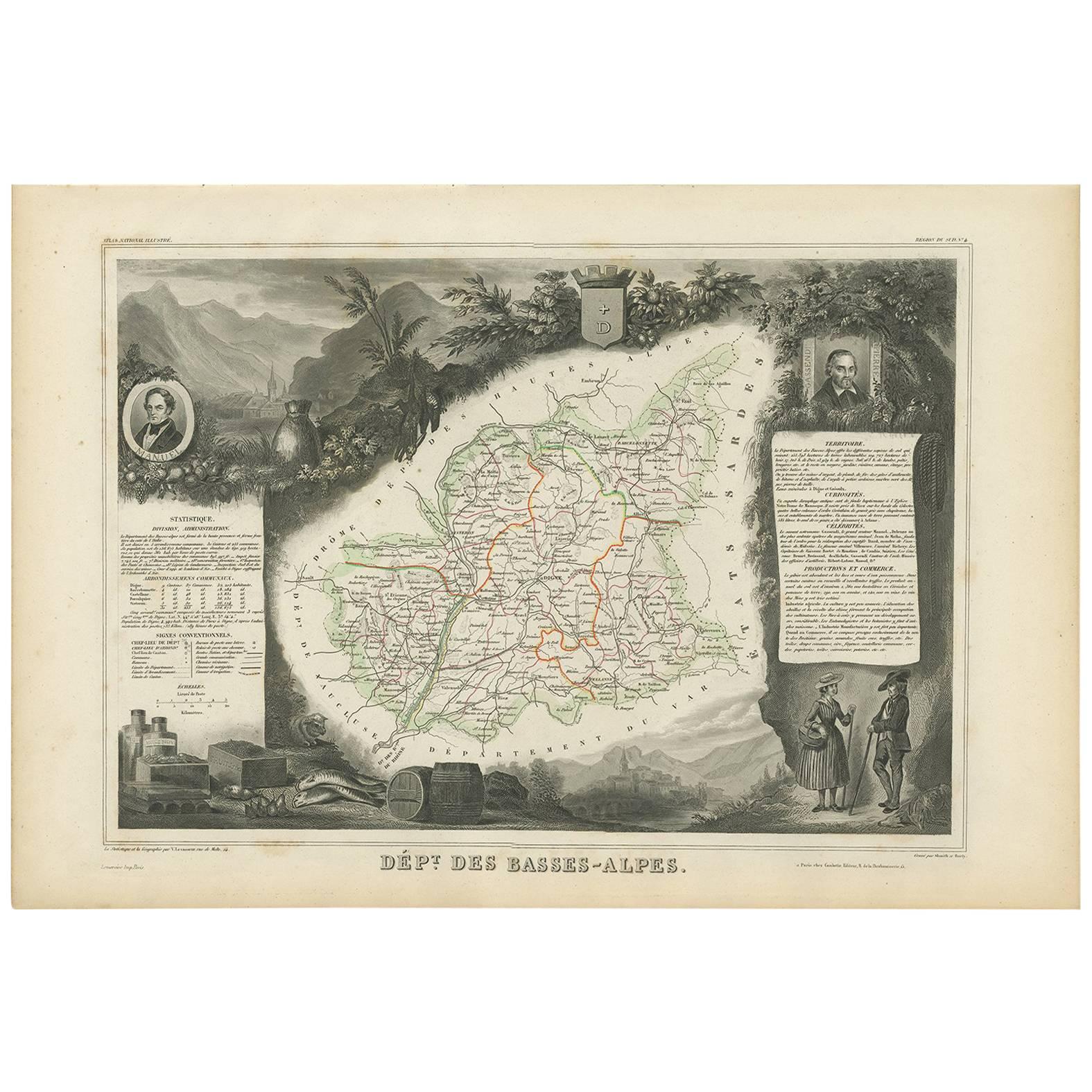
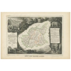
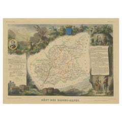
Map of Basses-Alpes France with Digne and Lavender Region by Vuillemin, 19th c
This finely engraved 19th-century map of the Basses-Alpes department of France (known today as Alpes-de-Haute-Provence) is from the renowned Nouvel Atlas Illustré by Alexandre Vuillemin, published by Migeon in Paris. It features delicate hand coloring, regional detail, and elegant vignettes that highlight the cultural and natural identity of the area.
The map outlines the department of Basses-Alpes with clear detail, showcasing towns, rivers, and roads, bordered in soft pastel colors. The mountains, passes, and valleys are rendered with precision, reflecting the department's alpine geography. In the upper left corner, a vignette depicts the town of Digne (now Digne-les-Bains), the administrative center of the department, with the Alps rising in the distance. The bottom left corner features a mountain goat resting on the rocks—an allusion to the region’s wildlife and rugged landscape. To the right, a portrait of Jean-Baptiste Gassendi, philosopher, astronomer, and native of the region, brings historical depth to the composition. Birds flying along the right edge further emphasize the natural richness of the region.
Basses-Alpes is particularly renowned for its stunning lavender fields, which blanket the landscape in purple during summer months. This region, especially the areas around Digne, Forcalquier, and Valensole, is one of the key sources of French lavender, used in perfumes, soaps, and essential oils. In addition to lavender, the region also produces honey, olives, and wines from the Vin de Pays des Alpes-de-Haute-Provence designation.
Alexandre Vuillemin, the cartographer, was a noted 19th-century French mapmaker whose decorative atlases combined geography with culture and art. His publisher, Migeon, specialized in beautifully illustrated educational works. Together, they produced maps that were both informative and visually compelling, popular among scholars and collectors alike.
Condition summary:
Very good condition with slight toning to the margins and a few faint foxing spots, mostly in outer areas. The engraved details are sharp and the original hand-coloring remains clean and attractive.
Framing tips:
This map pairs beautifully with a medium or dark wood frame, or an antique gold moulding to highlight the historic charm. A soft cream or light lavender-toned mat can complement the regional theme. UV-protective glass is recommended to ensure long-term preservation.
- Dimensiones:Altura: 26,1 cm (10,28 in)Anchura: 32,5 cm (12,8 in)Profundidad: 0,2 mm (0,01 in)
- Materiales y técnicas:Papel,Grabado
- Lugar de origen:
- Época:
- Fecha de fabricación:circa 1850
- Estado:Very good condition with slight toning to the margins and a few faint foxing spots, mostly in outer areas. The engraved details are sharp and the original hand-coloring remains clean and attractive.
- Ubicación del vendedor:Langweer, NL
- Número de referencia:Vendedor: BG-13331-41stDibs: LU3054345359142
Sobre el vendedor
5,0
Vendedor reconocido
Estos prestigiosos vendedores son líderes del sector y representan el escalón más alto en cuanto a calidad y diseño de artículos.
Vendedor Platino
Vendedores premium con una calificación de +4,7 y tiempos de respuesta de 24 horas
Establecido en 2009
Vendedor de 1stDibs desde 2017
2609 ventas en 1stDibs
Tiempo de respuesta usual: <1 hora
- EnvíoRecuperando presupuesto…Envío desde: Langweer, Países Bajos
- Política de devolución
Partes de esta página se han traducido automáticamente. 1stDibs no puede garantizar la exactitud de las traducciones. El inglés es el idioma predeterminado de este sitio web.
Garantía de autenticidad
En el improbable caso de que haya algún problema con la autenticidad de un artículo, ponte en contacto con nosotros en un plazo de 1 año para recibir un reembolso total. DetallesGarantía de devolución de dinero
Si tu artículo no es como se describe, sufre daños durante el transporte o no llega, ponte en contacto con nosotros en un plazo de 7 días para recibir un reembolso total. DetallesCancelación dentro de las 24 horas
Tienes un período de gracia de 24 horas para reconsiderar tu compra, sin preguntas.Vendedores profesionales aprobados
Nuestros vendedores de primera clase deben cumplir estrictos estándares de servicio para mantener la integridad de nuestros anuncios.Garantía de igualación de precios
Si encuentras que un vendedor publicó el mismo artículo por un precio menor en otro lado, igualaremos ese precio.Entrega global de confianza
Nuestra red de transporte de primera ofrece opciones de envío especializado en todo el mundo, que incluye envío personalizado.Más de este vendedor
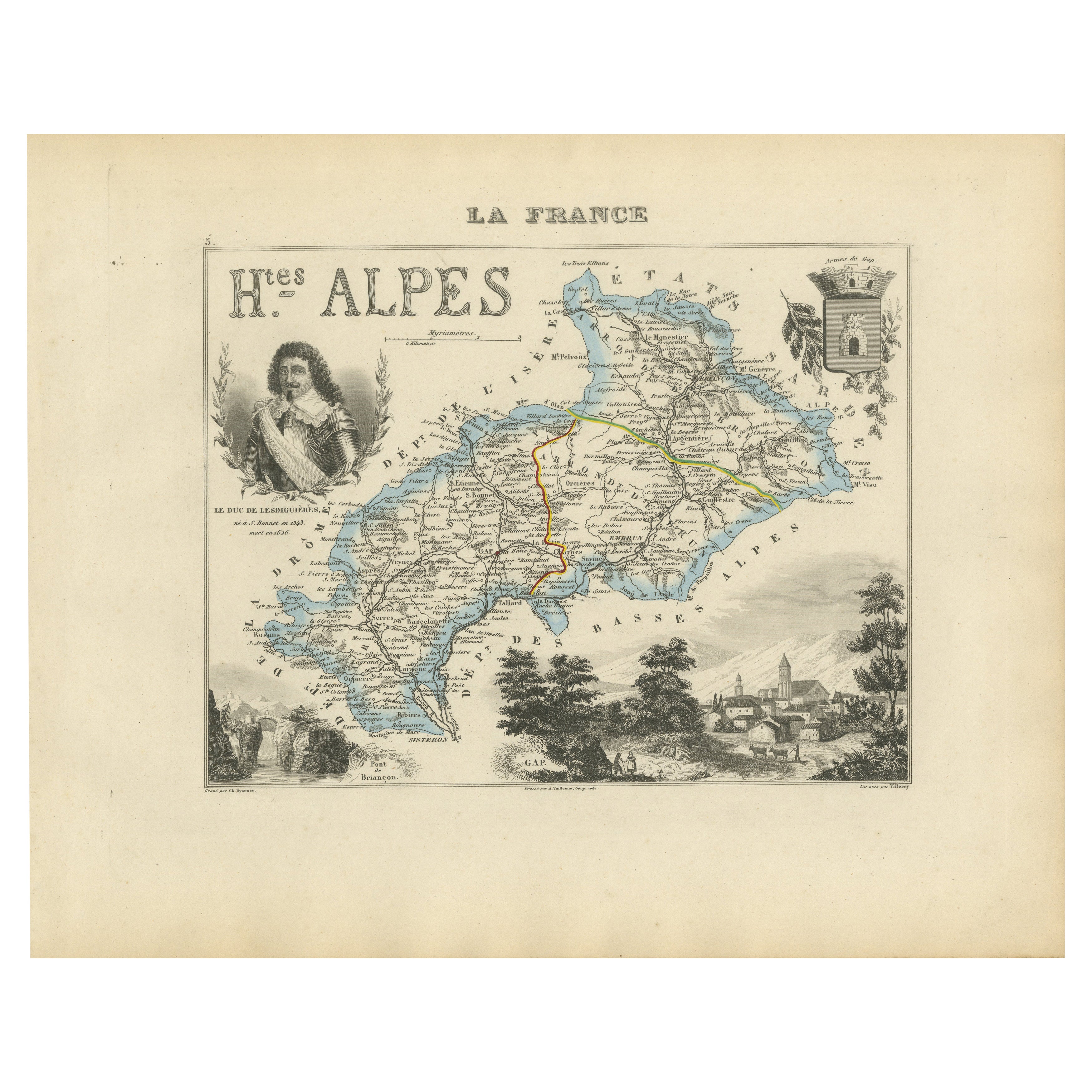
Ver todoMap of Hautes-Alpes France with Gap and Alpine Scenery by Vuillemin, c.1850
Map of Hautes-Alpes France with Gap and Alpine Scenery by Vuillemin
Description:
This elegant 19th-century map of the Hautes-Alpes department in southeastern France was created by A...
Categoría
Antiguo, Mediados del siglo XIX, Francés, Mapas
Materiales
Papel

Map of Ain France with Vineyards of Bugey and Notable Portraits, c.1850
Map of Ain France with Portraits of Bichat and Joubert by Vuillemin, 19th c
This highly decorative 19th-century map of the French department of Ain is taken from the celebrated Nouv...
Categoría
Antiguo, Mediados del siglo XIX, Francés, Mapas
Materiales
Papel

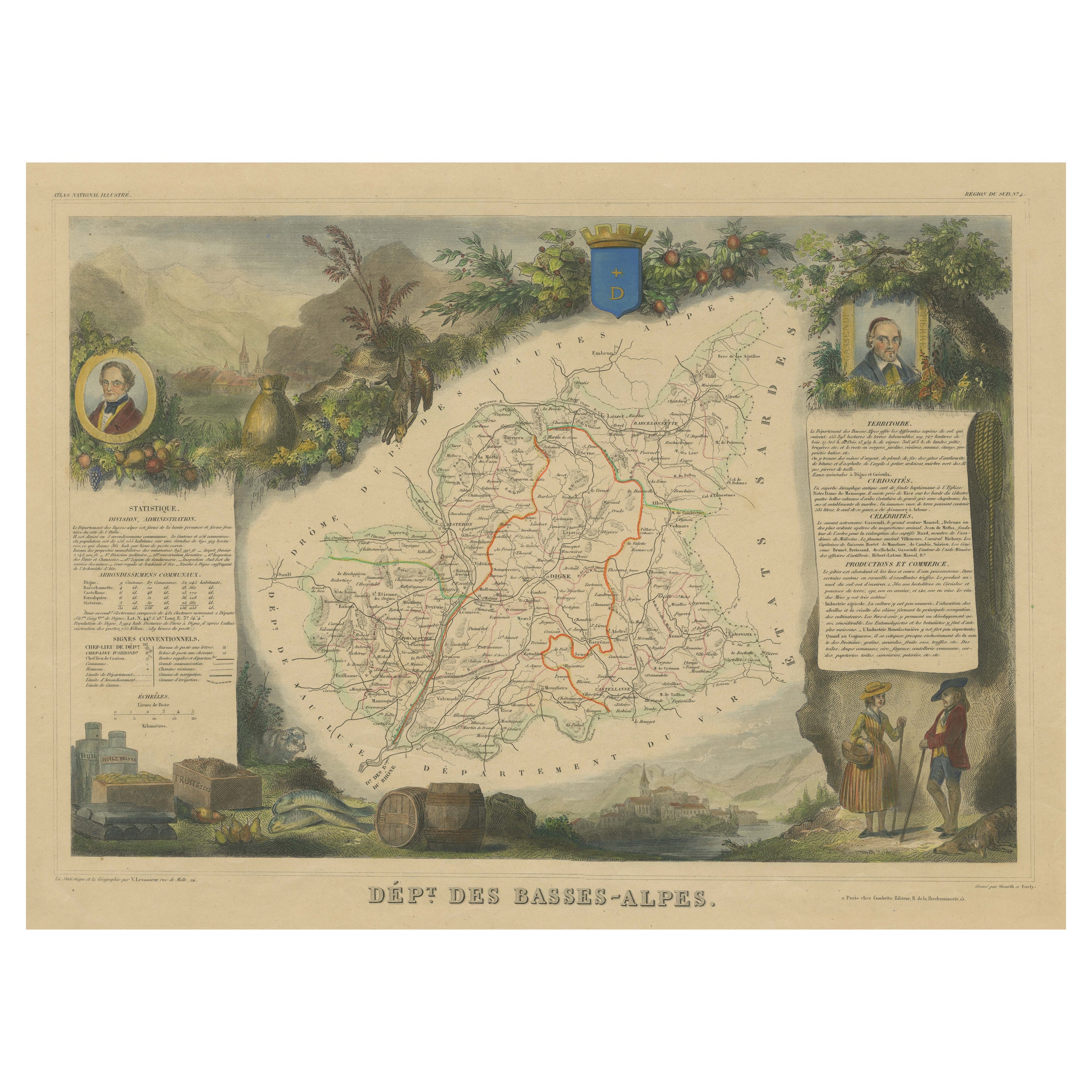
Mapa antiguo de Bajos Alpes "Francia" por V. Levasseur, 1854
Por Victor Levasseur
Mapa antiguo titulado "Dépt. des Basses-Alpes". Mapa del departamento francés de Bajos Alpes, Francia. El conjunto está rodeado de elaborados grabados decorativos concebidos para ilu...
Categoría
Antiguo, Mediados del siglo XIX, Mapas
Materiales
Papel
160 € Precio de venta
Descuento del 20 %
Map of Allier France with Saint-Pourçain Wine Region by Vuillemin, 19th c
Map of Allier France with Saint-Pourçain Wine Region by Vuillemin, 19th c
This decorative 19th-century map of Allier, a central department of France, comes from the celebrated Nouve...
Categoría
Antiguo, Mediados del siglo XIX, Francés, Mapas
Materiales
Papel

Mapa Antiguo Coloreado a Mano del Departamento de Bajos Alpes, Francia
Por Victor Levasseur
Mapa antiguo titulado "Dépt. de l'Aube". Mapa del departamento francés de Bajos Alpes, Francia. El conjunto está rodeado de elaborados grabados decorativos concebidos para ilustrar t...
Categoría
Antiguo, Mediados del siglo XIX, Mapas
Materiales
Papel
272 € Precio de venta
Descuento del 20 %
Map of Côtes-du-Nord France with Saint-Brieuc and Brittany Coastline, c.1850
Map of Côtes-du-Nord France with Saint-Brieuc and Brittany Coastline, 19th c
Description:
This elegant 19th-century map of Côtes-du-Nord, the historic name for what is now known as ...
Categoría
Antiguo, Mediados del siglo XIX, Francés, Mapas
Materiales
Papel

También te puede gustar
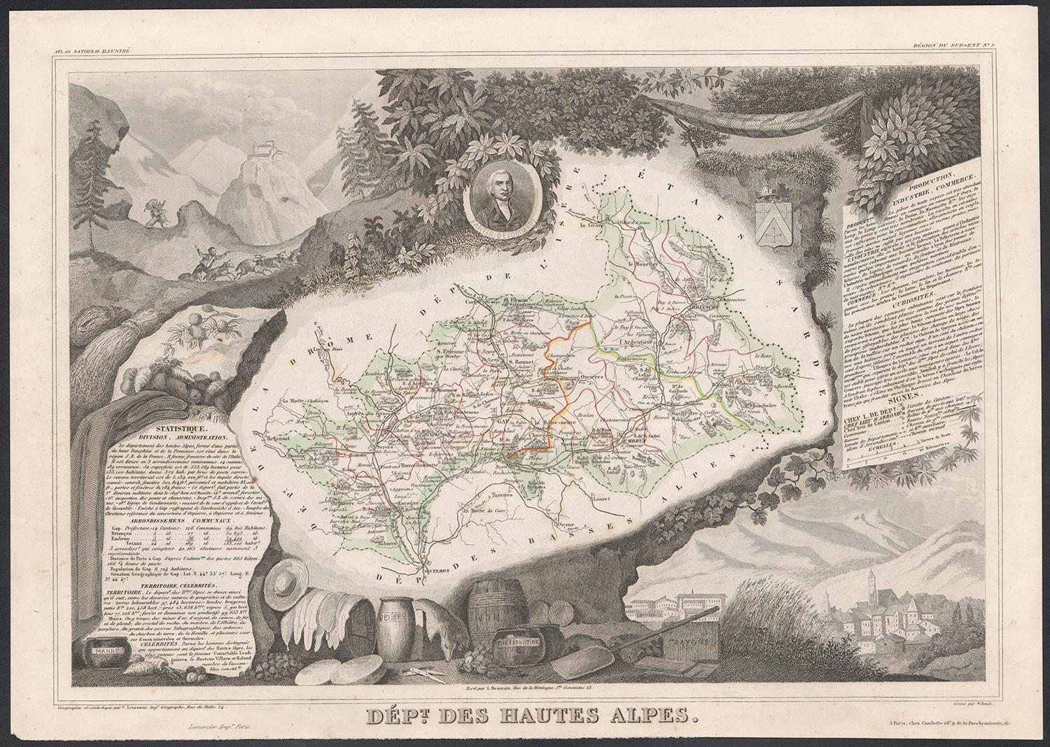
Altos Alpes, Francia. Mapa antiguo de un departamento francés, 1856
Por Victor Levasseur
Dept. des Hautes Alpes", grabado en acero con contorno original coloreado a mano, 1856, del "Atlas National Illustre" de Levasseur.
Esta zona de Francia es conocida por su producci...
Categoría
siglo XIX, Naturalista, Impresiones de paisajes
Materiales
Grabado

Altos Pirineos, Francia. Mapa antiguo de un departamento francés, 1856
Por Victor Levasseur
Dept. des Hautes Pyrenees", grabado en acero con contorno original coloreado a mano., 1856, del Atlas National Illustre de Levasseur.
En esta zona se encuentra la región vinícola d...
Categoría
siglo XIX, Naturalista, Impresiones de paisajes
Materiales
Grabado
Pirineos Orientales, Francia. Mapa antiguo de un departamento francés, 1856
Por Victor Levasseur
Dept. des Pyrenees Orientales", grabado en acero con contorno original coloreado a mano, 1856, del "Atlas National Illustre" de Levasseur.
Esta zona es una conocida región producto...
Categoría
siglo XIX, Naturalista, Impresiones de paisajes
Materiales
Grabado

Mapa de los Altos Pirineos - Litografía original - Siglo XIX
El Mapa de los Altos Pirineos es una litografía original realizada por un grabador anónimo del siglo XIX.
Impreso en serie de "France Pittoresque" en la parte superior central.
El ...
Categoría
siglo XIX, Moderno, Impresiones figurativas
Materiales
Papel, Litografía

Mapa antiguo en acuarela de 1856 del Departamento de Altos Alpes de Levasseur's
Nos complace poner a la venta este impresionante mapa de los Alpes austriacos realizado a mano y acuarelado en 1856, titulado Dept Des Hautes Alpes, extraído del Atlas National Illus...
Categoría
Antiguo, Década de 1850, Francés, Victoriano temprano, Mapas
Materiales
Papel

617 € Precio de venta
Descuento del 30 %
Lozere, Francia. Mapa antiguo de un departamento francés, 1856
Por Victor Levasseur
Dept. de La Lozere", grabado en acero con contorno original coloreado a mano, 1856, del "Atlas National Illustre" de Levasseur.
Esta remota zona montañosa de Languedoc es rural, po...
Categoría
siglo XIX, Naturalista, Impresiones de paisajes
Materiales
Grabado
