Artículos similares a Map of Côtes-du-Nord France with Saint-Brieuc and Brittany Coastline, c.1850


¿Quieres más imágenes o vídeos?
Solicita imágenes o vídeos adicionales al vendedor
1 de 10
Map of Côtes-du-Nord France with Saint-Brieuc and Brittany Coastline, c.1850
120 €IVA incluido
Acerca del artículo
Map of Côtes-du-Nord France with Saint-Brieuc and Brittany Coastline, 19th c
Description:
This elegant 19th-century map of Côtes-du-Nord, the historic name for what is now known as Côtes-d’Armor in Brittany, was created by Alexandre Vuillemin and published by Migeon in Paris for the *Nouvel Atlas Illustré*. Blending precise cartographic detail with finely engraved embellishments, the map presents the coastal and inland features of this northwestern French department.
The map outlines Côtes-du-Nord in soft pink hand-coloring and carefully labels towns, rivers, and roadways. Saint-Brieuc, the prefecture, is centrally located along the northern coast, while other important towns such as Dinan, Lannion, Guingamp, and Loudéac are also marked. The geography reflects the area’s rugged coastlines, with peninsulas, small bays, and offshore islands rendered with care. The northern boundary is bordered by the English Channel, historically vital for trade and maritime activity.
A charming vignette at the top right depicts the Breton countryside with a wayside cross and a rural village in the distance—an homage to the region’s deep Catholic and pastoral traditions. In the lower right corner is a portrait of Jean-Marie de Lamennais, a prominent 19th-century priest and educational reformer from the region. The coat of arms, accompanied by a decorative banner, appears at bottom left, adding a heraldic touch.
Côtes-du-Nord, now Côtes-d’Armor, is part of historic Brittany and known for its strong cultural identity, Celtic heritage, and rich agricultural landscape. While not famous for wine, the region is renowned for apple orchards and traditional Breton cider production. It is also known for dairy, salt production, fishing, and religious architecture, including numerous chapels and calvaries.
This map captures the essence of 19th-century Brittany—spiritual, rural, and maritime—offering a decorative yet informative view of the region. It is a compelling piece for collectors of antique maps or those interested in the history and culture of northwestern France.
Condition summary:
Very good condition with slight toning to the edges and light foxing in the margins. The engraving is crisp and the hand coloring remains clear and vibrant.
Framing tips:
A rustic wood or black frame complements the coastal and cultural theme. A cream or pale grey mat will enhance the visual contrast with the soft pink border and engraved details. Use UV-protective glass for long-term preservation.
- Dimensiones:Altura: 26,1 cm (10,28 in)Anchura: 32,5 cm (12,8 in)Profundidad: 0,2 mm (0,01 in)
- Materiales y técnicas:Papel,Grabado
- Lugar de origen:
- Época:
- Fecha de fabricación:circa 1850
- Estado:Very good condition with slight toning to the edges and light foxing in the margins. The engraving is crisp and the hand coloring remains clear and vibrant.
- Ubicación del vendedor:Langweer, NL
- Número de referencia:Vendedor: BG-13331-211stDibs: LU3054345363662
Sobre el vendedor
5,0
Vendedor reconocido
Estos prestigiosos vendedores son líderes del sector y representan el escalón más alto en cuanto a calidad y diseño de artículos.
Vendedor Platino
Vendedores premium con una calificación de +4,7 y tiempos de respuesta de 24 horas
Establecido en 2009
Vendedor de 1stDibs desde 2017
2655 ventas en 1stDibs
Tiempo de respuesta usual: <1 hora
- EnvíoRecuperando presupuesto…Envío desde: Langweer, Países Bajos
- Política de devolución
Partes de esta página se han traducido automáticamente. 1stDibs no puede garantizar la exactitud de las traducciones. El inglés es el idioma predeterminado de este sitio web.
Garantía de autenticidad
En el improbable caso de que haya algún problema con la autenticidad de un artículo, ponte en contacto con nosotros en un plazo de 1 año para recibir un reembolso total. DetallesGarantía de devolución de dinero
Si tu artículo no es como se describe, sufre daños durante el transporte o no llega, ponte en contacto con nosotros en un plazo de 7 días para recibir un reembolso total. DetallesCancelación dentro de las 24 horas
Tienes un período de gracia de 24 horas para reconsiderar tu compra, sin preguntas.Vendedores profesionales aprobados
Nuestros vendedores de primera clase deben cumplir estrictos estándares de servicio para mantener la integridad de nuestros anuncios.Garantía de igualación de precios
Si encuentras que un vendedor publicó el mismo artículo por un precio menor en otro lado, igualaremos ese precio.Entrega global de confianza
Nuestra red de transporte de primera ofrece opciones de envío especializado en todo el mundo, que incluye envío personalizado.Más de este vendedor
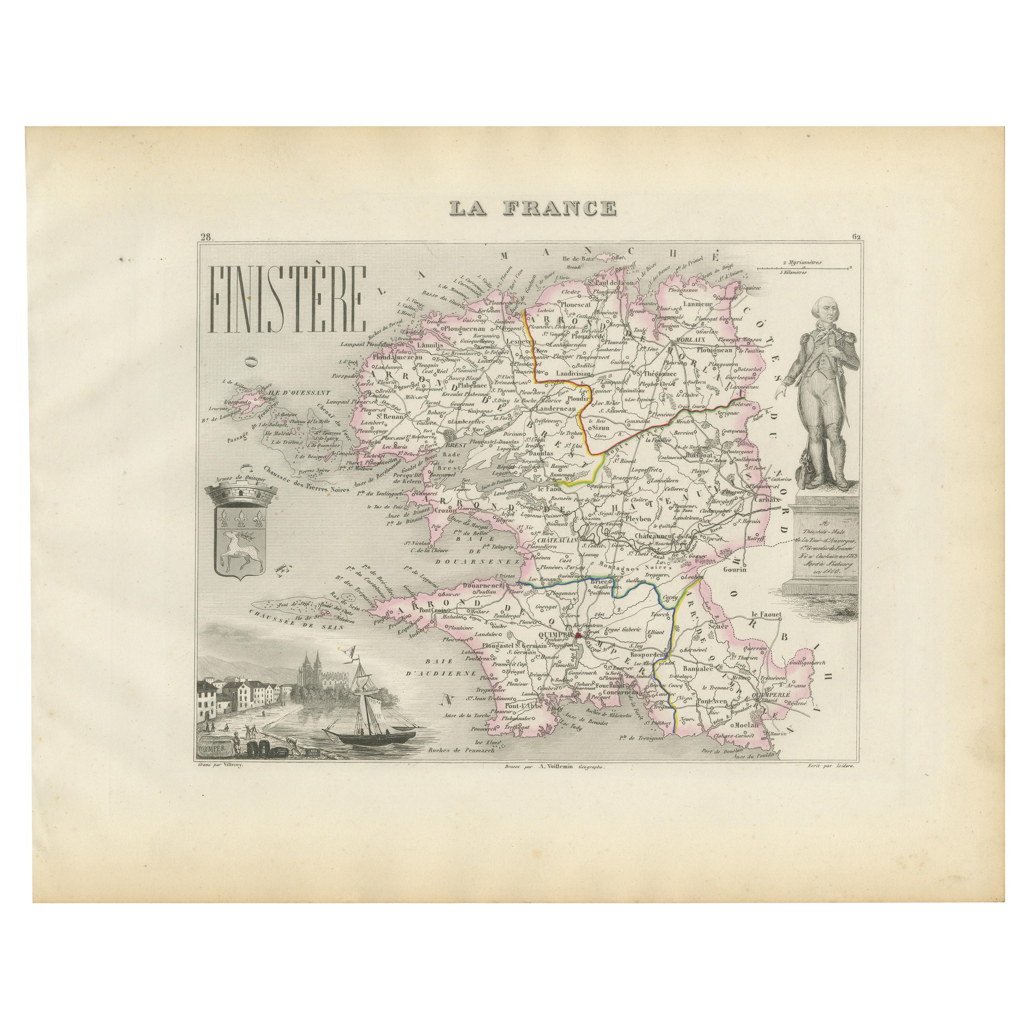
Ver todoMap of Finistère France with Brest, Quimper and Brittany Coastline, 19th Century
Map of Finistère France with Brest, Quimper and Brittany Coastline, 19th Century
Description:
This richly engraved 19th-century map of Finistère, the westernmost department of mainl...
Categoría
Antiguo, Mediados del siglo XIX, Francés, Mapas
Materiales
Papel
Antique French Map of Ille-et-Vilaine Region with Rennes, Saint-Malo, 1800s
Mapa antiguo de Ille-et-Vilaine, Francia, por Vuillemin, siglo XIX
Este decorativo mapa antiguo presenta el departamento francés de Ille-et-Vilaine, situado en la región de Bretaña,...
Categoría
Antiguo, Mediados del siglo XIX, Francés, Mapas
Materiales
Papel

Map of Allier France with Saint-Pourçain Wine Region by Vuillemin, 19th c
Map of Allier France with Saint-Pourçain Wine Region by Vuillemin, 19th c
This decorative 19th-century map of Allier, a central department of France, comes from the celebrated Nouve...
Categoría
Antiguo, Mediados del siglo XIX, Francés, Mapas
Materiales
Papel

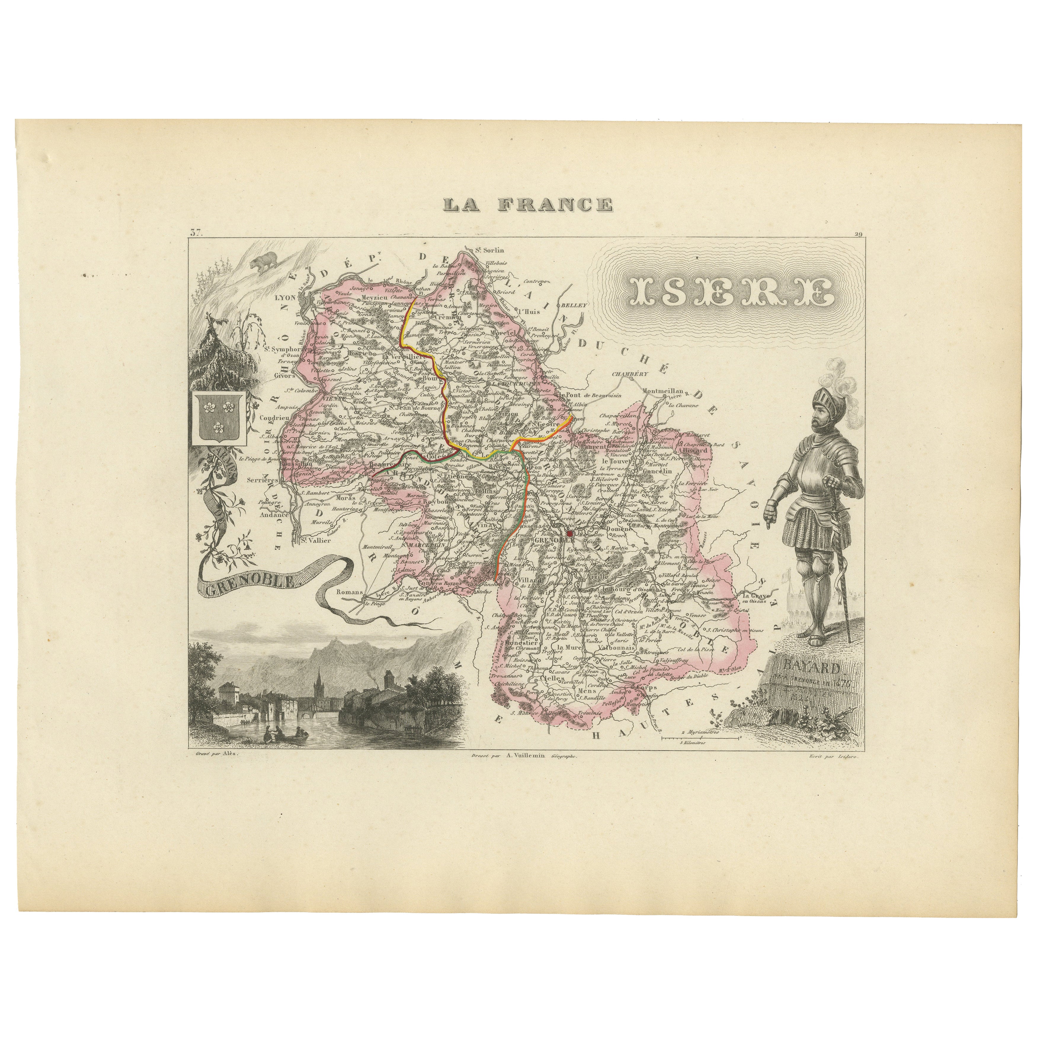
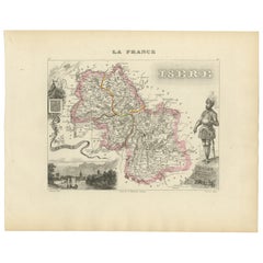
Antique French Map of Isère Region with Grenoble, Vienne, Dauphiné, 1800s
Mapa antiguo de Isère, Francia, por Vuillemin, siglo XIX
Este decorativo mapa del siglo XIX presenta el departamento de Isère, en el sureste de Francia, grabado por Alexandre Vuille...
Categoría
Antiguo, Mediados del siglo XIX, Francés, Mapas
Materiales
Papel
Map of Côte-d'Or France with Dijon and Burgundy Wine Region, 19th Century
Map of Côte-d'Or France with Dijon and Burgundy Wine Region, 19th Century
Description:
This beautifully engraved 19th-century map of Côte-d'Or, located in the historic region of Bur...
Categoría
Antiguo, Mediados del siglo XIX, Francés, Mapas
Materiales
Papel

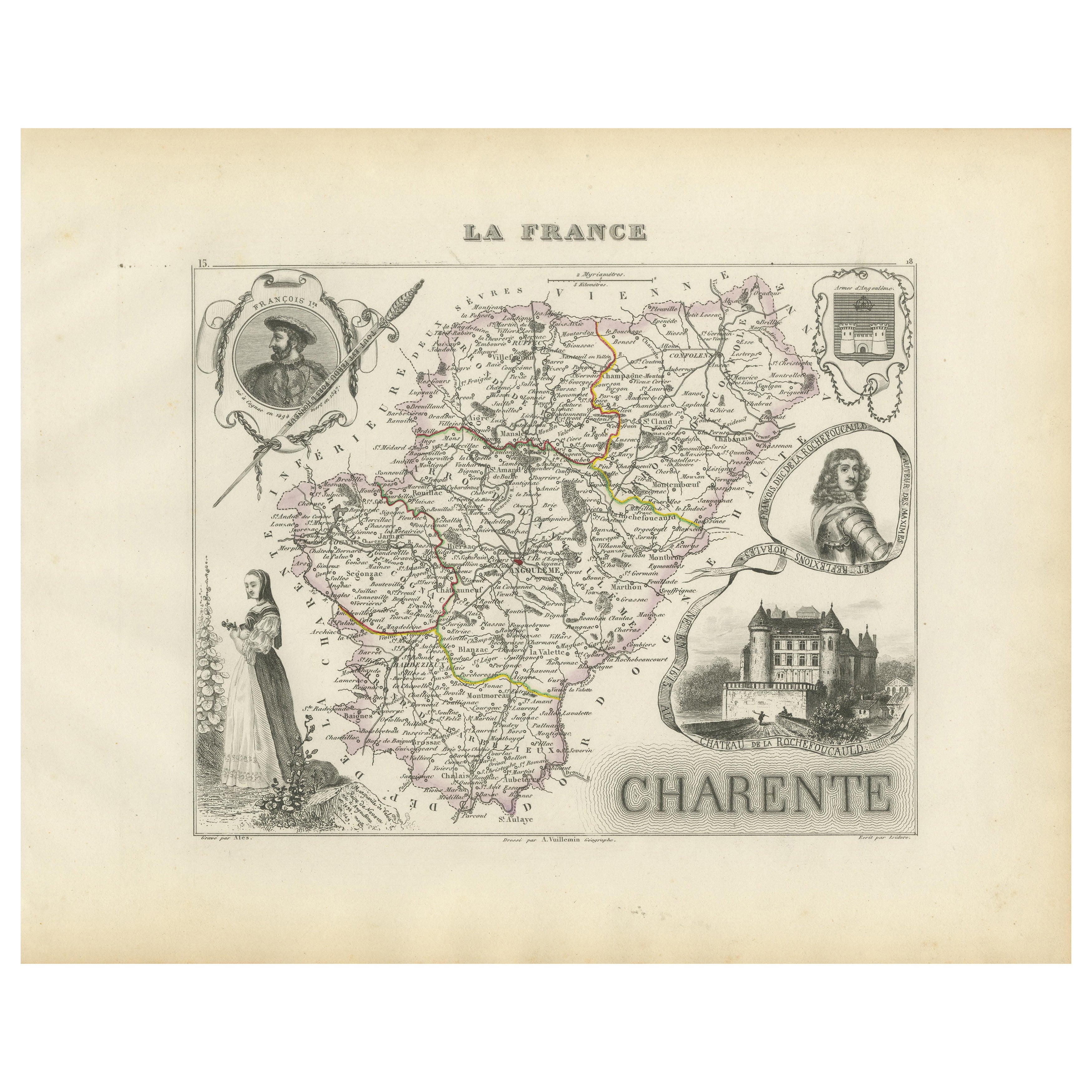
Map of Charente France with Cognac Region and Château de La Rochefoucauld, 1850
Map of Charente France with Cognac Region and Château de La Rochefoucauld, 19th c
Description:
This richly illustrated 19th-century map of the Charente department in southwestern Fr...
Categoría
Antiguo, Mediados del siglo XIX, Francés, Mapas
Materiales
Papel

También te puede gustar
Indre y Loira, Francia. Mapa antiguo de un departamento francés, 1856
Por Victor Levasseur
"Dept. d'Indre et Loire", grabado en acero con contorno original coloreado a mano., 1856, del "Atlas National Illustre" de Levasseur.
Esta zona es conocida por su producción de Che...
Categoría
siglo XIX, Naturalista, Impresiones de paisajes
Materiales
Grabado

Gran mapa de Francia del siglo XIX
Gran mapa de Francia del siglo XIX.
Notable estado, con una agradable pátina desgastada por el tiempo.
Recientemente enmarcado.
Francia Circa 1874.
Categoría
Antiguo, Fines del siglo XIX, Francés, Mapas
Materiales
Lino, Papel

Lozere, Francia. Mapa antiguo de un departamento francés, 1856
Por Victor Levasseur
Dept. de La Lozere", grabado en acero con contorno original coloreado a mano, 1856, del "Atlas National Illustre" de Levasseur.
Esta remota zona montañosa de Languedoc es rural, po...
Categoría
siglo XIX, Naturalista, Impresiones de paisajes
Materiales
Grabado

Var, Francia. Mapa antiguo de un departamento francés, 1856
Por Victor Levasseur
Dept. du Var", grabado en acero con contorno original coloreado a mano, 1856, del Atlas National Illustre de Levasseur.
Var abarca el corazón de la Costa Azul, e incluye las ciudad...
Categoría
siglo XIX, Naturalista, Impresiones de paisajes
Materiales
Grabado

Saona y Loira, Francia. Mapa antiguo de un departamento francés, 1856
Por Victor Levasseur
Dept. de Saone et Loire", grabado en acero con contorno original coloreado a mano, 1856, del Atlas National Illustre de Levasseur.
El departamento francés de Saone et Loire está en...
Categoría
siglo XIX, Naturalista, Impresiones de paisajes
Materiales
Grabado

Mapa de Bonne de 1771 de Poitou, Touraine y Anjou, Francia, Ric.a015
1771 Bonne Map de Poitou,
Touraine y Anjou, Francia
Ric.a015
1771 Bonne mapa de Potiou, Touraine y Anjou titulado "Carte des Gouvernements D'Anjou et du Saumurois, de la Tou...
Categoría
Antiguo, siglo XVII, Desconocido, Mapas
Materiales
Papel
