Artículos similares a Map of Calvados France with Caen and Cider-Brandy Region, 19th Century


¿Quieres más imágenes o vídeos?
Solicita imágenes o vídeos adicionales al vendedor
1 de 10
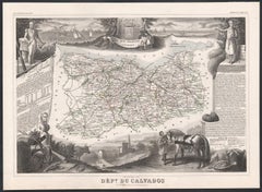
Map of Calvados France with Caen and Cider-Brandy Region, 19th Century
120 €IVA incluido
Acerca del artículo
Map of Calvados France with Caen and Cider-Brandy Region, 19th Century
Description:
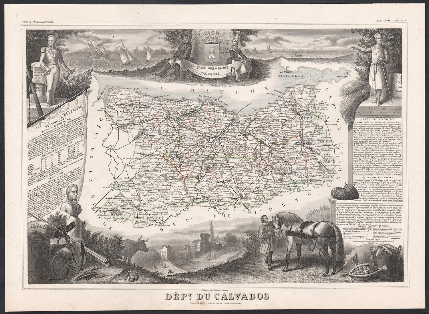
This finely engraved 19th-century map of the Calvados department in Normandy, northwestern France, comes from the *Nouvel Atlas Illustré* published in Paris by Migeon. The map was drawn by Alexandre Vuillemin and features a rich combination of precise geography and elegant embellishments, reflecting the historical and agricultural importance of this coastal region.
The map outlines Calvados in soft pink hand-coloring, highlighting towns, rivers, and roads, with the English Channel (La Manche) bordering the north. Caen, the department's capital and a cultural center since medieval times, is prominently positioned. The cartographic detailing includes the famed Norman countryside and coast, which played a vital role in French history and later in World War II.
In the lower left is a portrait of Dumont d’Urville, the explorer and naval officer born in Condé-sur-Noireau in Calvados. He is shown with nautical instruments, referencing his significant contributions to French exploration and science. In the lower right is a finely rendered view of the city of Caen, with its imposing Gothic architecture, likely representing the Church of Saint-Pierre or the Abbey of Saint-Étienne founded by William the Conqueror.
Calvados is perhaps best known for its namesake apple brandy, produced in the rolling orchards that stretch across the region. The department lies at the heart of the Calvados AOC, where cider apples are grown and distilled into one of France’s most iconic spirits. Alongside Calvados brandy, the region also produces fine cider, pommeau, and a range of cheeses, most notably Pont-l'Évêque and Livarot. These agricultural products have earned Calvados a reputation for rustic elegance and culinary depth.
This map captures the spirit of Normandy's maritime heritage, its agricultural landscape, and its intellectual legacy, making it ideal for collectors of historic French regions or food and wine enthusiasts.
Condition summary:
Very good condition with some light toning and minor foxing to the margins. The engraved detail is crisp, and the original hand coloring is well preserved.
Framing tips:
A rustic oak or walnut frame would match the map’s Norman character. A soft ivory or light grey mat will highlight the pink border color and the engraved vignette of Caen. Use museum-quality glass to protect and enhance the print for display.
- Dimensiones:Altura: 26,1 cm (10,28 in)Anchura: 32,5 cm (12,8 in)Profundidad: 0,2 mm (0,01 in)
- Materiales y técnicas:Papel,Grabado
- Lugar de origen:
- Época:
- Fecha de fabricación:circa 1850
- Estado:Very good condition with some light toning and minor foxing to the margins. The engraved detail is crisp, and the original hand coloring is well preserved.
- Ubicación del vendedor:Langweer, NL
- Número de referencia:Vendedor: BG-13331-131stDibs: LU3054345359802
Sobre el vendedor
5,0
Vendedor reconocido
Estos prestigiosos vendedores son líderes del sector y representan el escalón más alto en cuanto a calidad y diseño de artículos.
Vendedor Platino
Vendedores premium con una calificación de +4,7 y tiempos de respuesta de 24 horas
Establecido en 2009
Vendedor de 1stDibs desde 2017
2620 ventas en 1stDibs
Tiempo de respuesta usual: <1 hora
- EnvíoRecuperando presupuesto…Envío desde: Langweer, Países Bajos
- Política de devolución
Partes de esta página se han traducido automáticamente. 1stDibs no puede garantizar la exactitud de las traducciones. El inglés es el idioma predeterminado de este sitio web.
Garantía de autenticidad
En el improbable caso de que haya algún problema con la autenticidad de un artículo, ponte en contacto con nosotros en un plazo de 1 año para recibir un reembolso total. DetallesGarantía de devolución de dinero
Si tu artículo no es como se describe, sufre daños durante el transporte o no llega, ponte en contacto con nosotros en un plazo de 7 días para recibir un reembolso total. DetallesCancelación dentro de las 24 horas
Tienes un período de gracia de 24 horas para reconsiderar tu compra, sin preguntas.Vendedores profesionales aprobados
Nuestros vendedores de primera clase deben cumplir estrictos estándares de servicio para mantener la integridad de nuestros anuncios.Garantía de igualación de precios
Si encuentras que un vendedor publicó el mismo artículo por un precio menor en otro lado, igualaremos ese precio.Entrega global de confianza
Nuestra red de transporte de primera ofrece opciones de envío especializado en todo el mundo, que incluye envío personalizado.Más de este vendedor
Ver todoMap of Allier France with Saint-Pourçain Wine Region by Vuillemin, 19th c
Map of Allier France with Saint-Pourçain Wine Region by Vuillemin, 19th c
This decorative 19th-century map of Allier, a central department of France, comes from the celebrated Nouve...
Categoría
Antiguo, Mediados del siglo XIX, Francés, Mapas
Materiales
Papel

Map of Côtes-du-Nord France with Saint-Brieuc and Brittany Coastline, c.1850
Map of Côtes-du-Nord France with Saint-Brieuc and Brittany Coastline, 19th c
Description:
This elegant 19th-century map of Côtes-du-Nord, the historic name for what is now known as ...
Categoría
Antiguo, Mediados del siglo XIX, Francés, Mapas
Materiales
Papel

Map of Côte-d'Or France with Dijon and Burgundy Wine Region, 19th Century
Map of Côte-d'Or France with Dijon and Burgundy Wine Region, 19th Century
Description:
This beautifully engraved 19th-century map of Côte-d'Or, located in the historic region of Bur...
Categoría
Antiguo, Mediados del siglo XIX, Francés, Mapas
Materiales
Papel

Mapa antiguo de Calvados 'Francia' por V. Levasseur, 1854
Por Victor Levasseur
Mapa antiguo titulado "Dépt. du Calvados". Mapa del departamento francés de Calvados, Francia. Esta zona de Francia es conocida por su producción de Calvados, el aguardiente de manza...
Categoría
Antiguo, Mediados del siglo XIX, Mapas
Materiales
Papel
160 € Precio de venta
Descuento del 20 %
Map of Aude France with Carcassonne and Languedoc Vineyards, 19th Century
Map of Aude France with Carcassonne and Languedoc Vineyards, 19th Century
Description:
This elegant 19th-century map of Aude, a department in southern France along the Mediterranean...
Categoría
Antiguo, Mediados del siglo XIX, Francés, Mapas
Materiales
Papel

Mapa antiguo de Calais 'Francia' por V. Levasseur, 1854
Por Victor Levasseur
Mapa antiguo titulado "Dépt. du Pas de Calais". Mapa del departamento francés de Calais, Francia. Esta zona es conocida por producir el Maroilles, un queso blando elaborado con leche...
Categoría
Antiguo, Mediados del siglo XIX, Mapas
Materiales
Papel
144 € Precio de venta
Descuento del 20 %
También te puede gustar
Calvados, Francia. Mapa antiguo de un departamento francés, 1856
Por Victor Levasseur
"Dept. du Calvados", grabado en acero con contorno original coloreado a mano., 1856, del "Atlas National Illustre" de Levasseur.
Esta zona de Francia es conocida por su producción ...
Categoría
siglo XIX, Naturalista, Impresiones de paisajes
Materiales
Grabado
Gran mapa de Francia del siglo XIX
Gran mapa de Francia del siglo XIX.
Notable estado, con una agradable pátina desgastada por el tiempo.
Recientemente enmarcado.
Francia Circa 1874.
Categoría
Antiguo, Fines del siglo XIX, Francés, Mapas
Materiales
Lino, Papel

Circa 1950 original map poster of Calvados, designed by André Lesot - Normandy
Este póster original del mapa de Calvados de 1950, diseñado por André Lesot, es una representación bellamente detallada de esta región histórica de Normandía (Francia). Producido por...
Categoría
Década de 1950, Impresiones y múltiplos
Materiales
Litografía, Papel, Lino
Aude, Francia. Mapa antiguo de un departamento francés, 1856
Por Victor Levasseur
"Dept. de L' Aude", grabado en acero con contorno original coloreado a mano., 1856, del "Atlas National Illustre" de Levasseur.
Esta zona de Francia es famosa por su gran variedad ...
Categoría
siglo XIX, Naturalista, Impresiones de paisajes
Materiales
Grabado

Var, Francia. Mapa antiguo de un departamento francés, 1856
Por Victor Levasseur
Dept. du Var", grabado en acero con contorno original coloreado a mano, 1856, del Atlas National Illustre de Levasseur.
Var abarca el corazón de la Costa Azul, e incluye las ciudad...
Categoría
siglo XIX, Naturalista, Impresiones de paisajes
Materiales
Grabado

Francia, Parte Norte. Mapa antiguo Century Atlas
El Atlas del Siglo. Francia, Parte Norte".
Mapa antiguo original, 1903.
Mapas en recuadro de "Francia en provincias" y "París y alrededores".
Pliegue central como se emitió. Nombre...
Categoría
principios del siglo XX, Victoriano, Más impresiones
Materiales
Litografía
