Artículos similares a Map of Dordogne France with Périgueux and Château de Jumilhac, 19th Century


¿Quieres más imágenes o vídeos?
Solicita imágenes o vídeos adicionales al vendedor
1 de 10
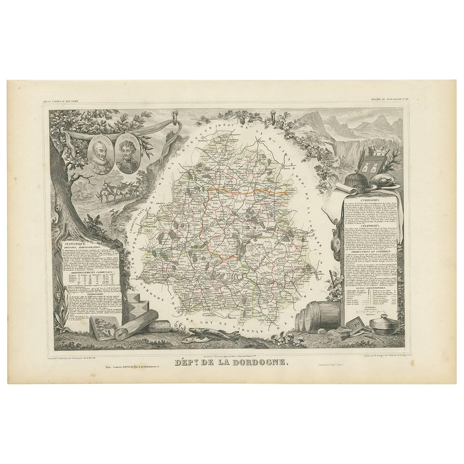
Map of Dordogne France with Périgueux and Château de Jumilhac, 19th Century
140 €IVA incluido
Acerca del artículo
Map of Dordogne France with Périgueux and Château de Jumilhac, 19th Century
Description:
This richly detailed 19th-century map of the Dordogne department in southwestern France was drawn by Alexandre Vuillemin and published by Migeon in Paris for the *Nouvel Atlas Illustré*. The map masterfully combines cartographic precision with elegant engravings that highlight the historical and cultural significance of this beloved region of Aquitaine.
The map outlines Dordogne in soft green hand-coloring, with towns, rivers, and roadways finely engraved. The departmental capital, Périgueux, is centrally located and clearly labeled, along with other important towns such as Bergerac, Sarlat, Nontron, and Ribérac. The rolling hills, intersecting river valleys, and dense forests of the Périgord region are suggested through detailed topographical lines.
At the lower left is a charming vignette of Périgueux with its cathedral dome rising above a riverside village scene. To the lower right, the Château de Jumilhac appears perched on a slope, representing the region’s long architectural history and noble estates. The upper left features a portrait of François Fénelon, the theologian and writer born in Périgord in the 17th century. His inclusion reflects the department’s intellectual heritage. The heraldic crest of Dordogne also appears in the upper right.
Dordogne is famous for its culinary and cultural wealth, particularly its foie gras, truffles, walnuts, and wines. Bergerac, located in the southwestern part of the department, is a key wine-producing area within the Bergerac AOC, known for its red, white, and rosé wines. The vineyards here produce wines from Bordeaux varietals such as Merlot, Cabernet Sauvignon, and Sauvignon Blanc, with increasingly refined expressions gaining international recognition. The region is also steeped in prehistoric significance, home to the Lascaux caves and numerous archaeological sites.
This map is a decorative and historical homage to Dordogne’s blend of gastronomy, viticulture, literature, and rural charm. It is a superb piece for collectors with interests in French culture, food, wine, and history.
Condition summary:
Very good condition with light toning and a few small foxing marks, mainly around the margins. The engraving remains crisp and the hand coloring is well preserved.
Framing tips:
Pair this map with a warm walnut or golden oak frame to reflect the earthy tones of Dordogne. A cream or soft green mat will complement the coloring and highlight the detailed vignettes. Use UV-protective glass for long-term display and preservation.
- Dimensiones:Altura: 32,5 cm (12,8 in)Anchura: 26,1 cm (10,28 in)Profundidad: 0,2 mm (0,01 in)
- Materiales y técnicas:Papel,Grabado
- Lugar de origen:
- Época:
- Fecha de fabricación:circa 1850
- Estado:Very good condition with light toning and a few small foxing marks, mainly around the margins. The engraving remains crisp and the hand coloring is well preserved.
- Ubicación del vendedor:Langweer, NL
- Número de referencia:Vendedor: BG-13331-231stDibs: LU3054345363672
Sobre el vendedor
5,0
Vendedor reconocido
Estos prestigiosos vendedores son líderes del sector y representan el escalón más alto en cuanto a calidad y diseño de artículos.
Vendedor Platino
Vendedores premium con una calificación de +4,7 y tiempos de respuesta de 24 horas
Establecido en 2009
Vendedor de 1stDibs desde 2017
2655 ventas en 1stDibs
Tiempo de respuesta usual: <1 hora
- EnvíoRecuperando presupuesto…Envío desde: Langweer, Países Bajos
- Política de devolución
Partes de esta página se han traducido automáticamente. 1stDibs no puede garantizar la exactitud de las traducciones. El inglés es el idioma predeterminado de este sitio web.
Garantía de autenticidad
En el improbable caso de que haya algún problema con la autenticidad de un artículo, ponte en contacto con nosotros en un plazo de 1 año para recibir un reembolso total. DetallesGarantía de devolución de dinero
Si tu artículo no es como se describe, sufre daños durante el transporte o no llega, ponte en contacto con nosotros en un plazo de 7 días para recibir un reembolso total. DetallesCancelación dentro de las 24 horas
Tienes un período de gracia de 24 horas para reconsiderar tu compra, sin preguntas.Vendedores profesionales aprobados
Nuestros vendedores de primera clase deben cumplir estrictos estándares de servicio para mantener la integridad de nuestros anuncios.Garantía de igualación de precios
Si encuentras que un vendedor publicó el mismo artículo por un precio menor en otro lado, igualaremos ese precio.Entrega global de confianza
Nuestra red de transporte de primera ofrece opciones de envío especializado en todo el mundo, que incluye envío personalizado.Más de este vendedor
Ver todoMap of Côte-d'Or France with Dijon and Burgundy Wine Region, 19th Century
Map of Côte-d'Or France with Dijon and Burgundy Wine Region, 19th Century
Description:
This beautifully engraved 19th-century map of Côte-d'Or, located in the historic region of Bur...
Categoría
Antiguo, Mediados del siglo XIX, Francés, Mapas
Materiales
Papel

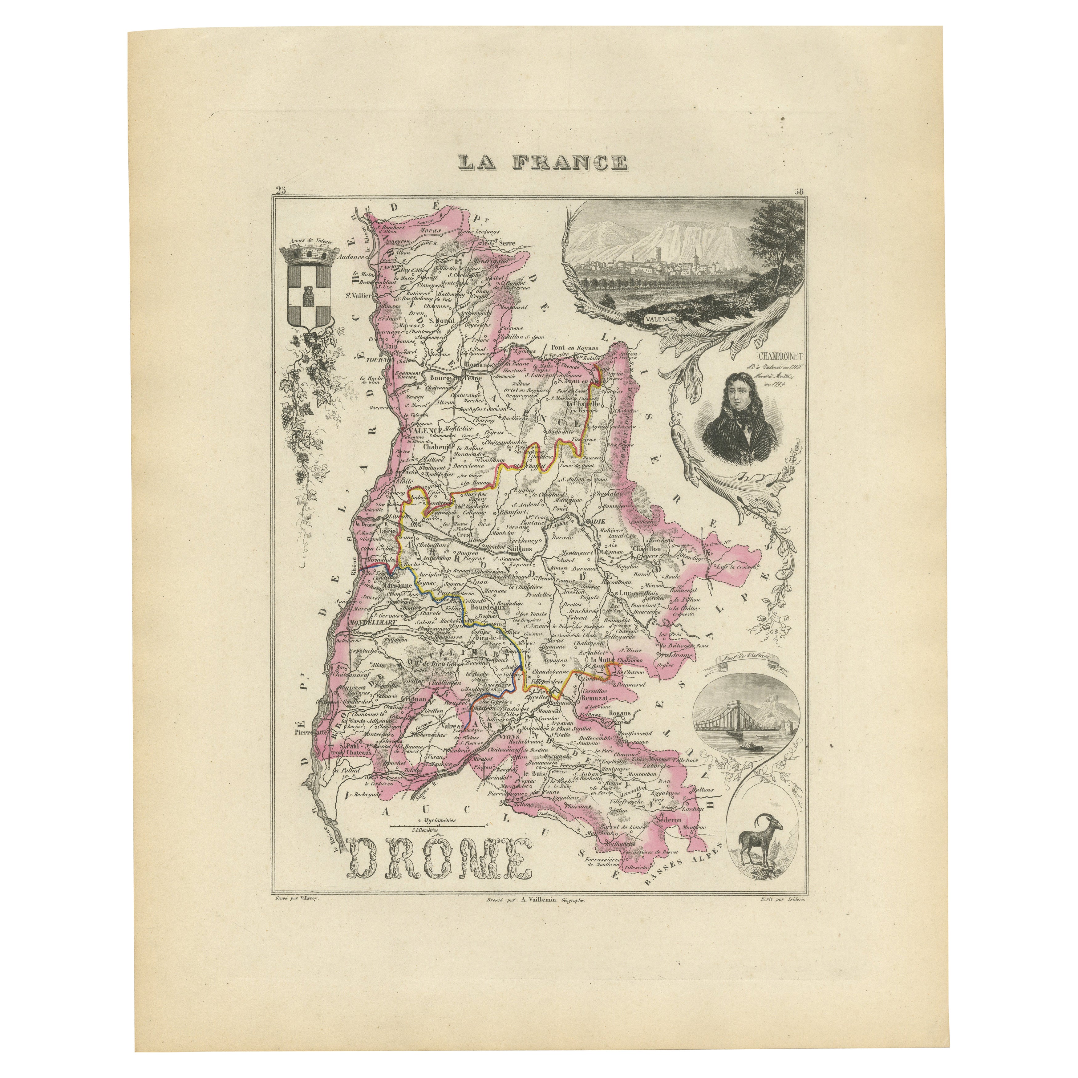
Map of Drôme France with Valence and Rhône Valley Wine Region, 19th Century
Map of Drôme France with Valence and Rhône Valley Wine Region, 19th Century
Description:
This beautifully engraved 19th-century map of the Drôme department in southeastern France wa...
Categoría
Antiguo, Mediados del siglo XIX, Francés, Mapas
Materiales
Papel
Map of Côtes-du-Nord France with Saint-Brieuc and Brittany Coastline, c.1850
Map of Côtes-du-Nord France with Saint-Brieuc and Brittany Coastline, 19th c
Description:
This elegant 19th-century map of Côtes-du-Nord, the historic name for what is now known as ...
Categoría
Antiguo, Mediados del siglo XIX, Francés, Mapas
Materiales
Papel

Map of Ardèche France with Annonay and Vineyards by Vuillemin, 19th c
Map of Ardèche France with Annonay and Vineyards by Vuillemin, 19th c
This beautifully engraved 19th-century map of Ardèche, a department in southeastern France, comes from Alexandr...
Categoría
Antiguo, Mediados del siglo XIX, Francés, Mapas
Materiales
Papel

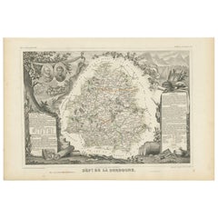
Mapa antiguo de la Dordoña "Francia" por V. Levasseur, 1854
Mapa antiguo titulado "Dépt. de la Dordogne". Mapa del departamento francés de Dordoña, Francia. Esta zona es conocida sobre todo por su producción de Monbazillac, un vino blanco dul...
Categoría
Antiguo, Mediados del siglo XIX, Mapas
Materiales
Papel
160 € Precio de venta
Descuento del 20 %
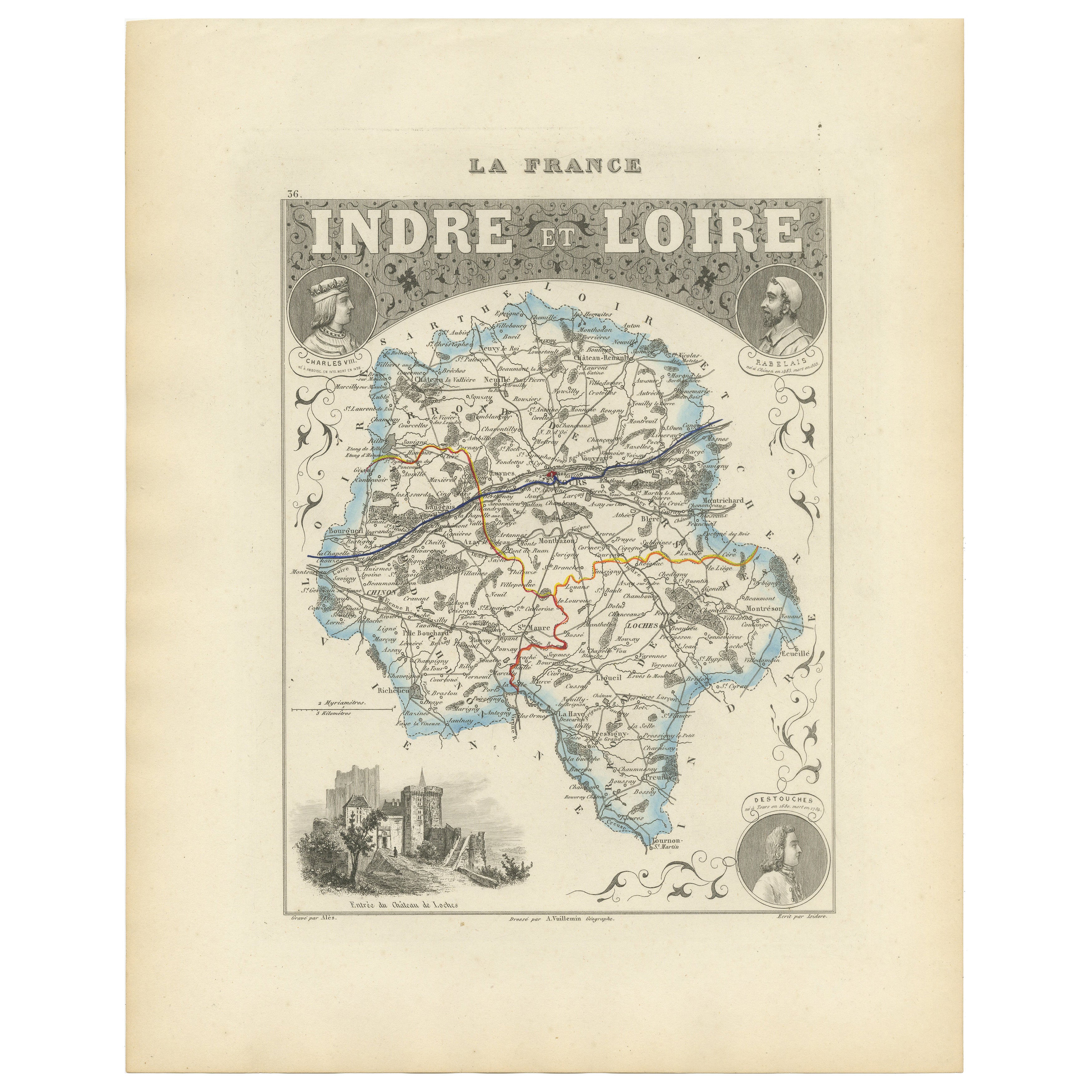
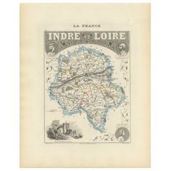
Antique French Map of Indre-et-Loire with Tours, Amboise, Chinon, 1800s
Mapa antiguo de Indre-et-Loire, Francia, por Vuillemin, siglo XIX
Este mapa bellamente grabado ilustra el departamento de Indre-et-Loire, situado en la región Centro-Val del Loira d...
Categoría
Antiguo, Mediados del siglo XIX, Francés, Mapas
Materiales
Papel
También te puede gustar
Mapa de Bonne de 1771 de Poitou, Touraine y Anjou, Francia, Ric.a015
1771 Bonne Map de Poitou,
Touraine y Anjou, Francia
Ric.a015
1771 Bonne mapa de Potiou, Touraine y Anjou titulado "Carte des Gouvernements D'Anjou et du Saumurois, de la Tou...
Categoría
Antiguo, siglo XVII, Desconocido, Mapas
Materiales
Papel

Gran mapa de Francia del siglo XIX
Gran mapa de Francia del siglo XIX.
Notable estado, con una agradable pátina desgastada por el tiempo.
Recientemente enmarcado.
Francia Circa 1874.
Categoría
Antiguo, Fines del siglo XIX, Francés, Mapas
Materiales
Lino, Papel

Saona y Loira, Francia. Mapa antiguo de un departamento francés, 1856
Por Victor Levasseur
Dept. de Saone et Loire", grabado en acero con contorno original coloreado a mano, 1856, del Atlas National Illustre de Levasseur.
El departamento francés de Saone et Loire está en...
Categoría
siglo XIX, Naturalista, Impresiones de paisajes
Materiales
Grabado

Aube, Francia. Mapa antiguo de un departamento francés, 1856
Por Victor Levasseur
Dept. de L'Aube", grabado en acero con contorno original coloreado a mano, 1856, del "Atlas National Illustre" de Levasseur.
Esta zona de Francia es conocida por su producción de C...
Categoría
siglo XIX, Naturalista, Impresiones de paisajes
Materiales
Grabado

Lozere, Francia. Mapa antiguo de un departamento francés, 1856
Por Victor Levasseur
Dept. de La Lozere", grabado en acero con contorno original coloreado a mano, 1856, del "Atlas National Illustre" de Levasseur.
Esta remota zona montañosa de Languedoc es rural, po...
Categoría
siglo XIX, Naturalista, Impresiones de paisajes
Materiales
Grabado

L'Isere, Francia. Mapa antiguo del departamento francés, 1856
Por Victor Levasseur
Dept. de L'Isere", grabado en acero con contorno original coloreado a mano, 1856, del "Atlas National Illustre" de Levasseur.
Esta zona es conocida por su producción de Bleu du Ver...
Categoría
siglo XIX, Naturalista, Impresiones de paisajes
Materiales
Grabado
