Artículos similares a Map of Drôme France with Valence and Rhône Valley Wine Region, 19th Century


¿Quieres más imágenes o vídeos?
Solicita imágenes o vídeos adicionales al vendedor
1 de 10
Map of Drôme France with Valence and Rhône Valley Wine Region, 19th Century
140 €IVA incluido
Acerca del artículo
Map of Drôme France with Valence and Rhône Valley Wine Region, 19th Century
Description:
This beautifully engraved 19th-century map of the Drôme department in southeastern France was created by Alexandre Vuillemin and published by Migeon in Paris as part of the *Nouvel Atlas Illustré*. Combining precise geography with classical decoration, this map offers a detailed portrait of a region that bridges the Alpine foothills and the fertile Rhône Valley.
Outlined in soft hand-colored pink, the map includes towns, roads, rivers, and administrative borders. Valence, the departmental capital and a historic gateway to the south of France, is prominently placed near the top. Other notable towns such as Montélimar, Die, and Nyons are labeled with clarity, and the layout captures the topographical transition from mountainous terrain in the east to the flatter Rhône corridor in the west.
At the top right, a vignette of Valence shows the town nestled beneath the Vercors mountains. Below that is a portrait of the French dramatist Pierre-Antoine de Chamfort, who was born in Clermont-Ferrand but had associations with the intellectual life of the region. Additional engravings include a suspension bridge over the Rhône River and an image of a goat, likely referencing the local production of regional cheeses and pastoral traditions.
Drôme lies in the heart of the Côtes du Rhône wine region, particularly its southern section. The department is home to some well-regarded appellations including Crozes-Hermitage, Hermitage, and Clairette de Die. These wines—made from Syrah, Marsanne, Roussanne, and Muscat, among other grapes—are known for their rich textures, spice, and balance. In addition to viticulture, the region is also recognized for truffle production, olive oil, nougat from Montélimar, and lavender fields in the southern zones.
This antique map is a fitting tribute to Drôme’s blend of agricultural richness, cultural history, and natural beauty. It is a wonderful addition to any collection of wine-related maps, regional French art, or decorative cartography.
Condition summary:
Very good condition with slight age toning and a few minor foxing marks along the margins. The engraved lines are sharp and the original hand coloring remains vibrant.
Framing tips:
A walnut or dark oak frame will complement the regional warmth of the Drôme landscape. Use a light cream or muted lavender mat to match the coloring and draw out the engraved vignettes. UV-protective glass is recommended for preservation and clarity.
- Dimensiones:Altura: 26,1 cm (10,28 in)Anchura: 32,5 cm (12,8 in)Profundidad: 0,2 mm (0,01 in)
- Materiales y técnicas:Papel,Grabado
- Lugar de origen:
- Época:
- Fecha de fabricación:circa 1850
- Estado:Very good condition with slight age toning and a few minor foxing marks along the margins. The engraved lines are sharp and the original hand coloring remains vibrant.
- Ubicación del vendedor:Langweer, NL
- Número de referencia:Vendedor: BG-13331-251stDibs: LU3054345363872
Sobre el vendedor
5,0
Vendedor reconocido
Estos prestigiosos vendedores son líderes del sector y representan el escalón más alto en cuanto a calidad y diseño de artículos.
Vendedor Platino
Vendedores premium con una calificación de +4,7 y tiempos de respuesta de 24 horas
Establecido en 2009
Vendedor de 1stDibs desde 2017
2655 ventas en 1stDibs
Tiempo de respuesta usual: <1 hora
- EnvíoRecuperando presupuesto…Envío desde: Langweer, Países Bajos
- Política de devolución
Partes de esta página se han traducido automáticamente. 1stDibs no puede garantizar la exactitud de las traducciones. El inglés es el idioma predeterminado de este sitio web.
Garantía de autenticidad
En el improbable caso de que haya algún problema con la autenticidad de un artículo, ponte en contacto con nosotros en un plazo de 1 año para recibir un reembolso total. DetallesGarantía de devolución de dinero
Si tu artículo no es como se describe, sufre daños durante el transporte o no llega, ponte en contacto con nosotros en un plazo de 7 días para recibir un reembolso total. DetallesCancelación dentro de las 24 horas
Tienes un período de gracia de 24 horas para reconsiderar tu compra, sin preguntas.Vendedores profesionales aprobados
Nuestros vendedores de primera clase deben cumplir estrictos estándares de servicio para mantener la integridad de nuestros anuncios.Garantía de igualación de precios
Si encuentras que un vendedor publicó el mismo artículo por un precio menor en otro lado, igualaremos ese precio.Entrega global de confianza
Nuestra red de transporte de primera ofrece opciones de envío especializado en todo el mundo, que incluye envío personalizado.Más de este vendedor
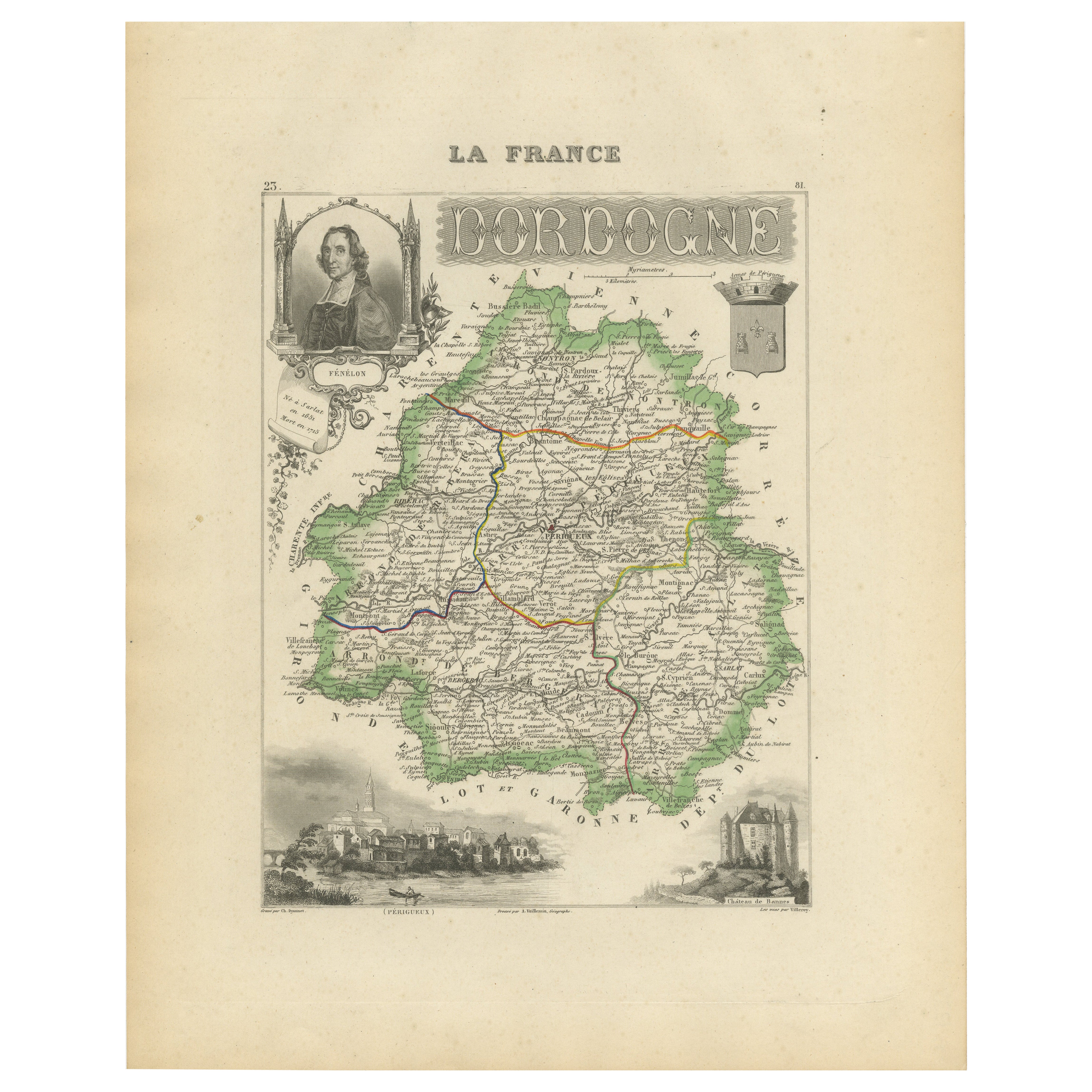
Ver todoMap of Dordogne France with Périgueux and Château de Jumilhac, 19th Century
Map of Dordogne France with Périgueux and Château de Jumilhac, 19th Century
Description:
This richly detailed 19th-century map of the Dordogne department in southwestern France was ...
Categoría
Antiguo, Mediados del siglo XIX, Francés, Mapas
Materiales
Papel
Map of Allier France with Saint-Pourçain Wine Region by Vuillemin, 19th c
Map of Allier France with Saint-Pourçain Wine Region by Vuillemin, 19th c
This decorative 19th-century map of Allier, a central department of France, comes from the celebrated Nouve...
Categoría
Antiguo, Mediados del siglo XIX, Francés, Mapas
Materiales
Papel

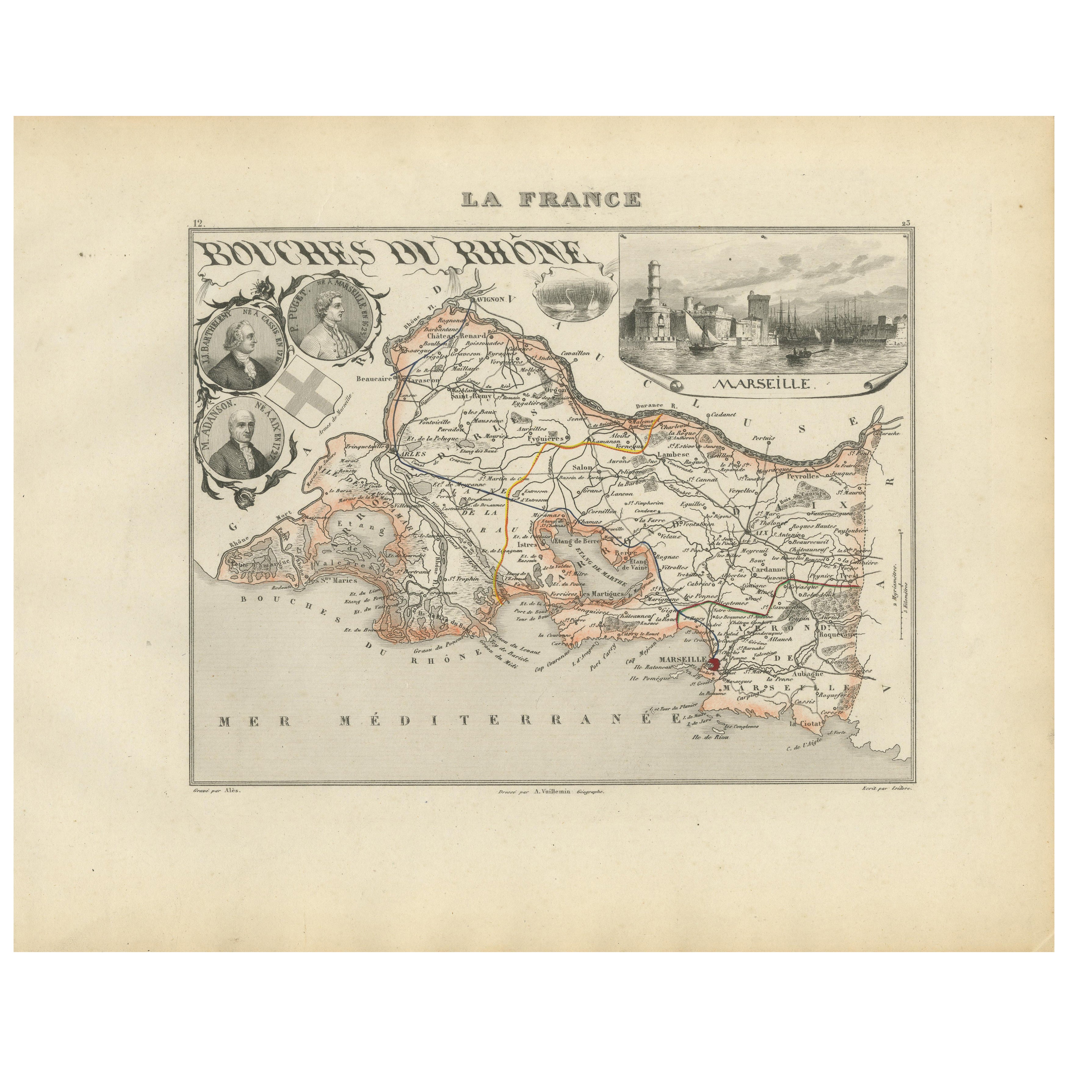
Map of Bouches-du-Rhône France with Marseille and Rhône Delta, 19th Century
Map of Bouches-du-Rhône France with Marseille and Rhône Delta, 19th Century
Description:
This finely engraved 19th-century map of the Bouches-du-Rhône department in southeastern Fra...
Categoría
Antiguo, Mediados del siglo XIX, Francés, Mapas
Materiales
Papel
Map of Côtes-du-Nord France with Saint-Brieuc and Brittany Coastline, c.1850
Map of Côtes-du-Nord France with Saint-Brieuc and Brittany Coastline, 19th c
Description:
This elegant 19th-century map of Côtes-du-Nord, the historic name for what is now known as ...
Categoría
Antiguo, Mediados del siglo XIX, Francés, Mapas
Materiales
Papel

Map of Côte-d'Or France with Dijon and Burgundy Wine Region, 19th Century
Map of Côte-d'Or France with Dijon and Burgundy Wine Region, 19th Century
Description:
This beautifully engraved 19th-century map of Côte-d'Or, located in the historic region of Bur...
Categoría
Antiguo, Mediados del siglo XIX, Francés, Mapas
Materiales
Papel

Map of Aisne France with Soissons and Champagne Vineyards by Vuillemin, 19th c
Map of Aisne France with Soissons and Champagne Vineyards by Vuillemin, 19th c
Description:
This richly detailed 19th-century engraved and hand-colored map of the department of Aisn...
Categoría
Antiguo, Mediados del siglo XIX, Francés, Mapas
Materiales
Papel

También te puede gustar
Gran mapa de Francia del siglo XIX
Gran mapa de Francia del siglo XIX.
Notable estado, con una agradable pátina desgastada por el tiempo.
Recientemente enmarcado.
Francia Circa 1874.
Categoría
Antiguo, Fines del siglo XIX, Francés, Mapas
Materiales
Lino, Papel

Mapa de la Haute Vienne - Litografía original - Siglo XIX
Mapa de la Haute Vienne es una obra de arte litográfica original realizada por un Grabador anónimo del siglo XIX.
Impreso en la serie de "Francia Pittoresca".
Titulado "Francia P...
Categoría
siglo XIX, Moderno, Impresiones figurativas
Materiales
Litografía

L'Isere, Francia. Mapa antiguo del departamento francés, 1856
Por Victor Levasseur
Dept. de L'Isere", grabado en acero con contorno original coloreado a mano, 1856, del "Atlas National Illustre" de Levasseur.
Esta zona es conocida por su producción de Bleu du Ver...
Categoría
siglo XIX, Naturalista, Impresiones de paisajes
Materiales
Grabado

Francia, Parte Norte. Mapa antiguo Century Atlas
El Atlas del Siglo. Francia, Parte Norte".
Mapa antiguo original, 1903.
Mapas en recuadro de "Francia en provincias" y "París y alrededores".
Pliegue central como se emitió. Nombre...
Categoría
principios del siglo XX, Victoriano, Más impresiones
Materiales
Litografía

Mapa del Ródano - Grabado original - Siglo XIX
Mapa del Ródano es un aguafuerte antiguo original realizado por un grabador anónimo del siglo XIX.
Impreso en serie de "France Pittoresque" en la parte superior central.
El estado ...
Categoría
siglo XIX, Moderno, Impresiones figurativas
Materiales
Grabado químico

Aude, Francia. Mapa antiguo de un departamento francés, 1856
Por Victor Levasseur
"Dept. de L' Aude", grabado en acero con contorno original coloreado a mano., 1856, del "Atlas National Illustre" de Levasseur.
Esta zona de Francia es famosa por su gran variedad ...
Categoría
siglo XIX, Naturalista, Impresiones de paisajes
Materiales
Grabado
